

California map
Albany map
About 19,439 people live here (Census Bureau, 2024 estimate). The sheet's index lists 75 streets; Eastshore Freeway, Cornell Avenue and Kains Avenue cross the most grid squares. Also on it: Albany Plateau, Albany Beach and Albany Branch Alameda County Library.
Open the map (PDF, US Letter)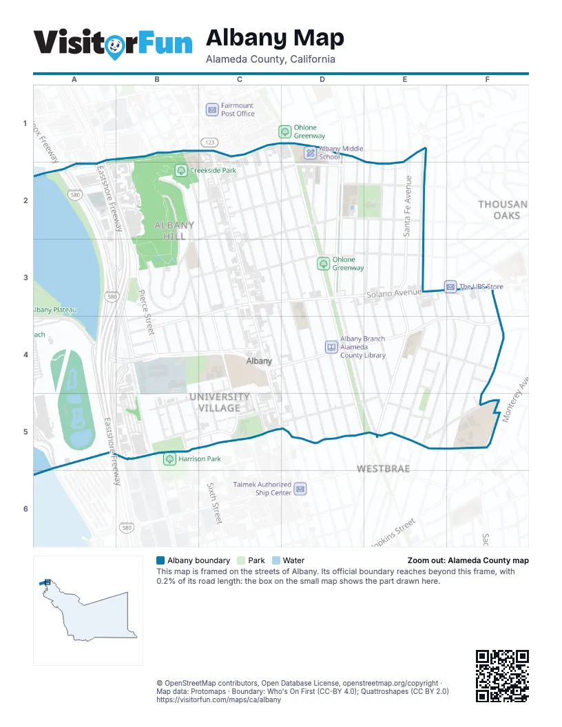
Street index of Albany
Each street on the sheet and the grid squares it crosses.
- Cornell AvenueC1, C2, C3, D3, D4, D5
- Evelyn AvenueC1, D2, D3, D4, D5
- Kains AvenueC1, C2, C3, C4, D4, D5
- San Pablo AvenueC1, C2, C3, C4, C5, D5
- Stannage AvenueC1, C2, C3, D4, D5
- Talbot AvenueC1, C2, D2, D3, D4, D5
- Ashbury AvenueD1
- Behrens StreetD1
- Key Route BoulevardD1, D2, D3, D4, E5
- Spokane AvenueD1, D2, D3
- Berkeley Park BoulevardE1
- Curtis StreetE1, E2, E3, E4, E5
- Santa Fe AvenueE1, E2, E3, E4, E5
- Visalia AvenueE1
- Cleveland AvenueA2, A3, B3, B4
- Eastshore FreewayA2, B2, A3, B3, A4, A5, B5
- Jacuzzi StreetA2
- John T. Knox FreewayA2, A3, A4, A5
- Pierce StreetA2, B2, B3, B4
- Clay StreetB2, C2
- Gateview DrivewayB2
- Hillside AvenueB2, B3
- Jackson StreetB2, B3, C3, C4, C5
- Madison StreetB2, C2, C3, C4
- Taft StreetB2, B3
- Adams StreetC2, C3, C4
- Brighton AvenueC2, D2
- Castro StreetC2, B3
- Garfield AvenueC2, D2
- Portland AvenueC2, D2, E2, C3
- Masonic AvenueD2, D3, D4, D5
- Pomona AvenueD2, D3, D4, E4, E5
- San Gabriel AvenueD2
- Thousand Oaks BoulevardD2, E2
- Carmel AvenueE2, E3, E4
- Ramona AvenueE2, E3, E4
- San Carlos AvenueE2, E3
- Calhoun StreetB3
- Cerrito StreetB3, C4
- Gateview AvenueB3
- Polk StreetB3, B4
- Washington AvenueB3, C3, D3, E3, B4
- Solano AvenueC3, D3, E3, B4
- Neilson StreetE3, E4, E5
- Ordway StreetF3, F4, E5, F5
- Peralta AvenueF3, E4, F4, E5
- Tulare AvenueF3, F4
- Ventura AvenueF3, F4, F5
- Buchanan StreetA4, B4, C4
- Eastshore HighwayA4, B4, A5, B5
- Buchanan AvenueB4
- Fillmore StreetB4
- Johnson StreetB4
- Taylor StreetB4
- Marin AvenueC4, D4, E4, F4
- Ohlone AvenueC4, B5, C5
- Albany TerraceE4
- Sonoma AvenueE4, F4
- Terrace StreetE4
- Tevlin StreetE4, E5
- Beverly PlaceF4
- Kinkead WayB5, C5
- Kula Gulf WayB5
- Liberty Ship WayB5
- Red Oak AvenueB5, C5
- Sixth StreetB5, C5
- West End WayB5
- Eighth StreetC5
- Gooding WayC5
- Monroe StreetC5
- Tenth StreetC5
- Dartmouth StreetD5, E5
- Francis StreetE5
- Posen AvenueE5, F5
- West PlaceF5
Places on the map
- Albany Aquatic Center
- Albany Beach
- Albany Branch Alameda County Library
- Albany Bulb
- Albany Children's Center
- Albany City Hall
- Albany Fire Station
- Albany High School
- Albany Hill
- Albany Hill Park
- Albany Little League Krone Field
- Albany Little League Ocean View Field
- Albany Little League Victory Field
- Albany Middle School
- Albany Middle School Annex
- Albany Neck
- Albany Plateau
- Albany Post Office
- Albany Preschool
- Albany Senior Center
- Albany United Methodist Church
- AMS Garden
- Bank of America
- Bayshore Supply
- Belmont Village Senior Living
- Bright Star Montessori
- Buchanan Street
- California Orientation Center for the Blind
- Church on the Corner
- Cornell Elementary School
- Creekside Park
- El Cerrito Tires & Auto Body
- Fielding East
- Fielding West
- Flowerland
- Goodwill
- Kaady Car Wash
- Little Bears Daycare
- Living Hope International Christian Church
- Ohlone Greenway
Next to Albany
- Thousand Oaks
- Westbrae
© OpenStreetMap contributors, Open Database License, openstreetmap.org/copyright · Map data: Protomaps · Boundary: Who's On First (CC-BY 4.0); Quattroshapes (CC BY 2.0)















