

California map
Arcata map
About 18,748 people live here (Census Bureau, 2024 estimate). The sheet's index lists 300 streets; Redwood Highway, 11th Street and H Street cross the most grid squares. Things to do inside the boundary: Arcata Plaza.
Open the map (PDF, US Letter)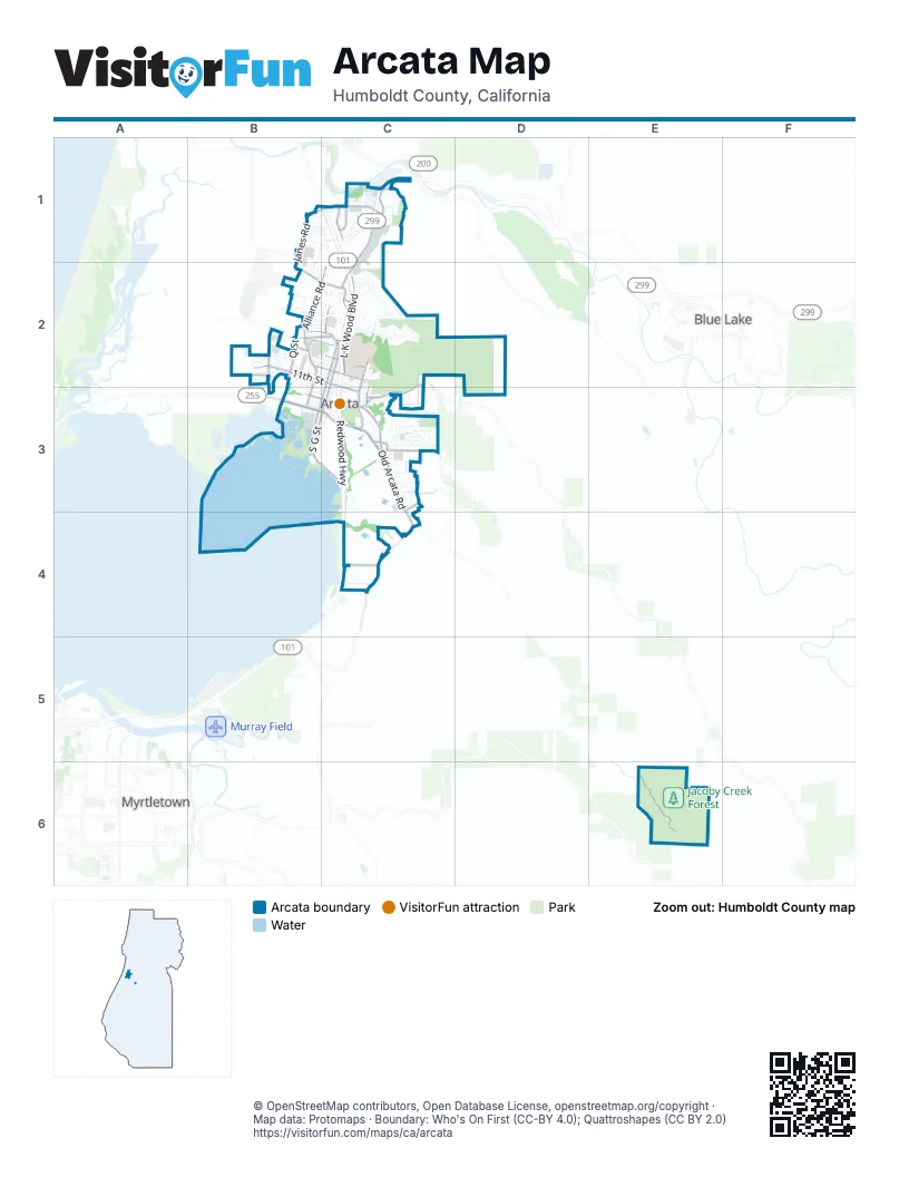
Street index of Arcata
Each street on the sheet and the grid squares it crosses.
- Redwood HighwayC1, C2, C3, C4
- Old Arcata RoadC3, C4
- Samoa BoulevardB3, C3
- L K Wood BoulevardC2
- West End RoadC1, C2
- Alliance RoadB2, C2
- 11th StreetB2, C2, C3
- H StreetC2, B3, C3
- Jacoby Creek RoadC4, E6
- South G StreetB3, C3
- Union StreetC2, C3
- Giuntoli LaneB1, C1
- G StreetC2, C3
- Janes RoadB1, B2
- Bayside RoadC3
- Fickle Hill RoadC2, C3
- Buttermilk LaneC3
- 7th StreetB3, C3
- Spear AvenueB2, C2
- 14th StreetB2, C2
- K StreetB2, B3
- Q StreetB2
- Sunset AvenueB2, C2
- 17th StreetB2, C2
- Valley West BoulevardC1
- Bayside CutoffC4
- Park AvenueC3
- Foster AvenueB2, C2
- Saint Louis RoadC2
- Valley East BoulevardC1
- Baldwin StreetC2
- Golf Course RoadC3
- Bayview StreetC2, C3
- Crescent WayC3
- V StreetB2
- Vassaide RoadB2
- Saint Louis OverpassC2
- West End RoundaboutC2
- Sunnybrae CenterC3
- Diamond DriveC2
- F StreetC2, C3
- South I StreetB3
- East California AvenueC2
- J StreetB2, C2, B3
- 12th StreetB2, C2, C3
- 13th StreetB2, C2
- I StreetC2, B3
- 10th StreetB2, C2, C3
- Stromberg AvenueB2, C2
- Beverly DriveC3
- Shirley BoulevardC3
- Panorama DriveC3
- Boyd RoadC1
- 9th StreetB2, B3, C3
- Weeot WayB1, C1
- Ericson WayC1
- 5th StreetB3, C3
- Chester AvenueC3
- Terrace AvenueC2
- B StreetC2, C3
- 8th StreetB3, C3
- Courtyard CircleC1
- M StreetB2
- Anvick RoadC3
- Haeger AvenueB2
- Heindon RoadB1, C1
- California AvenueC2
- 27th StreetB2
- Alder Grove RoadC1
- Virginia WayC3
- Fernwood LaneC3
- Charles AvenueC3
- D StreetC2, C3
- Moxon LaneB2
- Villa WayB2, B3
- 16th StreetB2, C2
- Hyland StreetC3
- Granite AvenueC2
- Valley West CourtC1
- Tiger HillB2, C2
- 15th StreetB2, C2
- Zehndner AvenueB2
- Beverly WayC3
- L StreetB2, B3
- Lewis AvenueB2
- Spring StreetC2, C3
- Park DriveC2
- 6th StreetB3, C3
- Vaissade RoadB2
- West End CourtC1, C2
- A StreetC2, C3
- Potawat Indian Health VillageB1, C1, B2
- Janes Creek DriveC2
- Stewart AvenueB2
- Grotzman RoadC3
- Hilfiker DriveB2, C2
- Margaret LaneC3
- Hidden Creek RoadC2
- Grant AvenueB2, C2
- Wyatt LaneB2
- Eye StreetC2
- O StreetB2
- C StreetC2, C3
- Rossow StreetC2
- Redwood Park RoadC2, C3
- Palomino LaneB1, C1
- East Laurel DriveC2
- Coombs CourtC2
- Curtis AvenueC2
- Blakeslee AvenueB2
- Iverson AvenueB2
- Laurel DriveC2
- Lippizan WayC1
- Roberts WayB2
- Greenbriar LaneC2
- Woodland CourtC2
- Anderson LaneC3
- Hallen DriveC1
- Mustang LaneB1, C1
- Ribeiro LaneB2
- Mc Callum CircleC2
- Appaloosa LaneB1, C1
- Grotzman LaneC3
- Evergreen AvenueC2
- Western AvenueB2
- Eastern AvenueB2
- E StreetC3
- Ariel WayB2
- Harpst StreetC2
- N StreetB2, B3
- East 12th StreetC3
- Brigid LaneC3
- S StreetB2
- Heather LaneB2
- East 11th StreetC3
- Larry StreetB2
- Sierra WayC1
- Frederick AvenueB2
- Forest AvenueC2
- 30th StreetB2, C2
- Felix AvenueB2, C2
- Bayside CourtC3
- Davis WayC2
- Shetland LaneB1, C1
- Hilltop CourtC2
- Wilson AvenueC2
- Cropley WayB2, C2
- Redwood AvenueC2
- Karen CourtB2
- McMillan DriveC2
- Acheson WayB2
- Lincoln AvenueB2, C2
- 4th StreetC3
- Center AvenueC3
- Patrick CourtC3
- Graham RoadC4
- Todd CourtC2
- Wisteria WayB2
- Zelia CourtC2
- Benjamin CourtB2, C2
- Ley-Chehl LaneC2
- Spring Hill RoadC4
- Carlson Park DriveC1
- Panorama CourtC3
- Ponderosa WayC1
- Spruce WayC1
- Beith CourtC3
- Aloha DriveC2
- Monterey DriveC1
- Doctor Martin Luther King Junior ParkwayC3
- Mack RoadC2
- Sylva StreetC2
- Olympia StreetC1
- Trojan StreetC1
- 3rd StreetC3
- Chestnut PlaceB2
- 18th StreetC2
- Airstream AvenueC1
- Mad River Parkway EastC1
- Percheron LaneC1
- Bayview CourtC2
- East 16th StreetC2
- Kit StreetC1
- East 17th StreetC2
- Maple LaneC2
- Antoine AvenueB2, C2
- Daniels StreetB2
- Ribeiro CourtB2
- Cedar DriveC1
- Noga LaneC3, C4
- 29th StreetB2
- R StreetB2
- P StreetB2
- Sunset CourtC2
- Poplar DriveC1
- Austin WayB2
- Meadow Creek WayC2
- Dunbar CourtC2
- Susan AvenueB2
- Jay StreetC2
- Sherri CourtB2
- Ross StreetC2
- Oasis StreetC1
- Blake CourtC3
- Plaza AvenueC2
- Tina CourtB2
- Cranbrook StreetC1
- Tanglewood RoadC2
- Sparton StreetC1
- Highland CourtC2
- Quarter WayB1
- Arabian WayC1
- Mc Dowell CourtC2
- Adams CourtB2
- Dorothy CourtC3
- Chesnut WayB1
- Irene StreetC3
- Clipper LaneC3
- Ericson CourtC1
- Mc Kinnon CourtC1
- Marilyn AvenueC3
- Frank Martin CourtC1
- Mad River Parkway WeatC1
- Myrtle CourtC3
- Clover WayC2
- Janes CourtB1
- McMillan CourtC2
- Antoinnette CourtB2
- Stewart CourtB2
- Mad River ParkwayC1
- 24th StreetC2
- Madrone WayC2
- Cluster CourtC2
- East 14th StreetC2
- 2nd StreetC3
- Pacific CourtC2
- Maria CourtB2
- Lynn StreetC3
- Ridge RoadC2
- Anina WayB2, C2
- drivewayC1
- Bret Harte AlleyB3, C3
- Front StreetB3, C3
- Pacific AvenueC2
- Lake WayC2
- Isaac Minor AlleyC2
- Garnett StreetC2
- Chapman CourtC3
- McMahan StreetC2
- Crandell LaneB2
- Fern WayC2
- Nature Trail LoopC2, C3
- New Moon AvenueC1
- Nomad AvenueC1
- Angelus AvenueC1
- Bel Aire AvenueC1
- Mill StreetC2
- Devlin CourtC1
- North StreetB2
- Hill StreetC3
- Leon LaneC2
- Martha CourtB2
- Parkland StreetC2
- Lena AvenueC3
- Sequoia AvenueC2
- Tilley CourtC3
- Wiley CourtC3
- Belle Falor CourtC1
- Hialeah CourtC1
- Canyon RoadC2
- Chester LaneC3
- East 15th StreetC2
- L K Wood CourtC2
- Roberts Court EastC2
- Jessica CourtB2
- Roberts Court WestC2
- Westwood CourtB2
- Deerfern CourtC2
- Simas CourtB2
- Crestwood CourtC1
- Hauser CourtC2
- Anina CourtB2
- Scott CourtB2
- Sandra CourtB2
- Pepperwood LaneC1
- Beverly CourtC3
- Buttermilk CourtC3
- Charles CourtC3
- Estelle CourtC2
- Preakness CourtC1
- Van Dyke CourtC1
- Keenland CourtC1
- North Quarter CircleB1
- Olson CourtB2
- Saratoga CourtC1
- Bay Meadows CourtC1
- Daina CourtB2
- Gulfstream CourtC1
- Sorrel CircleC1
- Bay CircleC1
Things to do on the Arcata map
Places on the map
- 4th Street Market
- Ace Hardware
- Aldergrove Marsh
- Arcata Ball Park
- Arcata Church of the Nazarene
- Arcata City Hall
- Arcata Community Center
- Arcata Community Forest
- Arcata Elementary School
- Arcata High School
- Arcata Marsh and Wildlife Sanctuary
- Bayside Park Farm
- Bloomfield Elementary School
- Brackish Pond
- Butchers Slough Log Pond
- California State Polytechnic University, Humboldt
- Carlson Park
- Cypress Grove Chevre
- Gearheart Marsh
- Greenwood Cemetery
- Hauser Marsh
- Jacoby Creek Elementary School
- Jacoby Creek Forest
- Klopp Lake
- Mad River Business Park
- Mad River Community Hospital
- Mad River Rapids RV Park
- Mail Room
- North Oxidation Pond
- Pacific Union Park
- Pacific Union School
- Redwood Park
- Shay Park
- South Oxidation Pond
- Sunny Brae Middle School
- Sunny Brae Park
- The Mill Yard
- Valley West Park
- Valley West Shopping Center
- Western Pond
Next to Arcata
- Blue Lake
- Myrtletown
© OpenStreetMap contributors, Open Database License, openstreetmap.org/copyright · Map data: Protomaps · Boundary: Who's On First (CC-BY 4.0); Quattroshapes (CC BY 2.0)















