

California map
Humboldt County map
About 132,380 people live here (Census Bureau, 2024 estimate). The sheet's index lists 300 streets; Redwood Highway, Main Street and Mattole Road cross the most grid squares. Things to do inside the boundary: Arcata Plaza, Avenue of the Giants and Bear River Casino Resort.
Open the map (PDF, US Letter)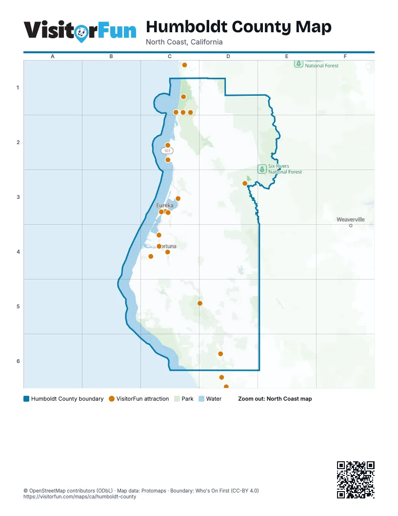
Street index of Humboldt County
Each street on the sheet and the grid squares it crosses.
- Redwood HighwayC1, C2, C3, C4, C5, D5, D6
- Trinity HighwayC3, D3
- Bigfoot Scenic BywayD2, D3
- Broadway StreetC3
- 5th StreetC3, C4, D6
- 4th StreetC3, C4, C5, D6
- Trinity Highway / CA Hwy 299D3
- Placer Claim RoadE1
- West 5th StreetC3
- West 4th StreetC3
- Grizzly Creek BridgeD4
- Alderpoint RoadD4, D5, D6
- Kneeland RoadC3, C4, D4
- Avenue of the GiantsC5, D5, D6
- Briceland-Thorn RoadC6, D6
- New Navy Base RoadC3
- Shelter Cove RoadC6
- Newton B Drury Scenic ParkwayC1
- Main StreetC2, C3, C4, C5, D6
- Greenwood Heights DriveC3
- Blue Lake BoulevardC3, D3
- Myrtle AvenueC3
- Central AvenueC3, C4
- Freshwater RoadC3
- Elk River RoadC3, C4
- Murray RoadC3
- Redwood DriveD6
- Samoa BoulevardC3
- Old Arcata RoadC3
- H StreetC3, C4
- F StreetC3
- Glendale DriveC3
- Rohnerville RoadC4
- Walnut DriveC3, C4, C5
- I StreetC3, C4
- E StreetC3
- French RoadD5
- Harris StreetC3
- North Bank RoadC3
- 3rd StreetC3, C4, D6
- South Rohnerville RoadC4
- South Fortuna BoulevardC4
- Maple Hills RoadD5
- Ridgewood DriveC4
- S StreetC3
- Harrison AvenueC3, C4
- Fairway DriveC3, D3, D6
- Campton RoadC3
- R StreetC3
- Fernbridge DriveC4
- Henderson StreetC3
- Ross Hill RoadC4
- V StreetC3
- School StreetC4, D6
- Wildwood AvenueC4
- West AvenueC3, C4
- Herrick AvenueC3
- Davis StreetC3, C4
- West Harris StreetC3
- Indianola CutoffC3
- Dean Creek RoadD6
- North Fortuna BoulevardC4
- West Henderson StreetC3
- West Wabash AvenueC3
- W StreetC3
- Wabash AvenueC3
- FernbridgeC4
- Hemlock StreetC3
- Barkdull RoadC5
- Eagle Prairie BridgeC4
- Hall AvenueC3
- Singley RoadC4
- Scenic WayC4
- Indianola Cutoff undercrossingC3
- Thorn JunctionC6
- Mattole RoadB4, C4, B5, C5, D5
- Berry Summit-Mad River RoadD3, D4, E4
- Bald Hills RoadC1, C2, D2
- Maple Creek RoadC3, D3, D4
- Dyerville Loop RoadD5, D6
- State Highway 169D1, D2
- Bair RoadD2, D3
- Bluff Creek RoadD1, D2
- Showers Pass RoadD4
- Old California State Route 299C3, D3
- Wilder Ridge RoadC5, C6
- Fickle Hill RoadC3
- King Peak RoadC6
- Mountain View RoadC4, D4
- Shively RoadC4, C5
- Road 15C3, C4
- Bell Springs RoadD6
- Fort Seward RoadD5
- Sprowel Creek RoadD6
- Yager Lawrence MainlineC4
- Butler Valley RoadC3, D3
- Tompkins Hill RoadC4
- Island Mountain RoadD6, E6
- Stover RoadD2, D3
- Old Briceland RoadD6
- West End RoadC3
- Gasquet-Orleans RoadD1, E1
- Road 11C4
- Eel River DriveC4
- Jacoby Creek RoadC3
- Grizzly Bluff RoadC4
- Ettersburg RoadC6
- Patrick's Point DriveC2
- Blue Slide RoadC4, C6
- Benbow DriveD6
- Fieldbrook RoadC3
- Titlow Hill RoadD3
- Chemise Mountain RoadC6
- Newton RoadD5
- Zenia Bluff RoadD5, E5, D6
- Pacific Lumber Company RoadC5, D5
- Mad River RoadC3
- Mitchell RoadD2, C3
- Road 10C4
- G StreetC3
- Scenic DriveC2, C4
- Union StreetC3
- Palco RoadC4
- J StreetC3, C4
- Larabee Ranch RoadD5
- D StreetC3, C4
- Hookton RoadC4
- Wrigley RoadC4
- Road 30C4
- K StreetC3, C4
- 14th StreetC3, C4
- 9th StreetC3, C4
- 11th StreetC3, C4
- Waddington RoadC4
- Spring StreetC3, C4
- 6th StreetC3, C4, C5, D6
- Airport RoadC3, C4
- Railroad AvenueC3, C4, C5, D5
- C StreetC3, C4
- Foster AvenueC3
- California StreetC3, C4
- 7th StreetC3, C4
- 12th StreetC3, C4
- Humboldt Hill RoadC3, C4
- Old California State Route 211C4
- Seeley McIntosh RoadD3
- Eyesee RoadE1
- 2nd StreetC3, C4, D6
- Holmes Flat RoadC5, D5
- Hatchery RoadC3
- Pigeon Point RoadC3
- P StreetC3, C4
- Peninsula DriveC3
- Westhaven Drive NorthC2
- School RoadC3, C5, D5
- Park StreetC3, C4
- Mill StreetC3, C4
- Trinity StreetC2, C3, C4
- McKinleyville AvenueC3
- Kenmar RoadC4
- Upper Pacific DriveC6
- Buttermilk LaneC3
- L K Wood BoulevardC3
- Cummings RoadC3
- Buhne StreetC3
- Waterfront DriveC3
- 17th StreetC3
- Alliance RoadC3
- Q StreetC3
- Azalea AvenueC3
- Golf Course RoadC3
- Westhaven Drive SouthC2
- Hodgson StreetC3
- Hiller RoadC3
- Mantova LaneC4
- Janes RoadC3
- Lower Pacific DriveC6
- Sutter RoadC3
- Loleta DriveC4
- Fairview DriveC3, C4
- Giuntoli LaneC3
- South G StreetC3
- Pacific AvenueC3, C4, D6
- Palmer BoulevardC4
- Bluff StreetC4
- 18th StreetC3
- Fern StreetC3, C4, D6
- Del Norte StreetC3
- Belleview AvenueC4
- Essex LaneC3
- 1st StreetC3, C4
- Ocean AvenueC2, C3, C4
- Bayside RoadC3
- Meyers AvenueC3
- King Salmon AvenueC3, C4
- Country Club RoadD3
- Larabee Creek RoadD5
- Sandy Prairie RoadC4
- Redwood WayC4
- Park AvenueC3, C4, D6
- Highland AvenueC2, C3, D6
- Sorenson RoadC5
- Fairfield StreetC3
- Excelsior RoadC3
- Mountain View DriveD6
- Ole Hansen RoadC3
- West 14th StreetC3
- South Broadway StreetC3, C4
- Allard AvenueC3
- Redway DriveD6
- Dolbeer StreetC3
- Spear AvenueC3
- Letz AvenueC3
- Indianola RoadC3
- Sunset AvenueC3
- Upper Bay RoadC3
- Thiel AvenueC3
- Chartin RoadC3
- Quaker StreetC3
- Manzanita AvenueC3
- McCullens AvenueC3
- Bartow RoadC3
- Glenwood StreetC3
- Riverwalk DriveC4
- Ocean DriveC3
- Oak StreetC3, C4, D5, D6
- Lewis AvenueC3
- Holly DriveC3
- Fowler LaneC4
- Bella Vista RoadC3
- Lake Benbow DriveD6
- 6th AvenueC2
- Vernon StreetC3
- Glen StreetC3
- Machi RoadC6
- McFarlan StreetC3
- South Railroad AvenueC3
- Valley West BoulevardC3
- Little Fairfield StreetC3
- Bayside CutoffC3
- West Buhne StreetC3
- 2nd RoadC3
- Saint Louis RoadC3
- Buhne DriveC3, C4
- Lime AvenueC3
- Washington AvenueC3
- Railroad StreetC3
- Valley East BoulevardC3
- Kay AvenueC2
- Lum StreetD5
- Hubbard LaneC3
- Baldwin StreetC3
- Highland StreetC3
- Singley LaneC4
- Bayview StreetC3
- Lucas StreetC3
- Wildcat AvenueC4
- Vance StreetC3
- Young LaneC3, D3
- Crescent WayC3
- Fields Landing DriveC4
- Greenwood RoadC3
- Chester StreetC3
- Vassaide RoadC3
- Lupin DriveC3
- Sunnybrae CenterC3
- West 7th StreetC3
- West 6th StreetC3
- Holly StreetC3
- Seawood DriveC2
- Orchard AvenueC4
- Dean AvenueC3
- Palmer Creek RoadC4
- Eureka StreetC3
- Moonstone Beach RoadC2
- Martins Ferry BridgeD2
- Hartman AvenueC3
- Alpha StreetC3
- Saint Louis OverpassC3
- Cookhouse RoadC3
- Kahlstrom AvenueC2
- Madison AvenueC3
- Silva AvenueC3
- Jordan RoadC5
- West 2nd StreetC3
- Sea BluffC3
- Belleville AvenueC4
- West Waterfront DriveC3
- West End RoundaboutC3
- Bingen AvenueC3
- Usal RoadC6
- Benbow Dam RoadD6
- Orleans-Willow Creek RoadD2, E2, D3
- Salyer-Mad River RoadD3, D4
- Cedar Camp RoadD1, D2
- Red Cap RoadD1, E1, D2, E2
- Snow Camp RoadD3
- Redwood House RoadC4, D4
- Big Hill RoadD2, E2
- Johnson RoadD1, C2, D2, C4
Things to do on the Humboldt County map
- Arcata Plaza
- Avenue of the Giants
- Bear River Casino Resort
- Blue Ox Millworks & Historic Park
- California Welcome Center Eureka
- Chapman's Gem and Mineral
- Dick Taylor Craft Chocolate
- Fern Canyon
- Ferndale
- Fortuna
- Humboldt Bay National Wildlife Refuge
- Lady Bird Johnson Grove
- M/V Madaket Harbor Cruise
- Old Town Eureka
- Redwood Creek Buckarettes
- Redwood National and State Parks
- Reggae on the River
- Samoa Cookhouse
- Sequoia Park Zoo
- Six Rivers Rafting
- Southern Humboldt
- Sue-meg State Park
- Trinidad State Beach
Places on the map
- 'O Rew Redwoods Gateway
- Agate Beach
- Alderpoint
- Arcata
- Arcata Community Forest
- Barkdull Prairie
- Bayside Bottoms
- Bayview
- Baywood Golf Course
- Benbow
- Big Flat State Marine Conservation Area
- Big Lagoon
- Big Lagoon Wildlife Area
- Big Opening
- Black Sands Beach
- Blue Lake
- Blue Lake Rancheria
- Bone Flat
- Bull Creek State Wilderness
- Eel River Wildlife Area
- Headwaters Forest Reserve
- Humboldt Bay National Wildlife Refuge
- Humboldt Lagoons State Park
- Humboldt Redwoods State Park
- King Range National Conservation Area
- King Range Wilderness
- Lacks Creek Management Area
- McKay Community Forest
- McKinleyville Community Forest
- Mike Thompson Wildlife Area
- Mount Lassic Wilderness
- Murray Field
- Murrelet State Wilderness
- Owl Creek Ecological Reserve
- Prairie Creek Redwoods State Park
- Redwood National and State Parks
- Richardson Grove State Park
- Rocks and Islands Wilderness
- Six Rivers National Forest
- Sue-meg State Park
Next to Humboldt County
- Weaverville
© OpenStreetMap contributors, Open Database License, openstreetmap.org/copyright · Map data: Protomaps · Boundary: Who's On First (CC-BY 4.0); Quattroshapes (CC BY 2.0)