

California map
Auburn map
About 13,780 people live here (Census Bureau, 2024 estimate). The sheet's index lists 300 streets; Alan S. Hart Freeway, Auburn Folsom Road and Humbug Way cross the most grid squares. Also on it: Auburn Municipal Airport, Alta Vista Elementary School and Auburn District Cemetery.
Open the map (PDF, US Letter)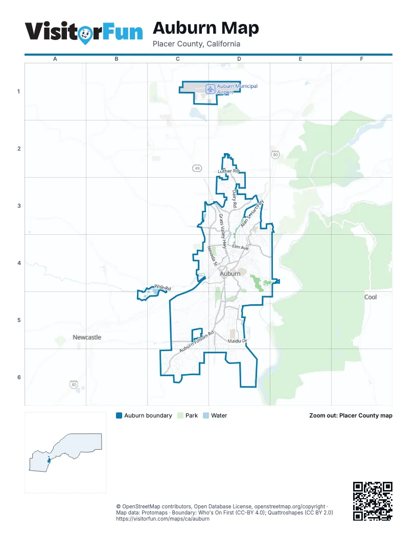
Street index of Auburn
Each street on the sheet and the grid squares it crosses.
- Alan S. Hart FreewayD3, C4, D4, C5
- Auburn Folsom RoadD4, C5, D5, C6
- Lincoln WayD3, D4
- Nevada StreetD3, D4
- Grass Valley HighwayD3, D4
- El Dorado StreetD4, E4
- Elm AvenueD4
- Placer StreetD4
- Maple StreetD4
- Maple Street BridgeD4
- High StreetC4, D4
- Indian Hill RoadC5
- Ophir RoadC4
- Auburn Ravine RoadD3, D4
- Maidu DriveD5
- Sacramento StreetD4, D5
- Dairy RoadD2, D3
- Riverview DriveD5
- Pacific AvenueD4, D5
- Pleasant AvenueD4, D5
- Shirland Tract RoadD5, D6
- Palm AvenueD3
- Marguerite Mine RoadD3
- Fulweiler AvenueD4
- Wise RoadC4
- Skyridge DriveD5
- Luther RoadD2
- Mount Vernon RoadC3, D3
- Russell RoadD3
- New Airport RoadD1
- Sunrise Ridge CircleC5, C6
- Eagles NestD5, D6
- Landis CircleD3, D4
- Aeolia DriveD3, D4
- Ridgeview CircleC6
- Foresthill AvenueD3, E3, D4
- Arroyo DriveD6
- Vintage WayC6
- Mikkelsen DriveD3
- Humbug WayC5, D5, C6, D6
- Gold StreetD4
- Rosemary DriveD5
- Auburn WoodsD3
- Rogers LaneC5
- Brook RoadD4
- Hidden Creek DriveC4
- Dale DriveD5
- Herrington DriveD5
- Finley StreetD4
- Robie DriveD4, E4
- Alta Mesa DriveD3
- Incline DriveD3
- Ginger DriveD5
- Foxridge CircleD5, D6
- Perkins WayD5
- Racetrack StreetC4, D4
- Placerado AvenueD4, E4
- College WayD4
- Earhart AvenueC1, D1
- Oak Ridge WayD2
- Timberline LaneD4
- Burlin WayD5, D6
- Baltimore RoadC5, D5
- Electric StreetD3, D4
- Huntley AvenueD3, D4
- Borland AvenueD4
- Westwood DriveD3
- Sawka DriveC5
- Deerbrook TrailC6
- Snowy Owl WayD5
- Quail Meadow DriveD2, D3
- Grandview DriveC5
- Vista Del LagoD5
- Teamtrack RoadD3, D4
- Mont Vista DriveC5
- Gum LaneD4, D5
- Brewery LaneD4
- Virginia StreetD4
- Rancho CircleD5
- Tyler DriveC6
- Live Oak StreetC4, D4
- Chamberlain AvenueD4
- Gavin CircleC6
- Olive Orchard DriveD3, D4, E4
- Southridge DriveC5, D5
- Carolyn StreetD5
- Holly Hill RoadD3
- Pine StreetD4
- Greenfield AvenueD3, E3
- Lakeridge DriveC6
- Linden AvenueD4
- Katherine WayD5
- Belmont DriveD4
- Recreation DriveD4, D5
- El Oro DriveD3
- Agard StreetD4
- Homestead WayD3
- Poet Smith DriveD5
- Blocker DriveC4, D4
- Red Hawk LaneC3, D3
- Valley View DriveD5
- Oak View TerraceC5, D5
- Orrin DriveD5
- Enterprise DriveC3, C4, D4
- Norman LaneC5, D5
- Orange StreetD4
- Bill Clark WayC1, D1
- Swenson CourtD3
- Perry Ranch RoadC5
- Andrews StreetC4, D4
- Stadium WayD4
- Walsh StreetD4
- Chana DriveD4
- Stone WayD5, D6
- Gossonia ParkD4
- Terrace StreetD4
- Locksley LaneC1
- Hoffman AvenueD4
- Highland DriveD3
- Vista del MonteD5
- Fiddler Green CourtD3
- Canyon DriveE3
- Shockley RoadD3
- Peregrine WayD6
- Church RoadD3
- Marvin WayD4
- Summit StreetD4
- Tanglewood DriveD5
- Kenmass AvenueD4
- Olive StreetD4
- Oak StreetD3, D4
- Wildwood DriveD5
- Dorothy WayD3
- East Placer StreetD4
- Hidden Meadows CircleD3
- Merrow StreetC4, D4
- Cherry AvenueD4
- Marion WayD4, E4
- Midway AvenueC4, D4
- South McDaniel DriveD5
- Shale Ridge RoadC1
- Persimmon TerraceD3
- Reamer StreetD4
- Welty LaneC4
- Shady RunD5
- Herdal DriveC5, D5
- Portland AvenueD5
- Oakhurst TerraceC5
- Toyon DriveD3, E3
- Baltic CircleD3
- Rickenbacker WayD1
- Honeybrook LaneD3
- Indian Rancheria RoadC5
- Jordan LaneD4
- Red Dog LaneC5, D5
- Palmyra StreetC5, D5
- Fawn Creek TrailC6
- Marina AvenueD4
- Homewood LaneC4
- Quail Hollow DriveD2, D3
- Wilbur WayC1
- Sawyer StreetD4
- North McDaniel DriveD5
- White StreetD4
- Merry Knoll RoadC3
- Apt parking lotD5
- Boardman StreetD4
- Brentwood CircleD5
- Gray Horse DriveD5
- Awali AvenueC4, C5
- Center StreetD4
- Lupine LaneC6
- Sluice Box CircleC5
- Stephen AvenueD3
- Knollwood DriveD5
- Sutton PlaceD5
- Dorer DriveD4
- Lindbergh StreetD1
- Montana DriveD5
- Margaret CourtC6
- Channing WayD4
- Ruby StreetD3, D4
- Adriana PlaceD5
- Ellestad WayD4
- Garfield StreetD4
- Sutter StreetD4
- Shockley Woods CourtD3
- Almond StreetD4
- Sunrise AvenueD4
- Circle DriveD4
- Secluded CourtC6
- Canyon Ridge LaneD4
- Grove CourtC3
- Buena Vista StreetC4, D4
- Oakwood DriveD4
- Sunrise VistaC6
- Blackberry CourtD3
- California StreetD4
- John LaneD4
- Lantern View DriveC5
- Epperle LaneD4
- Park StreetD4
- Parkside TerraceD4
- Rio Camino StreetD4
- Forest CourtD5
- Hyde Park DriveD2
- Pinecrest AvenueD5
- Mesa Vista WayC5
- Crimson CourtD2
- Palomino CourtC5
- East Electric StreetD3
- Dairy LaneD3
- Orr StreetD4
- Del Monte WayD4
- Kevin CourtD3
- Cedar StreetD4
- Carson AvenueD4
- Diamond StreetD3
- Bluffs PlaceC5, C6
- Cambridge CourtC5, D5
- Buckeye CourtD5
- Davis LaneD4
- Deerwood PlaceC6
- Wall StreetD3
- Harrison AvenueD4
- Lubeck RoadD4
- Stratten WayD4
- Mira Loma DriveD6
- Supreme CourtC5, D5
- Centennial CourtD2
- Tanoak WayD5
- Canyon CourtD3
- Del ReyD4
- Grace StreetD4
- Teal CourtD2
- Magnolia AvenueD4
- Graham LaneD4
- Killarney WayD2
- Tennis WayD4
- Del Valle DriveC5, D5
- Floradale LaneD2
- Manor WayD3
- Summer Ridge CourtD2
- Croman PointC6
- Sunnyslope WayC6
- Tuttle StreetD4
- Court StreetD4
- Oak Leaf CourtD2
- Val Vista WayC5
- Easy WayD4
- Eckard WayD3
- Grand Oaks DriveC5
- Washington StreetD4
- Hale StreetD4
- Hillmont AvenueD4
- Marshall WayD4
- Haswell CourtD3, D4
- Orville AvenueC1
- Blue Wing PlaceD5
- Village LaneD4
- Shockley CourtD3
- Clark StreetD4
- Fairgate RoadD4
- Vick CourtD3
- Appian WayD3
- Silkwood DriveD3
- Town View DriveD2
- Wescott CourtD4
- East StreetD4
- Neighbors LaneD4
- Cleveland AvenueD4
- Phyllis LaneD2
- Donnington AvenueD4
- Windmill WayD2
- Broadview AvenueD4
- Walker DriveD3
- Darlington AvenueD4
- Shirley StreetD4
- Cora LaneD4
- Miles CourtC4
- Lloyd WayD3
- Meadows CourtD2
- Birdsall AvenueD4
- Dana CourtC6
- Meadowlark CourtD5
- Memorial LaneD4
- Morgan CourtD4
- Celestial WayD2
- Dump RoadD5
- Machty CourtC6
- Blair StreetD4
- Woodcrest WayD4
- Marcelais CourtD3
- McCloud CourtD3
- Camjen LaneD5
- Knoll StreetD4
- Montalvo CourtD3
- Blackstone DriveD6
- Greenwood StreetD4
- Upland StreetD4
Places on the map
- Alta Vista Elementary School
- American River Canyon Overlook Park
- Ashford Park
- Auburn Ale House
- Auburn City Hall
- Auburn Crossfit gym
- Auburn District Cemetery
- Auburn Fit 1
- Auburn Municipal Airport
- Auburn Placer County Library
- Auburn Police Department
- Auburn Recreation Park
- Auburn Self Storage
- Crooked Lane Brewing Company
- Crossroads Church - South Campus
- Earl Crabbee Gym
- El Dorado Street
- Elmwood Motel
- Euro Auto Care
- EV Cain STEM Charter Middle School
- First Baptist Church
- Gai's Basket
- General Gomez
- Gietzen Station (Station #2)
- Gold Rush Subaru
- Grocery Outlet
- High Street Bible Church
- Holiday Inn Auburn
- Home
- In-N-Out Burger
- Knee Deep Brewery
- Learning Commons
- Lower Gym
- McCann Stadium
- McCaulou's
- Old Town Auburn
- Placer High School
- Railhead Park
- Skyridge Elementary School
- Wise Forebay
Next to Auburn
- Cool
- Newcastle
© OpenStreetMap contributors, Open Database License, openstreetmap.org/copyright · Map data: Protomaps · Boundary: Who's On First (CC-BY 4.0); Quattroshapes (CC BY 2.0)















