

California map
Camarillo map
About 69,881 people live here (Census Bureau, 2024 estimate). The sheet's index lists 300 streets; Ventura Freeway, Santa Rosa Road and Temple Avenue cross the most grid squares. Things to do inside the boundary: Camarillo Premium Outlets.
Open the map (PDF, US Letter)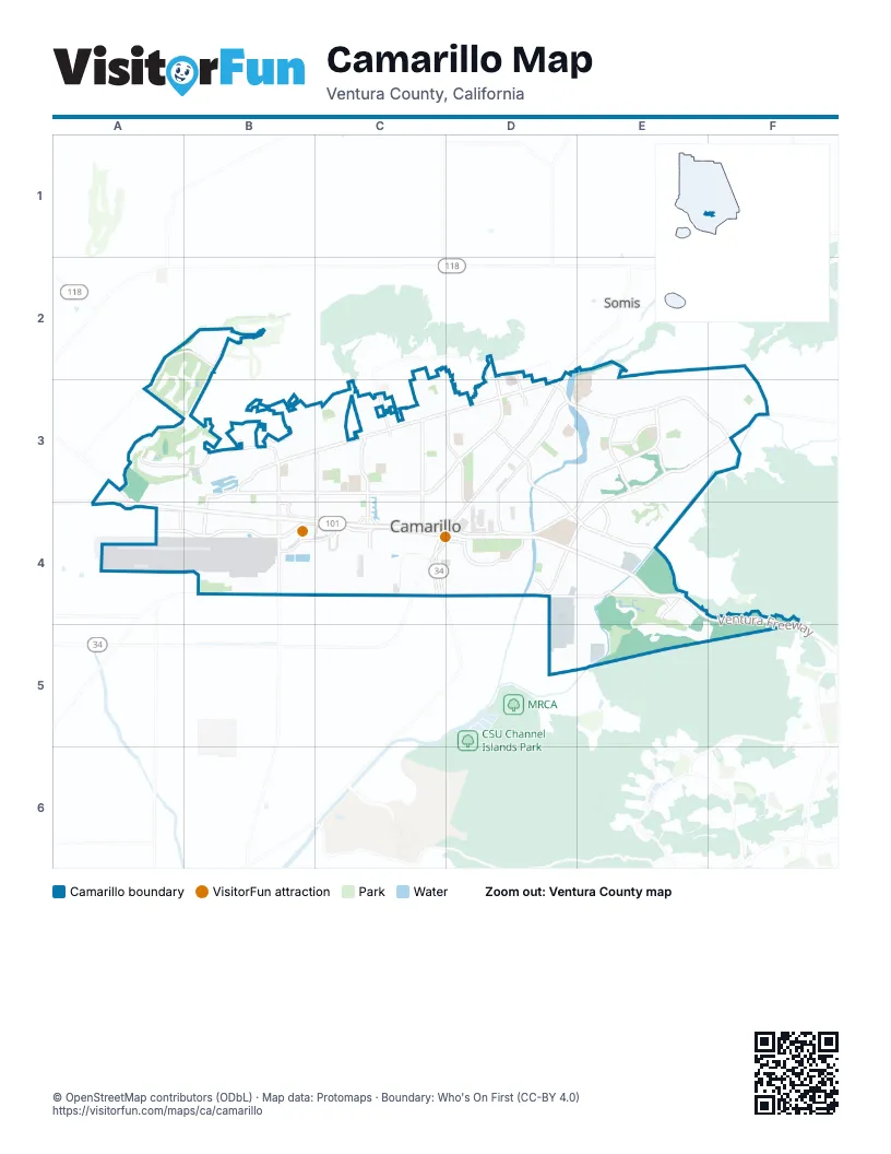
Street index of Camarillo
Each street on the sheet and the grid squares it crosses.
- Ventura FreewayA3, A4, B4, C4, D4, E4, F4, F5
- Calle CuestaD4, E4
- East Ventura BoulevardB4, C4
- East Pleasant Valley RoadC4, D4
- East Daily DriveB4, C4, D4
- North Lewis RoadD3, D4
- South Lewis RoadC4, D4
- Somis RoadD3
- Las Posas RoadB3, C3, D3
- East Ponderosa DriveB3, C3, D3
- Mission Oaks BoulevardE3, D4, E4
- Santa Rosa RoadE3, F3, D4, E4
- Upland RoadD3, E3, F3
- Adolfo RoadD3, D4, E4
- West Ponderosa DriveA3, B3
- Flynn RoadD3, D4
- Woodcreek RoadE3
- Arneill RoadC3, C4
- North Carmen DriveC3, C4
- South Las Posas RoadB4
- Temple AvenueC2, C3, D3, D4
- North Las Posas RoadB3, B4
- Earl Joseph DriveB3, B4
- Camino Tierra SantaB3, B4
- Central AvenueA3, A4
- Rosewood AvenueC3, C4
- Springville DriveB3, B4
- Oak Canyon RoadE3
- West Pleasant Valley RoadB4
- Bradford AvenueB3
- Wolverton AvenueD3
- West Daily DriveA3, A4, B4
- South Carmen DriveC4
- East Calle la SombraB3
- East Calle la GuerraB3
- Calle Los GatosB3
- Green Lawn AvenueB3
- Spring Oak RoadB3, B4
- West Calle la GuerraB3
- Calico StreetB3, B4
- Ventura BoulevardB4, C4
- West Ventura BoulevardA4, B4
- Crestview AvenueA3, B3
- Village at the Park DriveD4
- Camarillo Springs RoadE4, E5
- Ridge View StreetD4, E4
- Beardsley RoadA2, B2, A3
- Adohr LaneD4, E4, E5
- Pancho RoadD4, D5
- Los Pueblos DriveE3, E4
- Camarillo Center DriveB4, C4
- South Dawson DriveC4, D4
- Antonio AvenueD2, D3
- Fieldcrest DriveE3
- Mission DriveC3
- North Ponderosa DriveD2, D3
- North Wood RoadA3, A4
- Verdulera StreetA4
- North Dawson DriveD4
- Petit StreetD4
- Dawson PlaceC4
- Aviation DriveA4, B4
- Irena AvenueE5
- East Leisure Village DriveE3, F3
- Leisure Village DriveE3, E4
- Avenida AcasoD3
- Avenida de AprisaA3, B3
- Seminary RoadD2, E2, D3, E3
- Mobil AvenueC3, C4
- Paseo EncantadaE4, E5
- Townsite PromenadeB4
- Dunnigan StreetC3, D3
- Mountain View DriveE3, E4
- Village Common BoulevardD4
- Lantana StreetC3, C4
- Camino RuizE4
- Calle HigueraB3, C3
- Paseo CamarilloB4, C4
- Old Ranch RoadE3
- Avenida de AutlanB2, A3, B3
- Bridgehampton WayD4
- Armitos DriveE2, E3, F3
- Dwight AvenueD3
- Verdugo WayD4, E4
- Terra Bella LaneE2, E3
- Calle BrisaD3
- Paseo MargaritaE4, E5
- Chapel DriveC4
- Euclid AvenueC3
- Cervato DriveE3, F3
- Summerfield StreetE3
- Arboleda RoadE2, E3
- Quito CourtF3
- Rowland AvenueC3, C4
- Village 42F3
- San Onofre DriveE3, F3
- East Landen StreetC3, D3
- Via MontanezE4
- Loma DriveD3
- Calle Tierra VistaA3, B3
- Calle PortillaB3, C3
- Calle de DebesaB2
- Willis AvenueB4
- Anacapa DriveC3
- Dara StreetD3
- North Brently AvenueC3, C4
- Calle la CumbreB3
- Palmer AvenueC3
- Corby AvenueD3
- Walker AvenueC3, D3, D4
- Gracia StreetD3
- Calarosa Ranch RoadE3
- Commons Park DriveD4
- Ramona DriveB2
- Village 20E4
- Lyndhurst AvenueC3
- Marco DriveD3
- Appletree AvenueD4
- Colony DriveD3, E3
- Rocklyn StreetC3
- Gitana AvenueE5
- Via RosalD4
- Diamond DriveA2, A3, B3
- Village 17E4
- Skeel DriveC3
- Via Latina DriveE3
- Worth WayE2, E3
- Rancho Calleguas DriveD3, D4
- Paseo NocheE3, F3
- Village 7E3, E4
- Eston StreetD3
- Glenbrook AvenueC3
- Willow View DriveE3
- Calle DiaF2, F3
- Kendall AvenueD3
- Durley AvenueB4
- Via AlondraD3, D4
- Dewayne AvenueD3
- Charter Oak DriveC3
- Coe StreetC3
- Via AracenaB3
- Rancho Adolfo DriveD3
- Santo DomingoD3
- Village 44F3
- Jose AvenueD3
- Edgemont DriveC3
- Jay AvenueB3
- Calle PlanoD4, D5
- North Agusta AvenueC3
- North Bedford DriveC3
- Via CupertinoD3, E3
- Mar Vista DriveD2, D3
- Via PescadorD3
- Village 25E3, E4
- Durkin StreetD3
- Valley Vista DriveB3
- Calle de la RosaD4
- Howard RoadD5, E5
- Hobart DriveC3
- Stacy LaneE3
- Camino la MaderaB3
- Hillridge DriveE3
- Calle TecateD4
- Regent StreetC3
- Barry StreetC4, D4
- Sterling Hills DriveA2, B2, B3
- Germain StreetD3
- Via MontecitoF3
- Village 15E3
- Village 16E4
- Vista AlcedoF3
- Vincente AvenueD3
- Laurel Park DriveE3
- Fremont CircleE3
- Avenida del ManzanoB3, C3
- Camino CarilloE4
- Fulton StreetC3, C4
- Los Coyotes PlaceF2, F3
- Golden Pond DriveD4
- Aviano DriveF3
- Palomar CircleE3
- Caleta DriveD3
- Skyway DriveB4
- Creekside RoadE3
- Village 6E4
- Avocado PlaceB3
- Antonio DriveD2
- Spring Park RoadD4
- Pickwick DriveC3
- Cherry Ridge DriveE3
- Hartnell StreetC3, D3
- Morongo DriveF3
- Butterfield StreetE3
- Avenida ValenciaD3, D4
- Stiles AvenueD3
- Camino Las RamblasF2, F3
- La Marina DriveB3
- Galano DriveD4, E4
- Calle de MarejadaB2
- Del Norte RoadA3
- Grandview DriveC4
- Camarillo Ranch RoadD4
- Murray AvenueC3, C4
- Calle la RodaB3, B4
- Alta Vista PlaceD3
- Westpark CourtD4
- Town Forest CourtD4
- Bent Twig AvenueD4
- Tahquitz DriveD3
- Ciprian AvenueD3
- Village 41F3
- Corte La CienegaA3, B3
- Via MontoyaD3
- Calle ConverseB3, C3
- Cerro Vista WayC3
- Hollyridge DriveE3
- Gazebo LaneD4
- Mesa DriveC2
- Spindlewood AvenueD4
- South Glenn DriveC4
- Via MarquesaD3, D4
- Baja Vista WayC3
- Herbert DriveC4
- Ridgewood DriveE3
- Brookhaven AvenueD3
- Japonica AvenueD4
- Vista Coto VerdeB3, C3
- San Ysidro StreetD3
- Paseo MontelenaD3, E3
- Village 4E4
- Weston CircleD3
- Brookhill DriveC3
- Mulberry Ridge DriveE3
- Quailridge DriveE3
- Tamarix StreetC3
- Leonard StreetC3, D3
- Alta Colina RoadE3
- Fortuna AvenueD3
- La Ramada DriveE3
- Grandview CircleC4
- Solano DriveF3
- Corte EstrellaB3
- Mike Loza DriveC4, D4
- Paseo del CampoE3
- Paseo LunarB3, B4, C4
- Lakehurst AvenueD3
- Hughes DriveC4
- Dumetz StreetC4, D4
- Calle AltoD4
- Stonegate RoadB4
- Beverly DriveD2, D3
- Overland RoadB4
- La Culebra CircleE3
- Aileen StreetB3, C3
- San Como LaneE5
- San Rafael WayE3, F3
- Calle QuetzalD5
- East Rowland AvenueC3
- Pueblo VistaF3
- Village 31E3
- Fiesta DriveC3
- Fly StreetE5
- Presley CourtE2, E3
- Paseo BaronaC3
- Sharon DriveD3
- Camino EsplendidoB3
- Calle BodegaE3
- Stage Trail RoadB4
- Village 5E3, E4
- Via AllegraA3
- Fountain StreetD4
- Rexton DriveE3
- Village 13E3
- El Rancho DriveC3
- Sausalito DriveC3
- Lathan AvenueC3
- Vista del Mar AvenueB3
- Camino AvellanaD3
- Factory Stores DriveB4
- Lada AvenueE5, F5
- Nordman DriveC3
- Sludge AlleyE5
- Village 11E3
- Rondell RoadE2, E3
- Del Ciervo PlaceD3
- Via OliveraD4
- Baywood AvenueC3
- Via CalderonE4
- Corte OlivasD3
- Park West DriveC4, D4
- Village 28E3, E4
- Burnley StreetC3
- Fallen Leaf AvenueD4
- Village 23E4
- Appian WayD3
- Aviador StreetA4
- Camino Vera CruzC3
- Eubanks StreetB4
- Amber DriveD2, C3, D3
- Milpas StreetD4
Things to do on the Camarillo map
Places on the map
- 7-Eleven
- Adolfo Camarillo High School
- Adolfo Park
- Arneill Ranch Park
- Best Buy Market Wine & Lotto
- Bob Kildee Community Park
- California Allstars Camarillo
- Camarillo Academy of Progressive Education
- Camarillo Airport
- Camarillo BMX
- Camarillo Branch Ventura County Library
- Camarillo City Hall
- Camarillo Fire Department
- Camarillo Nursery
- Camarillo Plaza
- Camarillo Post Office
- Camarillo Premium Outlets
- Camarillo Public Library
- Camarillo Skatepark
- Camarillo Springs Golf Course
- Camarillo Village Square
- CBC Federal Credit Union
- Community Center Park
- Edward Lawrence Dohney Memorial Library
- Freedom Park
- Heritage Park
- Las Posas Plaza
- Leisure Village Golf Course
- Lokker Park
- Mission Oaks Community Park
- Mission Verde Park
- Monte Vista Middle School
- Pitts Ranch Park
- Pleasant Valley Fields
- Rancho Rosal Elementary
- Santa Rosa Plaza
- Spanish Hills Club
- Sterling Hills Golf Club
- The UPS Store
- Valle Lindo Park
Next to Camarillo
- Somis
© OpenStreetMap contributors, Open Database License, openstreetmap.org/copyright · Map data: Protomaps · Boundary: Who's On First (CC-BY 4.0); Quattroshapes (CC BY 2.0)