

California map
Central Coast map
The sheet's index lists 12 highways; US 101, CA 1 and CA 217 cross the most grid squares. Things to do inside the boundary: 17-Mile Drive, Amanzi Hotel and Best Western Plus Santa Barbara. Also on it: Arroyo Grande, Atascadero and Cambria.
Open the map (PDF, US Letter)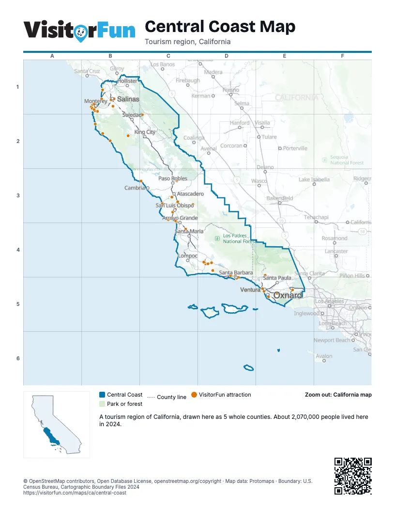
Highway index of Central Coast
Each highway on the sheet and the grid squares it crosses.
- US 101B1, B2, C2, C3, C4, D4, D5, E5
- CA 1B1, C3, C4, E5
- CA 23E5
- CA 33E5
- CA 46C3
- CA 68B1
- CA 118E5
- CA 126E5
- CA 135C4
- CA 156B1
- CA 166C4
- CA 217D4, D5
Things to do on the Central Coast map
- 17-Mile Drive
- Amanzi Hotel
- Best Western Plus Santa Barbara
- Big Sur Lodge
- Bixby Bridge
- Boyd's Tobacco & Elegant Gifts
- Brick Barn Wine Estate
- Bricks & Minifigs San Luis Obispo
- Bruno's Market & Deli
- Cabrillo Inn at the Beach
- Cafe Fina
- Cal Coast Adventures
- California Central Coast
- California Nature Art Museum
- Camarillo Premium Outlets
- Cambria Nursery & Florist
- Cambria Pines Lodge
- Cannery Row
- Cannery Row Antique Mall
- Carmel Mission Basilica
- Carmel Plaza
- Cat Therapy
- Central Coast Scuba
- Central Coast Veterans Memorial Museum
- Central Coast Zoo
- Channel Islands National Park
- Chris' Fishing and Whale Watching
- Chumash Casino Resort
- Circle Bar B Stables
- Condor Express
- Del Monte Center
- Discovery Whale Watch
- Downtown Santa Barbara
- Edgewater Inn & Suites
- Elverhoj Museum of History and Art
- Estrella Warbirds Museum
- Fishwife
- Hearst Castle
- Highline Adventures
- Hotel Buena Vista
- Inn at the Cove
- Island Packers
- Julia Pfeiffer Burns State Park
- Land and Sea Tours
- Links Club
- Little Mermaid Glass Bottom Boat Tours
- Madonna Inn
- Mama's Meatball
- Margarita Adventures
- Mistura
- Monterey Bay Aquarium
- Monterey Bay Eco Tours
- Monterey Bay Equestrian Center
- Monterey Bay Whale Watch
- Monterey Mirror Maze
- Monterey Touring Vehicles
- Monterey Zoo
- Museum of Ventura County Agriculture Museum
- New Frontiers Natural Marketplace
- Nicola
- Nipomo Swapmeet & Fleamarket
- Northridge Mall
- Ojai Valley Museum
- Old Fisherman's Grotto
- Old Fisherman's Wharf
- Pacific Grove Museum of Natural History
- Paso Robles Visitor Center
- Paso Robles Wine Country
- Pea Soup Andersen's Inn
- Pebble Beach Golf Links
- Pinnacles National Park
- Pirate's Cove Beach
- Pismo Beach Premium Outlets
- Pismo Beach Visitor Center
- Point San Luis Lighthouse
- Princess Monterey Whale Watching
- Puzzle Effect
- Ramada by Wyndham Santa Barbara
- Reagan Ranch Center
- Refuge
- Ronald Reagan Presidential Library & Museum
- Rusty's Pizza
- Salinas City Center
- San Luis Obispo Children's Museum
- Sanctuary Cruises
- Santa Barbara Arts & Crafts Show
- Santa Barbara Historical Museum
- Santa Barbara Maritime Museum
- Santa Barbara Museum of Natural History
- Santa Barbara Urban Wine Trail
- Santa Barbara Waterfront
- Santa Barbara Wine Country Cycling Tours
- Santa Barbara Zoo
- Santa Maria Valley
- Santa Ynez Valley Horseback Rides
- Sea Goddess Whale Watching
- SeaCrest OceanFront Hotel
- Sensorio
- Skydive Santa Barbara
- Solvang Visitor Center
- Stardust Sportfishing
- Sub Sea Tours & Kayaks
- Sunburst Railbikes
- The Crossroads Carmel
- The King Frederik Inn
- The Upham Hotel
- US Navy Seabee Museum
- Ventura Harbor Village
- Wheel Fun Rentals Ventura
- Woodland Auto Display
Places on the map
- Arroyo Grande
- Atascadero
- Cambria
- Hollister
- King City
- Lompoc
- Monterey
- Oxnard
- Paso Robles
- Salinas
- San Luis Obispo
- Santa Barbara
- Santa Maria
- Santa Paula
- Soledad
- Ventura
Next to Central Coast
© OpenStreetMap contributors, Open Database License, openstreetmap.org/copyright · Map data: Protomaps · Boundary: U.S. Census Bureau, Cartographic Boundary Files 2024