

California map
Chico map
About 102,911 people live here (Census Bureau, 2024 estimate). The sheet's index lists 300 streets; Esplanade, Cohasset Road and Manzanita Avenue cross the most grid squares. Also on it: 20th Street Community Park, Annie's Glen (Bidwell Park) and Bidwell Junior High School.
Open the map (PDF, US Letter)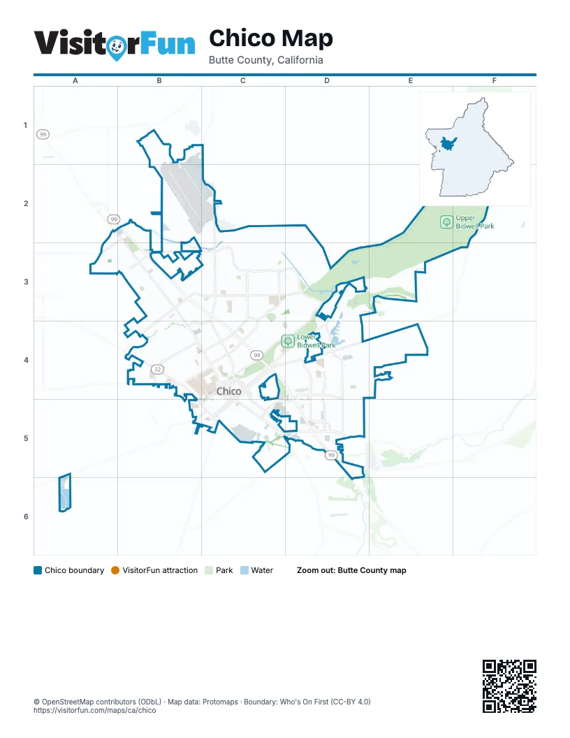
Street index of Chico
Each street on the sheet and the grid squares it crosses.
- Highway 99C4, D4
- East 20th StreetD5, E5
- Deer Creek HighwayD4, E4, F4, D5
- Bruce RoadE4, E5, E6
- East 8th StreetD4, E4, C5, D5
- Nord AvenueB4, B5, C5
- Skyway RoadD6, E6
- Park AvenueC5, D5, D6
- East 9th StreetC5, D5
- West 9th StreetC5
- West 8th StreetC5
- Walnut StreetC5, C6
- Main StreetC5
- East Park AvenueD6
- Oroville AvenueC5
- Eaton RoadC2, B3, C3, D3
- EsplanadeA2, B2, B3, B4, C4, C5
- Cohasset RoadC1, C2, C3, B4, C4
- East AvenueB3, C3, D3, B4
- East 1st AvenueC4, D4
- Mangrove AvenueC4, C5
- West East AvenueB4
- Broadway StreetC5, D5
- Woodland AvenueD4, C5, D5
- Pine StreetC5
- Cypress StreetC5
- MidwayD6
- Longfellow AvenueD4
- Forest AvenueD4, D5, E5, E6
- Notre Dame BoulevardD4, E4, E5, E6
- Manzanita AvenueC3, D3, E3, C4, D4
- Vallombrosa AvenueE3, C4, D4, E4, C5
- Floral AvenueC3, C4
- West Sacramento AvenueB5, C5
- West 8th AvenueB4, C4, B5
- Fair StreetD5, D6, E6
- Salem StreetC5, D5, D6
- Mariposa AvenueD3, D4
- East 5th AvenueC4
- Ivy StreetC5, D6
- West Eaton RoadA3, B3
- West 5th StreetC5
- Marigold AvenueD3
- West 3rd StreetC5
- Chico Canyon RoadE3, E4
- West 4th StreetC5
- Madrone AvenueD3, D4
- West 2nd StreetC5
- Mulberry StreetC5, D5
- Nord HighwayA2, A3
- Dayton RoadC5, C6
- West 1st StreetC5
- East 4th StreetC5
- Centennial AvenueD4, E4
- East 3rd StreetC5
- Fir StreetD4, D5
- Hegan LaneD6
- West 5th AvenueC4
- East 1st StreetC5
- East 2nd StreetC5
- Dominic DriveE6
- Chico River RoadC5
- Upper Park RoadF2, D3, E3, F3
- Humboldt RoadD4, E4, F4, D5
- Springfield DriveD5, E5
- East Lassen AvenueB3, C3
- Esplanade FrontageC4, C5
- West Lindo AvenueB4, C4
- Ceres AvenueC2, C3, C4
- Canyon Oaks TerraceE3, F3
- Filbert AvenueC4, D4
- Shallow Springs TerraceE3, F3, E4
- California Park DriveE3, E4
- Normal AvenueC5, C6, D6
- East Lindo AvenueC4, D4
- Native Oak DriveE4, F4
- Hicks LaneB1, B2, B3
- Ceanothus AvenueD3, D4
- Henshaw AvenueB3, A4, B4
- White AvenueB3, C3, B4
- Oleander AvenueC4, C5
- Degarmo DriveA3, B3
- Yosemite DriveE3, E4
- North AvenueC3, C4
- Hooker Oak AvenueD3, D4
- Humboldt AvenueC5, D5
- Sheridan AvenueC4, D4
- West 12th AvenueB4
- West 11th AvenueB4, C4
- Arbutus AvenueC4, C5
- Marauder StreetC1
- Alamo AvenueB4
- Fortress StreetB1, C1, C2
- Arcadian AvenueB4, C4, C5
- Idyllwild CircleE4
- Palmetto AvenueC4, D4
- Pillsbury RoadC3
- Chestnut StreetC5
- Laburnum AvenueC4
- Citrus AvenueB4, C4, C5
- Doctor Martin Luther King Junior ParkwayD5, D6
- West 7th StreetC5
- Warner StreetB4, C5
- Spruce AvenueC4
- Magnolia AvenueB4, C4, C5
- Palm AvenueC4
- East 7th StreetC5, D5
- Greenwich DriveB4, B5
- Shadybrook LaneE3, F3
- Picholine WayE5
- Cussick AvenueB3, B4
- West 4th AvenueB4, C4, B5
- Burnap AvenueC3
- Rogue River DriveA3
- Stilson Canyon RoadE4, E5
- Rio Lindo AvenueB4, C4
- Neal Dow AvenueC4, D4
- East 16th StreetC5, D5
- Downing AvenueC4, D4
- Invader StreetB1, C1, C2
- Holly AvenueB4
- West 2nd AvenueC4, B5, C5
- West 1st AvenueC4, B5, C5
- Hazel StreetC5
- East 9th AvenueC4
- West 6th StreetC5
- East 3rd AvenueC4
- East 7th AvenueC4
- West 16th StreetC5, C6
- Sierra Sunrise TerraceE4
- Godman AvenueB3
- Cherry StreetC5
- Lupin AvenueC3
- Lakewest DriveE4
- Morrow LaneE6
- Whitewood WayC3, D3
- Oak WayB4, B5
- West Shasta AvenueB3
- West Lassen AvenueB3, B4
- Sequoyah AvenueB4
- Ryan AvenueB1, C1
- Glenshire LaneC3, D3
- Guynn AvenueA4, B4
- East 6th StreetC5
- El Paso WayB3, C3
- Olive StreetC5
- Sherman AvenueC4
- Airpark BoulevardC1
- Orange StreetC5
- Terrace DriveD4
- Cedar StreetC5
- Hawthorne AvenueD4
- West 6th AvenueB4, C4
- Elm StreetD5
- Northwood Commons PlaceB3, B4
- Cactus AvenueD3
- Mission Ranch BoulevardB4
- Glenwood AvenueB4, B5
- Weymouth WayA3, B3
- Modoc DriveD4
- Lucy WayD3
- Gooselake CircleA3, B3
- Windham WayA3
- Concord AvenueE5
- Flume StreetC5
- Pomona AvenueC5, C6
- Laurel StreetC5, D5
- Sunset AvenueC4
- Hobart StreetB4, C5
- Locust StreetC5, D5
- Skymountain CircleD5
- East 5th StreetC5
- East 19th StreetD5
- Oak StreetC5
- Penzance AvenueA3
- Delaney DriveE4
- East 12th StreetC5, D5
- West 12th StreetC5
- Orient StreetC5
- Sycamore DriveB2
- Hemlock StreetC5, D5
- Abbott CircleA3
- Artesia DriveC3, D3
- West 11th StreetC5
- Otterson DriveD6
- Via Mission DriveE5
- Oakdale StreetC5, D5
- East 10th AvenueC4
- East 10th StreetD5
- Summit Ridge TerraceF3
- Peninsula DriveE4
- Calistoga DriveB3
- Potter RoadE5, E6
- Manzanita CourtC4
- Panama AvenueB3
- Piper AvenueB1, C1
- Bar Triangle StreetE5
- Karen DriveD4
- East 15th StreetC5, D5
- Bryant AvenueC4, D4
- Poplar StreetC5
- Southbury LaneA3, B3
- Golf Course RoadE3
- Wall StreetC5
- Brookside DriveE4
- East 18th StreetD5
- Chamberlain RunA3
- Gallatin GatewayC3, D3
- Oasis DriveB1
- San Ramon DriveC3
- Country DriveD6
- Meadow RoadB4
- Mission Serra TerraceB4
- Zinnia DriveB3, C3
- Autumn Gold DriveB3, B4
- Arch WayD3
- Independence CircleB3
- Alder StreetC5, D5
- Troy LaneB3
- Wildwood AvenueD3
- East 2nd AvenueC4
- Rae Creek DriveD3
- East 4th AvenueC4
- East 6th AvenueC4
- East 8th AvenueC4
- Hudson AvenueD3
- Bancroft DriveE5
- Coit Tower WayE4
- West 14th StreetC5
- Wild Oak LaneD4
- Forest Creek CircleD4
- East Sacramento AvenueC4
- Larch StreetD4
- Silver Lake DriveB3
- New Dawn CircleE5
- Overland CourtC5, C6
- Tom Polk AvenueB3, C3
- Sweetwater FallsC3, D3
- Memorial WayC5
- Robailey DriveD5, E5
- Shaker LaneA3
- Talbert DriveD5, E5
- Convair AvenueC1, C2
- Moyer WayB4
- Boeing AvenueC1, C2
- North Cherry StreetB4
- Lakeside Village CommonsE4
- England StreetE5
- Vista Verda AvenueD4
- Sellers WayD6
- North Cedar StreetB5
- Connors AvenueB3, B4
- Morseman AvenueB3, C3
- Park Vista DriveD4
- El Varano WayB3, C3
- Grumman AvenueC1
- Denali DriveB3
- West 15th StreetC5
- Heritage LaneC3, C4
- Meyers StreetD6
- Shari LaneD5
- Camino Sur StreetB2
- Huntington DriveE5
- Tonea WayB3
- Parkhurst StreetE5
- Pebblewood Pines DriveB4
- West 22nd StreetD5, D6
- Manchester RoadC4
- Ruth LaneA2
- Saint Augustine DriveE5
- East 14th StreetC5, D5
- Pinyon Hills DriveE4
- Silver Dollar WayD5
- Running Springs CircleC3
- El Cerrito DriveC3
- Legacy LaneA3, B3
- Devonshire DriveD5, E5
- Mill Creek DriveB3
- Almendia DriveB5
- Stewart AvenueB5, C5
- Moraga DriveC4
- Mountain View AvenueD4
- Linden StreetC5, D5
- Crater Lake DriveB3
- Howard DriveC4, D4
- Bidwell AvenueB5, C5
- Mission Sante Fe CircleB4
- Kern StreetD4
- Moss AvenueD4
- West 18th StreetC5, D5
- Dawncrest DriveE5
- Redwood WayD4
- Oak DriveB3, B4
- West 17th StreetC5, D5
- Sycamore StreetC5, D5
- Lexington DriveC3
- Camino Norte StreetB2
- Burnt Ranch WayA3
- Parmac RoadC4
- Joshua Tree RoadB3
Places on the map
- 20th Street Community Park
- Annie's Glen (Bidwell Park)
- Bidwell Junior High School
- Bidwell Park Golf Course
- California State University, Chico
- Calvary Chapel Chico
- Canyon Oaks Country Club
- Chapman Elementary School
- Chico Air Museum
- Chico Cemetery
- Chico City Hall
- Chico Crossroads
- Chico Gleaners
- Chico Junior High School
- Chico Mall
- Chico Senior High School
- DeGarmo Community Park
- East Avenue Marketplace
- Emma Wilson Elementary School
- Enloe Medical Center
- Enloe Rehabilitation Center
- Fairview High School
- Five Mile
- Game Field 3
- Game Field 6&7
- Garden Villa
- Honey Run Self Storage
- Hooker Oak
- Horseshoe Lake
- Humboldt Park
- La Dolce Piazza
- Lowe's
- Lower Bidwell Park
- Marigold Elementary School
- North Valley Plaza
- Philadelphia Square
- Upper Bidwell Park
© OpenStreetMap contributors, Open Database License, openstreetmap.org/copyright · Map data: Protomaps · Boundary: Who's On First (CC-BY 4.0); Quattroshapes (CC BY 2.0)