

California map
Citrus Heights map
About 86,909 people live here (Census Bureau, 2024 estimate). The sheet's index lists 300 streets; Auburn Boulevard, Dwight D. Eisenhower Highway and Greenback Lane cross the most grid squares. Also on it: Walking Park, Antelope Plaza and Calvary Cemetery.
Open the map (PDF, US Letter)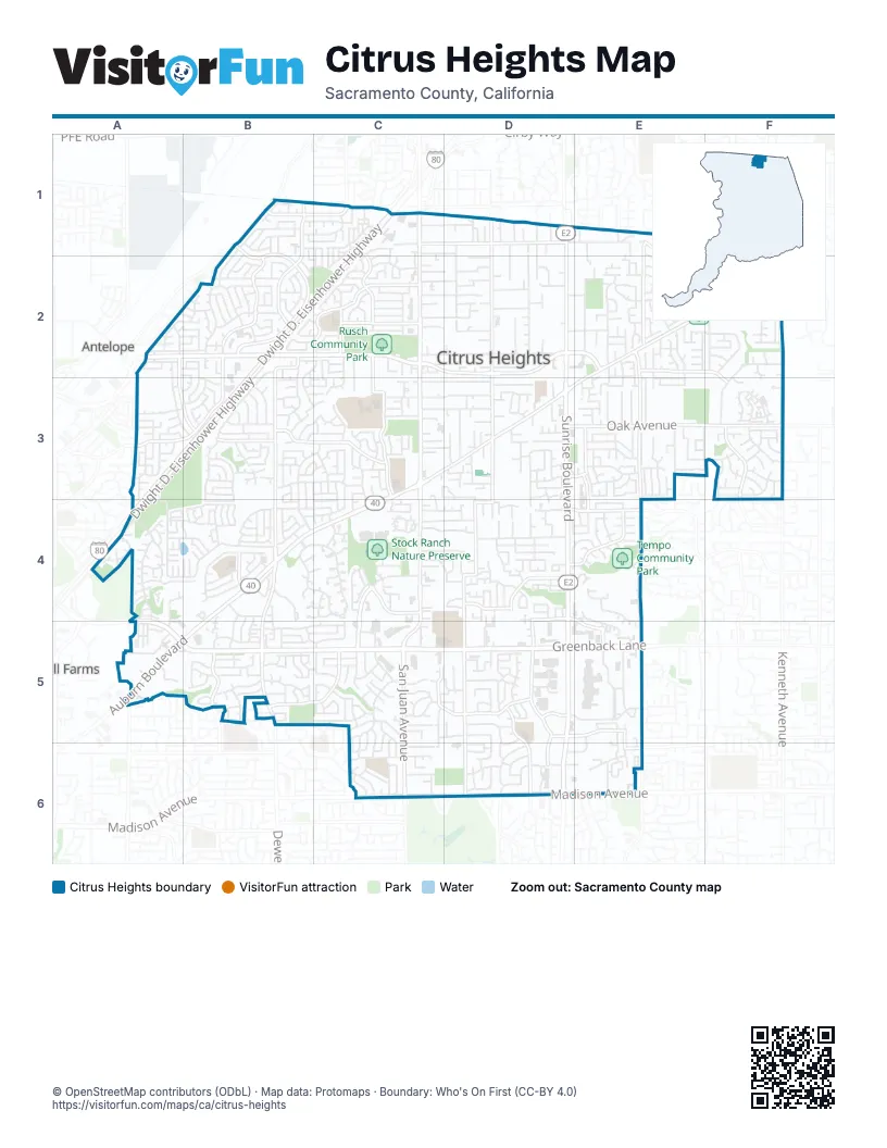
Street index of Citrus Heights
Each street on the sheet and the grid squares it crosses.
- Dwight D. Eisenhower HighwayC1, B2, C2, A3, B3, A4
- Greenback LaneA4, A5, B5, C5, D5, E5
- Sunrise BoulevardD1, D2, D3, D4, D5, D6
- Antelope RoadA2, B2, C2, D2, E2
- Madison AvenueC6, D6, E6
- Auburn BoulevardC1, C2, C3, B4, C4, A5, B5
- Old Auburn RoadF1, E2, F2, C3, D3, E3
- Fair Oaks BoulevardE2, E3, E4, E5, E6
- Van Maren LaneB2, B3, B4, B5
- San Juan AvenueC5, C6
- Oak AvenueD3, E3, F3
- Sylvan RoadC3, C4, C5
- Wachtel WayF2, F3
- Kenneth AvenueF3
- Garden Gate DriveB2, B3
- Dewey DriveB5
- Purslane WayB2, B3
- Manzanita AvenueA5
- Mariposa AvenueD1, D2, D3, D4, D5, D6
- Twin Oaks AvenueC1, D1, E1, E2, F2
- Lichen DriveB1, B2
- Lauppe LaneC2, C3
- Rollingwood BoulevardC2
- Birdcage StreetD4, D5, D6
- Tupelo DriveB2, A3, B3
- Butternut DriveB1, B2
- Kingswood DriveD5, E5, D6
- Farmgate WayC5, D5
- Fountain Square DriveC4, C5
- Zenith DriveB2
- Calvin DriveB3, C3
- Saybrook DriveA2, A3, B3
- Garry Oak DriveE1, E2
- Carriage DriveC3
- Canelo Hills DriveE3
- Primrose DriveD5, D6
- Villa Oak DriveE2, F2, F3
- Larwin DriveD4, E4
- Rusch DriveC1, C2
- Stock Ranch RoadC4
- Whyte AvenueB1, C1
- Old Ranch RoadF3
- Woodmore Oaks DriveD4, E4
- Grand Oaks BoulevardC2
- Sayonara DriveD4
- Rosswood DriveC2
- Brooktree DriveB5, C5
- Misty Creek DriveB3
- Sungarden DriveD3, E3
- Parkoaks DriveB5
- Arcadia DriveD4, E4, E5
- San Simeon DriveD4
- Sun Hill DriveD4
- Dunmore AvenueB5
- Daly AvenueA3
- Halifax StreetB4
- Crux DriveE3, E4
- Celine DriveE5, E6
- Macy Plaza DriveD5
- Vernon StreetC1
- Treecrest AvenueE6
- West Whyte AvenueC1
- Elm AvenueF3
- Oak Lakes LaneA3, A4, B4
- Crosswoods CircleB4, C4
- Imperial Manor MhpA5
- Canyon Oak DriveE2, F2
- Watson WayC2, D2
- Sycamore DriveC3, D3
- Westbrook DriveB4
- Summerplace DriveB2
- Sperry DriveC5, C6
- Navion DriveB2, B3
- Creekridge LaneF3
- Villaview DriveB1, B2
- Verner AvenueA3, A4
- Glen Tree DriveE2, E3
- Patton AvenueD1, D2
- Olivine AvenueF2, F3
- Pratt AvenueC3, D3
- Claypool WayE2, F2
- Cobalt WayB3, C3, B4
- Daisy LaneB4
- Oakcreek WayB5
- Big Oak DriveF2
- Wooddale WayE2, E3
- Highland AvenueD4
- Winlock AvenueB3, C3
- Streng AvenueE3, F3
- Indian River DriveA4, A5
- Eastgate AvenueC5, D5, D6
- Holly DriveD1, D2
- Uplands WayD6
- Parkvale WayA3
- Mercedes AvenueB5, C5
- Bonita WayD3
- Briartree WayB2
- Merlindale DriveD5
- Blackthorne WayA2, A3, B3
- Flaming Arrow DriveA4
- Wonder StreetE2
- Mauana WayD4
- Fair WayD1, D2
- Kilarney LaneC3, D3
- Cook AvenueC3, D3
- Fireweed CircleF3
- Cranford WayF3
- Brookcrest WayC5
- Heritage Meadow LaneE3
- Westgate DriveC5, D5
- Auburn Oaks Village LaneF2
- Carmelwood DriveB2
- West Berry LaneD2
- Outlook DriveB2
- Brayton AvenueB5, C5
- Westchester WayC3, B4, C4
- Amsterdam AvenueC2, B3, C3
- Cedar DriveC2, D2
- Brockwood WayA2, B2
- Talbot WayF2
- Oak Grove AvenueC2, D2
- Glen Alta WayE2
- Huntington Square LaneC4
- Circlet WayB3
- Blue Springs WayB1, C1
- Spicer DriveC5
- Sunrise Vista DriveE5
- Conover DriveF1, F2
- Baird WayC2, D2
- Heritage Tree LaneE6
- Kittery AvenueB4, C4
- Yarrow WayE3
- Trailride WayB4
- Locher WayD4
- Amberwick WayC5
- Windjammer WayA3
- Grenola WayC3
- Oakberry WayC2
- Wintergreen DriveF2
- Sunburst WayB3, B4
- Walnut DriveC2, D2
- Garryanna DriveE2
- Candlelight WayC3
- San Cosme DriveE3
- Thalia WayC4
- Circuit DriveC4, D4
- Mesa Oak WayE2
- Enright DriveB3, C3
- Bremen DriveB5
- Northridge DriveD5
- Menke WayF3
- Woodside DriveC4
- Kingsmills WayF3
- Arcade Creek ManorB4
- Willowleaf DriveB3
- Copperwood DriveE3
- Sylvan Valley WayC4, D4
- Mountainside DriveB1, C1
- Pacheco WayD4
- Alma Mesa WayE3
- Chesline DriveC6
- Oakbrook DriveB5
- Poulson StreetE3
- Raintree DriveC3, C4
- Bonnie Oak WayE1, F1
- Lynnetree WayD3
- Community DriveC4, D4
- Briar Ridge LaneE6
- Gingerblossom DriveB2, C2, B3, C3
- Glen Creek WayE2
- Cross DriveE3
- Greenleaf DriveB5
- Linden AvenueC1, D1
- Chipmunk WayE2, E3
- Cloverleaf WayB1, C1, B2, C2
- Prince StreetC3, D3, D4
- Meadowcreek WayB5
- Spring Valley AvenueD4
- Shadow Hawk DriveA4, B4
- Sandalwood DriveC2
- Mannerly WayB1
- Leonard AvenueD3
- Birdcage Center LaneD5
- Country LaneA5
- Sugar Maple WayD4, E4
- Dana Butte WayE3
- Rubion CircleE6
- Skylane DriveB3
- Trovita WayD4, E4
- Denton WayD4
- Evening WayC2
- Kensington DriveD5
- Viceroy WayD5
- Woodruff WayC1, C2
- Goldenwood CircleA4
- Moss Oak AvenueE1, E2, F2
- Astronaut LaneA4, B4
- Live Oak WayC2, C3
- Baranga DriveC3
- Summerset LaneA4, B4
- Birchglade WayA3, B3
- Saxton CircleC1, C2
- Camden CircleA5
- Gumwood CircleB2, C2
- Mar Vista WayB3
- Saint Philomena WayE3
- Newbridge WayF1, F2
- Lobata StreetE2
- Phoebe WayF2
- Campfire WayB4
- San Tomas DriveC4
- Pau Hanna CircleC1, C2
- Capricorn DriveD6
- Reno LaneD2
- Bix AvenueB5
- North East CircleD6
- Woodlake Hills DriveE4
- Burnham DriveC5
- Brookhaven WayC5
- Park DriveC4, D4
- Coral Oak WayE2
- Declaration CircleA5
- Mansfield DriveF3
- Melva StreetF3
- Woodchuck WayE2, E3
- Spyglass LaneE5, E6
- Chapel View LaneB4, B5
- Gallant CircleC4
- Arcade Lake LaneD4, E4
- Buttonwood WayB2
- Holly Oak StreetE2, F2
- Escallonia DriveF3
- Catamaran DriveA3
- Pippin WayB3, C3, C4
- Maidstone WayC6
- Chipping WayC5, C6
- Oak Forest StreetC2
- Berman Walk WayF2
- Convair WayB3
- Wildwood WayD6
- Oakwood Hills CircleF1, F2
- Stone Canyon CircleE4
- Hanson AvenueD2, E2
- Canevalley CircleB1, C1
- Donegal DriveB4
- Dolan WayB3, C3
- Rinconada DriveD4
- Sunrise East WayE5
- Matheny WayA4, B4, A5
- Stonehand AvenueA2, B2
- Creekmont WayB3
- Ventana PlaceE6
- Pintail CircleA3
- Southgrove DriveC5, C6
- Almondwood AvenueC4, D4
- Hidden Brook LaneB4
- Lesser WayC2
- Peoria DriveC5
- Ramblewood WayB2
- Aspen Gardens WayC4
- Sunmist WayB3, B4
- Rosa Vista AvenueD4
- Jonquil WayF3
- Alta Vista LaneE6
- Stacey Hills DriveE3
- Olive Tree WayE4
- Larkspur AvenueD3, D4
- Linda Sue WayC6
- Woodglade AvenueA2
- Sun Terrace WayE2
- Auburn Oaks CourtC1
- Fleetwood DriveC6
- Pinecreek WayA2, B2, A3, B3
- Birchwood CircleB2
- Guenivere WayD5
- Wickham DriveD3
- Monteverde LaneC4
- Tall River DriveD4
- Somersworth DriveB4
- Tallwood CircleC1
- Bierstan StreetB2, B3
- Chula Vista DriveD4
- Greenbrook CircleC5
- Nelson LaneD3
- Longford DriveB4, B5
- Avalos WayF2
- Glenhurst WayA3, B3
- Lee DriveD1, D2
- Saint Ives LaneB4
- Shupe DriveC5
- Loleta AvenueD2
- Pleides AvenueD6
- Cheltenham WayB4
- Glenn AvenueD2
- Le Havre WayB5, C5
- Radiance CircleA4
- Mallard LaneA3
- Red Maple WayE4
- Wexford CircleB4
- Kanai AvenueC3
Places on the map
- 7-Eleven
- ampm
- Antelope Plaza
- Antelope Post Office
- Applebee's
- Arcade Creek Park Preserve
- B Liquor
- Bank of America
- Bauer's Full Service Car Wash
- Best Buy
- Brooktree Park
- Bubba's Car Wash
- C-Bar-C Park
- Calvary Cemetery
- Cambridge Heights Elementary School
- Capital Transmission
- Carl's Jr.
- Carolina's Mexican Grill
- Carriage Drive Elementary School
- Chase
- Cherry Creek Manor Park
- Foothill Golf Course
- Grand Oaks Elementary School
- Indian River Drive Open Space
- Madera Park
- Mesa Verde High School
- Rusch Community Park
- San Juan High School
- San Juan Park
- Shadowcreek Open Space
- Stock Ranch Nature Preserve
- Summer Hills Plaza
- Sunrise Mall
- Sylvan Cemetery
- Sylvan Middle School
- Tempo Community Park
- Twin Creeks Open Space
- Van Maren Park
- Walking Park
- Westwood Park
Next to Citrus Heights
- Antelope
- Foothill Farms
© OpenStreetMap contributors, Open Database License, openstreetmap.org/copyright · Map data: Protomaps · Boundary: Who's On First (CC-BY 4.0); Quattroshapes (CC BY 2.0)















