

California map
Sacramento County map
About 1,611,231 people live here (Census Bureau, 2024 estimate). The sheet's index lists 9 streets; Golden State Highway, Westside Freeway and El Dorado Freeway cross the most grid squares. Things to do inside the boundary: Isleton Asian American Heritage Park, MOSAC (SMUD Museum of Science and Curiosity) and The California Museum.
Open the map (PDF, US Letter)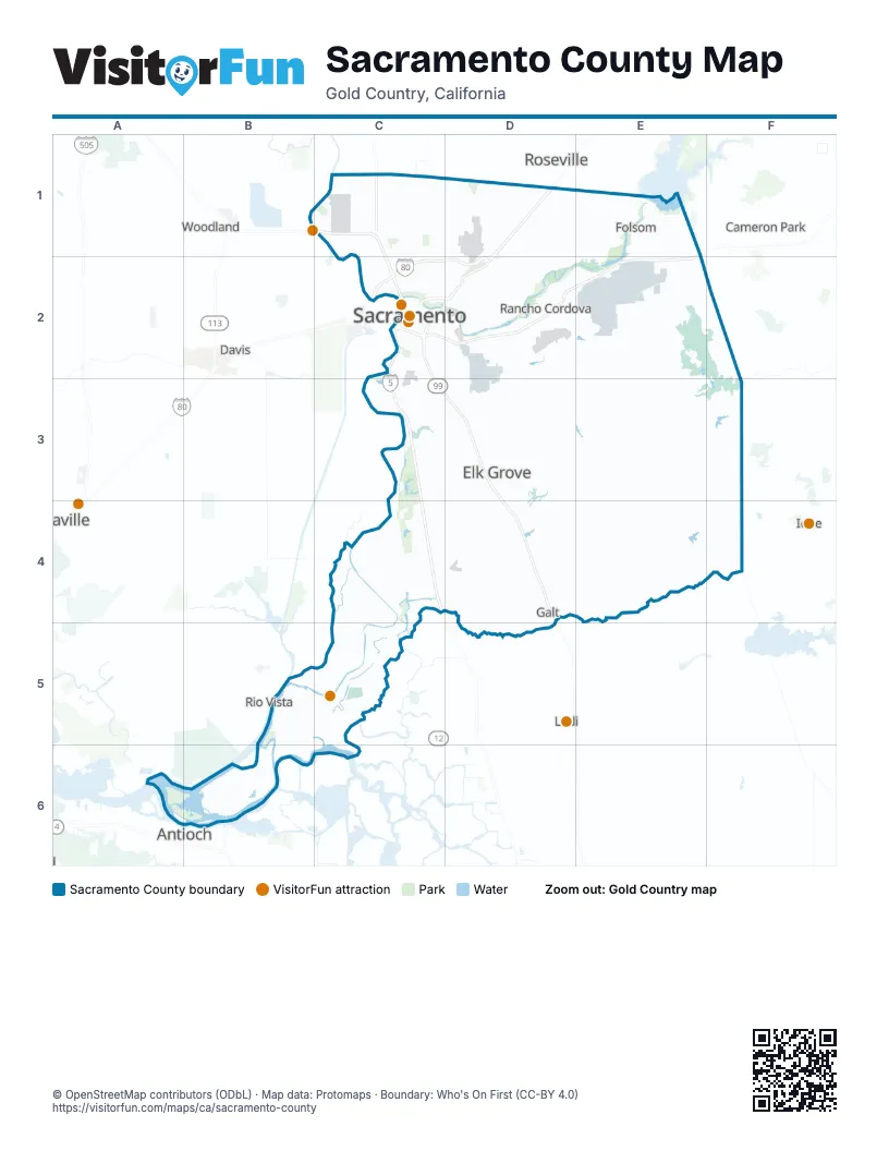
Maps inside Sacramento County
1 map inside, from the street map of Sacramento County down.
Street index of Sacramento County
Each street on the sheet and the grid squares it crosses.
- Golden State HighwayC1, C2, C3, D3, D4
- Westside FreewayC1, C2, C3, C4
- Capital City FreewayD1, C2, D2
- Dwight D. Eisenhower HighwayD1
- North Sacramento Beltline FreewayD1, C2, D2
- El Dorado FreewayE1, C2, D2, E2
- Route 50E1
- North Sacramento FreewayC2, D2
- South Sacramento FreewayC2, D4
Things to do on the Sacramento County map
Places on the map
- Aerojet Rocketdyne Site
- Air Cargo Apron
- Alhambra Triangle
- Alkali Flat
- American River Canyon Drive
- American River Parkway
- Anatolia Village
- Ancil Hoffman Golf Course
- Arcade Creek forest
- Arden Fair Mall
- Arden-Arcade
- Avondale
- Barrett Ranch
- Belvedere
- Bing Maloney Golf Club
- Blodgett Reservoir
- Boulevard Park
- Brentwood
- Broad Slough
- Cal Expo
- Camden Park
- Campus Commons
- Carleton Tract
- Carmichael
- Central Oak Park
- Cherry Island Golf Course
- Citrus Heights
- Clay
- College Town
- College/Glen
- Colonial Heights
- Colonial Manor
- Colonial Village
- Curtis Park
- Deer Creek Hills Preserve
- Del Paso Park
- Delta Meadows
- Delta Shores
- Depot Park
- Downtown
Next to Sacramento County
- Antioch
- Cameron Park
- Davis
- Ione
- Lodi
- Pittsburg
- Rio Vista
- Roseville
- Vacaville
- Woodland
© OpenStreetMap contributors (ODbL) · Map data: Protomaps · Boundary: Who's On First (CC-BY 4.0)