

California map
Del Norte County map
About 27,009 people live here (Census Bureau, 2024 estimate). The sheet's index lists 300 streets; Redwood Highway, Gasquet-Orleans Road and Elk Valley Road cross the most grid squares. Things to do inside the boundary: Trees of Mystery, Lucky 7 Casino and Ocean World.
Open the map (PDF, US Letter)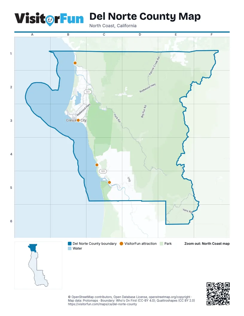
Street index of Del Norte County
Each street on the sheet and the grid squares it crosses.
- Redwood HighwayE1, C2, D2, E2, B3, C3, C4, C5
- L StreetB3
- M StreetB3
- Collier TunnelE1
- Lake Earl DriveB2, C2, B3
- North Bank RoadC2, C3
- Northcrest DriveB3
- East Washington BoulevardB3
- Requa RoadC5
- Happy Camp RoadF1
- Newton B Drury Scenic ParkwayC5
- Gasquet-Orleans RoadD4, E4, D5, E5, F5, F6
- Bluff Creek RoadE5, F5, E6
- South Fork RoadC3, D3, D4
- Patrick Creek RoadD1, E1, D2
- Elk Valley RoadB3, C3, E4, E5
- Ocean View DriveB1
- Klamath Beach RoadC5
- Parkway DriveB3, C3
- South Fred D Haight DriveC2
- Klamath Glen RoadC5
- West Washington BoulevardB3
- Elk Valley Cross RoadB2, B3, C3
- North Pebble Beach DriveB3
- Inyo StreetB3
- South Pebble Beach DriveB3
- Pacific AvenueB3
- 5th StreetB3
- 9th StreetB3
- Wimer RoadE1
- H StreetB3
- Cooper AvenueB3
- Meridian StreetB3
- East Cooper AvenueB3
- North Fred D Haight DriveC1, C2
- Taylor StreetB3
- West 9th StreetB3
- West 5th StreetB3
- Low Divide RoadC1, D1, C2
- Red Mountain RoadD4, C5, D5
- Ship Mountain RoadE2, D3, E3, D4
- Big Flat RoadD2, D3, D4
- Old Gasquet Toll RoadD2
- Knopki Creek RoadE1, E2
- French Hill RoadC2, D2
- Bear Basin RoadD2, E2, E3
- Holiday RoadD1, D2
- Gasquet Mountain RoadC2
- Oregon Mountain RoadE1
- Laird Meadow RoadE6
- Howland Hill RoadB3, C3
- Vans RoadE6
- Forest Road 17N05D2, E2
- Meadow RoadD5
- Rowdy Creek RoadC1, C2
- Lower Lake RoadB2
- Kings Valley RoadB2, C2, C3
- Forest Route 17N08D2
- U10D5
- Wilson Creek RoadC4
- Tell BoulevardB2
- Cedar Camp RoadE6, F6
- South Bank RoadC2
- Alder Camp RoadC5
- Hunter Creek RoadC4, C5
- Railroad AvenueB2, B3
- Rock Creek RoadE5
- Wonder Stump RoadB2, C2
- Hamilton RoadC3
- Shavely RoadC1, C2
- Old South Fork HighwayC2
- Coastal DriveC5
- Enderts Beach RoadB3, C3
- Obrien-Elk Valley RoadE2
- U400 RoadD5
- Horse Creek RoadD4
- Bailey RoadB2, C2
- Prigmore StreetB2
- Porteck StreetB2
- Moorehead RoadB2
- Placone StreetB2
- Joaquin StreetB3
- Gasquet Flat RoadC2, D2
- Moseley RoadB2, C2
- Walker RoadC2
- Humboldt RoadB3
- Old Mill RoadB3
- Rellim RoadC2
- Patrick J Murphy Memorial DriveC5
- Valentine StreetB2
- Martin StreetB2
- Dunn Creek RoadF1
- Kellogg RoadB2
- Muslatt Mountain RoadD4
- Blackwell LaneB3
- Douglas Park DriveC3
- Southeast Klamath Beach RoadC5
- Ocean DriveB2
- Alder Camp Loop RoadC5
- RM300 RoadD5
- Spyglass RoadB1
- Cemetery RoadB3
- Sarina RoadB2
- Shadow LaneB1
- Radio RoadB3
- State Line LaneB1
- Bertsch StreetB3, C3
- Shutt StreetB2
- Ramey StreetB2
- Peacock RoadC2
- Sanders RoadC4
- First StreetB2, C2
- Klamath Mill RoadC5
- Powerline RoadB2
- Bolan Lake RoadF1
- Stukey StreetB2
- Pala RoadB2
- Terwer Riffle RoadC5
- A StreetB3
- Riverside StreetB3
- B StreetB3
- Middleton DriveB2
- Lauff AvenueB3
- Lakeview RoadB2, B3
- Vergine DriveB2
- 3rd StreetB3
- Nemeth StreetB2
- Tan Oak DriveC2
- El Dorado StreetB3
- Marish StreetB2
- Bell Hole LoopC2
- Macken AvenueB3
- Hinckley DriveB2
- Cloutier StreetB2
- Pacomo Camp DriveC3
- Fisher DriveB2
- Terwer Valley RoadC5
- Carson DriveB2
- Glenn StreetB3
- Madison AvenueB3
- North Fork RoadD2
- Mc Millian RoadC5
- Mud Hen Village RoadB2
- Front StreetB3
- 4th StreetB1, B3
- Darby StreetB3
- Murphy AvenueB3
- Anchor WayB3
- Klamath BoulevardC5
- South Indian RoadB1
- Ashford RoadC3
- Redwood RoadC5
- West Jefferson StreetB3
- Distelrath DriveB2
- Debacker RoadC5
- Ginny LaneC2
- 7th StreetB3
- 8th StreetB3
- Childs AvenueB3
- North West Brook LaneB1
- G StreetB3
- Church Tree RoadC3
- K StreetB3
- State StreetB3
- Malone RoadB3
- Hyatt HeightsC3
- E StreetB3
- Boulder AvenueB3
- McNamara AvenueB3
- Borough LaneC2
- Aubell LaneB3, C3
- Compass CourtB1
- Ocean Heights WayB1
- 2nd StreetB3
- Wilson LaneC2
- Alder RoadB3
- J StreetB3
- Vipond DriveB3
- California StreetB3
- Minot Creek RoadC5
- Ship Mountain Lookout RoadE3
- Oregon StreetB3
- Pine Grove RoadB3
- 6th StreetB3
- Cummins LaneB3
- Sandman RoadB3
- Carole LaneB3
- De Mars DriveB2
- Boomer LaneB2
- Ruiz Canyon DriveC2
- Mountain View DriveC2
- Keller AvenueB3
- Summer LaneB3
- Dundas RoadB3
- South Kraft RoadC2
- Buzzini RoadB2
- Cunningham LaneB3
- Kerby StreetB3
- Beech StreetB3
- Frontage RoadB3, C3
- Coburn RoadD3, D4
- Sand Hill RoadB3
- Butte StreetB3
- Surf DriveB2
- Fresno StreetB3
- Sarina Road NorthB1, B2
- I StreetB3
- Breen StreetB3
- D StreetB3
- Downing StreetB3
- Howe DriveB3
- Trinity WayC5
- Harrold StreetB3
- Malaney DriveB3
- Shirley StreetB3
- Napa StreetB3
- Olive StreetB3
- Temple StreetB3
- Waldo StreetB3
- Barker StreetB3
- Sunrise LaneB3
- Jed Smith LaneC2
- Turnbull LaneB2, C2, B3
- Sierra Wood RoadC2
- Peine RoadC5
- McNamara RoadB3
- Modoc StreetB3
- Rossini LaneC2
- Gainard StreetB3
- Wheeler LaneB2, C2
- Elk Creek RoadB3
- Oliver AvenueB3, C3
- Peveler AvenueB3, C3
- Quinlan AvenueB3, C3
- Roy AvenueB3, C3
- Humboldt StreetB3
- North Fork LoopD2
- Del Norte StreetB3
- Lakeside LoopB3
- C StreetB3
- F StreetB3
- Le Clair AvenueB3, C3
- Maher AvenueB3, C3
- Movie LaneB2, B3
- White LaneB2
- Hobbs Wall RoadB3
- Nepeuy RoadC5
- Club DriveC2
- Cessna DriveB3
- East Hoover AvenueB3
- East Coolidge AvenueB3
- Airport RoadB3
- Arrow Mill RoadC5
- Azalea LaneD2
- Silva RoadB2
- Norris AveB3
- Nickel AvenueB3, C3
- Village DriveB3
- Reddy AvenueB3
- Bolen LaneB2
- Mouth of Klamath RoadC5
- Douglas StreetB3
- Lynch RoadB3
- Holben RoadB3
- Pike StreetB3
- Amador StreetB3
- Pelican Beach VistaB1
- Knutsen LaneC2
- Mouth of Smith River RoadB1
- Westbrook LaneB1, B2
- Winding Creek CircleB3
- Ferndale LaneB3
- Isabella RoadB3
- Arlington DriveB3
- El Monte RoadB3
- Evergreen LaneB3
- Del Mar RoadB3
- Morrison LaneC2
- Skycrest DriveB2
- Purdy LaneB2, C2
- West Adams AvenueB3
- Sultan Creek RoadC2
- Fern LaneB3
- Rose LaneC2
- Earl StreetB2
- East Jefferson StreetB3
- Shoreline DriveB1
- Capitol StreetB3
- Lesina RoadC3
- Wendell StreetB3
- Surfsound CourtB1
- Scenic Creek DriveB3
- Star Trek DriveB2, C2
- Aile LaneB2
- Rain Tree RoadC3
- English LaneC3
- Burtschell StreetB3
- Sorrel Ridge RoadB2
- Calaveras StreetB3
- Charm LaneB3
Things to do on the Del Norte County map
Places on the map
- Beach Front Park
- Bertsch-Oceanview
- California Coastal National Monument
- Castle Rock
- Castle Rock Special Closure
- Crescent Beach
- Crescent City
- Crescent City-Redwoods KOA
- Dead Lake
- Del Norte Coast Redwoods State Park
- Del Norte Golf Course
- Elk Valley Rancheria / T'uu-nes dee-ni'
- Fort Dick
- Gasquet
- Hiouchi
- Jedediah Smith Campground
- Jedediah Smith Redwoods State Park
- Klamath
- Klamath Camper Corral
- Lagoon Pond
- Lake Earl
- Lake Tolowa
- Mill Creek Campground
- Panther Flat Campground
- Pebble Beach
- Pelican Bay State Prison
- Pelican State Beach
- Point St. George Reef Offshore State Marine Conservation Area
- Prince Island
- Redwood Heritage State Wilderness
- Redwood Meadows RV Park
- Redwood National and State Parks
- Redwood National Park
- Siskiyou Wilderness
- Smith River
- Smith River National Recreation Area
- Tillas Island
- Tolowa Dee-ni' Nation
- Tolowa Dunes State Park
- Yontocket Slough
© OpenStreetMap contributors, Open Database License, openstreetmap.org/copyright · Map data: Protomaps · Boundary: Who's On First (CC-BY 4.0); Quattroshapes (CC BY 2.0)















