

California map
California map
Things to do inside the boundary: 17-Mile Drive, Academy Museum of Motion Pictures and Adventure in Camping. Also on it: American River Parkway, Angeles National Forest and Auburn State Recreation Area. Just past the edge: Bullhead City, Carson City and Cedar City.
Open the map (PDF, US Letter)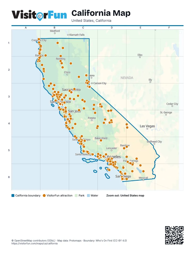
Maps inside California
27 maps inside, from the street map of California down.
Counties
- Alameda County2 inside
- Contra Costa County
- Fresno County1 inside
- Kern County1 inside
- Los Angeles County3 inside
- Marin County
- Merced County
- Monterey County
- Orange County3 inside
- Placer County
- Riverside County2 inside
- Sacramento County1 inside
- San Bernardino County2 inside
- San Diego County2 inside
- San Joaquin County1 inside
- San Luis Obispo County
- San Mateo County
- Santa Barbara County
- Santa Clara County1 inside
- Santa Cruz County
- Solano County
- Sonoma County
- Stanislaus County1 inside
- Tulare County
- Ventura County
- Yolo County
City
Things to do on the California map
- 17-Mile Drive
- Academy Museum of Motion Pictures
- Adventure in Camping
- Agua Caliente Cultural Museum
- Alabama Hills
- Alcatraz Island
- Alpine Slide at Magic Mountain
- Amanzi Hotel
- American Bookbinders Museum
- Amoeba Music Hollywood
- Anaheim
- Anaheim Topgolf Swing Suite
- Ancient Bristlecone Pine Forest
- Anderson Valley
- Anderson's Bicycle Rental
- Angel Island State Park
- Angels Flight Railway
- Anza-Borrego Desert State Park
- Aqua Surf School
- Aquarium of the Pacific
- Arcata Plaza
- Asian Art Museum
- Avenue of the Giants
- Badwater Basin
- Bakersfield
- Balboa Park
- Bazaar Del Mundo
- Beach RV Pleasure Point
- Bear River Casino Resort
- Belmont Park
- Bembridge House
- Berkeley
- Best Western Plus Santa Barbara
- Big Bear Lake
- Big Bear Snow Play
- Big Blue Photo Boat
- Big Bus Tours San Francisco
- Big Sur Lodge
- Bike & View
- Birch Aquarium at Scripps
- Bishop
- Bixby Bridge
- Blazing Saddles Bike Rentals and Tours
- Blue & Gold Fleet
- Blue Ox Millworks & Historic Park
- Boat Tahoe
- Bodega Bay
- Boyd's Tobacco & Elegant Gifts
- Breathless Sparkling Wines
- Brick Barn Wine Estate
- Bricks & Minifigs Redding
- Bricks & Minifigs San Luis Obispo
- Broken Yolk Cafe
- Bruno's Market & Deli
- Buellton
- Buena Vista Museum of Natural History & Science
- Cabazon Dinosaurs
- Cabazon Outlets
- Cabrillo Inn at the Beach
- Cabrillo National Monument
- Cafe Fina
- Cal Coast Adventures
- Calaveras County
- Calico Ghost Town
- California Central Coast
- California Nature Art Museum
- California Parasail Catalina Island
- California Watersports
- California Welcome Center Eureka
- Calistoga
- Camarillo
- Camarillo Premium Outlets
- Cambria Nursery & Florist
- Cambria Pines Lodge
- Camp Richardson Corral
- Cannery Row
- Cannery Row Antique Mall
- Capitola
- Capt. Dave's Dolphin & Whale Watching Safari
- Carlsbad
- Carmel Mission Basilica
- Carmel Plaza
- Carmel-by-the-Sea
- Casa de Bandini
- Cat Therapy
- Catalina Adventure Tours
- Catalina Express
- Catalina Flyer
- Catalina Island
- Catalina Island Horseback Adventures
- Catalina Museum for Art & History
- Catalina Sea Spa
- Catalina Tour Guide
- Central Coast Scuba
- Central Coast Veterans Memorial Museum
- Central Coast Zoo
- Channel Islands National Park
- Chapman's Gem and Mineral
- Charles M. Schulz Museum
- Chateau Marmont
- Children's Museum of Sonoma County
- Chinatown
- Chris' Fishing and Whale Watching
- Chumash Casino Resort
- Ciné Café
- Circle Bar B Stables
- Citadel Outlets
- City Cruises San Francisco
- Classic Club
- Club Ed Surf School and Camps
- Coit Tower
- Coldstream Adventures
- Condor Express
- Confusion Hill
- Courtyard by Marriott Santa Cruz
- Covered Wagon Tours
- Cruise San Diego
- Cruise Tahoe
- Crypto.com Arena
- Dana Wharf Sportfishing
- Dandelion Chocolate
- de Young Museum
- Death Valley National Park
- Del Monte Center
- Dick Taylor Craft Chocolate
- Discount Tickets & Tours
- Discovery Whale Watch
- Disneyland Park
- Dodger Stadium
- Dolby Theatre
- Doobie Nights
- Downtown Berkeley
- Downtown Santa Barbara
- Downtown Santa Cruz
- Dry Creek Vineyard
- Edgewater Inn & Suites
- Efoil Tahoe
- Elverhoj Museum of History and Art
- Emerald Bay State Park
- Empeiria High Sierra Hotel
- Eric's on the Pier
- Escape Room Palm Springs
- Estrella Warbirds Museum
- Exploratorium
- Explore Tahoe Visitor Center
- Far West Fungi
- Fern Canyon
- Ferndale
- Ferry Building
- Fiesta de Reyes
- Filoli
- Fish Hopper
- Fishetarian Fish Market
- Fishwife
- Five Star Adventures Tours
- Footloose Sports
- Fortuna
- Garrod Farms
- Gaslamp BBQ
- Gaumer's Jewelry & Museum
- General Patton Memorial Museum
- General Sherman Tree
- Getty Villa
- Ghirardelli Square
- Gilroy
- Glenmore Plaza Hotel
- Godfather Crime Tour
- Golden Gate Bridge
- Golden Haven Hot Springs Spa
- Golf N' Stuff
- Grace Cathedral
- Grand Central Market
- Gray Line San Francisco
- Greek Theatre
- Griffith Observatory
- Haight-Ashbury
- Half Moon Bay
- Haunted Catalina Ghost Tour
- Healdsburg Chamber of Commerce & Visitors Bureau
- Hearst Castle
- Highline Adventures
- Highway 94 Wine Trail
- Hilmar Cheese Visitor Center
- Hollywood Bowl
- Hollywood Bus Tours
- Hollywood Pantages Theatre
- Hollywood Sign
- Hollywood Walk of Fame
- Hotel Buena Vista
- Hotel del Coronado
- Hotel Metropole
- Humboldt Bay National Wildlife Refuge
- Huntington Beach
- Immersed Catalina
- Indian Canyons
- Inn at the Cove
- International Spy Shop
- Intrepid Escape Rooms
- Island Packers
- Island Water Charters Parasailing
- Isleton Asian American Heritage Park
- Jelly Belly Visitor Center
- Joshua Tree National Park
- Julia Pfeiffer Burns State Park
- June Mountain Ski Area
- Kenwood
- Kings Canyon National Park
- Knott's Berry Farm
- La Brea Tar Pits
- La Jolla Cove
- Lady Bird Johnson Grove
- Laguna Beach Visitors Center
- Lake County Chamber of Commerce and Visitors Center
- Lake Shasta Caverns
- Land and Sea Tours
- Lassen Volcanic National Park
- Liberty Public Market
- Links Club
- Little Mermaid Glass Bottom Boat Tours
- Local Tastes of the City Tours
- Lodi
- Lombard Street
- Lompoc
- Los Angeles
- Los Angeles County Museum of Art (LACMA)
- Los Gatos
- Lucky 7 Casino
- Lyon Air Museum
- M/V Madaket Harbor Cruise
- Madonna Inn
- Mama's Meatball
- Mammoth Lakes
- Mammoth Mountain
- Manzanar National Historic Site
- Margarita Adventures
- Marin County
- Maritime Museum of San Diego
- Maverick Helicopters Long Beach
- Melrose Trading Post
- Mendocino Coast Botanical Gardens
- Mendocino County Tourism Commission
- Mission San Juan Capistrano
- Mistura
- Mono County
- Monterey Bay Aquarium
- Monterey Bay Eco Tours
- Monterey Bay Equestrian Center
- Monterey Bay Whale Watch
- Monterey Mirror Maze
- Monterey Touring Vehicles
- Monterey Zoo
- Morgan Hill
- Morgan Hill Wine Trolley
- MOSAC (SMUD Museum of Science and Curiosity)
- Mount Shasta
- Mount Whitney
- Muir Woods National Monument
- Murrieta
- Museum of Make Believe
- Museum of Making Music
- Museum of Ventura County Agriculture Museum
- Museums of Lake County
- Mystery Spot
- Napa Valley
- Navy SEAL Museum San Diego
- New Frontiers Natural Marketplace
- Newport Beach
- Newport Landing Whale Watching
- Nicola
- Nipomo Swapmeet & Fleamarket
- North Lake Tahoe Boat Rental
- North Tahoe Regional Park
- Oakland
- Ocean World
- Oceanside
- Oceanside Adventures
- Ojai Valley Museum
- Old Fisherman's Grotto
- Old Fisherman's Wharf
- Old Pasadena
- Old Town Eureka
- Old Town San Diego
- Old Town San Diego State Historic Park
- Old Town Trolley Tours of San Diego
- Old Town Trolley Tours San Diego
- Olvera Street
- Oracle Park
- Original Farmers Market & The Grove
- Oxnard
- Pacific Grove
- Pacific Grove Museum of Natural History
- Pacific Park
- Pacific Pinball Museum
- Painted Ladies
- Palace of Fine Arts
- Palisades Tahoe
- Palm Springs
- Palm Springs Aerial Tramway
- Palm Springs Air Museum
- Palm Springs Art Museum
- Paramount Studio Tour
- Pasadena
- Paso Robles Visitor Center
- Paso Robles Wine Country
- Pea Soup Andersen's Inn
- Pebble Beach Golf Links
- Petaluma
- Petco Park Tour
- Petersen Automotive Museum
- Pier 39
- Pine Nut E-Bike Rentals
- Pinnacles National Park
- Pirate's Cove Beach
- Pirates Dinner Adventure
- Pismo Beach Premium Outlets
- Pismo Beach Visitor Center
- Placer Valley
- Point Reyes National Seashore
- Point San Luis Lighthouse
- Powder House Ski & Snowboard
- Princess Monterey Whale Watching
- Puzzle Effect
- Rail Explorers Amador Division
- Rainbow Pack Outfitters
- Ramada by Wyndham Santa Barbara
- Reagan Ranch Center
- Red and White Fleet
- Red Jeep Tours by Desert Adventures
- Redding
- Redding Public Market
- Redwood Creek Buckarettes
- Redwood National and State Parks
- Refuge
- Reggae on the River
- Richard Nixon Presidential Library and Museum
- Ride California
- Ringer's Roller Rink
- Ripley's Believe It or Not Hollywood
- Ripley's Believe It or Not! San Francisco
- River Fox Train
- Roaring Camp Railroads
- Rodeo Drive
- Rohnert Park
- Ronald Reagan Presidential Library & Museum
- Rose Bowl Stadium
- Rowland Freedom Center
- Russian River Rail Bikes
- Rusty's Pizza
- Salinas City Center
- Salvation Mountain
- Samoa Cookhouse
- San Diego
- San Diego Model Railroad Museum
- San Diego Natural History Museum
- San Diego Watercolor Society Gallery
- San Diego Whale Watch
- San Diego Zoo
- San Diego Zoo Safari Park
- San Francisco Bay Ferry
- San Francisco Cable Cars
- San Francisco City Guides
- San Francisco Deluxe Tours
- San Francisco Historical Society
- San Francisco Museum of Modern Art
- San Francisco Railway Museum
- San Francisco Whale Tours
- San Francisco Zoo & Gardens
- San Juan Bautista
- San Luis Obispo
- San Luis Obispo Children's Museum
- San Luis Obispo County
- San Mateo County
- Sanctuary Cruises
- Santa Ana
- Santa Barbara Arts & Crafts Show
- Santa Barbara Historical Museum
- Santa Barbara Maritime Museum
- Santa Barbara Museum of Natural History
- Santa Barbara Urban Wine Trail
- Santa Barbara Waterfront
- Santa Barbara Wine Country Cycling Tours
- Santa Barbara Zoo
- Santa Clara
- Santa Cruz Beach Boardwalk
- Santa Cruz County
- Santa Maria Valley
- Santa Monica
- Santa Monica Pier
- Santa Rosa
- Santa Ynez Valley
- Santa Ynez Valley Horseback Rides
- Santana Row
- Sausalito
- Sea Goddess Whale Watching
- SeaCrest OceanFront Hotel
- SeaWorld San Diego
- Sensorio
- Sequoia National Park
- Sequoia Park Zoo
- Sequoia Tourism Council
- Shadowbrook Restaurant
- Shasta Cascade
- Sierra County
- Sierra Valley
- Sierra Vista Scenic Byway
- Simco Restaurants
- Siskiyou County
- Six Rivers Rafting
- Skunk Train
- Skydive Santa Barbara
- SoFi Stadium
- Solvang Visitor Center
- Sonoma
- Sonoma Canopy Tours
- Sonoma County
- Sonoma County Farm Trails
- Southern Humboldt
- Spanish Village Art Center
- Splash-n-Dash Aqua Park
- Spreckels Performing Arts Center
- Stanford University
- Stardust Sportfishing
- Stretchy Pants Food Tours
- Sub Sea Tours & Kayaks
- Sue-meg State Park
- Sunburst Railbikes
- Sunset Strip
- SUP Tahoe
- Surf Diva
- Tahoe Adventure Company
- Tahoe Bleu Wave
- Tahoe Club Crawl
- Tahoe Dave's Skis & Boards
- Tahoe Gal
- Tahoe Helicopters
- Tahoe Party Boat
- Tahoe Snowmobiles & Tubing
- Tahoe Sport Fishing
- Tahoe Sports
- Tahoe Tastings
- Tahoe Trout Farm
- Tahoe WakeBusters
- Tahquitz Canyon
- TCL Chinese Theatre
- Temecula Valley
- Temecula Valley Wine Country
- The Best Day Spa
- The Beverly Hills Hotel
- The Broad
- The California Museum
- The Comedy Store
- The Crossroads Carmel
- The Fillmore
- The French Laundry
- The Getty Center
- The Hotel Carmel
- The Huntington Library, Art Museum, and Botanical Gardens
- The Intel Museum
- The King Frederik Inn
- The Old Globe Theatre
- The Outlets at Barstow
- The Psychic Gallery
- The Queen Mary
- The Shops at Heavenly Village
- The Ski Renter
- The Spa Art
- The Upham Hotel
- The Walt Disney Family Museum
- Trapped in Tahoe
- Trees of Mystery
- Tri-Valley
- Trinidad State Beach
- Truhlsen-Marmor Museum of the Eye
- Tulare Outlet Center
- Tuolumne County
- UC Santa Cruz Arboretum and Botanic Garden
- Union Square
- Universal Studios Hollywood
- US Navy Seabee Museum
- USS Midway Museum
- USS Pampanito
- Venice Beach Boardwalk
- Ventura
- Ventura Harbor Village
- Visit Buena Park
- Visit California
- Visit Simi Valley
- Visit Vallejo
- Visit Visalia
- Walnut Creek
- Walt Disney Concert Hall
- Warner Bros. Studio Tour Hollywood
- Watts Towers
- Weekend Outside
- Whaley House Museum
- Wheel Fun Rentals Ventura
- Whisky a Go Go
- Wild Cat Education And Conservation Fund
- Wild Pacific Whale Watch
- Winchester Mystery House
- Wine Road Northern Sonoma County
- Woodland Auto Display
- Yoga on Center
- Yosemite Falls
- Yosemite Mountain Sugar Pine Railroad
- Yurok Country
Places on the map
- American River Parkway
- Angeles National Forest
- Anza-Borrego Desert State Park
- Auburn State Recreation Area
- Bureau of Land Management
- California Tahoe Conservancy
- Channel Islands National Park
- Chuckwalla National Monument
- Cleveland National Forest
- Death Valley National Park
- Edwards Air Force Base
- Eldorado National Forest
- Electronic Combat Range
- Fort Irwin
- Henry W. Coe State Park
- Humboldt Redwoods State Park
- Inyo National Forest
- Joshua Tree National Park
- Kern Wild and Scenic River
- Kings Canyon National Park
- Klamath National Forest
- Lassen National Forest
- Lassen Volcanic National Park
- Los Padres National Forest
- Mendocino National Forest
- Modoc National Forest
- Mojave National Preserve
- North Grasslands Wildlife Area
- Plumas National Forest
- Point Reyes National Seashore
- Redwood National Park
- Rotation Live Fire Range (23)
- Sacramento River Wildlife Area
- San Bernardino National Forest
- Sand to Snow National Monument
- Sequoia National Forest
- Sequoia National Park
- Shasta-Trinity National Forest
- Sierra National Forest
- Six Rivers National Forest
Next to California
- Bullhead City
- Carson City
- Cedar City
- Elko
- Ely
- Klamath Falls
- Las Vegas
- Medford
- Mexicali
- Reno
- St. George
- Tijuana
© OpenStreetMap contributors (ODbL) · Map data: Protomaps · Boundary: Who's On First (CC-BY 4.0)