

California map
East Palo Alto map
About 29,296 people live here (Census Bureau, 2024 estimate). The sheet's index lists 145 streets; East Bayshore Road, Bay Road and Bayshore Freeway cross the most grid squares. Also on it: Ravenswood 101, Cooley Landing Park and Costano Elementary School.
Open the map (PDF, US Letter)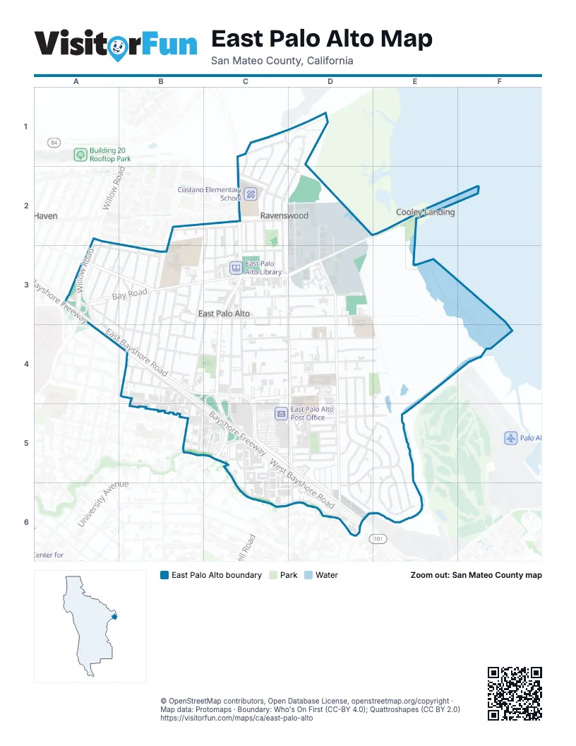
Street index of East Palo Alto
Each street on the sheet and the grid squares it crosses.
- Fordham StreetC1, D1, C2, C3
- Georgetown StreetC1, C2
- Hunter StreetC1, C2
- Rutgers StreetC1, D1
- Stevens AvenueC1, D2
- Tulane AvenueC1
- University AvenueC1, C2, C3, C4, C5
- Xavier StreetC1, C2
- Drew CourtD1
- Illinois StreetD1, C2, D2, C3
- Temple CourtD1
- Alberni StreetA2, A3, B3
- Saratoga AvenueA2, A3
- Westminster AvenueA2, A3
- Clarence CourtB2
- Gertrude CourtB2
- Kavanaugh DriveB2, C2
- Kirkwood CourtB2
- Adams DriveC2
- Annapolis StreetC2, C3
- Baylor StreetC2, C3
- Emmett WayC2, C3
- Farrington WayC2, C3
- Gloria WayC2, C3
- Gonzaga StreetC2, D2, C3
- Hazelwood WayC2, B3, C3
- Notre Dame AvenueC2
- O'Brien DriveC2
- Purdue AvenueC2
- Bay RoadD2, E2, A3, B3, C3, D3
- Demeter StreetD2, D3
- Pulgas AvenueD2, D3, D4, D5, D6
- Tara StreetD2, D3
- Bayshore FreewayA3, A4, B4, C5, D5, D6
- Bradley WayA3
- Calvary Temple Church Parking LotA3
- East Bayshore RoadA3, A4, B4, C4, C5, D5, D6
- Holland StreetA3, B4
- Jervis AvenueA3, B3
- Laurel AvenueA3, B3, A4
- Newbridge StreetA3, B3
- Willow RoadA3
- Addison AvenueB3, B4
- Dumbarton AvenueB3, B4
- Glen WayB3, B4
- Grace AvenueB3, C3
- Lilac LaneB3
- Lincoln StreetB3, B4
- Mello StreetB3
- Menalto AvenueB3, B4
- Oakdale AvenueB3
- Oakwood DriveB3, B4
- Palo Verde AvenueB3
- Poplar AvenueB3, B4
- Ralmar AvenueB3, B4
- Runnymede StreetB3, C3, D3
- Weeks StreetB3, C3, D3
- Avelar StreetC3, C4
- Blue Jay CourtC3
- Capitol AvenueC3, C4, C5
- Carole CourtC3
- Cooley AvenueC3, C4, C5, C6
- Euclid AvenueC3, B4, B5
- Jamie LaneC3
- Michigan AvenueC3
- Paul Robeson CourtC3
- Robin CourtC3
- Sacramento StreetC3
- Tuscany CourtC3, C4
- Ursula WayC3
- Vines CourtC3
- Aspen PlaceD3
- Buchanan CourtD3
- Cedar PlaceD3
- Holly PlaceD3
- Mandela CourtD3, D4
- Maple LaneD3
- Maple PlaceD3
- Montage CircleD3
- Runnymede CourtD3
- Ruth CourtD3
- Veronica CourtD3, D4
- Bell StreetB4, C4, D4
- Donohoe StreetB4, C4, D4, C5
- East O'Keefe StreetB4, B5
- Garden StreetB4, D4, E4
- Green StreetB4, C4, D4
- West Bayshore RoadB4, B5, C5, D5, D6
- Bell CourtC4
- Camphor WayC4
- Henry CourtC4
- Salas CourtC4
- Schembri LaneC4, D4
- Tea CourtC4, D4
- Almond CourtD4
- Azalia DriveD4, D5, E5
- Beech StreetD4, E4
- Brentwood CourtD4
- Clarke CourtD4
- Connolly WayD4
- Cypress StreetD4, E4
- Dines CourtD4
- Larkspur DriveD4, D5, E5
- Lita LaneD4
- Myrtle CourtD4
- Myrtle PlaceD4
- Myrtle StreetD4
- Sage StreetD4
- Shorebreeze CourtD4
- Sparrow CourtD4
- Terra Villa StreetD4
- Vance LaneD4
- Wisteria DriveD4, D5, E5, E6
- Daisy LaneE4, E5
- Manhattan AvenueB5
- O'Connor StreetB5, D5, E5
- Woodland AvenueB5, C5, C6, D6
- Circle DriveC5
- Mission DriveC5, D5, C6, D6
- Newell CourtC5
- Newell RoadC5, C6
- Scofield AvenueC5
- Woodland Apartments private roadC5
- Abelia WayD5, D6
- Baines StreetD5
- Camellia CourtD5, D6
- Camellia DriveD5, E5, D6
- Clarke AvenueD5, D6
- Gaillardia WayD5
- Gardenia CourtD5
- Gardenia WayD5, E5
- Gates StreetD5
- McNair StreetD5
- Mouton CircleD5
- Oakes StreetD5
- Tate StreetD5
- Tinsley StreetD5
- Verbena DriveD5, D6
- Wilks StreetD5
- Daphne CourtE5
- Daphne WayE5, E6
- Hibiscus CourtE5
- Jasmine WayE5, E6
- Lotus WayE5
- Aster WayE6
Places on the map
- Asemblea Apostolica Del Fé en Cristo Jesus
- AutoZone
- Bayshore Christian Ministry Field
- Bell Street Park
- Calvary Temple
- Cardenas
- Cesar Chavez Ravenswood Middle School
- Chùa Giác Minh
- Church of Christ
- Collective Roots Community Garden
- Cooley Landing Park
- Costano Elementary School
- East Palo Alto Charter School
- East Palo Alto City Hall
- East Palo Alto Library
- East Palo Alto Phoenix Academy
- East Palo Alto Police Department
- East Palo Alto Post Office
- East Palo Alto Seventh Day Adventist Church
- East Side Preparatory
- Edison Brentwood Academy
- EPACENTER
- Extra Space Storage
- Faith Baptist Church
- Four Seasons Silicon Valley
- Garden Supermarket
- Home Depot Garden Center
- Hope Horizon East Palo Alto
- IKEA
- Jack Farrell Park
- Joel Davis Park
- Jones Mortuary
- La Estrellita Market & Deli
- Martin Luther King Park
- Mount Olive Missionary Baptist Church
- Open Bible Baptist Church
- Pal Market
- Public Storage
- Ravenswood 101
- University Circle
Next to East Palo Alto
- Belle Haven
© OpenStreetMap contributors, Open Database License, openstreetmap.org/copyright · Map data: Protomaps · Boundary: Who's On First (CC-BY 4.0); Quattroshapes (CC BY 2.0)















