

California map
Eureka map
About 25,412 people live here (Census Bureau, 2024 estimate). The sheet's index lists 272 streets; Redwood Highway, A Street and Broadway Street cross the most grid squares. Things to do inside the boundary: Blue Ox Millworks & Historic Park, California Welcome Center Eureka and Dick Taylor Craft Chocolate.
Open the map (PDF, US Letter)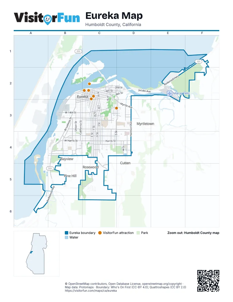
Street index of Eureka
Each street on the sheet and the grid squares it crosses.
- Indianola CutoffF1
- Indianola RoadF1
- Walker Point RoadF1, F2
- 2nd StreetB2, C2, D2
- 3rd StreetB2, C2, D2
- 4th StreetB2, C2, D2
- 5th StreetB2, C2
- A StreetB2, B3, C3, B4, C4
- Broadway StreetB2, B3, B4, B5
- California StreetB2, B3, B4
- Commercial StreetB2, B3
- Laura LaneB2, C2
- Marina WayB2, B3
- Summer StreetB2, B3, B4
- Waterfront DriveB2, C2, B3
- West 2nd StreetB2
- West 3rd StreetB2
- West 4th StreetB2
- West 5th StreetB2, B3
- 1st StreetC2, D2
- 6th StreetC2, D2, B3
- 7th StreetC2, D2, B3, C3
- 8th StreetC2, C3
- B StreetC2, C3, C4
- C StreetC2, C3, C4
- D StreetC2, C3, C4, C5
- E StreetC2, C3, C4
- F StreetC2, C3, C4
- Front StreetC2
- G StreetC2, C3, C4
- H StreetC2, C3, C4
- I StreetC2, C3, C4
- J StreetC2, C3, C4
- K StreetC2, C3, C4
- L StreetC2, C3, C4
- M StreetC2, C3, C4
- Myrtle AvenueC2, C3, D3
- N StreetC2, C3, C4
- O StreetC2, C3, C4
- Opera AlleyC2
- P StreetC2, C3, C4
- Q StreetC2, C3, C4
- R StreetC2, C3, C4
- Redwood HighwayC2, D2, E2, F2, B5, A6, B6
- S StreetC2, C3, C4
- Snug AlleyC2
- Startare DriveC2
- T StreetC2, C3, D3, D4
- U StreetC2, D4
- V StreetC2, D4
- West AvenueC2, D2, C3, D3
- Bay StreetD2, D3
- Gallagher LaneD2
- Jacobs AvenueD2, E2
- Searles StreetD2, D3
- Tydd StreetD2
- W StreetD2, D4
- X StreetD2
- Y StreetD2
- Airport RoadE2
- Albee StreetB3, B4
- Buhne StreetB3, C3, D3
- Fairfield StreetB3, B4
- Felt StreetB3
- Garland StreetB3, B4
- Huntoon StreetB3, C3, D3
- Koster StreetB3
- Long StreetB3, C3
- Pine StreetB3, B4
- Progress StreetB3
- Railroad StreetB3
- Short StreetB3
- Spring StreetB3, B4
- Summit StreetB3, B4
- Union StreetB3, B4
- Vine StreetB3
- West 14th StreetB3, C3
- West 15th StreetB3, C3
- West 6th StreetB3
- West 7th StreetB3
- West Buhne StreetB3
- West Cedar StreetB3, C3
- West Church StreetB3, C3
- West Clark StreetB3, C3
- West Del Norte StreetB3, C3
- West Grant StreetB3, C3
- West Hawthorne StreetB3, C3
- West Huntoon StreetB3
- West Long StreetB3
- West Simpson StreetB3, C3
- West Sonoma StreetB3, C3
- West Trinity StreetB3, C3
- West Wabash AvenueB3, C3
- West Washington StreetB3, C3
- West Waterfront DriveB3
- 10th StreetC3
- 11th StreetC3
- 12th StreetC3
- 13th StreetC3, D3
- 14th StreetC3, D3
- 15th StreetC3, D3
- 16th StreetC3, D3
- 17th StreetC3, D3
- 18th StreetC3, D3
- 9th StreetC3
- Cedar StreetC3
- Church StreetC3
- Claire CourtC3
- Clark StreetC3
- County LaneC3
- Cousins StreetC3
- Del Norte StreetC3
- Eastwood DriveC3
- Gates StreetC3
- Grant StreetC3
- Hawthorne StreetC3
- Heather LaneC3
- Hillsdale StreetC3
- Humboldt StreetC3
- Lowell StreetC3, C4
- Nigel LaneC3
- Papke CourtC3, D3
- Randall StreetC3
- Simpson StreetC3
- Sonoma StreetC3
- Trinity StreetC3
- Viewer AlleyC3
- Wabash AvenueC3
- Washington StreetC3
- Watson StreetC3
- William StreetC3, C4
- 23rd StreetD3
- Christensen WayD3
- Dean StreetD3
- Dowler DriveD3
- Drive Ted Loring DriveD3
- East AvenueD3
- Hardy DriveD3
- Harrison AvenueD3, D4
- Hayden LaneD3
- Hill AvenueD3
- Hill StreetD3
- Hillside DriveD3
- Lindale CourtD3
- Lucas StreetD3
- McFarlan StreetD3
- Munson StreetD3
- Renfrew StreetD3
- Roane AvenueD3
- Robin Hood LaneD3
- Sunny AvenueD3
- Walford DriveD3
- Watson DriveD3
- Allpoints LaneA4
- Christie StreetA4
- Hilfiker LaneA4, B4, A5
- Howell StreetA4
- Patrions CourtA4
- Truesdale StreetA4, B4
- Allard AvenueB4
- Amelia StreetB4
- Andrew StreetB4
- Bayshore WayB4
- Boyle DriveB4, C5
- Brennan StreetB4
- Burrill StreetB4
- Busey LaneB4
- Central AvenueB4
- Cleveland StreetB4
- Cottage StreetB4
- Dakota StreetB4
- Dollison StreetB4, C4
- Elizabeth StreetB4
- Fort AvenueB4
- Gibson AvenueB4
- Glen StreetB4
- Gross StreetB4
- Grotto StreetB4, C4
- Harris StreetB4, C4, D4
- Henderson StreetB4, C4, D4
- High StreetB4
- Highland AvenueB4
- Highland PlaceB4
- Highland StreetB4
- Hiler StreetB4
- Hodgson StreetB4, C4, D4
- Iowa StreetB4
- Kilgore StreetB4
- Little Fairfield StreetB4
- Mc Donald StreetB4
- McCullens AvenueB4
- Muncie StreetB4
- Nevada StreetB4
- New StreetB4, C4
- Ocean AvenueB4
- Oregon StreetB4
- Pearl StreetB4
- Prospect AvenueB4
- Randolph StreetB4, C4
- Rudy StreetB4
- Silva AvenueB4
- Soule StreetB4
- South AvenueB4
- Stewart StreetB4
- Sunnyside AvenueB4
- Thomas StreetB4
- Tomlinson StreetB4
- Utah StreetB4
- Vance StreetB4
- Vigo StreetB4
- West Carson StreetB4
- West Creighton StreetB4
- West Dollison StreetB4
- West Everding StreetB4
- West Grotto StreetB4
- West Harris StreetB4
- West Henderson StreetB4
- West New StreetB4
- West Russ StreetB4
- Bryant StreetC4
- Campton RoadC4, C5
- Carson StreetC4, D4
- Cooper LaneC4
- Copper LaneC4
- Duck StreetC4
- Everding StreetC4, D4
- Glatt StreetC4, D4
- Hayes StreetC4, D4
- Hemlock StreetC4, D4
- Ingley StreetC4
- Jay LaneC4
- Linda LaneC4, D4
- Madrone AvenueC4, D4
- Manzanita AvenueC4, D4
- Orchard StreetC4
- Ponderosa CourtC4
- Russ StreetC4, D4
- Vista DriveC4, C5
- Willow StreetC4
- Wood StreetC4, D4
- Bainbridge StreetD4
- Cherry CourtD4
- Chester StreetD4
- Dolbeer StreetD4
- Erie StreetD4
- Prindan LaneD4
- Russell StreetD4
- Sequoia LaneD4
- St. Joseph LaneD4
- Walnut DriveD4
- Wilson StreetD4
- Barview CourtB5
- Fairway DriveB5, C5
- Herrick AvenueB5
- Pound RoadB5
- Sunset RoadB5
- Weiler RoadB5
- Charles PlaceC5
- Dickson DriveC5
- Fern StreetC5
- Frederick DriveC5
- Leslie RoadC5
- Lundbar PlaceC5
- Lundblade DriveC5
- Morgan PlaceC5
- Patricia DriveC5
- Randy RoadC5
- Ridgecrest DriveC5
- Ridgecrest PlaceC5
- Wells WayC5
- Tooby RoadA6
- Canyon DriveC6
Things to do on the Eureka map
Places on the map
- Adel's Restaurant
- Adventure's Edge
- Alder Bay Assisted Living
- Alice Birney Elementary School
- Antich Automotive
- Applebee's
- Arkley Center for the Performing Arts
- Auto Repair
- Bay West Supply
- Bayshore Mall
- Bayview Heights
- Burre Center
- Carson Mansion
- Cooper Gulch Park
- Daby Island
- Elk River Wildlife Sanctuary
- Eureka High School
- Eureka Marsh
- Eureka Municipal Golf Course
- Eureka Public Marina
- Fay Slough Wildlife Area
- General Hospital Campus
- Halvorsen Park
- Humboldt County Correctional Facility
- Humboldt County Law Library
- Murray Field
- Myrtle Grove Memorial Cemetery
- Oceanview Cemetery
- Redwood Forest - Backyards
- Sempervirens Psychiatric Health Facility
- Sequoia Park
- Sequoia Park Zoo
- Shoreline RV Park
- Sunset Memorial Park
- Table Bluff Wiyot Reservation / giloulh
- Tuluwat Island / Dulawo't
- Umpqua Bank
- Woodley Island
- Woodley Island Marina
Next to Eureka
- Bayview
- Cutten
- Myrtletown
- Pine Hill
- Rosewood
© OpenStreetMap contributors, Open Database License, openstreetmap.org/copyright · Map data: Protomaps · Boundary: Who's On First (CC-BY 4.0); Quattroshapes (CC BY 2.0)















