

California map
Gilroy map
About 60,390 people live here (Census Bureau, 2024 estimate). The sheet's index lists 300 streets; South Valley Freeway, Monterey Road and Santa Teresa Boulevard cross the most grid squares. Also on it: Antonio Del Buono Elementary, Babbs Creek Park Preserve and Brownell Middle School.
Open the map (PDF, US Letter)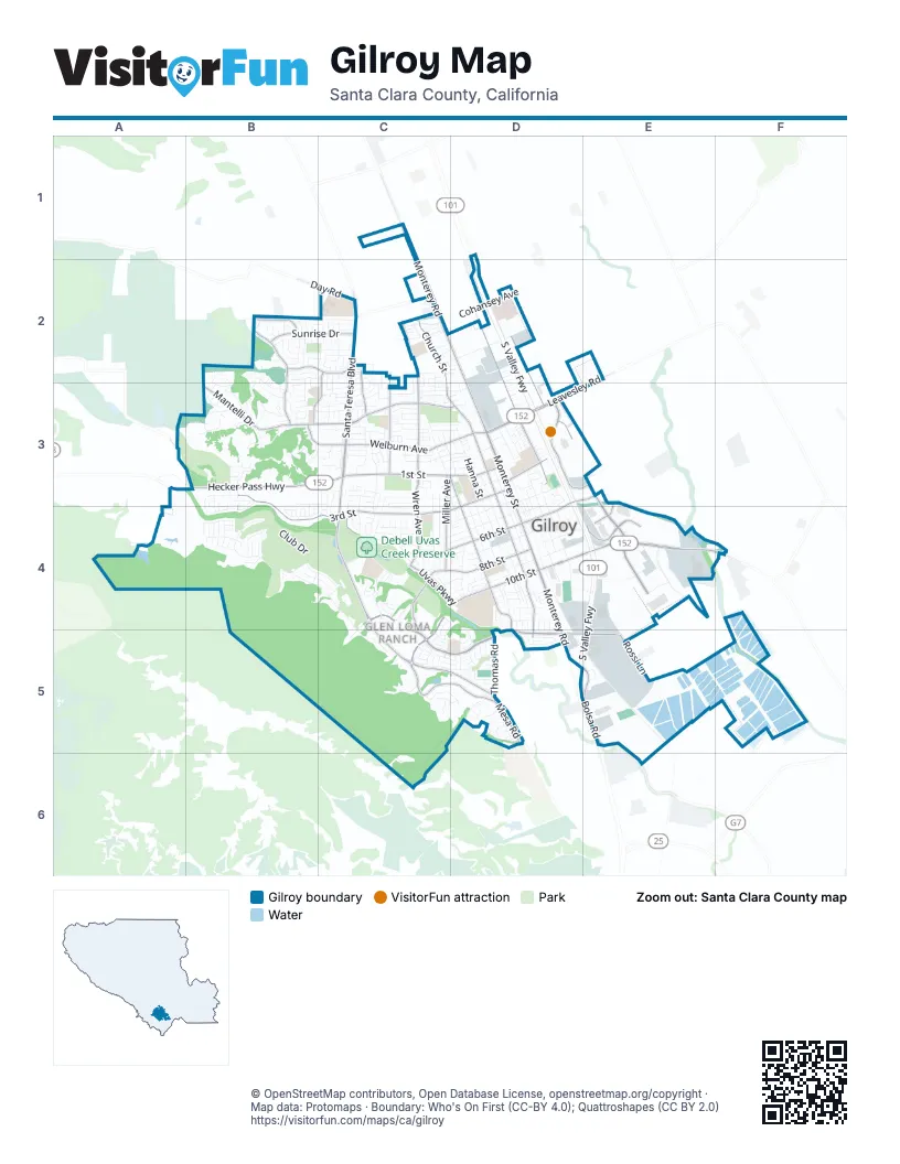
Street index of Gilroy
Each street on the sheet and the grid squares it crosses.
- South Valley FreewayD2, D3, D4, E4, D5, E5
- Monterey RoadC1, C2, D2, D4, D5, E5
- Monterey StreetD2, D3, D4
- Pacheco Pass HighwayE4, F4
- Leavesley RoadD3, E3
- Hecker Pass HighwayB3, C3
- 1st StreetC3, D3
- San Ysidro AvenueD2, D3
- East 10th StreetD4, E4
- Santa Teresa BoulevardC2, C3, C4, C5, D5
- Welburn AvenueB3, C3, D3
- Bolsa RoadE5, E6
- Church StreetC2, C3, D3, D4, D5
- 3rd StreetB3, D3, B4, C4, D4
- Miller AvenueC3, C4, D4, C5, D5
- Mantelli DriveB3, C3, D3
- Camino ArroyoD3, E3, E4
- Wren AvenueC2, C3, C4
- West Luchessa AvenueC4, C5, D5
- West 10th StreetC4, D4, C5
- Murray AvenueD2, D3
- Luchessa AvenueD5, E5
- Princevalle StreetC3, D3, D4
- Arroyo CircleD3, E3
- Rancho Hills DriveB2, B3
- West 6th StreetC4, D4
- Kern AvenueC2, C3
- Renz LaneE4
- Sunrise DriveB2, C2
- West 8th StreetD4
- Longmeadow DriveB2, C2
- Uvas ParkwayC4, D4
- Mesa RoadD5
- Calle del ReyC2, B3, C3
- Rossi LaneE5
- Day RoadC2
- East 6th StreetD3, D4
- IOOF AvenueD3
- Uvas Park DriveC4
- Hirasaki AvenueC2, C3
- Thomas RoadD5
- 6th StreetD3, E3
- Lindsteadt WayE3, E4
- Cielo Vista LaneB2
- Coyote Moon LaneB2
- Burchell RoadA3
- Club DriveB4, C4
- Forest StreetD2, D3, D4
- Hanna StreetD3, D4
- Rosanna StreetD3, D4
- Carmel StreetC3, D3, D4
- Cohansey AvenueC2, D2
- Eagle Ridge DriveB4, C4, C5
- Eigleberry StreetD3, D4
- Cameron BoulevardE4
- Southside DriveE5, F5
- Westwood DriveC3, C4
- Alexander StreetD3, D4
- 4th StreetD3, C4, D4
- Chestnut StreetD3, D4
- Las Animas AvenueD2
- No Name UnoD2
- 5th StreetC4, D4
- Grassland WayB3, B4
- Automall ParkwayD4, D5
- West 9th StreetD4
- Saint Andrew's CircleB4, C4
- Oak Brook WayC5, D5
- Country DriveB3
- 2nd StreetC3, D3
- El Cerrito WayC3, D3
- Dowdy StreetD3, D4
- Old Gilroy StreetD4, E4
- Wagon Wheel CircleD3
- Santa Theresa DriveC3, C4
- Wayland LaneC3
- Merlot DriveC4, C5
- Rosemary DriveB3, C3, B4, C4
- Holloway RoadE4
- Kelton DriveC3
- Orchard DriveD4
- Filice DriveC3, C4
- West 7th StreetD4
- Ronan AvenueC3, D3
- Lewis StreetD3
- Hollyhock LaneB3
- Winged Foot DriveC5, D5
- Grenache WayC4
- Delta DriveC3
- Herbal LoopE5
- Muirfield WayB4
- Santa Barbara DriveC3, C4
- Victoria DriveD4
- Tarragon DriveB3, C3
- East 9th StreetD4, E4
- Valley Oaks DriveB2, B3
- Stonecress StreetB3
- San Miguel StreetC4
- Holsclaw RoadE4, F4
- Swanston LaneD3
- Pitlochry DriveB4, C4
- Broadway StreetC3, D3
- Troon WayB4
- Farrell AvenueC2
- Laurel DriveC3, C4
- Portrush CourtC5
- Sunflower CircleB3
- Babbs Creek DriveD5
- Gourmet AlleyD3, D4
- Tatum AvenueC2
- Tea Tree WayB2, B3
- Columbine CourtB3
- Obata WayE5
- Cobblestone CourtC3, C4
- East 8th StreetD4
- Santa Paula DriveC4
- Syrah DriveC4
- Railroad StreetD3, D4
- Yorktown DriveC4, D4
- Briarberry LaneB2
- Crest Hill WayB2, B3
- Ayer DriveC4
- San Justo RoadD5
- Peregrine DriveB2
- Cypress CourtC3
- Isabella WayC3, C4
- Newton AlleyD3, D4
- Silacci WayE4
- Ortega CircleC3, C4
- Mossrose WayB3
- Mayock RoadE5
- Greenfield DriveD5
- Roundstone DriveB4
- Ousley DriveC3
- Autumn DriveB3
- East 7th StreetD4
- Banyan CourtB2, B3
- Longmeadow CourtB2
- Monte Bello DriveC3
- Loganberry DriveB2, B3
- Eden StreetC3
- Lusitano WayD5
- Martin StreetD3, D4
- Rodeo DriveC2
- Sister Cities CreekC4
- Bay Tree DriveB3, C3
- Walnut LaneD3
- Ramona WayC3
- Sherwood DriveC3, D3
- Charles Lux DriveC5, D5
- Pheasant DriveB2, C2
- Arnold DriveC3, D3
- Cheyenne DriveC2
- Eagle View WayB2
- Sprig WayC2
- Wildflower CourtD5
- Ballybunion DriveC4, C5
- Lavendar WayB3
- Meadow Wood CourtB3
- Gaunt AvenueC3
- Rogers LaneD3, D4
- Quail Walk DriveB2
- Bluebell DriveA3, B3
- Cinnamon WayC3, C4
- Siena DriveC3
- Nightingale DriveC2
- Eschenburg DriveC4, D4
- Yawi PlaceC4
- Travel Park CircleE5
- Bultustrol DriveC5, D5
- Vintner CourtC4
- Strath PlaceB4
- Lopez WayC4, D4, C5
- Rancho RealB3
- Crawford DriveC4
- Venture WayE4
- Fairview DriveD4
- Eagle Hills WayB2
- Pueblo StreetC2
- Geronimo StreetC2
- La Sierra WayC3, D3
- Portmarnock WayB4, C4
- Wentz DriveC4
- Rea StreetD3, D4
- Ponderosa DriveC3, C4
- Lahinch DriveB4, C4
- Lilly AvenueD3
- Padova DriveC3
- Lawrence DriveC3
- Driftwood TerraceC3, C4
- Hyde Park DriveD4, D5
- Cimino StreetC5
- Mesa StreetD4
- Del Mar StreetD4
- Arapaho DriveC2
- Springdale CourtD3
- El Toro WayC3, D3
- Caspian WayD5
- Riverview CreekD5
- Hacienda DriveC4
- Rancho Vista DriveA4
- Acorn WayB3
- Dawn WayD5
- Carignane DriveD5
- El CaminitoC2, C3
- La Paloma WayC3
- Gary StreetC3
- Kentwood CourtC4
- Perrelli StreetC4
- Vlognier WayC5, D5
- Automall DriveD4, E4
- Taos WayC2, C3
- Kipling CircleC3
- Cougar CourtC2
- Fillippelli DriveC3
- Eldorado DriveC3
- Apricot WayB3
- Nicole WayD5
- Calabrese WayC3
- London DriveD4
- Howard AvenueC3
- Saddler DriveC2
- Vista del SurB3
- Alder StreetD5
- Vintner StreetC4, C5
- Plymouth DriveC4, D4
- Valbusa DriveC3
- Wild Iris DriveB3
- Liman AvenueD2, C3
- Monticelli DriveC2, C3
- Cumberland DriveC4, D4
- Zinnia StreetC3
- Muraoka DriveD2, D3
- Olea CourtB2
- Hersman DriveC4
- Sturla WayC2
- Carob CourtB2
- Clark WayC4
- Shire StreetD5
- Williamsburg WayD4
- Partridge DriveB3
- Glenview DriveD4
- Byers StreetC4
- Mirassou LaneC5
- Godani StreetC5
- Haybale StreetB3
- Pappani DriveC3
- Spice LaneE5
- Swaner DriveC3
- Castlewood PlaceC4
- Daffodil PlaceC3
- Chickadee LaneC2
- Berwick AvenueB4
- Lions Creek DriveC3
- Churchill PlaceD4
- Festa Agilio DriveC3
- Ruby WayC5, D5
- Little Barn LaneB3
- Alta StreetD4
- Apple Tree WayB3
- Carla WayC3
- La Primavera WayC2
- Maria WayC3
- Monte Vista WayD4
- Cabrillo CourtC3
- Bobcat CourtC2
- Juniper DriveC3
- Solana DriveC2, C3
- Cruden Bay WayB4
- Sarfina WayD3
- Pierce StreetD3
- Buena Vista AvenueD1, C2
- Gettysburg WayD4
- Mustard Seed WayB3, B4
- Banyan StreetB3
- Casablanca CircleC3
- Kishimura DriveD2
- Blue Parrot CourtC3
- San Ysidro ParkD3
- Sorrento DriveC3
- La Alondra WayC3
- Aspen WayC3
- Eagle Nest WayB2
- Larkspur LaneB3
- Chesbro WayC3
- Harrier PlaceC2
- Hurka WayC4
- Petersen DriveC3
- Hoxett StreetC4
- Olympic CourtC5
- West Las Animas AvenueC2, D2
- Bogiala WayC4, C5
- Fine DriveB3
- Culp DriveC3
- Dornoch CourtC4
- Lemon Grass LaneB3, B4
- Amanda AvenueC3
- Adobe PlazaD4
- Casa Del Sol StreetD4
- Hoya LaneB2, B3
Places on the map
- Antonio Del Buono Elementary
- Babbs Creek Park Preserve
- Brownell Middle School
- Canyon Creek
- Cesar E. Chavez Library
- Christmas Hill
- Christmas Hill Park
- Christopher High School
- Costco
- Coyote Lake
- Debell Uvas Creek Preserve
- Dry Creek Village
- Eagle Ridge Golf Club
- Fed Ex Center
- FedEx Ship Center
- Garlic Farm RV Park
- Gavilan Hills Memorial Park
- Gilroy Automall
- Gilroy City Hall
- Gilroy Crossing
- Gilroy Gardens
- Gilroy Garlic USA RV Park
- Gilroy Golf Course
- Gilroy High School
- Gilroy Medical Park
- Gilroy Premium Outlets
- Glen Loma Ranch
- Glen View School
- Las Animas Veterans Park
- Lowe's
- Malvasia II
- McCarthy Business Park
- Pacheco Pass Center
- Recology South Valley
- Rocky Knoll
- Saint Louise Regional Hospital
- Saint Mary Church and School
- Southpoint Business Park
© OpenStreetMap contributors, Open Database License, openstreetmap.org/copyright · Map data: Protomaps · Boundary: Who's On First (CC-BY 4.0); Quattroshapes (CC BY 2.0)