

California map
Imperial Beach map
About 25,568 people live here (Census Bureau, 2024 estimate). The sheet's index lists 102 streets; Palm Avenue, 8th Street and Grove Avenue cross the most grid squares. Also on it: NOLF Imperial Beach Main Base, Ream Field and Naval Base Coronado - Imperial Beach.
Open the map (PDF, US Letter)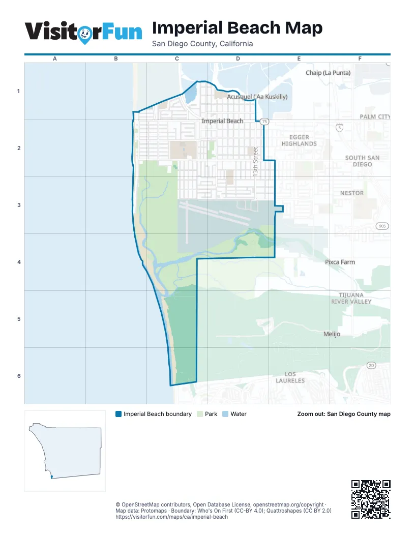
Street index of Imperial Beach
Each street on the sheet and the grid squares it crosses.
- Calla AvenueB1, C1, D1
- Carnation AvenueB1, C1
- Citrus AvenueB1, C1
- Seacoast DriveB1, B2, B3
- 3rd StreetC1, C2
- 4th StreetC1, C2
- 5th StreetC1, C2, C3
- 7th StreetC1, C2
- Alabama StreetC1, C2
- Basswood AvenueC1, D1
- Bayside WayC1
- Bonito AvenueC1
- Boulevard AvenueC1, D1
- Cherry AvenueC1, D1
- Corvina StreetC1, C2
- Cypress AvenueC1, D1
- Delaware StreetC1, C2, C3
- Finch LaneC1
- Heron LaneC1
- Hummingbird LaneC1
- Lark WayC1
- Palm AvenueC1, D1, B2, C2, D2
- Pelican LaneC1
- Rainbow DriveC1, C2
- Sanderling LaneC1
- Sandpiper WayC1
- Shorebird WayC1
- Silver StrandC1
- Silver Strand BoulevardC1, C2
- Surfbird LaneC1
- Turnstone LaneC1
- 10th StreetD1, D2, D3
- 11th StreetD1, D2, D3
- 12th StreetD1, D2, D3
- 13th StreetD1, D2, D3
- 8th StreetD1, C2, D2, D3
- 9th StreetD1, D2, D3
- Emory StreetD1, D2, D3
- Florence AlleyD1, D2, D3
- Florence StreetD1, D2, D3
- Florida StreetD1, D2, D3
- Admiratty AvenueB2
- Beach AvenueB2
- Dahlia AvenueB2, C2
- Daisy AvenueB2, C2
- Date AvenueB2, C2
- Donax AvenueB2, C2, D2
- Ebony AvenueB2, C2, D2
- Elder AvenueB2, C2, D2
- Elkwood AvenueB2, C2
- Elm AvenueB2, C2, D2
- Evergreen AvenueB2, C2
- Imperial Beach BoulevardB2, C2, D2
- Ocean BoulevardB2
- 2nd StreetC2
- A StreetC2
- B StreetC2
- C StreetC2
- California StreetC2, C3
- Carolina StreetC2
- Caspian WayC2
- Connecticut StreetC2, C3
- East LaneC2, C3
- Encina AvenueC2, D2
- Fern AvenueC2, D2
- Grove AvenueC2, C3, D3, E3
- Louden LaneC2, C3
- Sea Village DriveC2
- Spruce StreetC2
- Thorn StreetC2
- 14th StreetD2, D3
- Coronado AvenueD2, E2
- Downing StreetD2, D3
- Essex StreetD2, D3
- Georgia StreetD2, D3
- Ivy LaneD2
- 15th StreetE2, E3
- Granger StreetE2, E3
- Cortez AvenueB3
- Descanso AvenueB3
- Hemlock AvenueC3, D3, E3
- Hickory CourtC3, D3
- Holly AvenueC3, D3, E3
- Iris AvenueC3, D3, E3
- Oneonta AvenueC3, D3
- Tower RoadC3, D3, C4
- Adelfa CourtD3
- Arriba AvenidaD3
- Beverly AvenueD3
- Boundary RoadD3, E3, C4, D4
- Butler StreetD3, E3
- Gatlin StreetD3, E3
- Lexington StreetD3
- Saratoga StreetD3
- Sea Park DriveD3
- Sea View DriveD3
- Cochabamba StreetE3
- Ionian StreetE3
- Jason StreetE3
- Satellite BoulevardE3
- Yorktown StreetE3
- Monument RoadC6
Places on the map
- Bayside Steam Academy
- Beach LZ
- BodyWorks Collision, Inc
- Breakwater
- Central Elementary School
- Chase
- City of Imperial Beach Public Works
- CVS Pharmacy
- Dollar Tree
- Goodwill
- Grocery Outlet
- Hampton Inn & Suites Imperial Beach San Diego
- Imperial Beach Branch Library
- Imperial Beach Charter School
- Imperial Beach City Hall
- Imperial Beach Civic Center
- Imperial Beach Commissary
- Imperial Beach Dog Park
- Imperial Beach Fire-Rescue Department
- Imperial Beach Navy Exchange
- Imperial Beach Pier Plaza
- Imperial Beach Plaza
- Imperial Beach Post Office
- Imperial Beach Promenade
- International Friendship Park
- Mar Vista High School Library
- Mar Vista Senior High School
- Motorpool
- Naval Base Coronado - Imperial Beach
- Naval Outlying Landing Field Imperial Beach
- NOLF Imperial Beach Main Base
- Pond 10A
- Ream Field
- Tijuana Slough National Wildlife Refuge
- Veterans Park
Next to Imperial Beach
- Acusquel ('Aa Kuskilly)
- Chaip (La Punta)
- Egger Highlands
- Los Laureles
- Melijo
- Misión del Sol
- Nestor
- Palm City
- Pixca Farm
- Playas de Tijuana Secc Coronado
- Playas de Tijuana Secc Terrazas
- Puesta del Sol
- South San Diego
- Tijuana River Valley
- Vista del Pacifico
© OpenStreetMap contributors, Open Database License, openstreetmap.org/copyright · Map data: Protomaps · Boundary: Who's On First (CC-BY 4.0); Quattroshapes (CC BY 2.0)















