

California map
Laguna Beach map
About 22,564 people live here (Census Bureau, 2024 estimate). The sheet's index lists 300 streets; Pacific Coast Highway, Laguna Canyon Road and Skyline Drive cross the most grid squares. Things to do inside the boundary: Laguna Beach Visitors Center and Museum of Make Believe.
Open the map (PDF, US Letter)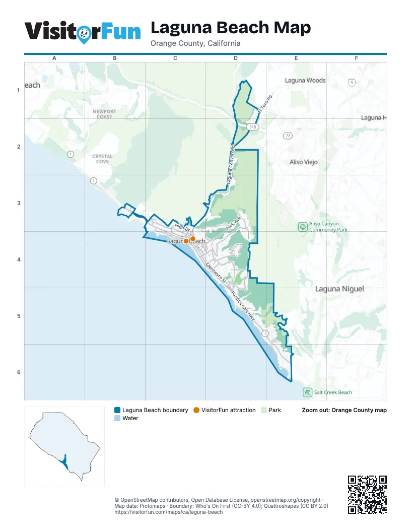
Street index of Laguna Beach
Each street on the sheet and the grid squares it crosses.
- San Joaquin Hills Transportation CorridorD2
- Pacific Coast HighwayB3, C3, C4, D4, D5, E5, E6
- Laguna Canyon RoadD1, D2, C3, D3, C4
- El Toro RoadD1, D2
- Cliff DriveC3, C4
- Broadway StreetC4
- Forest AvenueC4
- Irvine Cove WayB3
- Park AvenueD3, C4, D4
- Glenneyre StreetC4, D4, D5
- Alta Laguna BoulevardD3, D4
- Thalia StreetC4, D4
- Calliope StreetD4
- Laguna AvenueC4
- Temple Hills DriveD3, D4
- Bluebird Canyon DriveD4
- Skyline DriveC3, D3, C4, D4
- High DriveC3, C4
- Morningside DriveD4
- Catalina StreetC4, D4
- Nyes PlaceD4, D5
- Hillcrest DriveC3
- Summit DriveD4
- Alta Vista WayD4, D5
- Balboa AvenueD4, D5
- Cypress DriveC4
- Del Mar AvenueD4
- Monterey DriveC3, C4
- Cress StreetC4, D4
- Temple TerraceD4
- La Mirada StreetD4
- Saint Anns DriveC4, D4
- Wilson StreetC4, D4
- Aster StreetC3, C4
- Ocean AvenueC4
- Wesley DriveD5
- Ledroit StreetC3
- Legion StreetC4
- Solana WayD4, D5
- El Camino del MarC4
- Sunset Ridge DriveC3
- 3rd StreetC4
- Linden StreetC3, C4
- Mermaid StreetC4
- El BosqueC4
- Acacia DriveC4
- Blue Bird Canyon DriveD4
- Rancho Laguna RoadD4
- Highland WayD5
- Beach StreetC4
- 2nd StreetC4
- Short StreetC4
- Eleanor LaneC3
- Rosa Bonheur DriveC4
- North Beach StreetC4
- Victoria PlaceD5
- Vista del SolE6
- Diamond StreetD4
- Brooks StreetC4, D4, D5
- Mountain View DriveD3, D4
- Monterey StreetD5, E5
- Cedar WayC4
- Virginia WayE5, E6
- South la Senda DriveE6
- CozumelD2
- Mystic WayC4, D4
- Oak StreetC4, D4
- Rim Rock Canyon RoadD4
- Canyon Acres DriveC3, D3
- Lagunita DriveD5
- Crestview DriveD4
- Canyon View DriveD4
- Cerritos DriveD4
- San Nicholas CourtD1, D2
- CatalinaD4
- Sunset AvenueE5, E6
- Allview TerraceC3
- Summit WayD4
- Capistrano AvenueD4
- Eagle Rock WayD5, E5
- Zell DriveD3, D4
- Gaviota DriveC4, D4
- Holly DriveD5
- Anita StreetC4, D4
- Mar Vista AvenueE5
- K StreetD5
- Pearl StreetD4
- Crescent Bay DriveC3
- Tahiti AvenueD3
- Riviera DriveB3
- Coast View DriveD4
- Jasmine StreetC3, C4
- Dunning DriveD4
- Terrace WayD4
- Myrtle StreetC3, C4
- 3rd AvenueE5
- Blue LagoonD5
- Wendt TerraceD4
- Bern DriveD3
- Agate StreetD4
- North Vista de CatalinaE6
- Sun Valley DriveD2
- Castle Rock RoadD3
- Ocean Vista DriveD5
- Ocean WayD4
- Victoria DriveD5
- Carmelita StreetD4
- San Tropez CourtD2
- Katella StreetD4
- Mountain RoadD4
- Smithcliffs RoadC3
- Seaview StreetC4, D4, E5
- Ramona AvenueC4
- Vista LaneC3, C4
- Caribbean WayD3
- Regatta RoadD4
- Anacapa WayC3, D3, C4
- Center StreetD4
- Goff StreetC4
- Canyon Hill DriveD1
- CortezD4
- West StreetD5, E5
- North la Senda DriveE6
- Chillon WayD3, D4
- Dartmoor StreetC3
- Monaco DriveB3
- Alta Loma DriveD5
- Aliso Canyon RoadE5
- Top of the World DriveD4
- Lewellyn DriveD3
- Van Dyke DriveD4
- Baja StreetD4
- Bolsana DriveD4, D5
- Holly StreetC3, C4
- North Stonington RoadE6
- Miramar StreetD4
- Marilyn DriveD5
- Paseo del SurE5
- Laguna Canyon Frontage RoadC3
- Gainsborough DriveD4
- Locust StreetC3, C4
- Poplar StreetC3, C4
- Buena Vista WayD4
- Pedro StreetD5
- Scenic DriveE5
- Santa Cruz StreetD4
- San Remo DriveD4
- South PortolaE6
- Virginia Park DriveC4
- Chateau WayD3, D4
- Loma TerraceC4
- Tyrol DriveD3
- Rembrandt DriveD4
- Country Club RoadD5
- Coral DriveD3
- Ceanothus DriveD5
- Ruby StreetD4
- Irvine Cove CrestB3
- M StreetD5
- Cleo StreetC4
- Oriole DriveD4
- Lombardy LaneD4
- Hillview DriveD3
- McKnight DriveC3
- Driftwood DriveD5
- Starlit DriveD4
- La Vista DriveC4, D4
- Chiquita StreetC3, C4
- Donna DriveD4
- Mystic ViewC3, C4
- North PortolaE6
- Santa Rosa CourtD1, D2
- Bonn DriveD3
- Circle WayC3
- 2nd AvenueE5
- Hawthorne RoadC3, C4
- Crestview PlaceD4
- La Brea StreetC3, C4
- Flora StreetD4
- Pacific AvenueD3, D4
- 8th AvenueE5, E6
- La Costa CourtD1
- Lower Cliff DriveC4
- H StreetD5
- Noria StreetD4
- Santa Ana StreetD4
- Louise StreetC3
- Seacliff DriveD5, E5
- Tia Juana StreetD4
- Fairview StreetC3, C4
- Wave StreetC3, C4
- Oro StreetD4
- Wykoff WayD4
- Saint Ann's DriveC4
- Dolphin WayC3, C4
- Cresta WayD3
- Arroyo DriveD3
- Encinitas CourtD1
- Coronado DriveC3, C4
- Jewel AvenueE5
- Bay DriveE6
- Wildwood RoadE5
- Bluff DriveD5
- Carmel CourtD1
- Hilledge DriveC4
- Moss StreetD4
- Stan Oak DriveD3
- D StreetD5
- F StreetD5
- Weymouth PlaceC3
- Viejo StreetC3
- South EncinoE6
- Irvine Cove DriveB3
- Aswut TrailD4
- Dyer PlaceD4
- Florence AvenueE5
- 5th AvenueE5
- Stairstep TrailD2
- 7th AvenueE5
- Quivera StreetD4
- Acapulco StreetD4
- Los RoblesC4
- Pinecrest DriveC3
- 9th AvenueE5, E6
- Catalina AvenueD5, E5
- Alisos AvenueD4
- North Vista de la LunaE6
- Barracuda WayD4
- South Stonington RoadE6
- Sleepy Hollow LaneC4
- Circle DriveE5, E6
- Nestall RoadD3
- Marine DriveC4
- Woodland DriveC3
- Fairview RoadE5
- Blumont StreetC4
- Flamingo RoadD4
- Montage WayD5
- Dunnegan DriveC3
- 4th AvenueE5
- Artisan DriveD2
- Santa Rosa DriveE5
- Bayview PlaceD4
- Hidden Valley Canyon RoadD3
- MarlinD4
- Sunset TerraceD5
- Griffith WayD4
- Meadowlark DriveD4
- Thurston DriveD4
- Harold DriveC3
- Shady LaneD4
- Madison PlaceD4
- Rounsevel TerraceD5
- Altamar DriveB3
- Bounty WayD3
- Dumond DriveD5
- Terry RoadD5
- Queda WayD4, D5
- Aliso CircleD5
- Eastline DriveE6
- Manzanita DrivewC4
- North CallecitaE6
- South Vista de CatalinaE6
- Broadway PlaceC4
- Magnolia DriveC4
- Vista de San ClementeE6
- Kendall DriveD4
- Treetop LaneD4
- Table Rock DriveD5
- Cuprien WayD4
- G StreetD5
- Cajon StreetC3
- Nido WayD4
- Atelier LaneD5
- South TerraceD5
- Beverly StreetC3
- Forest LaneC4
- Dorn CourtD3
- Pala WayD4
- Graceland DriveC4, D4
- Pacfic VistaD4
- Kilo WayD4
- North EncinoE6
- Shamrock RoadB3
- San Joaquin StreetC3
- South Vista de la LunaE6
- Juanita WayD4
- Upper Rim Rock RoadD4
- 10th AvenueE6
- Ridge DriveD3
- Heather PlaceC3
- Rockledge RoadD4, D5
- Egan RoadE5
- Bernard CourtD4
- South CallecitaE6
- Anns LaneD4
- Monte Carlo DriveB3
- Lookout DriveC3
- Meadowlark LaneD4
- Loretta DriveD4
Things to do on the Laguna Beach map
Places on the map
- Aliso Beach
- Aliso Beach County Park
- Aliso Creek
- Aliso Peak
- Alta Laguna Park
- American Legion - Laguna Beach Post 222
- Arch Beach Heights Park
- Art Hotel
- Assistance League of Laguna Beach Thrift Shop
- Barbara's Lake
- Big Bend Staging Area
- Biryani Hunter
- Bluebird Park
- Boat Canyon Park
- Boys & Girls Club
- Boys & Girls Club - Bluebird Branch
- Broadway Liquor-Mart
- Bushard's Pharmacy
- Canyon Body & Paint
- Capri Laguna on the Beach
- Carmelita’s
- Casa Loma Beach Hotel
- Coast Royale Beach
- Cresent Bay Beach
- Heisler Park
- James Dilley Greenbelt Preserve
- Laguna Beach City Hall
- Laguna Beach High School
- Laguna Beach Post Office Playa Station
- Laguna Playhouse
- Main Beach
- Main Beach Park
- Mission Hospital Laguna Beach
- Temple Hill
- The Ranch at Laguna BeachGolf Course
- The UPS Store
- Thousand Steps Beach
- Treasure Island Park
- Urth Cafe
- Victoria Beach
Next to Laguna Beach
- Acacia Knolls
- Aliso Viejo map
- Crystal Cove
- Laguna Hills map
- Laguna Niguel map
- Laguna Woods map
- Newport Coast
© OpenStreetMap contributors, Open Database License, openstreetmap.org/copyright · Map data: Protomaps · Boundary: Who's On First (CC-BY 4.0); Quattroshapes (CC BY 2.0)















