

California map
Orange County map
About 3,170,435 people live here (Census Bureau, 2024 estimate). The sheet's index lists 26 streets; San Diego Freeway, Santa Ana Freeway and Riverside Freeway cross the most grid squares. Things to do inside the boundary: Anaheim, Anaheim Topgolf Swing Suite and Capt. Dave's Dolphin & Whale Watching Safari.
Open the map (PDF, US Letter)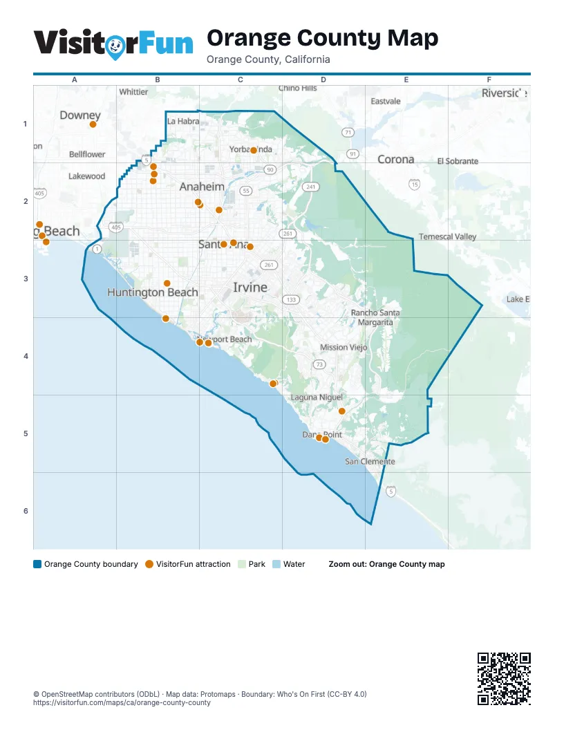
Maps inside Orange County
3 maps inside, from the street map of Orange County down.
Street index of Orange County
Each street on the sheet and the grid squares it crosses.
- Santa Ana FreewayB1, B2, C2, C3, D3, D4
- East Imperial HighwayC1, C2
- Orange FreewayC1, C2
- 91 Express LanesD1, C2, D2
- HOV 3+ LaneD1
- Riverside FreewayD1, B2, C2, D2
- Garden Grove FreewayA2, B2, C2
- San Diego FreewayA2, B2, B3, C3, D3, D4, D5, E5, E6
- San Gabriel River FreewayA2
- Artesia FreewayB2
- Artesia TollwayB2
- Costa Mesa FreewayC2, C3
- I 5 NorthC2
- I 5 SouthC2
- I5 North CA 57 NorthC2
- Imperial HighwayC2
- South Imperial HighwayC2
- Eastern Transportation CorridorD2, C3, D3
- Foothill Transportation CorridorD2, D3, E3, E4
- CA 55 South HOVC3
- Corona Del Mar FreewayC3
- I 405 N HOVC3
- Jamboree RoadC3
- San Joaquin Hills Transportation CorridorC3, C4, D4
- Laguna FreewayD3
- Los Patrones ParkwayE4
Things to do on the Orange County map
- Anaheim
- Anaheim Topgolf Swing Suite
- Capt. Dave's Dolphin & Whale Watching Safari
- Catalina Flyer
- Dana Wharf Sportfishing
- Discount Tickets & Tours
- Disneyland Park
- Huntington Beach
- Intrepid Escape Rooms
- Knott's Berry Farm
- Laguna Beach Visitors Center
- Lyon Air Museum
- Mission San Juan Capistrano
- Museum of Make Believe
- Newport Beach
- Newport Landing Whale Watching
- Pirates Dinner Adventure
- Richard Nixon Presidential Library and Museum
- Santa Ana
- Santa Ynez Valley
- Visit Buena Park
Places on the map
- 93 acre park expansion
- Acacia Knolls
- Aliso and Wood Canyons Wilderness Park
- Aliso Canyon Community Park
- Aliso Viejo
- Alta Vista Country Club
- Altair
- Anaheim
- Anaheim Coves Park
- Anaheim Hills Golf Course
- Arroyo Trabuco Golf Club
- Baker Ranch
- Balboa Beach
- Balboa Island
- Balboa Peninsula
- Beacon Park
- Beverly Gardens
- Big Canyon Country Club
- Black Gold Golf Club
- Blackstone
- Bolsa Chica Ecological Reserve
- Bolsa Chica State Beach
- Bommer Canyon - Open Space
- Bosque Canyon
- Brea
- Brea Dam Park
- Broadcom
- Broadmoor
- Buck Gully Reserve
- Buena Park
- Cadence Park
- Cameo Cliffs
- Canyon Crest
- Canyon RV Park
- Capistrano Beach
- Casta del Sol
- Chino Hills State Park
- Clearbrook Park
- College Park
- Columbus Square Community
Next to Orange County
- Bellflower
- Chino Hills
- Corona
- Downey
- Eastvale
- El Sobrante
- La Mirada
- Lake Elsinore
- Lakewood
- Long Beach map
- Norco
- Norwalk
- Pico Rivera
- Riverside map
- Santa Fe Springs
- Signal Hill
- South Gate
- Temescal Valley
- Whittier
© OpenStreetMap contributors (ODbL) · Map data: Protomaps · Boundary: Who's On First (CC-BY 4.0)