

California map
Larkspur map
About 12,807 people live here (Census Bureau, 2024 estimate). The sheet's index lists 206 streets; Magnolia Avenue, Sir Francis Drake Boulevard and Walnut Avenue cross the most grid squares. Also on it: Corte Madera Creek, Greenbrae Boardwalk and Blithedale Summit Open Space Preserve.
Open the map (PDF, US Letter)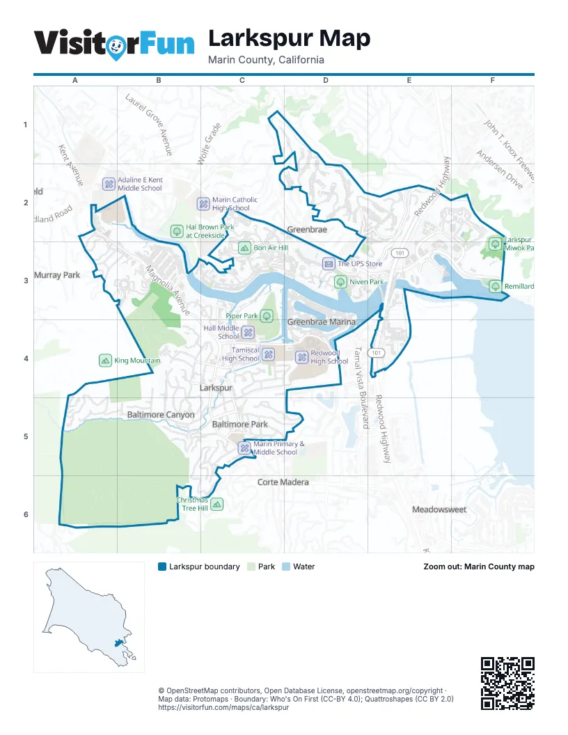
Street index of Larkspur
Each street on the sheet and the grid squares it crosses.
- Corte AmadoC1
- North Almenar DriveC1, D1, C2
- Altura WayD1, D2
- Cielo DriveD1, D2
- Paseo WayD1, D2
- College AvenueA2
- College CourtA2
- Estelle AvenueA2, A3
- Hillcrest AvenueA2, A3
- Magnolia AvenueA2, B3, C4, C5
- Murray LaneA2
- Bon Air RoadC2, B3
- Corte del NorteC2
- Corte EncantoC2, C3
- Corte LenosaC2
- Corte SolanoC2
- El Portal DriveC2, C3
- Sir Francis Drake BoulevardC2, D2, D3, E3
- Spyglass HillC2, C3
- Via HidalgoC2, C3
- Bretano WayD2, E2, E3
- Corte AlejoD2
- Corte BaristoD2
- Corte GracitasD2
- Corte LodatoD2
- Corte LoyolaD2
- Corte PrecitaD2
- Corte RamonD2
- Eliseo DriveD2, E2, D3
- La Cuesta DriveD2
- Via BarrancaD2, E2
- Via CheparroD2
- Via la PazD2
- Via LeridaD2
- Via NavarroD2, E2
- Bret Harte RoadE2
- Corte FedoraE2
- Corte PlacidaE2
- Corte TolucaE2
- Larkspur Landing CircleE2, E3, F3
- Old Quarry Road NorthE2, F2
- Old Quarry Road SouthE2, F2
- Redwood HighwayE2, E3, E4
- Tiburon BoulevardE2
- Via HermosaE2
- Via la CumbreE2, D3, E3
- Lincoln Village CircleF2, F3
- Arbor StreetA3
- Bayo Vista AvenueA3
- Briar RoadA3
- Frances AvenueA3, B3
- Murray AvenueA3, B3
- Cornell AvenueB3
- Creekside DriveB3, C3, C4
- Crystal Creek DriveB3
- Dartmouth DriveB3
- Edgewater PlaceB3
- Escalle LaneB3
- Harvard DriveB3
- Ridgecrest RoadB3
- Skylark DriveB3
- South Eliseo DriveB3, C3, D3
- Stanford CourtB3
- Tulane DriveB3
- Yale AvenueB3
- Bayview RoadC3
- Corte OrientalC3
- Corte OrtegaC3
- Corte RealC3
- Creek View CircleC3
- Cross Creek PlaceC3, C4
- Larkspur Plaza DriveC3, C4
- Lower Via CasitasC3, D3
- Sandy Creek WayC3
- Tamalpais RoadC3
- Upper Via CasitasC3, D3
- Via BelardoC3
- Via CasitasC3
- Via HolonC3
- Barry WayD3
- Corte del BayoD3
- Corte del CoronadoD3, D4
- Del MonteD3
- Drakes Landing RoadD3
- Drakes View CircleD3
- Elizabeth CircleD3
- Gregory PlaceD3
- Gretchen PlaceD3
- Laderman LaneD3
- Mark PlaceD3
- Parkside WayD3, E3
- Riviera CircleD3, D4
- Scott PlaceD3
- Greenbrae BoardwalkE3
- Marin ParkE3
- Marin Park SouthE3, E4
- Marin RV Park NorthE3
- Sir Francis Drake Boulevard EastE3, F3
- Victoria WayE3
- Drakes Cove CourtF3
- Drakes Cove RoadF3
- Drakes Cove WayF3
- Drakes WayF3
- Oak RoadA4, A5
- Redwood AvenueA4, A5
- Wilson AvenueA4, A5
- Ajax StreetB4, C4
- Bond StreetB4
- Cedar AvenueB4
- Citron Ave Fire RoadB4
- Eden LaneB4
- Hawthorne AvenueB4, C4, B5
- Hazel AvenueB4, B5
- Highland CourtB4, B5
- Holly AvenueB4
- King StreetB4, C4
- Laurel AvenueB4, B5
- Myrtle AvenueB4
- Olive AvenueB4, B5
- Opal StreetB4, C4
- Orange AvenueB4, B5
- Sycamore AvenueB4
- Tamalpais AvenueB4
- Vine StreetB4
- W Myrtle WayB4
- Walnut AvenueB4, B5, C5, D5
- Ward StreetB4, C4
- Willow AvenueB4
- Birch AvenueC4
- Boardwalk OneC4
- Camelia CircleC4
- Cane StreetC4
- Chanticleer AvenueC4
- Diane LaneC4, D4
- Doherty DriveC4, D4
- Garden WayC4
- Hawkins WayC4
- Heather WayC4
- Holcomb AvenueC4, C5
- Liberty StreetC4, D4
- Locust AvenueC4
- Lucky DriveC4, D4
- Lupine CourtC4
- Meadowood DriveC4
- Midway RoadC4
- Monte Vista AvenueC4, C5
- Niven WayC4
- Orchid DriveC4
- Post StreetC4
- Ranch LaneC4, C5
- Rose LaneC4
- South Green CourtC4
- William AvenueC4, C5
- Via la BrisaD4
- Concrete RoadE4
- Fifer AvenueE4
- Industrial WayE4
- Nellen AvenueE4
- Rail Platform RoadE4
- Rich StreetE4
- Wornum DriveE4
- Crown Road S. Marin Line RoadA5, B5, B6
- Glen WayA5
- Hatzic CourtA5
- Madrone AvenueA5, B5, C5
- Penny LaneA5
- Polhemus WayA5
- Valley WayA5
- Bridge RoadB5
- Coleman AvenueB5, C5
- Echo PlaceB5
- Jones WayB5
- Marina Vista AvenueB5, C5, B6, C6
- Millard RoadB5
- Onyx CtB5
- Onyx StreetB5
- Palm AvenueB5
- Piedmont CourtB5, C5
- Piedmont RoadB5, C5
- Ridgeway LaneB5
- Scott LaneB5
- Shady LaneB5
- Upper Ardmore RoadB5, C5, C6
- West Baltimore AvenueB5, C5
- Acacia AvenueC5
- Alexander AvenueC5
- Alexander-Acacia BridgeC5
- Ardmore RoadC5
- Baltimore AvenueC5, D5
- Bayview AvenueC5
- Branch AvenueC5
- Chevy Chase CourtC5, C6
- Elm AvenueC5, D5
- La Rosa WayC5
- Lark CourtC5
- Loma Vista AvenueC5
- Montecito DriveC5
- Owlswood DriveC5, C6
- Palm CourtC5
- Park WayC5
- Pepper AvenueC5
- Taylor LaneC5
- Wiltshire AvenueC5
- Lakeside DriveD5
- Lee StreetA6
- Sunrise LaneC6
Places on the map
- American Legion Hall
- Baltimore Park
- Blithdale Summit Preserve
- Blithedale Summit Open Space Preserve
- Bon Air Center
- Bon Air Hill
- Centennial Park
- Central Marin Police Authority
- Cinemark Century Larkspur
- Corte Madera Creek
- Courtyard San Francisco Larkspur Landing/Marin County
- Dog Park | Piper Park
- Dolliver Park
- Greenbrae Boardwalk
- Hall Middle School
- Joe Wagner Field
- King Mountain Open Space Preserve
- Lark Theater
- Larkspur City Hall
- Larkspur Library & Commons
- Larkspur Miwok Park
- Larkspur Neighborhood Park
- Larkspur Public Library
- Marin Country Mart
- Marin Primary & Middle School
- Marin Self Storage
- Mollie Stone's
- Moody Field
- Mt. Tam Raquet Club
- Niven Park
- Palm Hill
- Perry's
- Piper Park
- Redwood High School
- Remillard Park
- Tamiscal High School
- The UPS Store
- United States Post Office
Next to Larkspur
- Corte Madera
- Greenbrae
- Meadowsweet
- Murray Park
© OpenStreetMap contributors, Open Database License, openstreetmap.org/copyright · Map data: Protomaps · Boundary: Who's On First (CC-BY 4.0); Quattroshapes (CC BY 2.0)















