

California map
Lincoln map
About 56,268 people live here (Census Bureau, 2024 estimate). The sheet's index lists 300 streets; Twelve Bridges Drive, Lincoln Boulevard and Thomas J. Cosgrove Memorial Highway cross the most grid squares. Also on it: Lincoln Hills Golf Club, Catta Verdera Country Club and Coyote Pond Park.
Open the map (PDF, US Letter)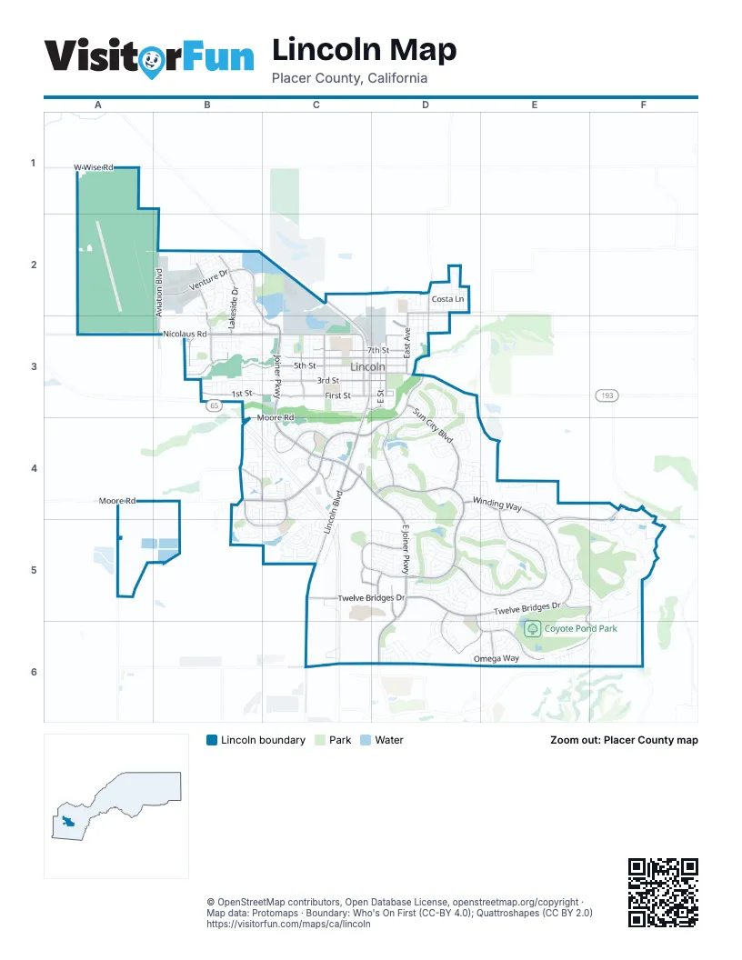
Street index of Lincoln
Each street on the sheet and the grid squares it crosses.
- Thomas J. Cosgrove Memorial HighwayB3, B4, C4, C5
- Lincoln BoulevardC2, C3, C4, C5, C6
- McBean Park DriveC3, D3
- Twelve Bridges DriveE4, F4, C5, D5, E5, F5
- East Joiner ParkwayC4, D4, D5, D6
- Joiner ParkwayB2, C3, C4
- Ferrari Ranch RoadD3, B4, C4, D4
- Nicolaus RoadA3, B3, C3
- Groveland LaneC4
- Fieldstone DriveD5
- Downing CircleC4
- Stanmark DriveC4
- Athens AvenueC6
- Nelson LaneB3
- Industrial AvenueC6
- Del Webb BoulevardD4, D5
- Spring Valley ParkwayE4, D5, E5
- Sun City BoulevardD3, D4
- Stoneridge BoulevardD4, E4, E5
- Bella Breeze DriveC5, D5
- 5th StreetB3, C3, D3
- Moore RoadA4, B4, C4
- First StreetC3, D3
- 6th StreetC3, D3
- 3rd StreetC3, D3
- Caledon CircleB4, C4, B5, C5
- Eastridge DriveD5, D6, E6
- Ridgecrest DriveE5, F5, E6, F6
- 1st StreetB3, C3
- Lakeside DriveB2, B3
- Venture DriveB2
- Aviation BoulevardB2, B3
- 7th StreetC3, D3
- South Creek DriveD5, D6, E6
- Ingram ParkwayD4
- E StreetD3
- West Wise RoadA1
- Sterling ParkwayC4
- O StreetC3
- H StreetC3
- East AvenueD2, D3
- D StreetD3
- 9th StreetC3, D3
- Colonnade DriveD5
- McCourtney RoadD2, D3
- Sorrento ParkwayB4, C4
- R StreetC3
- Virginiatown RoadD2
- Danbury DriveC4
- Fifth StreetC3
- Delegate DriveB3
- Gladding ParkwayD3
- Galewind DriveC5, D5
- Independence AvenueB3
- Bradborne LaneE6
- Waverly DriveB3
- McKean DriveB3
- Teal Hollow Drive NorthB2
- Teal Hollow Drive SouthB2, B3
- East 12th StreetD2
- McClain DriveB2
- Dresden DriveC5
- Gateway DriveC3, D3
- Camino VerderaF4, E5, F5
- Vista de MaderaE5, F5, F6
- Winding WayD4, E4
- Flightline DriveA2, A3, B3
- Brentford CircleC4, C5
- Blue Heron LoopE5
- 4th StreetC3
- Secret Lake LoopD4, D5
- Third StreetB3, C3
- Sutter View LaneE5
- 8th StreetC3, D3
- Wagon Wheel LaneD3
- Hidden Hills LaneE4
- Green Ravine DriveC4
- Kingfisher LaneE5
- J StreetC3
- I StreetC3
- Portello WayB4, C4
- Omega WayD6, E6
- Camino CieloE4, F4
- Monteverde DriveE5, F5
- Torino LoopB4, C4
- Grand Pheasant LaneE5
- Magnolia LaneD4, D5
- Black Hawk LaneE5
- Westview DriveD6
- Overland LaneD3, D4
- El Camino Verde DriveB2
- Fallen Leaf LaneD5, E5
- Lincoln Airpark DriveB2
- Larkflower WayB2
- Stoney Cross LaneC5
- Lincolnshire CircleC4
- Snapdragon LaneD4
- Parkside DriveD5
- Stonecrest LaneD5
- Cabra StreetC5, D5
- Stags Leap LaneD3, D4
- Hillwood LoopB5
- Allenwood CircleC4
- Oak Tree LaneD3, D4, E4
- Alberton CircleC4, C5
- L StreetC3
- N StreetC3
- Letterkenny DriveE5, D6, E6
- Mary Rose LaneD5
- Paseo Mira VistaE5, F5
- Swallowview DriveB2
- Prado VistaF5
- Regent CircleC4
- Ashford LaneC4, C5
- Rose Bouquet DriveD5
- Deep Springs CourtE5
- Truchard LaneD3, D4
- Monument Valley DriveD4, E4
- Stepping Stone LaneD5
- East 9th StreetD3
- Coldwater LaneD5, E5
- Stonehouse LaneD4, E4
- Business Park DriveB2, B3
- Eagles Peak LaneE5
- Gold Nugget CircleD4
- Bella CircleF5
- Floradale WayB2, B3
- Meadowland WayB2
- C StreetD3
- Q StreetC3
- 2nd StreetC3, D3
- Glenbrook LaneD5, E5
- Longspur LoopE5
- Costa LaneD2
- Paseo TranquiloF5
- Sawmill LaneD3, D4
- Carnelian CourtD5, E5
- Prairie View LaneD5, E5
- Violet LaneD4
- Stockman LaneD3, D4
- Perdita LaneD5
- La Guardia CircleB2
- F StreetD3
- Gladding RoadC2, C3
- A StreetD3
- Comstock LaneD5
- B StreetD3
- Summerhill LaneD4
- Courtyards LoopC4
- Mackinac DriveE6
- Jorgenson DriveB2
- Havenwood DriveD2
- Northfield LaneC4, D4
- Cardinal DriveD6
- Walden View LaneE5
- Castleberry LaneD4
- Lasso Lake LaneD4
- Ivy Harbor LaneD5
- Picket Fence LaneD5
- Gingersnap LaneD5
- Anastasia WayE5, E6
- Barnhill LaneC5
- Catta VerderaE5
- Topanga LaneD3
- Smoker's AlleyC3
- Nisenan Valley DriveE6, F6
- Barn Valley LaneD5
- Mariner CircleB3
- P StreetC3
- Stone Hearth LaneD5
- Oak Valley DriveD6
- Farrington LaneC4
- Homewood LaneD5, E5
- Via KarinaE5, F5
- Cottage Rose LaneD5
- Ashwood WayD2
- Seymour CircleC5
- Longhorn LaneD4
- Dapple Dawn LaneD5
- Equinox LoopC4
- Woodacre LaneE4, E5
- Hamersley LaneB4, B5
- Celtic DriveB3
- Montrose LaneC4, C5
- Briarcliff LaneD5
- Bunting LaneD6, E6
- East 10th StreetD3
- Landmark CircleC4
- Darlington WayB4, C4
- Southbridge CircleC4
- Creekcrest LaneD4, E4, D5
- Cobblestone DriveB2
- Declaration AvenueB3
- Delouch DriveB4
- Romano DriveE6
- Andover LaneD4, E4
- Fountain Hill LoopE4, E5
- Farmgate LaneD5
- K StreetC3
- M StreetC3
- Hillsdale LaneB4, B5
- Fontana DriveE6
- Crocker LaneD4, E4
- Davenport WayB4, C4
- Pebblestone LaneD5
- Rustic Ranch LaneD4
- Forebridge LaneC5
- Palo Verde WayD2
- Butterfield LaneB3, C3
- Sweet Juliet LaneD5
- Starview LaneD4, E4
- Fox Den CircleD6
- Laurelhurst LaneD5
- Patriot DriveB3
- Chambers DriveB3
- Granite LaneE4
- Culpepper LaneE6
- Abbeyhill RoadB3
- Donovan DriveB3, C3
- Rua EsperanzaF5
- Stone Pine LaneD4, D5
- Hackberry LaneD4
- Ridge Top LaneE5
- Flocchini CircleC3
- Earlton LaneB5
- Lavastone DriveD6
- Maloney DriveB3, C3
- Terra Cotta DriveC3
- Veneto WayC4
- Dogwood LoopD4
- Finney WayB2, C2
- Orange Grove TerraceE6, F6
- Savannah DriveB3
- River StreetD5
- Crystalwood CircleD3
- East 11th StreetD3
- Fuller LaneB3
- Camero DriveD6
- Daylily LaneD4
- Fairway Valley CourtD4, D5
- Nolen DriveE5, E6
- Kinnerly LaneB4, B5
- Beckwith LaneD4, E4
- Aspen Meadows WayD2
- Stansbury LaneC5
- Cinnamon Teal CourtE5
- Briarton DriveD5, D6
- Calistoga LaneD3
- Lariat LoopD4
- Stark Bridge RoadD5
- Valencia StreetD5
- Barrington LaneC4
- Chiselville LaneD5
- Avian Hill PlaceE5
- Brookside LaneC3
- Congress AvenueB3
- Zoe Ann DriveC3
- Lindbergh LaneB2
- Barnswood LoopD5
- Blackbird LaneE5
- Cross Creek LaneD2
- Newark WayB2
- Hillhaven LaneE4
- Hoitt AvenueD2, D3
- Papermill RoadD5
- Orchid LaneD4
- Granite Park DriveD6
- Rubicon LaneE5
- Poplar LaneC3
- Ainsworth LaneC4
- Sierra View CircleC4
- Laehr DriveC3
- Tiger Lily LaneD4
- Earlham LaneC5
- Coopers Hawk LaneE5
- Gatehouse LaneD5
- Milan WayB3, C3
- America DriveB3
- Sheffield LaneC4
- Flora WayC4
- Maple Grove LaneD5
- United DriveB3
- Wildomar LaneE4
- Blair Bridge RoadD5
- Lovejoy LaneD5
- Monteverde LaneF5
- Hidden Hollow LaneD5, E5
- Fawndale LaneE6
- Bartonville RoadD5
- East 8th StreetD3
- Fairway Valley LaneD4
- South Herold AvenueD3
- Glenveagh LaneE5, D6, E6
- Standish CircleC5
- Drummond LaneC4
- Periwinkle LaneD4
- Red Clover WayB2
- Old Kenmare RoadE5, E6
- Stone House CircleD4
- Avocet WayB2
Places on the map
- Aisle 1
- Aitken Ranch Park
- Aldo Pineschi Jr. Park
- ampm
- Arco
- Atkinson Park
- Auburn Ravine Dog Park
- Auburn Ravine Nature Preserve
- Bank of America
- Batting cage
- Batting Cage
- Beerman Plaza
- Bella Breeze Park
- Big 5 Sporting Goods
- Bolero
- Busey Park
- Caliber Collision
- Catta Verdera Country Club
- Courtyards Loop
- Coyote Pond
- Coyote Pond Park
- Dr. Nathan Dubin Park
- Foskett Ranch Open Space Preserve
- Foskett Regional Park
- Joiner Lake
- Joiner Park
- Lincoln High School
- Lincoln Hills Golf Club
- Lincoln Post Office
- Lincoln Regional Airport
- Mallard Pond
- Markham Park
- McBean Park
- Mill Pond
- Peter Singer Park
- PJ's Mail & Parcel
- The UPS Store
- Twelve Bridges High School
- Whistler Pond
- Wilson Park
© OpenStreetMap contributors, Open Database License, openstreetmap.org/copyright · Map data: Protomaps · Boundary: Who's On First (CC-BY 4.0); Quattroshapes (CC BY 2.0)















