

California map
Morgan Hill map
About 45,952 people live here (Census Bureau, 2024 estimate). The sheet's index lists 300 streets; Monterey Road, Butterfield Boulevard and Cochrane Road cross the most grid squares. Things to do inside the boundary: Morgan Hill Wine Trolley.
Open the map (PDF, US Letter)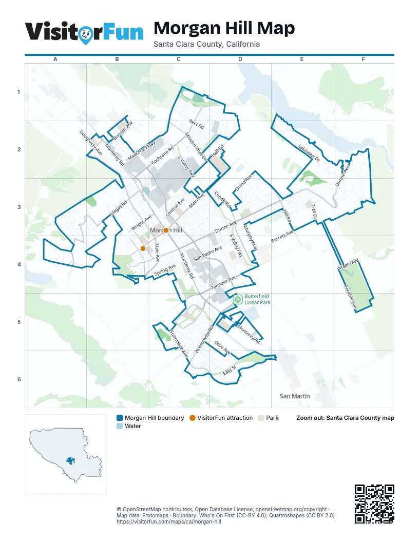
Street index of Morgan Hill
Each street on the sheet and the grid squares it crosses.
- South Valley FreewayC2, C3, D3, D4
- Monterey RoadB2, B3, C3, C4, C5, D5, E6
- Butterfield BoulevardB2, C2, C3, C4, D4, D5
- Cochrane RoadC1, D1, B2, C2, B3
- East Dunne AvenueF2, D3, E3, F3, C4
- Hale AvenueB2, B3, C3, B4, C4
- Tennant AvenueE3, C4, D4, C5
- East Main AvenueD2, C3, D3
- Hill RoadD2, D3, E3
- Watsonville RoadC5, D5, C6
- Santa Teresa BoulevardC6, D6
- West Dunne AvenueB4, C4
- West Main AvenueC3, B4, C4
- Tilton AvenueB2
- Dunne AvenueC4
- Llagas RoadA3, B3, A4
- Condit RoadD3, D4
- La Crosse DriveC5
- Vineyard BoulevardC4, D4, C5, D5
- Half RoadC2, D2
- Mission View DriveC2
- Sunnyside AvenueC5, C6
- Old Monterey RoadB2, B3
- De Witt AvenueB4
- West Edmundson AvenueC5
- Peak AvenueB3, B4, C4
- Foothill AvenueF4, F5
- Wright AvenueB3, C3
- Via VivaldiC6
- Sycamore DriveC6
- Del Monte AvenueB3, C3, C4
- Jarvis DriveC2, B3, C3
- Diana AvenueC3, D3, C4
- Sutter BoulevardC2, C3
- Serene DriveC2, C3, D3
- Barrett AvenueE3, C4, D4
- Jackson Oaks DriveF2, F3
- Murphy AvenueD3, D4
- San Pedro AvenueE3, C4, D4
- Holiday DriveE1, E2, F2, F3
- Peet RoadC1, C2, D2
- Walnut Grove DriveC3, D3, D4
- Railroad AvenueC4, D4, D5
- Madrone ParkwayB2, C2
- Thomas GradeE3, F3
- Church StreetC4
- Easy StreetD6
- East Central AvenueC3
- Spring AvenueB4, C4
- Castle Hill DriveA3
- De Paul DriveC2
- Burnett AvenueB2
- Via SebastianD1, D2
- Jasmine WayD3
- Via Santa ElenaD1, D2
- Calle MazatanC3
- Lakeview DriveE2
- Oak View CircleF3
- Fountain Oaks DriveE3
- Oak Leaf DriveE2, F2, F3
- Sycamore AvenueC1
- West Middle AvenueD5, D6
- La Alameda DriveC5, D5
- Mission AvenidaC1, C2
- Eagle View DriveC1
- Glen Ayre DriveA3, A4
- Rolling Hills DriveA4
- Olive AvenueC5, D6
- Cochrane CircleB2
- Apera LaneB3, C3
- Crest AvenueB3, B4, C4
- Native Dancer DriveC6, D6
- Encino DriveC5
- Grand Prix WayC3
- Juan Hernandez DriveD4
- Blue Jay DriveE2
- Woodland AvenueA4
- Woodview AvenueC2
- Trail DriveE3
- Saffron DriveB2
- Oakwood CourtF3
- Dougherty AvenueB2
- Mira Bella CircleE3
- Depot StreetC3, C4
- Maple AvenueF4
- Venetian WayC5, C6
- Carriage Lamp WayC3
- John Telfer DriveB4
- Kruse Ranch LaneE2, E3
- Llagas Creek DriveB3
- Peebles AvenueB2
- White Moon DriveC1, C2
- Laurel RoadC2, C3, D3
- Morning Star DriveC1, C2
- Cory DriveC4
- Via del CastilleC5
- Bel Air WayC3
- Claremont DriveB4
- Calle CentralC3
- Serra AvenueC2
- Tassajara CircleD3, E3
- Digital DriveC3
- Walnut DriveC6, D6
- Teresa LaneA3, B3
- Opal LaneB2, C2, B3
- Concord CircleD4, D5
- Holiday CourtE1, E2
- East Middle AvenueD5, F5
- Olympic DriveC4, C5
- White Cloud DriveC6
- Calle SienaC3
- Bayo Claros CircleD3
- San Ramon DriveD4
- Aventida de Los PadresC2, D2
- Bradford WayD3
- Greenwood CircleB2
- Pine WayD3
- Excalibur DriveC6
- Sorrel WayE3
- Sutter PlaceC3
- Peppertree DriveD3
- Bender CircleB3
- Malaguerra AvenueC1
- Vintage LaneD3, D4
- Castle Ridge DriveA3
- Via OristaD1, D2
- Almond WayD3
- Lancia DriveC3
- Belletto DriveC3
- Via CastanaC5
- Technology DriveC2
- La Jolla DriveC5, D5
- Calle EnriqueC5
- Saddleback DriveE3
- Bluebonnet WayD3
- Oak Park DriveB4
- Rosemary CircleC3
- Alkire AvenueB4
- Christeph DriveB3
- Shadowbrook WayB3
- Spring Hill DriveB4, C4
- Calle Buena VistaC3
- Leisure DriveC6, D6
- Calle VientoC3
- Parkview DriveE2, F2
- Kelly Park CircleD3
- Via SorrentoC5
- Creekside LaneC3, C4
- Berkshire DriveB3
- Caputo DriveD4
- Conte WayD3
- San Pedro LaneD4
- Saint Louise DriveC2
- Zinfindel CircleE3
- San Gabriel AvenueD4
- Ventura DriveC1, C2
- Oakridge RoadF2
- Saint Brendan LoopD3
- Atherton WayD6
- Montoya CircleC3
- Hacienda Valley DriveB2
- Bonnie View CourtB4
- Cosmo AvenueC4
- McLaughlin AvenueC3
- Palomares LaneB3, C3
- Carriage DriveB3
- Sabini CourtB3, B4
- Del Monte LaneB3
- Garnet LaneB2, B3
- Brega CourtE3
- Cimarron DriveE3
- Shelton WayD3
- Morgan AvenueD3
- Roble DriveC5
- Barnell AvenueC4
- Park DriveD6
- Atherton CircleD6
- Altimira CircleC1, D1, C2, D2
- Espana WayC1, D1
- Creekside CircleC3, C4
- Sorrel CourtE3
- Darnis CircleE3
- Piazza WayC5
- La Mar DriveC5
- Aspen WayD3
- Ciolino AvenueC4
- Gallop DriveE3
- Jean CourtD2, D3
- Ringel DriveD3
- Stoney Creek WayB3
- Saint Marks AvenueC1, D1
- East Edmundson AvenueC4
- Clayton AvenueB2
- Longview DriveB3
- San Luis WayC4
- Seville DriveD3
- Castle Lake DriveA3, B3
- Taylor AvenueB2
- Calle CaballeriaC3
- Curry AvenueB2
- Saint Timothy PlaceD4
- Bellini WayC6
- Alamo DriveC5
- Appian WayC5
- Cabernet CourtD3, E3
- Rebollo LaneB3, C3
- Juliann WayC3
- Coriander AvenueB2
- Via TolentinoD2
- Calle HermosaC3
- Via LomaB3
- La Rocca DriveC5, C6
- Domaine DriveD3, E3
- Pear DriveD3
- Jasper Highland DriveA3
- Hillwood LaneB3
- Via FelizB2
- Calle AstaC3
- Sara Jane LaneF2, F3
- Canopy LaneD3
- Larkspur LoopC4
- Basil AvenueB2
- St. Jean LaneB3
- White Oak CourtF2, F3
- Crystal DriveA3
- Farallon DriveB4, C4
- Calle del SolC3
- Bloom LaneD3
- San Simeon DriveC4
- Vista del ValleE3
- Brega LaneE3
- Secretariat WayC6
- Greenwood AvenueA4
- Mountainview CircleB2
- Casino RealC5
- Hay Loft WayE3
- Lindo LaneB3, C3
- Old Vine LaneD3
- Fox Hollow CircleB3
- La Selva DriveB4, C4
- La Tierra DriveC5
- Rosewood LaneD4
- Lone Hill DriveC4
- Monticello WayC5, C6
- Valley Vista CircleB2
- Mimosa DriveD3
- Heatherwood WayE3
- San Jose CourtC4
- Murphy Springs DriveB3
- Cantor DriveE3
- San Domingo DriveD4
- Garden Grove CircleB2
- Oak Canyon DriveF3
- Helene LaneF2, F3
- Mast StreetC4
- Price DriveB4
- Tarragon AvenueB2
- Calle GranadaC3
- Nob Hill TerraceC4
- Calle CerroC3
- Paprika DriveB2
- Village WayC5
- Bautista CircleC2
- Llagas Vista DriveB3
- Via GrandeB4
- Copper Hill DriveF2
- Via CorfinioC5, C6
- Rustling Oak CourtE3, F3
- John Wilson WayD5
- Bautista WayC2
- Justino DriveD2, D3
- Magnolia WayE3
- Via ContentaB2
- Bentley DriveC3
- Skipper LaneC2
- Via de NinosC5
- Via Largo CourtC5, D5
- Capistrano WayC2
- Via AmarosaB2
- McGraw AvenueC4
- Oak Hill CourtF3
- Sanchez DriveB3
- Arguello AvenueC2
- Majorca DriveD3
- Quail LaneE2
- La Arboleda WayC5, D5
- Saint Katherine DriveD1
- Santa Ines WayC2
- Crowner AvenueD5
- Silverwings CourtC1
- Saint James DriveD4
- Gallant Fox WayD6
- Badger Pass RoadD6
- Joleen WayD3, D4
- Garlic AvenueB2
- Warren AvenueC4
- Rising Sun DriveC2
- Cerro Vista DriveE3
- Almond Orchard DriveB4
- Edes CourtC4
Things to do on the Morgan Hill map
Places on the map
- 7-Eleven Store
- 7-Eleven Store, Gas & Car Wash
- ABC Learning Montessori
- Barrett Elementary School
- Britton Field
- Butterfield Linear Park
- Butterfield Self Storage
- Cal Fire Santa Clara County
- Candy Park Center
- Central High School
- Central Park
- Cochrane Business Ranch
- Cochrane Plaza Shopping Center
- Community & Cultural Center
- Davidson Ranch Reserve
- El Toro 20% Easement
- El Toro Health Science Academy
- El Toro Open Space
- El Toro Preserve
- Galvan Park
- Lake Silveira Wetlands
- Lewis H. Britton Middle School
- Live Oak High School
- Madrone Channel
- Maple Leaf RV Park
- Morgan Hill Aquatics Center
- Morgan Hill Community Park
- Morgan Hill Mini Storage
- Morgan Hill Soccer Complex
- Nob Hill
- Nordstrom Elementary School
- Oakwood School
- P.A. Walsh STEAM Academy
- PostalAnnex
- Storage Basin
- Tennant Station
- The Institute LLC
- The UPS Store
- Valley Health Center Morgan Hill
- Vineyard Town Center
Next to Morgan Hill
- San Martin
© OpenStreetMap contributors, Open Database License, openstreetmap.org/copyright · Map data: Protomaps · Boundary: Who's On First (CC-BY 4.0); Quattroshapes (CC BY 2.0)















