

California map
National City map
About 58,460 people live here (Census Bureau, 2024 estimate). The sheet's index lists 300 streets; John J. Montgomery Freeway, South Bay Freeway and East Plaza Boulevard cross the most grid squares. Also on it: Naval Base San Diego, Plaza Bonita and Pond 15.
Open the map (PDF, US Letter)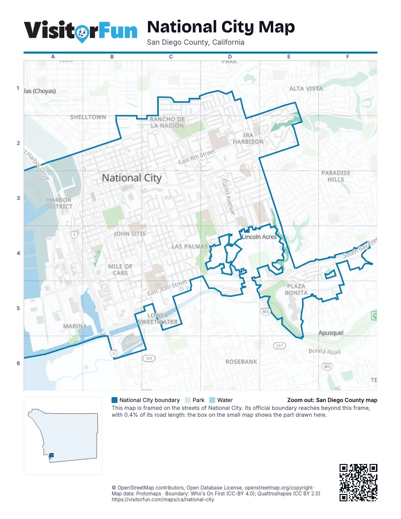
Street index of National City
Each street on the sheet and the grid squares it crosses.
- John J. Montgomery FreewayA2, A3, B3, A4, B4, B5, B6
- South Bay FreewayE4, F4, B5, C5, D5, E5
- Jacob Dekema FreewayC2, C3, D3, D4
- National City BoulevardA2, B2, B3, B4, B5
- Highland AvenueB2, B3, C3, C4, C5
- East Plaza BoulevardE1, D2, E2, B3, C3, D3
- Euclid AvenueC1, D2, D3, D4
- Sweetwater RoadD4, E4, E5, F5
- East Harbor DriveA2, A3, A4
- East 24th StreetD3, E3, B4, C4, D4
- East 30th StreetC4, D4, B5, C5
- Cleveland AvenueA4, A5
- West 8th StreetA3, B3
- Bay Marina DriveA5, B5
- Mile of Cars WayB4, B5
- Paradise Valley RoadE1, E2
- West Plaza BoulevardA3, B3
- North Highland AvenueB1, B2
- North Euclid AvenueC1
- South 43rd StreetB1
- Osborn StreetB2
- South Euclid AvenueC1
- East 8th StreetC2, D2, E2, B3, C3
- Division StreetC1, D1, A2, B2, C2
- East 18th StreetC3, D3, E3, B4, C4
- South Harbison AvenueD1, D2, E3
- Plaza Bonita RoadE5, E6
- Valley RoadE4, F4
- West 19th StreetA4, B4
- Civic Center DriveA3, B3, A4
- West 18th StreetA4, B4
- Plaza Bonita Center WayF4, F5
- West 30th StreetB5
- North Palm AvenueC2
- Main StreetA2
- Reo DriveF4
- South 47th StreetC1
- Potomac StreetE3
- D AvenueB2, B3, B4, C4, C5
- East 16th StreetB3, C3, D3, E3, B4
- East 4th StreetB2, C2, D2, B3
- Hoover AvenueB3, B4, B5
- East 7th StreetC2, D2, E2, B3
- L AvenueC2, C3, C4
- Tidelands AvenueA4, A5, A6
- Palm AvenueC2, C3, C4
- B AvenueB2, B3, B4, B5, C5
- Roosevelt AvenueA2, A3, B3, B4
- N AvenueC2, C3, C4
- East 22nd StreetD3, B4, C4
- Grove StreetD3, D4
- Rachael AvenueD2, E3, E4
- Cummings RoadA2, A3
- East 12th StreetB3, C3, D3
- Prospect StreetD3, D4
- Wilson AvenueA3, A4, B4
- East 14th StreetB3, C3, D3
- McKinley AvenueA3, A4, B4
- Coolidge AvenueA3, B3, B4
- Marina WayA5, B5
- Stockman StreetE4, F4, E5
- Granger AvenueD3, E4
- Newell StreetD3, D4
- Kidd StreetA4
- West 32nd StreetA5, B5, A6
- West 22nd StreetA4, B4
- West 14th StreetB3, A4, B4
- Olive AvenueE2
- Mole RoadA3, A4
- North 2nd AvenueD4, D5
- Ridgeway DriveD4, E4
- West 33rd StreetB5
- Shell AvenueD2, E2
- West AvenueB4
- Bonita Mesa RoadE5
- West 23rd StreetA4, B4
- North Harbison AvenueD1
- Salot StreetE2
- Cervantes AvenueD1
- Alleghany StreetE3
- Albemarle StreetE3
- West 4th StreetA3, B3
- West 7th StreetB3
- Olivewood DriveC4
- South 40th StreetB2
- Mariposa PlaceD2
- Yama StreetA2
- East 20th StreetC3, D3, E3, B4, C4
- J AvenueB2, C2, C3, C4, C5
- F AvenueB2, B3, B4, C4, C5
- East 5th StreetB2, C2, D2, B3
- K AvenueC2, C3, C4, C5
- East 6th StreetB2, C2, D2, B3
- A AvenueB2, B3, B4, B5
- Ring RoadE5
- East 1st StreetD1, B2, C2, D2
- East 2nd StreetD1, B2, C2, D2
- C AvenueB3, B4, B5, C5
- I AvenueB2, B3, C3, C4, C5
- East 17th StreetC3, D3, E3, B4
- E AvenueB2, B3, B4
- East 9th StreetC2, D2, B3, C3
- East 3rd StreetB2, C2, D2
- South Lanoitan AvenueD1, D3
- East 15th StreetB3, C3, D3, B4
- Harding AvenueA3, B4, B5
- East 26th StreetB4, C4
- G AvenueB2, B3, C3, C4
- East 28th StreetC4, B5
- Cagle StreetE4, F4
- Beta StreetC1, D1
- Terminal AvenueA5, A6
- East 11th StreetD2, B3, C3, D3
- East 21st StreetB4, C4
- M AvenueC2, C3, C4
- Orange StreetD3, D4, D5
- Womble StreetA4
- Brinser StreetA3
- Manchester StreetE2
- Quay AvenueA5
- East 10th StreetC2, D2, C3
- Delta StreetB1, C2
- Melrose StreetD1, B2, C2
- R AvenueC2, C3
- East 19th StreetD3, E3, C4
- West 28th StreetA5, B5
- La Siesta WayD3, D4
- South V AvenueC2, D2
- Transportation AvenueB4, B5
- West 12th StreetA3, B3
- O AvenueC3, C4
- West 16th StreetA4, B4
- East 13th StreetC3, D3
- Paradise DriveC2, D2, D3
- Arcadia PlaceD2
- Haffley AvenueA4, A5
- Woden StreetA3
- West 15th StreetA4, B4
- Q AvenueC2, C3
- G StreetE4
- Van Ness AvenueE3
- Newberry StreetE4, F4
- Mc Candless RoadA2, A3
- Fairlomas RoadE5, F5
- South Drexel AvenueD1, D2
- South Kenton AvenueD1, D2
- Paseo de FuentesE5, F5
- Recreation WayA3
- Cherry Blossom StreetE1, E2
- Street pathF4
- San Miguel CourtF4
- Peach Blossom StreetE1
- Earle DriveD2, D3
- Laurel AvenueC2
- Gamma StreetC1
- Southport WayB4, B5
- West 17th StreetA4, B4
- T AvenueC2
- Alpha StreetC1
- East 27th StreetC4, B5
- Harbison AvenueE3
- South U AvenueC2
- Southall StreetA3
- West 11th StreetA3, B3
- Palmer StreetD2, D3
- Angelo DriveE2
- West 35th StreetB6
- West 20th StreetA4, B4
- South Belmont AvenueD1, D2
- Hill DriveD2
- Menard StreetE4, E5
- Ravencroft AvenueA2, A3
- Norton AvenueC2
- Hollyhock LaneE1, E2
- South Clairmont AvenueD1, D2
- East 31st StreetB5, C5
- Via RomayaF4, F5
- Via Las PalmasD4
- East 23rd StreetC4
- Soltura LaneB2
- North Clairmont AvenueD1
- North R AvenueC1, C2
- Delta Park LaneB2
- Fig CourtB2, C2
- North Drexel AvenueD1
- West 26th StreetB4, B5
- Scott DriveB2, C2
- Calle AbajoE4
- North T AvenueC1, C2
- Norfolk StreetC1, D1
- Channel LaneA3
- Vesta StreetA3
- Mc Kinley AvenueA3
- West 21st StreetB4
- Williamson WayA2, A3
- Biggs CourtE5
- La Posada StreetC1
- Kimball WayB3
- Goesno PlaceA5, A6
- North U AvenueC1, C2
- Taft AvenueA3
- Ethel PlaceE2
- Eta StreetB2
- Virginia DriveC4
- Bucky LaneB2
- Surface Navy BoulevardA3
- Valva AvenueD1, D2
- Lincoln CourtD4
- North Belmont AvenueD1
- Valle Vista AvenueD3
- Leonard StreetE3, E4
- Roselawn StreetC4
- Palmer WayD2, D3
- Kaplan WayF4, F5
- Pleasant LaneD2
- Thelma WayD2
- Tolas CourtE2
- Paseo de PazF5
- Ranger RoadE2
- West 25th StreetB4
- Mariposa CircleC2
- North Kenton AvenueD1
- West 9th StreetA3, B3
- Eleanor PlaceE2
- Cumberland StreetE3
- Honeysuckle LaneE1
- Sheryl LaneC3
- Harbison PlaceD2
- Alston AvenueE4
- Calmoor StreetF5
- Lou StreetD2, E2
- Magnolia WayD1
- Mesa AvenueD1
- Cypress StreetE5
- North Lanoitan AvenueD1
- A StreetB2
- Lynda PlaceF4
- Shaw StreetE3
- Alta DriveE4
- Sabine CourtE4
- Ships Park BoulevardA4
- East 29th StreetC5
- Smith StreetA4
- Amphibious BoulevardA4
- Dewey StreetA4
- Fairlindo WayF4, F5
- Destroyer AlleyA4
- Canyon Ridge DriveE4
- Jasmine StreetE4
- Kellie CourtE4, F4, E5
- Palm View DriveC3
- Gretchen WayE4
- Roanoke StreetE3
- Fenton PlaceD4
- Winchester StreetE3
- Meadow DriveD3
- Paradise AvenueE2
- Mary LaneE2
- Morning Breeze LaneD3
- B StreetE4
- Seawind DriveD3
- Paraiso CourtC2
- Stancrest LaneD3
- Mann AvenueC1
- 14th StreetD3
- Stacey CourtE4
- North S AvenueC1, C2
- Balsam DriveB2
- Edgerton WayC3
- Rose DriveB4, C4
- Alberta CourtB2
- Canna DriveB2
- Dahlia DriveB2
- Elm DriveB2
- Flower DriveB2
- Harbison WayD2
- Shelby DriveD4
- West 5th StreetB3
- C StreetE4
- East 25th StreetB4
- West 2nd StreetA2, B2
- West 3rd StreetA2, B2
- Burden DriveD2
- Calmoor WayF5
- South 41st StreetB2
- Gladiola DriveB2
- Sito LaneB2
- North Q AvenueC1, C2
- Buttercup LaneE1, E2
- Paseo de SabatoF5
- Mary CourtE2
- 4th StreetA3
- Moda LaneB2
- Bolivar StreetE3
- Carol PlaceE2
- West Division StreetA2
- Casa PlaceD3
- Sabine WayD4, E4
- Calle DelgadoD3
- Tapa LaneB2
Places on the map
- 24th Street
- El Toyon Park
- Ethel Hill
- Granger Junior High
- Harbison Elementary School
- Kimball Park
- Las Palmas Park
- MWR
- National City Golf Course
- National City Middle School
- National City Post Office
- Naval Base San Diego
- Olivewood School
- Palmer Way School
- Paradise Valley Hospital
- Pepper Park
- Plaza Bonita
- Plaza Towne Shooping Center
- Pond 15
- Rancho de la Nación Elementary
- South Bay Marketplace
- Sweetwater River
- Sweetwater Union High School
- Westfield Plaza Bonita
Next to National City
- Alta Vista
- Apusquel
- Las Chollas (Choyas)
- Lincoln Acres
- Lynwood Hills
- Paradise Hills
- Rosebank
- Shelltown
- South Crest
- Sunny Vista
- Third Avenue Village
© OpenStreetMap contributors, Open Database License, openstreetmap.org/copyright · Map data: Protomaps · Boundary: Who's On First (CC-BY 4.0); Quattroshapes (CC BY 2.0)















