

California map
Redding map
About 93,502 people live here (Census Bureau, 2024 estimate). The sheet's index lists 300 streets; Old Oregon Trail, Shasta View Drive and Cascade Wonderland Highway cross the most grid squares. Things to do inside the boundary: Bricks & Minifigs Redding and Redding Public Market.
Open the map (PDF, US Letter)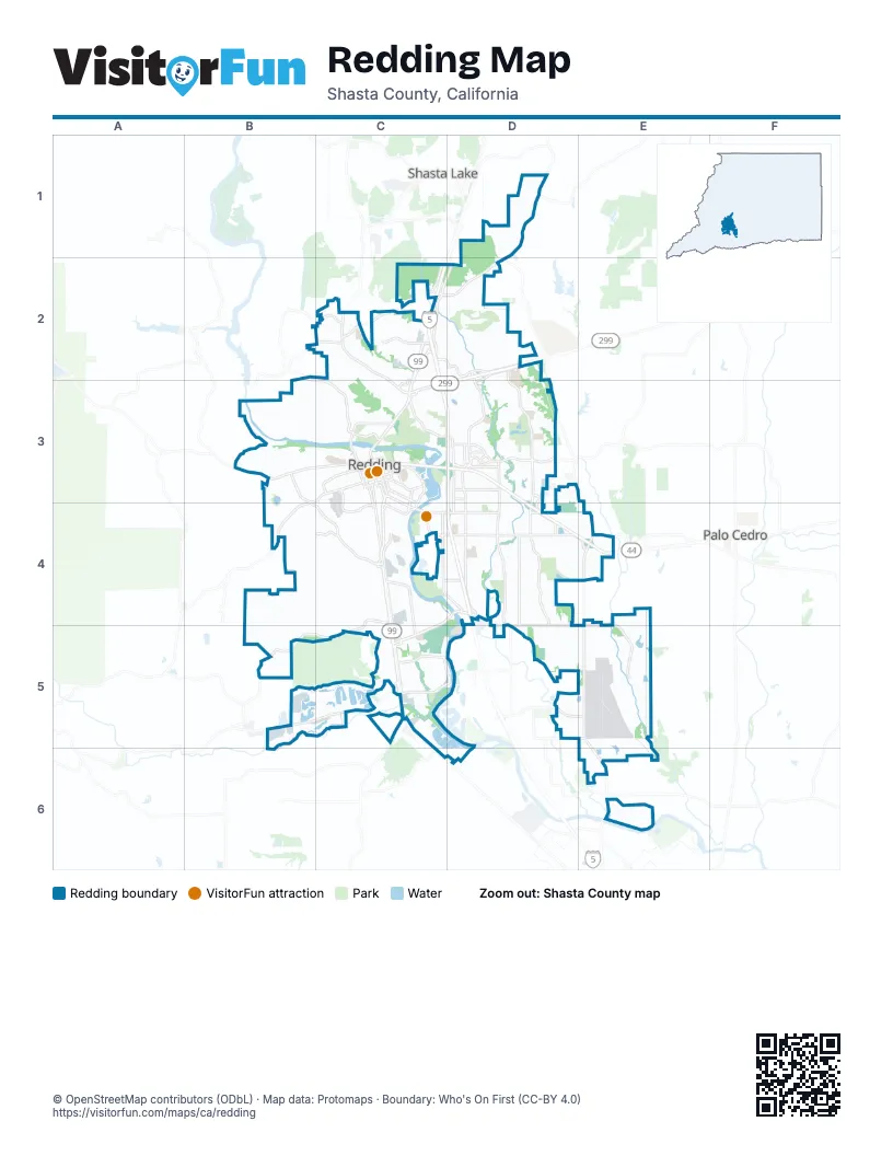
Street index of Redding
Each street on the sheet and the grid squares it crosses.
- Cascade Wonderland HighwayC2, C3, D3, D4
- Trinity Scenic BywayD2, D3
- South Market StreetC3, C4, C5
- Old Oregon TrailD1, D2, D3, E3, E4, E5
- North Market StreetC2, C3
- Lake BoulevardC2, C3, D3
- Airport RoadE4, E5, E6
- Eureka WayB3, C3
- Branstetter LaneC4, B5, C5
- Cypress AvenueC3, C4
- Shasta StreetC3
- California StreetC3, C4
- Gold StreetC3
- East StreetC3, D4
- Pine StreetC3
- Parkview AvenueC3, C4
- Tehama StreetC3
- Market StreetC3, C4
- Shasta View DriveD2, D3, D4, D5, E5
- Churn Creek RoadD3, D4, D5
- Hilltop DriveC3, D3, D4
- Hartnell AvenueC4, D4, E4
- Buenaventura BoulevardB3, B4, C4
- South Bonnyview RoadC4, D4, C5
- Bechelli LaneC3, C4, D4
- Oasis RoadD1, C2, D2
- Quartz Hill RoadB2, C2, B3, C3
- Victor AvenueD3, D4, D5
- Clear Creek RoadB5, C5
- Placer StreetB3, C3, B4
- Old Alturas RoadD3
- East Cypress AvenueC4, D4
- Rancho RoadD5, E5
- Alta Mesa DriveD4, D5
- Railroad AvenueC3, C4
- College View DriveD2, D3
- Park Marina DriveC3, C4
- Dana DriveD3
- Placer RoadB4
- Butte StreetC3
- Court StreetC3, C4
- Hawley RoadD2, D3
- Sundial Bridge DriveC3
- Athens AvenueC3, C4
- Canyon Creek RoadC4
- Knighton RoadD5, E5
- Continental StreetC3
- Meadow View DriveD5, E5
- Friendly RoadD3
- Knigthon RoadE5
- Schley AvenueC3, C4
- South Bonnyview LaneD4
- Eastside RoadC4, C5, C6
- Twin View BoulevardC2, D2, C3
- Westside RoadC4, C5
- West StreetC3, C4
- Collyer DriveD2
- Goodwater AvenueD4, D5
- Sacramento DriveC5
- South StreetC3
- Venture ParkwayE5
- Benton DriveC3
- Canby RoadD3
- Tarmac RoadD3, D4
- Riverside DriveC3, C5, D5
- Caterpillar RoadC2
- East Bonnyview RoadC4, C5
- Mistletoe LaneD3
- Browning StreetD3
- Yuba StreetC3
- Texas Springs RoadB5
- Airpark DriveC3, C4
- Keswick Dam RoadB2, C2
- Girvan LaneC5
- Teton DriveB4, C4
- Cascade BoulevardC2
- Locust StreetC3, C4
- Loma Vista DriveC4, D4
- Old 44 DriveD4, E4
- Mountain View DriveC2, D2
- Willis StreetC3
- Canyon RoadC5
- Industrial StreetD3
- Sequoia StreetC3
- Liberty StreetC3
- Radio LaneC4
- Northpoint DriveC2, C3
- Island DriveC5, D5
- Lancers LaneD3
- Rosaline AvenueC4
- North Court StreetC3
- Pleasant StreetC3
- Polk StreetC4
- Star DriveC5
- Angelo AvenueC4
- 11th StreetC3
- Sheridan StreetC4
- Redding Rancheria RoadC5
- Wortley LaneC5
- Bear Mountain RoadD1
- Lockheed DriveE5
- Cedars RoadC4, C5
- River Park DriveC3
- Lakeside DriveB3, B4
- Abernathy LaneD3, D4
- Howard DriveC4
- Riviera DriveC4
- Gold Hills DriveD2
- Hollow LaneD2
- Kenyon DriveC4
- Redwood BoulevardC2
- Beltline RoadC2
- Panorama DriveC2, C3
- Galaxy WayD4
- Springer DriveD3
- Hope LaneD2
- Harlan DriveB3, C3
- Mountain Lakes BoulevardC2
- Sonoma StreetC3, C4
- Saratoga DriveD4, D5
- Tierra Heights RoadD1
- Grouse DriveD3
- Cumberland DriveB4, C4
- Marlene AvenueD4
- Creekside StreetC5
- Larkspur LaneD3, D4
- Sunglow DriveB4, C4
- Lake Redding DriveB3, C3
- Akrich StreetD1, D2
- Henderson RoadC4
- Western Oak DriveD4
- Foothill BoulevardB3, C3
- Preserve BoulevardD4, E4
- Wilson AvenueD4
- Starlight BoulevardC4
- Hawn AvenueD4
- Sacramento StreetC3
- Pit RoadC5
- Magnolia AvenueC3
- Venus WayD4
- Lawrence RoadD4
- Edgewood DriveD3
- El Verano StreetD4
- Argyle RoadD4, E4
- Capricorn WayD4
- Woggon LaneC2
- Ridgewood RoadD2
- Viking WayD3, E3
- Pioneer DriveB3, C3
- Alfreda WayD3, D4
- Hemlock StreetC5
- Redbud DriveB3
- Wyndham LaneC4
- Wisconsin AvenueB3, B4
- Riverview DriveC4
- Royal Oaks DriveB3, C3
- North Bonnyview RoadC4
- Mission de Oro DriveD3
- Overhill DriveC3
- Lucky LaneD3
- Brittany DriveD4
- Gibralter RoadD3
- Palacio DriveD3
- Oak Mesa LaneD3
- Alicia ParkwayD1
- Reddington DriveD3
- Forest Hills DriveD4
- Summit DriveC4
- Arboretum DriveC3
- Tralee LaneB4
- Trumpet DriveD3
- Santa Cruz DriveB3
- Oxford RoadD3, D4
- Simpson BoulevardD3
- Templeton DriveD4
- Lincoln StreetC3
- Fig Tree LaneE6
- Chestnut StreetC3, C4
- Whistling DriveD3
- Saturn SkywayD4
- Cheryl DriveC4
- River Ridge DriveB3, C3
- Oro StreetB3, B4
- Pioneer LaneC4
- Barbara RoadC3
- Ellis StreetC4
- El Vista StreetD4
- Haleakala AvenueB3
- Waldon StreetC3, C4
- Magnums WayC2
- Roseland StreetD3
- Woodhill DriveC3
- Mullen ParkwayC5
- C StreetD4
- Mountain Shadows BoulevardC2
- Ridge DriveB3
- Constitution WayC2, D2
- Laver StreetD4, E4
- Valley View RoadC5
- Lynbrook LoopE4
- Mill Valley ParkwayD3
- Vineyard TrailD3
- Reflection StreetC5
- California-Market AlleyC3
- Walnut AvenueC3
- White River DriveC2
- Alta Saga DriveD4
- Almond AvenueC3
- Garden AvenueC3
- Veda StreetC4
- Harpole RoadD4
- Olive AvenueC3
- Skyline DriveC3, C4
- Devere RoadD5, E5
- Belladonna StreetD4
- Orange AvenueC3
- Yana AvenueD4
- Twin Tower DriveD2
- Hemingway StreetD3
- Blue Bell DriveC4
- Leonard StreetD4
- Irwin RoadD4
- Reservoir LaneD4
- Sunriver LaneB3
- Valleyridge DriveC2
- Eagle ParkwayC4, D4
- Woodbury DriveD4
- Candlewood DriveD3
- Sutro Mine RoadB3
- Nicolet LaneC4
- Entry DriveD2, D3
- Heather LaneD4
- Oregon StreetC3
- Platinum WayC5
- Delta StreetC3
- Alta Camino DriveD4, D5
- Kildare DriveB3, B4
- Yellowstone DriveD4
- Dusty LaneD3
- Shastina StreetD3, D4
- 8th StreetC3
- Municipal BoulevardE5
- Castlewood DriveD4
- Hemsted DriveC4
- Peppertree LaneC3
- Polaris WayD4
- Indianwood DriveC4, D4
- Scenic DriveB3
- Trinity StreetC3
- Yolla Bolly TrailD3
- Pine–East Street AlleyC3
- View AvenueD3
- Santa Rosa WayC2
- Arizona StreetD4
- Record LaneB4
- Wilshire DriveC4
- Woodside Meadows DriveD3
- Lower Springs RoadB3
- Gordon LaneD4
- Old Lantern DriveB2, B3, C3
- Alta Campo DriveD4
- Lowden LaneC4
- Woodcliff DriveC3
- Partridge DriveD3
- Tradition WayC4
- Saint Andrews DriveD2
- Amethyst WayC3
- Beaumont DriveD2
- Mercury DriveD4
- Washington AvenueC3
- River Bend RoadC3
- Alden AvenueD4
- Hardwood BoulevardC2
- State StreetC4
- Amigo WayD5
- Freebridge StreetC4
- Rugby Hill DriveD2
- Bowyer BoulevardD4
- Bodenhamer BoulevardD3
- Crossroads DriveE4
- Lake Forest DriveC2
- Randolph RoadC2
- Huntington DriveD4, D5
- Modoc LaneD3
- Palisades AvenueC3
- Lakewood DriveC5
- Winding WayC2
- Hole in One DriveE6
- North Boulder DriveC2, C3
- Eagle Nest RoadC2
- Cirrus StreetD4
- Charade WayD3
- Canal DriveC3
- Wasatch DriveB4
- Center StreetC3
- Arcade WayD4
- Inspiration PlaceD3
- Emerald LaneC5
- Echo RoadD4
- El Camino DriveC5
Things to do on the Redding map
Places on the map
- All-Preferred Mini Storage
- Allen’s Golf Course
- Alta Mesa Elementary School
- Axner Excavating Ink
- Benton Field
- Benton Landfill
- Best Value Mini Storage
- Big League Dreams
- Bonny View Elementary School
- Buckeye Elementary School
- Caldwell Park
- Cascade Park
- Caterpillar Road Storage
- Churn Creek Marketplace
- Churn Creek Retail Center
- Clover Creek Preserve
- CrossPointe Community Church
- Crown Motors
- Cypress Pointe
- Enterprise Community Park
- Gold Hills Golf Club
- Hilltop Towne Center
- Kutras Pond
- Lema Ranch
- McConnell Botanical Gardens
- North Point Plaza
- Nur Pon Open Space
- Oak Savannah Arboretum
- Peppertree Natural Area Park
- Premier RV Park
- Redding Dragstrip
- Redding Memorial Park
- Redding Soccer Park
- Redding Veterans Home
- River Crossing Marketplace
- Riverview Golf & Country Club
- Sell Lumber Corporation
- Shasta Crossroads Center
- Turtle Bay East
- Turtle Bay Exploration Park North
Next to Redding
- Bella Vista
- Palo Cedro
- Shasta Lake
© OpenStreetMap contributors, Open Database License, openstreetmap.org/copyright · Map data: Protomaps · Boundary: Who's On First (CC-BY 4.0); Quattroshapes (CC BY 2.0)