

California map
Sacramento map
About 535,798 people live here (Census Bureau, 2024 estimate). The sheet's index lists 120 streets; Westside Freeway, Golden State Highway and North Sacramento Beltline Freeway cross the most grid squares. Things to do inside the boundary: MOSAC (SMUD Museum of Science and Curiosity), The California Museum and Visit California.
Open the map (PDF, US Letter)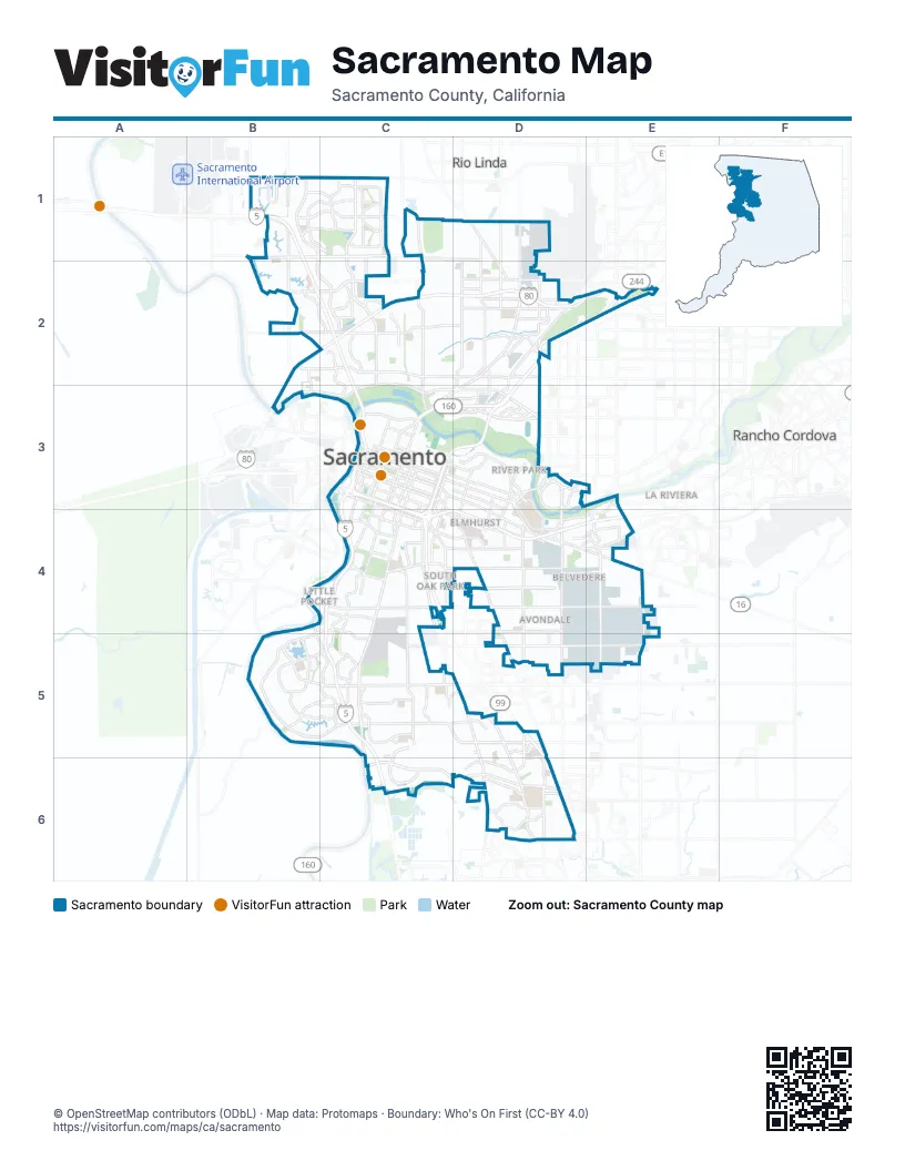
Street index of Sacramento
Each street on the sheet and the grid squares it crosses.
- Del Paso RoadB1, C1
- East Commerce WayB1, B2, C2
- El Centro RoadB1, B2
- Golden State HighwayB1, C3, C4, D5, D6
- West Elkhorn BoulevardB1, C1
- Westside FreewayB1, B2, C2, C3, C4, C5, C6
- Main AvenueC1, D1
- Natomas BoulevardC1
- Truxel RoadC1, C2
- Marysville BoulevardD1, D2
- Norwood AvenueD1, D2
- Rio Linda BoulevardD1, D2
- Arena BoulevardB2, C2
- North Sacramento Beltline FreewayB2, C2, D2, E2, B3
- San Juan RoadB2, C2
- West El Camino AvenueB2, C2
- El Camino AvenueC2, D2
- Garden HighwayC2, B3, C3
- North Market BoulevardC2
- Northgate BoulevardC2, C3
- Silver Eagle RoadC2, D2
- Auburn BoulevardD2, E2
- Bell AvenueD2
- Capital City FreewayD2, E2, C3, D3, C4
- Connie DriveD2
- Del Paso BoulevardD2, C3
- Fulton AvenueD2
- Grove AvenueD2, D3
- Lampasas AvenueD2
- Longview DriveD2, E2
- Marconi AvenueD2
- Raley BoulevardD2
- Rio Altos AvenueD2
- Roseville RoadD2
- Santiago AvenueD2
- Winters StreetD2
- Watt AvenueE2, E3, E4
- 12th StreetC3
- 15th StreetC3
- 16th StreetC3, C4
- 19th StreetC3, C4
- 21st StreetC3, C4
- 29th StreetC3, C4
- 30th StreetC3, C4
- 3rd StreetC3
- 5th StreetC3
- 7th StreetC3
- 9th StreetC3
- Alhambra BoulevardC3, C4
- Arden WayC3, D3
- Arden-Garden ConnectorC3
- BroadwayC3, C4, D4
- Capitol AvenueC3
- Capitol MallC3
- Folsom BoulevardC3, D3, D4, E4
- G StreetC3
- H StreetC3, D3
- I StreetC3
- J StreetC3, D3
- Jimboom StreetC3
- Kiline StreetC3
- L StreetC3
- N StreetC3
- North 12th StreetC3
- North 16th StreetC3
- North 7th StreetC3
- North Sacramento FreewayC3, D3
- P StreetC3
- Q StreetC3
- Richards BoulevardC3
- Riverside BoulevardC3, C4, B5
- South Sacramento FreewayC3, C4
- Stockton BoulevardC3, C4, D4, D5
- Tower BridgeC3
- W StreetC3, C4
- X StreetC3, C4
- 57th StreetD3
- Alta Arden ExpresswayD3
- Arden Way BypassD3
- Carlson DriveD3
- El Monte AvenueD3
- Elvas AvenueD3, D4
- Ethan WayD3
- Exposition BoulevardD3
- Fair Oaks BoulevardD3
- Heritage LaneD3
- Howe AvenueD3, D4
- State University DriveD3
- 12th AvenueC4
- 12th Avenue BypassC4
- 14th AvenueC4, D4
- 43rd AvenueC4, B5
- El Dorado FreewayC4, D4, E4
- Franklin BoulevardC4, C5, D5, D6
- Freeport BoulevardC4, C5
- Fruitridge RoadC4, D4, E4
- Land Park DriveC4
- Seamas AvenueC4
- Sutterville RoadC4
- 65th StreetD4
- 65th Street ExpresswayD4, D5
- College Town DriveD4
- Jackson RoadD4, E4
- Power Inn RoadD4, D5
- Ramona AvenueD4
- Florin Perkins RoadE4, E5
- South Watt AvenueE4, E5
- Florin RoadB5, C5
- Pocket RoadB5, C5
- Mack RoadC5, D5
- Meadowview RoadC5
- 47th AvenueD5
- Alta Valley DriveD5
- Bruceville RoadD5, D6
- Center ParkwayD5, D6
- Elder Creek RoadD5
- Valley Hi DriveD5
- Cosumnes River BoulevardC6, D6
- Calvine RoadD6
- Sheldon RoadD6
Things to do on the Sacramento map
Places on the map
- 2020 Gateway
- 3310 Apartments
- ADESA Sacramento
- Alhambra Triangle
- Alkali Flat
- Annex Project
- Arden Fair Mall
- Avondale
- Bel Lago
- Belvedere
- Bing Maloney Golf Club
- Boulevard Park
- Brentwood
- Broadleaf Apartments
- BT Collins Army Reserve Center
- Cal Expo
- Cal Expo Monorail
- California State University - Sacramento
- Campus Commons
- Campus Commons Golf Course
- Capitol Park
- Carefree Senior Apartments
- Carleton Tract
- Central Oak Park
- College Greens Shopping Center
- College Town
- College/Glen
- Colonial Heights
- Colonial Manor
- Colonial Village
- Copperstone Village
- Curtis Park
- Del Paseo Corporate Center
- Del Paso Park
- Delta Pointe Apartments
- Delta Shores
- Depot Park
- Discovery Park
- Downtown
- East Lawn Memorial Cemetery
Next to Sacramento
- La Riviera
- Rancho Cordova
- Rio Linda
- West Sacramento
© OpenStreetMap contributors (ODbL) · Map data: Protomaps · Boundary: Who's On First (CC-BY 4.0)