

California map
San Carlos map
About 29,403 people live here (Census Bureau, 2024 estimate). The sheet's index lists 300 streets; Alameda de las Pulgas, Brittan Avenue and Industrial Road cross the most grid squares. Also on it: Big Canyon Park, Arguello Park and Eaton Park.
Open the map (PDF, US Letter)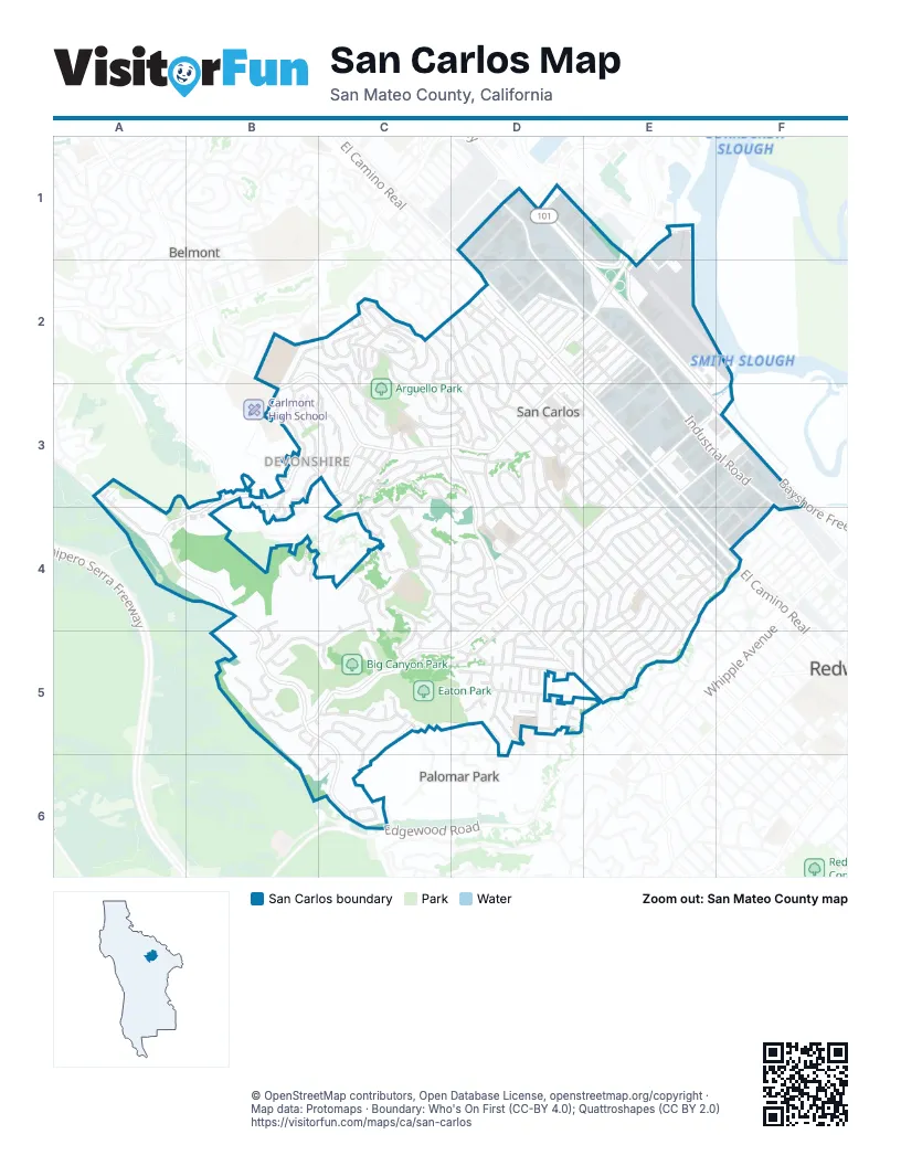
Street index of San Carlos
Each street on the sheet and the grid squares it crosses.
- Bayshore FreewayD1, E2, E3, F3
- El Camino RealD2, D3, E3, E4, F4
- Brittan AvenueE3, D4, E4, B5, C5, D5
- Industrial RoadD1, D2, E2, E3, F3, F4
- Crestview DriveA3, A4, B4, B5, C5, C6
- Old County RoadD2, E3, E4, F4
- San Carlos AvenueB2, C2, D2, B3, C3, D3
- Alameda de las PulgasB2, B3, C3, D3, D4, D5, E5
- Holly StreetD2, E2, D3
- Industrial WayF4
- Laurel StreetD2, D3, E3, E4, F4
- Howard AvenueE3, F3, D4, E4, D5
- Club DriveB3, A4, B4
- Skyway RoadE1, E2, E3
- Shoreway RoadD1, E1, E2
- Beverly DriveB3, C3
- Witheridge RoadB3
- Pico BoulevardE1
- Cedar StreetC2, D2, D3, D4, E4, E5
- Elm StreetD2, D3, E3, E4
- Eaton AvenueE4, F4, D5, E5
- Chestnut StreetD2, D3, D4, E4
- Melendy DriveC4, D4, B5, C5
- Walnut StreetD2, D3, E3, E4, F4
- Cordilleras AvenueD3, D4, E4, D5, E5
- Saint Francis WayE4, F4, E5
- Dartmouth AvenueB2, C2, B3
- La Mesa DriveC5, B6, C6
- Greenwood AvenueE3, D4, E4
- Orange AvenueD3, D4, E4
- Arroyo AvenueD3, E3, D4
- Bayview DriveB3, C3, B4
- Carmelita DriveC3, D3
- Wellington DriveB2, C2, C3
- Hillcrest RoadC2, C3, D3
- White Oak WayE4
- Exeter AvenueB3, C3
- Sunset DriveD4
- Tamarack AvenueD3, D4
- Cherry StreetE2, D3, E3
- Belmont AvenueE4
- Bayport AvenueD2, E2, E3, F3, F4
- Coronado AvenueC3, C4
- Shelford AvenueC2, C3
- Lupin WayD4
- Woodland AvenueD3, E3, E4
- Highland AvenueC2, C3, D3
- Clifton AvenueC2, C3
- Oakview DriveD4, E4, D5
- Rosewood AvenueD3, E3, E4
- Buckland AvenueC2
- Northam AvenueC2, C3
- Hewitt DriveC4, D4, C5
- Knoll DriveD3, D4
- Emerald AvenueD4, D5, E5
- Elizabeth StreetD3, D4
- Park AvenueE4, E5
- Arundel RoadC3, D3
- American StreetF3, E4
- Hull DriveC2, D2
- Devonshire BoulevardC3
- Sycamore StreetC2, D3
- De Anza AvenueD5
- Madera AvenueC3, D3
- Greenbrier RoadB5, C5
- Bransten RoadE2, E3
- East San Carlos AvenueD2, E2
- Prospect StreetC2, D3
- Graceland AvenueD4, D5
- Bauer DriveD4
- Edgehill DriveD4, E4, D5
- Portofino DriveC4
- Kelton AvenueE4, E5
- Magnolia AvenueD2, D3
- Belle AvenueD4
- Oakhurst AvenueE4
- Vine StreetC2, D2, D3
- Quarry RoadD1, D2
- Alberta AvenueE4, E5
- Hilltop DriveD5
- Morse BoulevardE3
- Fairmont AvenueE4, E5
- Rockridge RoadD4
- Ruby AvenueE5
- Phelps RoadC3
- Pearl AvenueE4, E5
- Glasgow LaneC4
- Terminal WayE2, E3
- Hall StreetE2, E3
- Bing StreetF3, F4
- Mc Cue AvenueD2, E2
- Commercial StreetE3
- Montgomery StreetD2, E2
- Washington StreetF3, E4, F4
- Fay AvenueC3, C4
- Center StreetE3, F3, E4
- Garnet AvenueE5
- Mesa Verde WayC5
- Plymouth AvenueC3
- Tramanto DriveC4, C5
- Belvedere AvenueE4
- Birch AvenueD4
- Sunnydale AvenueE4
- Eucalyptus AvenueD4
- Manor DriveC3
- Taylor WayD2
- Trillium LaneA3, A4
- Wildwood AvenueD4, D5
- Exbourne AvenueC2
- Porto Marino DriveC4, C5
- Hill WayD5
- Loma RoadC5
- Torino DriveC4
- Fairfield DriveD2
- Leslie DriveB5
- Vista del GrandeC3, D4
- Hemlock StreetD3, D4
- Bromley DriveD5
- Vista AvenueD3
- Lynton AvenueB3, B4
- Springfield DriveD2
- Olive StreetD3, E3
- Sylvan DriveD2
- Windsor DriveC3, C4
- Manzanita AvenueD2, D3
- Maple WayD5
- Aberdeen DriveC4
- Heather DriveC4, D4
- Pine AvenueC3, D3
- Clifford AvenueD5
- Roslyn AvenueC4
- Central AvenueE4, F4
- Tulip LaneB4
- Royal LaneB5
- Cranfield AvenueB3
- Queens CourtB4
- Sherwood DriveD5
- Inverness DriveD2
- Riverton DriveD2
- Tanklage RoadE2, E3
- Edmond DriveC6
- Bragato RoadD1, D2
- Dolton AvenueB4
- Ridge RoadD5
- Ensenada RoadC2
- Hartford AvenueC2
- Airport WayE2
- Glenn WayD2
- Lyndhurst AvenueC2
- Bayside BoulevardF3
- Colton AvenueE4, E5
- Wessex WayC3
- Debbie CourtD5
- Erlin DriveC2
- Geneva AvenueE4
- Dale AvenueC3
- Palm AvenueC3, D3
- Chilton AvenueB3
- Gover LaneE4
- Hallmark DriveA3
- Timothy DriveD5
- Roland AvenueD5
- Dayton AvenueD4
- Los Vientos WayB4, B5
- Thornhill DriveD5
- Baytree RoadD3, E3
- Frances LaneD5
- Hyde Park EstatesC4
- Molton AvenueC3
- Buttercup LaneA3, A4
- Oak Creek LaneD5
- Fleetwood DriveC6
- Drake CourtC5
- Hyde Park AvenueB4
- Camborne AvenueB3
- Northwood DriveD2
- Valley RoadC2, D2
- Varian StreetE4, F4
- G StreetF4
- Sequoia CourtB3
- Bayport CourtD2, E2
- Brook StreetD4
- Madrona StreetC3
- Robin WayD5
- Coleman CourtC3, C4
- Alma StreetD3
- Coventry CourtB5
- Terrace RoadD5
- Bush StreetD2
- Normandy CourtB4, B5
- Kings CourtB4
- Nanette DriveC4, D4
- Lyndhurst CourtC2
- Arch LaneC2
- Spring StreetD2
- Azalea LaneA4, B4
- Cobblestone LaneD5
- Glenwood StreetD2, D3
- Fir StreetD2
- Oak StreetD2
- F StreetD2
- Regent CourtB5
- Granite CourtD5
- Chicory LaneA4
- Lemoore DriveD5
- Pebble DriveC5, C6
- Barford AvenueC2
- Porto Marino LaneC4
- Cabot CourtC5
- Cherry LaneE2
- Cottage LaneC2
- Clover LaneB4
- Exeter WayC3
- Monte Vista DriveE2
- Cambridge StreetC3
- Elston CourtC4
- Calypso LaneB4
- Del Rey CourtC3
- Neal AvenueD5
- Quail LaneB4, B5
- Fairbanks AvenueD4
- Winding WayC4
- Oakley AvenueB3, B4
- Victoria ManorD5
- Daffodil LaneB4
- Stanford LaneE4
- Kent AvenueB4, B5
- Wilshire CourtD4
- Eaton Villa PlaceD5
- Violet LaneA4
- Willow Glen WayC3
- Kenton AvenueC3
- Shratton AvenueB3
- Somerset CourtC4, C5
- El Sereno CourtE4
- Rogers AvenueD4
- Aster RoadE3
- Circle Star WayF3, F4
- Walton StreetC2, D2
- School StreetD3
- Dundee LaneC4
- Anchor LaneC2
- Iris LaneB4
- Marigold LaneA4, B4
- Whitman CourtC5
- Tasker LaneD5
- Torino KnollsC4
- Acacia CourtD2
- Debbie PlaceD5
- Estates CourtC4
- Wingate AvenueC4
- Dickens CourtC5
- Pepper LaneC2
- Crestview ParkB5
- Pyxie LaneA4
- Sorrel LaneA4
- Bellflower LaneA4
- Pyrola LaneB4
- Williams LaneC3
- Upland AvenueD3
- Charlton StreetC3
- Garden LaneC2
- Geranium LaneB4
- Sudan LaneB5
- Honeysuckle LaneB4
- Montgomery LaneE2
- Richland CourtE4
- El Sereno DriveE4
- Appian WayC5
- Lamshin LaneD5
- Rutherdale AvenueD4
- Mayflower LaneA4
- Caprino WayC4
- Kirkwood WayC3
- Norburt LaneD5
- Franciscan CourtD5
- Curry CourtB3
- Best CourtB5
- San Remo WayC4
- Lewis Ranch RoadB4
- Locarno WayC5
- Molitor RoadC2
- Blossom LaneB3
- Forest LaneD4
- Susie LaneD5
- Banbury LaneD5
- Hassler RoadB6
- Alderlee WayD5
- Cypress CourtD5
- San Miguel WayD4, D5
- San Simeon WayC4
- Poppy LaneB4
- Porta Rosa WayC4
- Primrose LaneC2
- Spring Valley WayC3
- Val Mar PlaceD5
- Krista LaneD5
- Graceland CourtD4, D5
- Highland CourtC3
- Portofino CourtC4
Places on the map
- Alexandria Center for Life Science
- Arguello Park
- Arroyo Upper Elementry
- Arundel Elementary School
- Bayshore Supply
- Belmont Hill
- Best Buy
- Bianchini's Market
- Big Canyon Park
- Brittan Acres Elementary School
- Brittan Knoll
- California Carpet
- Central Middle School
- Chilton Park
- Circle K
- City Dog Hall Park
- City Hall Dog Park
- Clean Machine Car Wash
- Country Inn & Suites
- County Restaurant Supply
- Crestview Park
- CVS Pharmacy
- Devil's Canyon Brewing Company
- Dollar Tree
- Ducky's Car Wash
- Dunkin'
- E R Burton Park
- Eaton Park
- Extended Stay America - San Francisco - San Carlos
- Heather Elementary School
- Heather Park
- Highlands Park
- San Carlos Airport
- San Carlos Branch San Mateo County Library
- San Carlos City Hall
- San Carlos Civic Center
- San Carlos Post Office
- Tierra Linda Middle School
- Williams Business Park
Next to San Carlos
- Belmont map
- Palomar Park
© OpenStreetMap contributors, Open Database License, openstreetmap.org/copyright · Map data: Protomaps · Boundary: Who's On First (CC-BY 4.0); Quattroshapes (CC BY 2.0)















