

California map
San Mateo map
About 103,006 people live here (Census Bureau, 2024 estimate). The sheet's index lists 300 streets; Bayshore Freeway, J Arthur Younger Freeway and South El Camino Real cross the most grid squares. Things to do inside the boundary: Hillsdale Shopping Center.
Open the map (PDF, US Letter)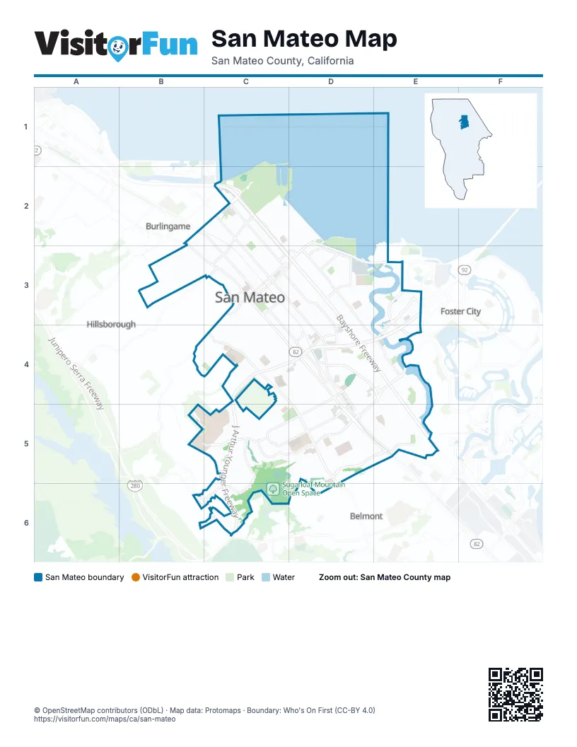
Street index of San Mateo
Each street on the sheet and the grid squares it crosses.
- Bayshore FreewayC2, C3, D3, D4, E4, E5
- J Arthur Younger FreewayE3, C4, D4, E4, C5, C6
- South El Camino RealC3, C4, D4, D5, E5
- J Hart Clinton DriveD2, D3, E3
- East 3rd AvenueC3, D3, E3
- North El Camino RealB2, B3, C3
- East 4th AvenueC3, D3
- West 3rd AvenueC3
- El Camino RealB2, E5
- West 4th AvenueC3
- Alameda de las PulgasC4, D4, D5, D6
- West Hillsdale BoulevardB5, C5, D5
- South Norfolk StreetD2, D3, D4, E4
- South Delaware StreetC3, D3, D4, D5
- Mariners Island BoulevardE3, E4
- Saratoga DriveD4, E4, E5
- East Hillsdale BoulevardE4, D5
- South Grant StreetC3, D3, D4
- Fashion Island BoulevardE3, D4, E4
- East Poplar AvenueC2, C3
- North San Mateo DriveC2, C3
- Kehoe AvenueD3, E3
- North Delaware StreetC2, C3
- 9th AvenueC3, D3
- 19th AvenueD4
- Peninsula AvenueC2
- Concar DriveD4
- Airport BoulevardC2
- Bridgepointe CircleE3
- East 28th AvenueD4
- Bridgepointe ParkwayE3
- Franklin Parkway WestD4, E4
- Crystal Springs RoadC3, B4
- Polhemus RoadB6, C6
- South San Mateo DriveC3
- Chess DriveE3
- East 25th AvenueD4
- Ralston AvenueC6
- 42nd AvenueD5, E5, D6
- 31st AvenueC5, D5
- Palm AvenueC3, C4, D4
- North Amphlett BoulevardC2, C3
- 2nd AvenueD2, C3, D3
- Pacific BoulevardD4, D5, E5
- South Amphlett BoulevardC3, D3, D4
- 28th AvenueD4, C5, D5
- Shoreview AvenueD3
- De Anza BoulevardC5, C6
- North Bayshore BoulevardC2
- North Humboldt StreetC2, C3
- South Humboldt StreetC3, D3
- Newbridge AvenueD3
- Glendora DriveC5
- Laurie Meadows DriveE5
- South Bayshore BoulevardC2, C3, D3
- Lindbergh StreetC2, D3
- East 31st AvenueD5
- Howard AvenueC2
- West Santa Inez AvenueC3
- South BoulevardD4
- Olympic AvenueE5
- Dumont StreetE5
- Rollins RoadC2
- Old County RoadE5
- Coyote Point DriveC2
- South Railroad AvenueC3, D3, D4
- Parrott DriveC3, B4, C4, C6
- Hacienda StreetD4, D5
- Monte Diablo AvenueC2, D2, C3
- Edison StreetD4, D5
- West Poplar AvenueB3, C3
- Clark DriveB3
- North Idaho StreetC2, C3
- Barneson AvenueC4
- South Claremont StreetC3, D3, D4
- Warren RoadB3
- Parkwood DriveC5, C6
- West 39th AvenueD5
- Fernwood StreetD5
- North Claremont StreetC2, C3
- Park PlaceD4, E4
- 29th AvenueC5, D5
- South B StreetC3, D3, D4
- 36th AvenueD5
- Los Prados StreetE4, E5
- Cypress AvenueC2, D2, C3
- Isabelle AvenueC4, D4, D5
- Edinburgh StreetC3, C4
- West 41st AvenueD5, E5
- 26th AvenueC4, D4, C5
- 30th AvenueC5, D5
- East Santa Inez AvenueC2, C3
- Maple StreetC3, C4
- Tilton AvenueC2, C3
- East 5th AvenueC3, D3
- 10th AvenueC3, D3
- 27th AvenueD4, C5, D5
- East Perimeter RoadB5, C5
- Roberta DriveD3, E3, D4
- Bermuda DriveD4
- 37th AvenueD5
- Hobart AvenueC4
- Occidental AvenueB3
- South Idaho StreetC3, D3
- Branson DriveE4, E5
- Edgewood RoadB3
- South Fremont StreetC3, D3
- West 20th AvenueC4, D4
- Campus DriveC5
- Flores StreetD4, D5
- West Bellevue AvenueB3, C3
- Vista del MarE4
- Seal Point ParkD2, D3
- Martin DriveE4, E5
- 24th AvenueC4, D4
- Virginia AvenueC3, C4
- Harvard RoadC3, C4
- Notre Dame AvenueC3, C4
- Highland AvenueB2, C3
- East 40th AvenueE5
- La Selva StreetE4, E5
- Kingridge DriveD5
- Birch AvenueD3
- Sylvan AvenueD5
- South Eldorado StreetC3, D3
- Shoreline DriveE3, E4
- Monterey StreetC5, D5
- Aragon BoulevardC3, C4
- East 39th AvenueE5
- North Ellsworth AvenueC2, C3
- Norton StreetD3
- Poinsettia AvenueE4, D5
- Avila RoadC4
- Seville WayC3, C4
- 22nd AvenueC4, D4
- 23rd AvenueC4, D4
- North Kingston StreetC2
- Nevada AvenueC4
- West 25th AvenueC4, D4
- Borel AvenueC4, D4
- East Bellevue AvenueC2, C3
- Ensenada WayC4, C5, D5
- Pasadena DriveE4, E5
- Castilian WayC3, C4
- Casanova DriveE4, E5
- 7th AvenueC3, D3
- North Eldorado StreetC2, C3
- State StreetC2, B3
- Hurlingham AvenueB3, C3
- Woodbridge CircleE5
- 43rd AvenueD5, E5
- Costa Rica AvenueB3
- West Perimeter RoadB5, C5
- Patricia AvenueD3
- Cottage Grove AvenueD3
- Lakewood CircleC6
- Shoal DriveE3
- Crescent AvenueB3
- Fathom DriveE3
- George AvenueE5
- Grand BoulevardC2, B3, C3
- CSM DriveB5, C5
- East 16th AvenueD3, D4
- Sunnybrae BoulevardD3
- Rosilie StreetE5
- Franklin ParkwayD4, D5
- West 40th AvenueD5
- North Grant StreetC2, C3
- North Fremont StreetC2, C3
- Armada WayE3
- Curtiss StreetD5, E5
- Mason LaneC5
- La Casa AvenueD5, D6
- Sonora DriveC4
- Coyote Point Park RoadC2
- Royal AvenueD3
- Laurelwood DriveC5, D5
- San Miguel AvenueD5, E5
- Cherrywood DriveC5, C6
- Yates WayD4, E4
- Lodi AvenueD3
- Fiesta DriveD4
- Ocean View AvenueD3
- Hemlock AvenueD3
- Dale AvenueD3
- West 38th AvenueD5
- North Railroad AvenueC3
- Beresford StreetD5, E5
- Fairfax AvenueC3, C4
- Georgetown AvenueC4
- Laurel AvenueC3
- Eisenhower StreetD3, D4
- Yew StreetC4
- Indian AvenueC2
- Orinda DriveE5
- Viewridge DriveD5
- Countryside DriveC5
- Wayne WayD4, E4
- Woodland DriveC4
- Waters Park CircleD4, E4
- Athletic Loop RoadC5
- Sunset TerraceC5
- Leslie StreetD4
- Ventura AvenueC5, D5
- Colegrove StreetD5
- Villa TerraceC2, C3
- North Quebec StreetC2, D2
- Dorchester RoadB3
- Lake StreetE3
- Pico AvenueC4, C5
- Hamlet StreetD3, D4
- Elm StreetC3
- Derby AvenueD4
- Mc Lellan AvenueE4, D5
- Greenfield AvenueD5
- Louise LaneD5
- Overland DriveC5
- Trollman AvenueC2
- Del Monte StreetC5, D5
- Holland StreetE4
- Huron AvenueC2
- Meadow View PlaceD3
- Baze RoadD4
- Sequoia AvenueC5
- Clearview WayC5
- Portola DriveD4, D5
- 12th AvenueD3, C4
- Rand StreetD3
- Prague StreetC2, D2
- 1st AvenueC3
- Otay AvenueD5, E5
- College Heights DriveC5
- Washington StreetD3, D4
- Dix StreetD3
- Folkstone AvenueD3
- Bettina AvenueD5, D6
- Fairmont DriveC6
- Casa de Campo WayE4
- South Ellsworth AvenueC3
- Cobb StreetD3
- Prospect RowB2, B3, C3
- Borden StreetD3
- Columbia DriveB4, C4
- Hayward AvenueC3
- Foothill DriveC4
- La Selva CircleE4
- Van Buren StreetD3
- Marina CourtE4
- Nadina StreetC4
- Oak StreetC4
- Rolling Hills AvenueD5
- Woodside WayC2
- Garfield StreetD4, D5
- Wilshire AvenueD5
- 11th AvenueC3, D3, C4
- West 5th AvenueC3
- 14th AvenueD3, C4
- Marina VistaE4
- Ottawa StreetC2, D2
- Murphy DriveC4
- Palos Verdes DriveC5
- Carlisle DriveD3
- Oregon AvenueC4
- Annapolis DriveD4
- York AvenueC2, D2
- Bovet RoadC4, D4
- 16th AvenueC4, D4
- Shasta DriveC5
- East Laurel Creek RoadD5, C6, D6
- Dakota AvenueD3
- Bromfield RoadB3
- Cedarwood DriveC5
- Sycamore AvenueB3
- North RoadE5
- Lago StreetE4
- Live Oak DriveC4, C5
- Maxine AvenueD3
- Bayridge WayC5
- 15th AvenueC4, D4
- Alhambra RoadC3, C4
- Baywood AvenueC3
- Camden AvenueD5
- 13th AvenueD3, C4
- Fallon AvenueD3
- Cuesta AvenueC4, C5
- Santa Clara WayE4, E5
- Spuraway DriveC4
- Detroit DriveD3
- 17th AvenueD4
- Windward WayE4
- Shafter StreetC4
- Tilia StreetC4
- Cupertino WayE5
- Wolfe DriveD3, D4
- Guildford AvenueD3
- Vailwood WayE5
- Vista del SolE4
- De Sabla RoadC3
- Nash DriveD3
- Ramona StreetC3
Things to do on the San Mateo map
Places on the map
- 101/92 Park And Ride
- Aragon High School
- Bay Area Storage
- Bay Meadows Park
- BayCenter
- Bayside Middle School
- Bayside/Joinville Park
- Beresford Park
- Borel Shopping Center
- College of San Mateo
- Coyote Point Beach
- Coyote Point Marina
- Crystal Springs Village
- de Anza Historical Park
- Dog Park
- Franklin Templeton
- George Hall Elementary School
- Hillsdale High School
- Hillsdale Shopping Center
- Joinville Park
- Junipero Serra High School
- Laurelwood Center
- Los Prados Park
- Marina Branch San Mateo Public Library
- Marina Plaza
- Martin Luther King Park
- Parkside Aquatic Park
- Parkside Elementary School
- Poplar Creek Golf Course
- Saint Johns Cemetery
- San Mateo Central Park
- San Mateo County Event Center
- San Mateo Medical Center
- Seal Point Park
- Seal Slough
- Sugarloaf Mountain Open Space
Next to San Mateo
© OpenStreetMap contributors, Open Database License, openstreetmap.org/copyright · Map data: Protomaps · Boundary: Who's On First (CC-BY 4.0); Quattroshapes (CC BY 2.0)















