

California map
Santa Paula map
About 31,786 people live here (Census Bureau, 2024 estimate). The sheet's index lists 300 streets; Santa Paula Freeway, Ojai Road and East Harvard Boulevard cross the most grid squares. Things to do inside the boundary: Museum of Ventura County Agriculture Museum and Sunburst Railbikes.
Open the map (PDF, US Letter)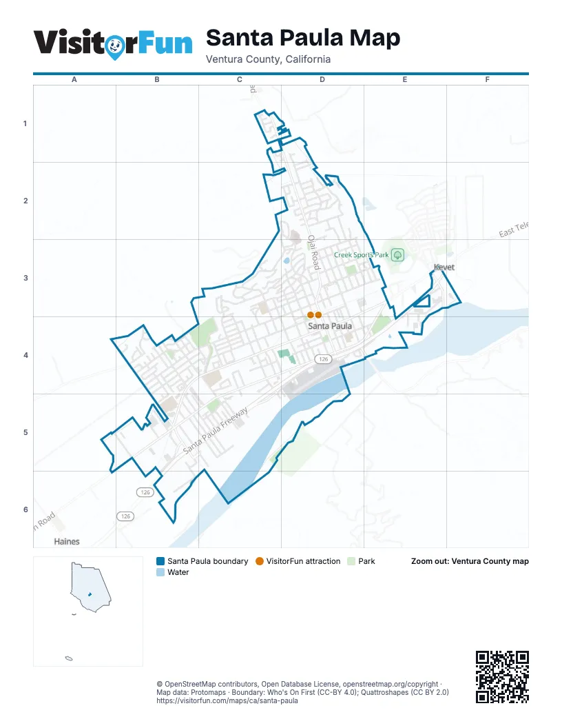
Street index of Santa Paula
Each street on the sheet and the grid squares it crosses.
- Santa Paula FreewayE3, C4, D4, E4, B5, C5, B6
- Ojai RoadC1, D1, D2, D3
- East Harvard BoulevardE3, C4, D4, E4
- North 10th StreetD2, D3, D4
- West Harvard BoulevardC4, B5, C5
- South Peck RoadB5
- South 10th StreetD4
- East Telegraph RoadE3
- West Telegraph RoadA5, B5, A6
- Faulkner RoadB5, B6
- South Hallock DriveE3
- East Main StreetD3, E3, C4, D4
- East Santa Maria StreetC4, D4, C5
- West Main StreetB4, C4, B5
- West Santa Maria StreetB5, C5
- North Peck RoadB4, B5
- South Palm AvenueC4, C5
- Acacia RoadB5, C5
- South 12th StreetD4, E4
- Acacia WayB5, C5
- East Santa Paula StreetD3, E3, C4
- East Ventura StreetC4, D4, E4
- West Santa Paula StreetB4, C4
- West Santa Barbara StreetB4, C4, B5
- East Santa Barbara StreetD3, C4, D4
- East Virginia TerraceC3, D3
- Monte Vista DriveC3, D3
- North 12th StreetD3, D4
- North Mill StreetD3, D4
- North 6th StreetC3, C4
- Loma Vista PlaceC3, D3
- Todd LaneB5, B6
- Laurie LaneB5, C5
- Richard RoadB4
- Cemetery RoadC4
- Lucada StreetB5, C5
- North 13th StreetD3
- Center LaneB4, C4
- Outer DriveC4, C5
- Bradley StreetC3, C4
- North 9th StreetD3, D4
- Mariposa DriveD1, D2
- East Orchard StreetD3
- South Steckel DriveC4, C5
- Cliff DriveD2
- Dickenson RoadC3, C4
- Saticoy StreetD3, E3
- Richmond RoadD2, D3
- East Pleasant StreetC3, D3, C4
- Cameron StreetB4
- Beckwith RoadA5, B5, B6
- North 8th StreetD3, D4
- Laurel RoadD2
- North Oak StreetD3, D4
- North Palm AvenueC3, C4
- Sycamore StreetD3
- Lemonwood DriveE3, E4
- Woodland DriveD2
- West Santa Cruz StreetB5, C5
- North 14th StreetD3, E3
- North 7th StreetC3, C4, D4
- Dartmouth RoadB5, C5
- Say RoadD2
- High StreetD3
- Grant Line StreetD2, E3
- View DriveC3
- Foothill RoadB4
- North Steckel DriveB4, C4
- Forest DriveD2
- Moultrie PlaceC4
- Guiberson StreetD2, D3, E3
- Teague DriveC3, D3
- Calpipe RoadB5, B6
- South 8th StreetD4
- Coronado CircleC2, D2
- South Olive StreetC4, D5
- North 11th StreetD3, D4
- Palm CourtC3, C4
- Blanchard AvenueC3, C4
- Yale StreetC4, D4
- South Ojai StreetD4
- Glenway StreetC3, D3
- Fern Oak DriveD2
- Cherry Hill RoadC1
- North Ojai StreetD3, D4
- Craig DriveC4, C5
- Mc Kevett RoadC3, D3
- Atmore DriveB4, C4
- North Olive StreetC4
- Ridgecrest DriveB4
- Eliot StreetC4
- Hillview Drive WestB5
- Wakeford AvenueC4
- Hillview Drive EastB5
- Pamela LaneB4
- Walden StreetB4, B5
- Citrus StreetD3
- South 4th StreetC4, D4
- Railroad AvenueD3, D4
- South 7th StreetD4
- South Mill StreetD4
- Encino PlaceD2, D3
- Dean DriveC4
- LincolnC5
- Sheppard RoadB5
- Santa Rosa LoopC5
- Hardison StreetB4
- Glade DriveC3
- West Santa Anna StreetC5
- South 11th StreetD4
- Howie CourtC3
- Park StreetD3
- Garcia StreetD3, D4, E4
- Dickenson DriveC3
- Manzanita DriveD2
- Dana DriveC3
- Bahia CircleB4
- Anacapa TerraceB4
- Santa Creg LoopC5
- McKevett HeightsC3, D3
- La Vuelta PlaceD3
- 5th StreetC3, C4
- Royal Oaks PlaceC2, D2
- Cornell DriveC5
- Felkins RoadB5
- Southwick StreetB4
- Terracina DriveD3
- Princeton StreetC5
- Warren AvenueC4
- South Oak StreetD4
- Vista Grande DriveC2, D2, D3
- Ernest DriveD2, D3
- Magnolia DriveD1, D2
- CoolidgeC5
- East Santa Anna StreetC4
- Elizabeth CourtB5, C5
- KennedyC5
- San Nicolas AvenueB4
- Montclair DriveC3
- RooseveltC5
- East Santa Clara StreetD4, E4
- South Calavo StreetB5
- Old Hallock DriveE3
- Bedford StreetD2, D3
- Manor Ridge RoadC3
- Peach DriveA5
- Fuchsia LaneD2
- Vernon WayC4, C5
- Hobbs CircleC3
- Venus AvenueB4
- Corporation StreetB5
- Maple StreetD2
- Poppy LaneD2
- Fillmore StreetB5
- Peralta DriveC5
- Sheffield StreetB4
- Vernon PlaceC4, C5
- EisenhowerC5
- Munger DriveB4
- NixonC5
- Birch StreetD1, D2
- Colgate StreetC5
- Quail CourtE3, E4
- California StreetD4
- Clubhouse DriveB5
- Los Robles DriveD2
- Stanford StreetD4
- Davis StreetD4
- New StreetD4
- North 5th StreetC4
- Mupu StreetC4
- West Pleasant StreetC4
- Orange WayA5, B5
- San Clemente StreetB4
- Oakdale PlaceD2
- Tangerine WayA5, B5
- Via del PradoB5
- Lime WayA5, B5
- Skyline DriveB4
- Cherry DriveA5, B5
- Rhame TerraceC4
- Pinehill LaneC3, C4
- Elm StreetB5
- Hawthorn StreetD2
- Ralph WayD2, D3
- Easy StreetC5
- Vista Pointe PlaceD3
- West Virginia TerraceC3, C4
- Leavens CourtB4
- Fremontia StreetD2
- South 5th StreetD4
- West Salas StreetB4
- North 4th StreetC4
- RedbudD2
- South 13th StreetE4
- Persimmon WayA5, B5
- Larmon LoopC4, C5
- Prieto StreetD3, E3
- Sonoma LaneC4
- San Juan StreetB4
- Stonegate RoadC1
- Steckley DriveC5
- San Miguel WayB4
- Brett WayD4
- Jacaranda DriveD2
- Mc Kevett Heights RoadC3, D3
- Lindsay LaneB5
- Tirre CourtC5
- Trent LaneB4
- Apricot WayA5, B5
- Roger RoadD2
- Walnut StreetD3
- Avocado WayA5
- Marin RoadC4
- North Salas StreetB4
- Santa Clara StreetD4
- Hudson WayD3, D4
- Marigold LaneD2
- Miller LaneD3, D4
- Green StreetD4
- Shasta DriveB4
- Valencia WayB5
- Plum WayA5
- Bruce DriveD2
- Greenwood DriveD2
- Holly RoadD2
- Eloisa StreetC5
- Sunset LaneD3, E3
- Channel WayC5
- Country View CourtA5, B5
- Yale CourtC4
- April LaneC1
- Casabella CourtC5
- Dale CourtC4
- Redwood LaneC3
- Sunny StreetC5
- Dove CourtE3, E4
- Via PacificaB5
- Via SolanaB5
- DogwoodD2
- Morrison LaneB4
- Pear DriveB5
- Larkspur StreetC1, D1
- March StreetC4
- Estriga CourtB4, C4
- Towns CourtB4
- June StreetD2
- King CourtB4
- Richmond CourtD3
- Monterey PlaceD3
- Santa Barbara StreetD3
- Lemon WayA5, B5
- Weston CourtC4
- Colton CourtC5
- Orange RoadA5, B5
- Pepper Tree LaneD3, E3
- Prairie LaneD3, E3
- Harvey DriveD2
- Arthur AvenueC4
- Grant StreetD2
- Montebello StreetD4
- Amber DriveC1, D1
- Corta StreetD4
- Corte LindaB5
- Cadway StreetD2
- Floyd DriveC5
- Honeywood CourtC1
- Thomas DriveC5
- Wendy LaneC3
- Happy StreetC5
- Via PasadaB5
- Gatewood LaneD1
- Hillside DriveD2
- Corte Mira FloresB5
- Valencia CourtB5
- AdamsC5
- Corte DescansoB5
- HooverC5
- JohnsonC5
- Corte la BrisaB5
- Corte GranadaB5
- RosewoodD2
- Ellfred CourtB4, B5
- North Gibbs StreetC5
- South Gibbs StreetC5
- Lassen DriveB4
- Peck PlaceB5
- Cedar StreetC1
- Vela CourtB4
- Beech DriveC1
- Elderberry CourtC1
- Willow LaneC4
- Lilac LaneC3
- 11th StreetD4
- Aspen CourtD2
- Rincon CourtB4
- Staben CourtC4
- Bedford CourtD2, D3
- Westeria LaneC5
- Cabrillo CourtB4
Things to do on the Santa Paula map
Places on the map
- Bank of America
- Blanchard Community Library
- Blanchard Elementary School
- Boys & Girls Club of Santa Clara Valley
- Bunnin Chevrolet of Santa Paula
- California Oil Museum
- Carl's Jr.
- Chapala Mexican Restaurant
- Charles M Teague Park
- Chase
- Denny's
- El Brillante Market
- Fagan Barranca Park
- Gil's Food & Market
- Glen City Elementary School
- Grace Thille Elementary School
- Hampton Ranch Restaurant
- Harding Park
- Higher Vision
- Jack in the Box
- Jones Field
- Las Piedras Park
- McDonald's
- Mill Park
- O'Reilly Auto Parts
- Obregon Park
- Ocean Gateway Inn
- Ragatz Bicycle Shop
- Railroad Plaza Park
- Ray's R&R Market
- Reclamation Pond
- Royal Car Wash
- Sam Santa Paula Market
- Santa Cruz Plaza
- Santa Paula 7
- Santa Paula Airport
- Santa Paula Art Museum
- Santa Paula Cemetery
- Santa Paula City Hall
- The UPS Store
Next to Santa Paula
- Haines
- Kevet
- Prancer's Farm
© OpenStreetMap contributors, Open Database License, openstreetmap.org/copyright · Map data: Protomaps · Boundary: Who's On First (CC-BY 4.0); Quattroshapes (CC BY 2.0)















