

California map
Simi Valley map
About 125,778 people live here (Census Bureau, 2024 estimate). The sheet's index lists 300 streets; Ronald Reagan Freeway, East Los Angeles Avenue and Cochran Street cross the most grid squares. Things to do inside the boundary: Ronald Reagan Presidential Library & Museum and Visit Simi Valley.
Open the map (PDF, US Letter)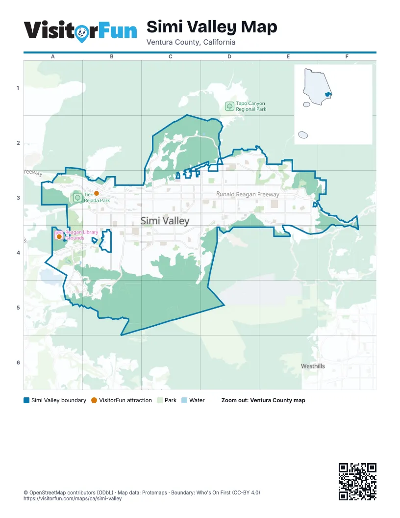
Street index of Simi Valley
Each street on the sheet and the grid squares it crosses.
- Ronald Reagan FreewayA3, B3, C3, D3, E3, F3
- East Los Angeles AvenueA3, B3, C3, D3, E3
- Madera RoadB3, A4, B4
- Tierra Rejada RoadA3, B3
- Kuehner DriveE3, E4
- Viewline DriveB3
- Santa Susana Pass RoadF3, F4
- View Lane DriveB3
- Cochran StreetB3, C3, D3, E3
- Alamo StreetC3, D3, E3
- First StreetB3, B4
- Sequoia AvenueD3, C4, D4
- Erringer RoadC2, C3, C4
- Royal AvenueD3, B4, C4, D4
- Tapo Canyon RoadD2, D3, D4
- Wood Ranch ParkwayA4, B5
- Sycamore DriveC3, C4
- Yosemite AvenueE2, E3
- Fitzgerald RoadB4, C4
- Long Canyon RoadB4, B5
- Stearns StreetE3
- 1st StreetB3
- Lost Canyons DriveC2, D2
- Tapo StreetD2, D3
- Cottonwood DriveD2, E2
- West Los Angeles AvenueA3, B3
- Simi Town Center WayB3, C3
- Walnut AvenueD2, D3
- Sinaloa RoadB3, B4
- Country Club DriveA4, B4
- Galena AvenueC3
- Presidio DriveD2, D3
- Arcane StreetB4, C4
- Mount Sinai DriveE3
- Heywood StreetC3
- Circle Knoll DriveA5, B5
- East Easy StreetB3
- Martha Morrison DriveA4, A5, B5
- Katherine StreetE3
- Patricia AvenueB3, C3
- Katherine RoadE4
- West Cochran StreetB3
- West Easy StreetB3
- Guardian StreetD3, D4
- Falcon StreetC3
- Rocky Peak Fire RoadF3
- Country Club Drive WestA4
- Country Club Drive EastB4
- Avenida SimiC3, D3
- Township AvenueC3, D3
- Lake Park DriveA4, B4
- Barnard StreetD3, E3
- Mellow LaneB4, C4
- Rambling RoadB4, C4
- Hidden Ranch DriveE3, E4
- Kadota StreetD3
- Elizondo AvenueC3, C4
- Presidential DriveA4
- Appleton RoadC4
- Stow StreetE3
- Talbert AvenueC4
- Azure Hills DriveB4, C4
- Texas AvenueD2, D3
- Adam RoadD3
- Valley Gate RoadB4
- Morley StreetC3
- Corto StreetC4, D4
- Dalhart AvenueD2, D3
- Hudspeth AvenueB4
- Canyon View DriveB5
- Evening Sky DriveE2
- Stonebrook StreetB4
- Lemon DriveD2, D3
- 4th StreetB3, B4
- White Bark LaneD4
- Corpus Christi AvenueD2, D3
- East Larch StreetC3
- Agnew StreetB3, C3
- Flanagan DriveE3
- Apricot RoadD3
- Sunnydale AvenueB4, C4
- Waco AvenueD2, D3
- Alexander StreetB3, C3
- Hilldale AvenueC3, D3
- Irvine RoadB4
- Meadowood ApartmentC3
- East Jefferson WayB3, C3
- Highland RoadB4
- Amarillo AvenueD2, D3
- Galveston AvenueD2, D3
- Barnes StreetC3, D3
- Austin AvenueD2, D3
- East Brower AvenueC3
- Indian Hills DriveE3
- Ahart StreetB3, C3
- Kieu Hoang WayE3, F3
- Alscot AvenueE3
- Rudolph DriveC4
- El Monte DriveB4
- Sutter AvenueB4, C4
- Gibson AvenueC4
- Legacy DriveC2, C3
- Westwood StreetD2, E2
- Angus AvenueD3
- Travis AvenueD2, D3
- Angela StreetC3, D3
- Medina AvenueC3, D3
- Aristotle StreetB3
- Watson AvenueC4
- North Justin AvenueC3
- Nonchalant DriveB4
- Rancho Coralles ApartmentA4
- Rocking Horse DriveC4
- Hasson Service RoadE3
- Reservoir DriveC3
- Longbranch RoadB4
- Graham StreetB3, C3
- National WayB3
- Eagle Flight DriveC2
- Big Springs AvenueD2, D3
- Deacon StreetC3, C4
- Paseo del SolD3
- Crosby AvenueC4
- Fletcher StreetC4
- Lee StreetC3
- Pride StreetB3, B4
- Sinaloa VillaB3
- Acapulco AvenueB3, B4
- Callahan AvenueC3
- Seneca PlaceE3
- Khkmy CircleF3
- Ditch RoadC2, D2, C3
- Leeds StreetD3, E3
- Covington AvenueC4
- Maricopa DriveE3
- Copley StreetC3, D3
- Tracy AvenueD3
- Church StreetC3, C4
- Stoneman StreetC3
- Racine StreetC3
- Whitcomb AvenueC4
- Olympic StreetC3, D3, D4
- Brentwood StreetC3, D3
- Nelda StreetE3
- Stargaze PlaceA3
- Kearney AvenueB4, C4
- Sheri DriveD2, D3
- Blackstock AvenueC3, C4
- Fig StreetD3
- Meander DriveB4, C4
- Hollister StreetC3, C4
- North Ardenwood AvenueE3, F3
- Crater StreetC3, C4
- Lions CircleA3
- Sycamore Grove StreetB5
- Belhaven AvenueE3
- Catlin StreetB4
- Fort Worth DriveD3
- East Bonita DriveB3
- Hubbard StreetB3, C3
- Ralston StreetD3
- Christine AvenueE3, E4
- High Meadow StreetA4, B4, B5
- Eileen StreetD3
- Legends DriveC2
- Bristol AvenueB4
- Haven AvenueC4
- Caldwell AvenueB3
- Brea Canyon RoadB3
- Melia StreetE3
- Stonegate VillasE3
- Sandalwood DriveE3, F3
- Waltham RoadB4
- Valley Fair StreetD3
- Bannister WayA5, B5
- Vanessa StreetD3
- Sapphire AvenueC3, D3
- Bluegrass StreetB4
- Bennett StreetB4
- Greenville DriveD2, D3
- Winifred StreetD3
- Oldstone PlaceB4
- North Bigelow AvenueC3
- Anderson StreetB3, C3
- North Deodora StreetC3, C4
- Industrial StreetD3
- Longbranch NobleB4
- Elmdale AvenueC3
- Arroyo Vista RoadD3
- Woodhaven StreetD3
- Springfield StreetD3
- Marvel AvenueC3
- Vineyard DriveB5
- Cordero AvenueC3
- Heather StreetC3
- Wisteria StreetC3
- Clover StreetC3
- East Chesterton StreetC3
- Fresh Meadows RoadA4
- Sitka AvenueD3, D4
- Rebecca StreetD3
- Saint Clair AvenueE3
- Alta StreetD3, E3
- Smith RoadE4, F4
- Keystone StreetE3
- Hempstead StreetD2
- Hamilton StreetB4, C4
- Wallace StreetB4, C4
- Golden Glen DriveA4
- Alpine StreetD3
- Innwood RoadA4
- Moreno DriveD3, D4
- Young Wolf DriveC2
- Placerita DriveE3
- 3rd StreetB3, B4
- Goldenwood CircleA4, B4
- Bridget AvenueC3
- Tuttle AvenueB4
- Shunk RoadE3
- Simi Village DriveB3
- Congressional RoadA4
- North Muirfield AvenueC4
- East Barnes StreetC3
- Enchanted WayB3
- Sebring StreetC3
- Coastal Oak DriveC4, D4
- Mountain Vista LaneC4
- Stanford DriveC4
- Hope StreetE3
- Madrone StreetC3
- Magnolia StreetC3
- Lupin StreetC3
- Darrah AvenueD3
- East Aurelia StreetE3
- Ish DriveD3
- Oak Haven AvenueE3
- Dusan StreetC4
- Delilah StreetD3
- Eve RoadD3
- Gardner StreetC4
- Larchmont StreetA4
- Arielle LaneC4
- Indian Point DriveE3
- Winterdew AvenueA3
- Bitternut CircleC3
- Balsamo AvenueB4
- Waldo AvenueC3
- Mayfair StreetB3, C3
- Rory LaneE3
- Ward AvenueB3
- Latham StreetC3
- Renee CourtC3
- Lindale AvenueC3
- Summertime AvenueA3
- Crazy Horse DriveE3
- North Goodard AvenueD3
- Twisted Oak DriveB5
- Rim of the Valley TrailD4
- Los Amigos AvenueB3, B4
- North Hietter AvenueD3
- Summit AvenueD2
- Country Club Drive StreetA4
- Roosevelt CourtA4
- Village ParkwayB3
- Leisure LaneB4
- Ysrella AvenueC3
- Indian Terrace DriveE3
- Brandon AvenueC4
- Vallejo AvenueC4
- Lysander AvenueB3
- Belinda StreetD3
- Carlotta StreetD3
- Deborah StreetD3
- Florence StreetD3
- Gertrude StreetD3
- Parker CourtC3
- Aspen StreetD4
- Wheatfield CircleD3
- Cutler StreetC4
- East Woodrow AvenueC3
- King Palm DriveC4, D4
- Laurel Fig DriveC4
- Willowbrook LaneB3, B4
- Lakota StreetC2
- Mohave DriveE3
- Morning Glory StreetC3
- Citronella StreetD3
- 2nd StreetB3, B4
- Cliffwood DriveA3
- Rockingham DriveE4
- East Malton AvenueE3
- Emeric AvenueB3
- Ridgegate LaneB3
- Helene StreetD3
- San Angelo AvenueD3
- Lathrop AvenueD2
- Rockdale AvenueE3
- Omega AvenueD3
- Donner AvenueC4
- North Woodrow AvenueC3
Things to do on the Simi Valley map
Places on the map
- Adventist Health Simi Valley
- alkali marsh
- Allied Studios
- Arroyo Simi Equestrian Center
- Assumption Cemetery
- Atherwood Elementary School
- Big Springs Elementary School
- Challenger Park
- Chumash Park
- Chumash Park Natural Preserve
- Corriganville Park
- Country Club Drive Street
- Coyote Hills Park
- Darrah Volunteer Park
- FedEx
- Happy Face Hill
- Hillside Middle School
- Hummingbird Nest Ranch
- Justin Early Learners Academy
- Katherine Elementary School
- Knolls Elementary School
- Lang Ranch - Montgomery Ranch Open Space
- Loop Trail
- Lost Canyons Golf Course
- Mount Sinai Memorial Parks and Mortuaries
- Mountain Gate Plaza
- Oak Park
- Old Susana Postal Express
- Old Windmill Park
- Park View Elementary School
- Rancho Simi RPD Open Space
- Reagan Library Grounds
- Santa Susana Town Center
- Simi At The Plaza
- Simi Hills Golf Course
- Simi Valley Town Center
- Sycamore Square
- Tierra Rejada Park
- Wood Ranch Golf Club
- Wood Ranch Open Space
Next to Simi Valley
- Westhills
© OpenStreetMap contributors, Open Database License, openstreetmap.org/copyright · Map data: Protomaps · Boundary: Who's On First (CC-BY 4.0); Quattroshapes (CC BY 2.0)















