

California map
Ukiah map
About 16,067 people live here (Census Bureau, 2024 estimate). The sheet's index lists 270 streets; Redwood Highway, South State Street and North Bush Street cross the most grid squares. Things to do inside the boundary: Mendocino County Tourism Commission.
Open the map (PDF, US Letter)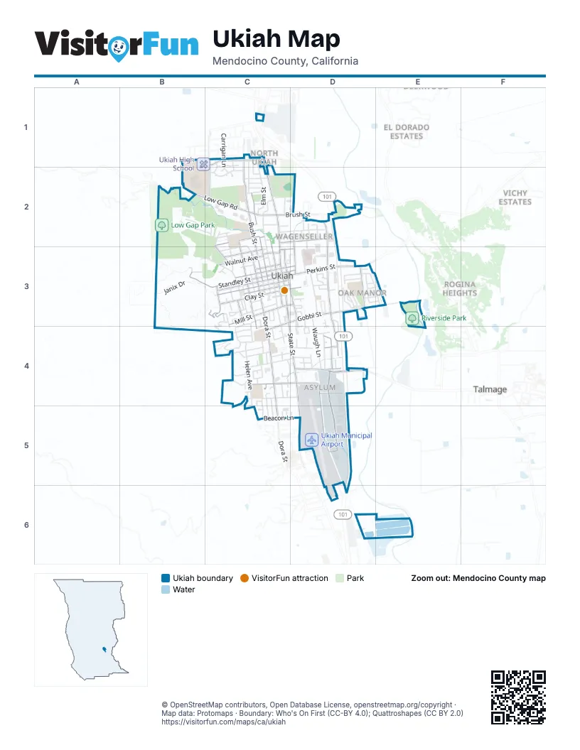
Street index of Ukiah
Each street on the sheet and the grid squares it crosses.
- Carrigan LaneC1, C2
- Despina DriveC1, C2
- Donner CourtC1
- Donner LaneC1
- Elm StreetC1, C2
- Empire DriveC1
- Ford RoadC1
- Homewood DriveC1, C2
- Incline CourtC1
- Incline DriveC1, C2
- Irvington DriveC1, C2
- Lockwood DriveC1, C2
- North Bush StreetC1, C2, C3
- North State StreetC1, C2, C3
- Dominican WayB2, C2
- Fairway AvenueB2
- Lost Treasure RoadB2
- Low Gap RoadB2, C2
- Maple AvenueB2, C2
- Valley View DriveB2
- Arlington DriveC2
- AzaleaC2
- Bricarelli DriveC2
- Brush StreetC2, D2
- Burlington DriveC2
- CamelliaC2
- Capps LaneC2
- Carleton DriveC2
- CedarC2
- Clara AvenueC2, D2
- Crystal Bay CourtC2
- Cypress AvenueC2
- Cypress-GroveC2, C3
- Cypress-MapleC2
- Dora AvenueC2, C3
- Dora-CypressC2, C3
- ElmC2
- Elm CourtC2
- Evans StreetC2
- Fairgrounds EntranceC2
- FirC2
- Ford StreetC2, D2
- Garrett DriveC2
- Gibson StreetC2
- Hazel AvenueC2, C3
- Jackson AvenueC2
- Live Oak AvenueC2, C3
- Live Oak DriveC2
- Magnolia StreetC2
- Mazzoni StreetC2
- North Oak StreetC2, C3
- North Pine StreetC2, C3
- North School StreetC2, C3
- North Spring StreetC2, C3
- Redwood Empire FairgroundsC2
- Ruddock AvenueC2
- Saint Francis AvenueC2
- Summit CourtC2
- Tahoe CourtC2
- Zephyr Cove CourtC2
- City Well RoadD2
- Hamilton StreetD2, D3
- Joseph StreetD2
- Mason StreetD2, D3
- Myron PlaceD2
- Myron StreetD2
- North Orchard AvenueD2, D3
- Orr StreetD2
- Orrs Creek BridgeD2
- Redwood HighwayD2, D3, D4, D5, D6
- Sidnie CourtD2
- Sidnie StreetD2
- Giorno AvenueB3
- Janix DriveB3, B4
- Park BoulevardB3, C3
- West Standley AvenueB3
- West Standley CourtB3, C3
- West Standley StreetB3, C3
- Barbara StreetC3
- Betty StreetC3, D4
- Calvert CourtC3
- Calvert DriveC3
- Carolyn StreetC3
- Clay PlaceC3
- Don Rones DriveC3
- East Church StreetC3
- East Clay StreetC3, D3
- East Gobbi StreetC3, D3, E3
- East Mill StreetC3, D3
- East Perkins StreetC3, D3
- East Smith StreetC3, D3
- East Standley StreetC3, D3
- East Stephenson StreetC3
- Eastlick StreetC3
- Echo WayC3
- Gardens AvenueC3, C4
- Grove AvenueC3
- Grove-DoraC3
- Highland CourtC3
- Highland DriveC3, C4
- Holden StreetC3
- Jones StreetC3
- Lookout DriveC3, C4
- Mae StreetC3
- Mary LaneC3
- May StreetC3
- McPeak StreetC3
- Mendocino DriveC3, C4
- Mill CourtC3
- Morris StreetC3
- Myszka PlaceC3
- North Barnes StreetC3
- North Dora StreetC3
- North Highland AvenueC3
- North Hope StreetC3
- North Hortense StreetC3
- North Main StreetC3
- Norton StreetC3, D3
- Oak Park AvenueC3
- Park CourtC3
- Park PlaceC3
- Pomolita DriveC3, C4
- Pomolita WayC3, C4
- Scott StreetC3
- Seminary AvenueC3
- Snuffin StreetC3
- South Barnes StreetC3
- South Bush StreetC3
- South Dora StreetC3, C4, C5
- South Highland AvenueC3
- South Hope StreetC3
- South Hortense StreetC3
- South Main StreetC3, D3
- South Oak StreetC3, C4
- South Pine StreetC3
- South School StreetC3
- South Spring StreetC3, C4
- South State StreetC3, C4, D4, D5
- Terrace DriveC3
- Thompson StreetC3
- Todd RoadC3
- Walnut AvenueC3
- Walnut-GroveC3
- West Church StreetC3
- West Clay StreetC3
- West Gobbi StreetC3, C4
- West Henry StreetC3
- West Mill StreetC3
- West Perkins StreetC3
- West Scott StreetC3
- West Smith StreetC3
- West Stephenson StreetC3
- Willow AvenueC3
- Willow-WalnutC3
- Babcock LaneD3, D4
- Cindee DriveD3, D4
- Clay StreetD3
- Cleveland LaneD3
- Club House DriveD3
- Courthouse BoulevardD3
- El Rio CourtD3
- El Rio StreetD3
- Freeway DriveD3
- Hospital DriveD3
- Kings CourtD3
- Leslie StreetD3
- Main CircleD3
- Manor DriveD3
- Marshall StreetD3
- Maya WayD3, E3
- Mohawk DriveD3, E3
- Oak Manor CourtD3
- Oak Manor DriveD3
- Olga PlaceD3
- Orchard PlazaD3
- Peach StreetD3
- Plum DriveD3
- Plum StreetD3
- Pomeroy AvenueD3
- Pomo DriveD3
- Pomo WayD3, E3
- Porzio LaneD3, D4
- Robinson LaneD3
- South Orchard AvenueD3, D4
- Stella DriveD3
- Vichy Springs RoadD3
- Village CircleD3, D4
- Warren DriveD3
- Washo DriveD3, E3
- Waugh LaneD3, D4
- Wiyat DriveD3
- Yaqui DriveD3, E3
- Yosemite DriveD3
- Maiden VoyageE3
- Albright PlaceC4
- Alice AvenueC4
- Banker BoulevardC4
- Baywood CourtC4
- Biltmore StreetC4
- Cochrane AvenueC4
- Court StreetC4
- Creekside CourtC4
- Cresta DriveC4
- Dalton DriveC4
- Doolan Canyon DriveC4
- Doolan DriveC4
- Fleetwood DriveC4, D4
- Foothill CourtC4
- Freitas AvenueC4, D4
- Helen AvenueC4
- Hillcrest AvenueC4
- Hillview AvenueC4
- Hurlie DriveC4
- Laurel AvenueC4, C5
- Louise CourtC4
- Luce AvenueC4, D4
- Marwen DriveC4
- Mendocino PlaceC4
- Modern Mobile Home ParkC4
- Mulberry StreetC4
- Nehoc CourtC4
- Nokomis DriveC4
- Observatory AvenueC4, D4
- Redwood AvenueC4
- Rose AvenueC4, C5
- San Jacinta DriveC4
- South AvenueC4
- South StreetC4
- Wabash AvenueC4, D4
- Washington AvenueC4, D4
- Washington CourtC4
- Yokayo CourtC4
- Yokayo DriveC4, C5
- Airport Park BoulevardD4, D5
- Airport RoadD4, D5
- Apple AvenueD4
- Caldwell Frontage RoadD4
- Cherry CourtD4
- Cherry StreetD4
- Commerce DriveD4
- Cooper LaneD4
- Cunningham StreetD4
- Deborah CourtD4
- Elks WayD4
- Hastings AvenueD4
- Hastings RoadD4
- Henderson LaneD4
- Lewis LaneD4
- Lorraine StreetD4
- Marlene StreetD4
- Max Hartley WayD4, D5
- Perry StreetD4
- Quality InnD4
- Regency InnD4
- Rupe StreetD4
- Talmage Frontage RoadD4
- Talmage RoadD4
- Taqueria JalosD4
- Thomas StreetD4
- Beacon LaneC5, D5
- Berkeley WayC5
- Canyon View CourtC5
- Ranee LaneC5
- Beacon WayD5
- Jefferson LaneD5
- Townsend LaneD5
- Bethal LaneD6
- Norgard LaneD6
- Plant RoadD6
- Pomo LaneD6
Places on the map
- Accelerated Achievement Academy
- Adventist Health Ukiah Valley
- Affordable Automotive
- AG Unlimited
- Americas Best Value Inn
- Amphitheatre
- Anton Stadium
- Comfort Inn & Suites Ukiah
- Costco
- Frank Zeek Elementary School
- Giorno Park
- Heart & Vascular: Adventist Health
- Holiday Inn
- Low Gap Disc Golf
- Low Gap Park
- Mendocino County Law Library
- Mendocino County Library
- Nokomis Elementary School
- Oak Manor Elementary School
- Orr Creek
- Palace Hotel
- Park Falls Plaza
- Pear Tree Center
- Pomolita Field
- Pomolita Middle School
- Redwood Business Park of Ukiah
- Riverside Park
- Russian River Cemetery
- Safeway
- Todd Grove Park
- Twelfth District Fairgrounds
- Ukiah Civic Center
- Ukiah High School
- Ukiah Municipal Airport
- Ukiah Orchard Shopping Center
- Ukiah Post Office
- Ukiah Sports Complex
- Ukiah Valley Golf Course
- Walmart
- Yokayo Elementary School
Next to Ukiah
- Alexander Estates
- El Dorado Estates
- North Ukiah
- Presswood
- Rogina Heights
- Talmage
- Vichy Estates
© OpenStreetMap contributors, Open Database License, openstreetmap.org/copyright · Map data: Protomaps · Boundary: Who's On First (CC-BY 4.0); Quattroshapes (CC BY 2.0)















