

California map
Mendocino County map
About 89,175 people live here (Census Bureau, 2024 estimate). The sheet's index lists 300 streets; Redwood Highway, Shoreline Highway and Main Street cross the most grid squares. Things to do inside the boundary: Skunk Train, Anderson Valley and Confusion Hill.
Open the map (PDF, US Letter)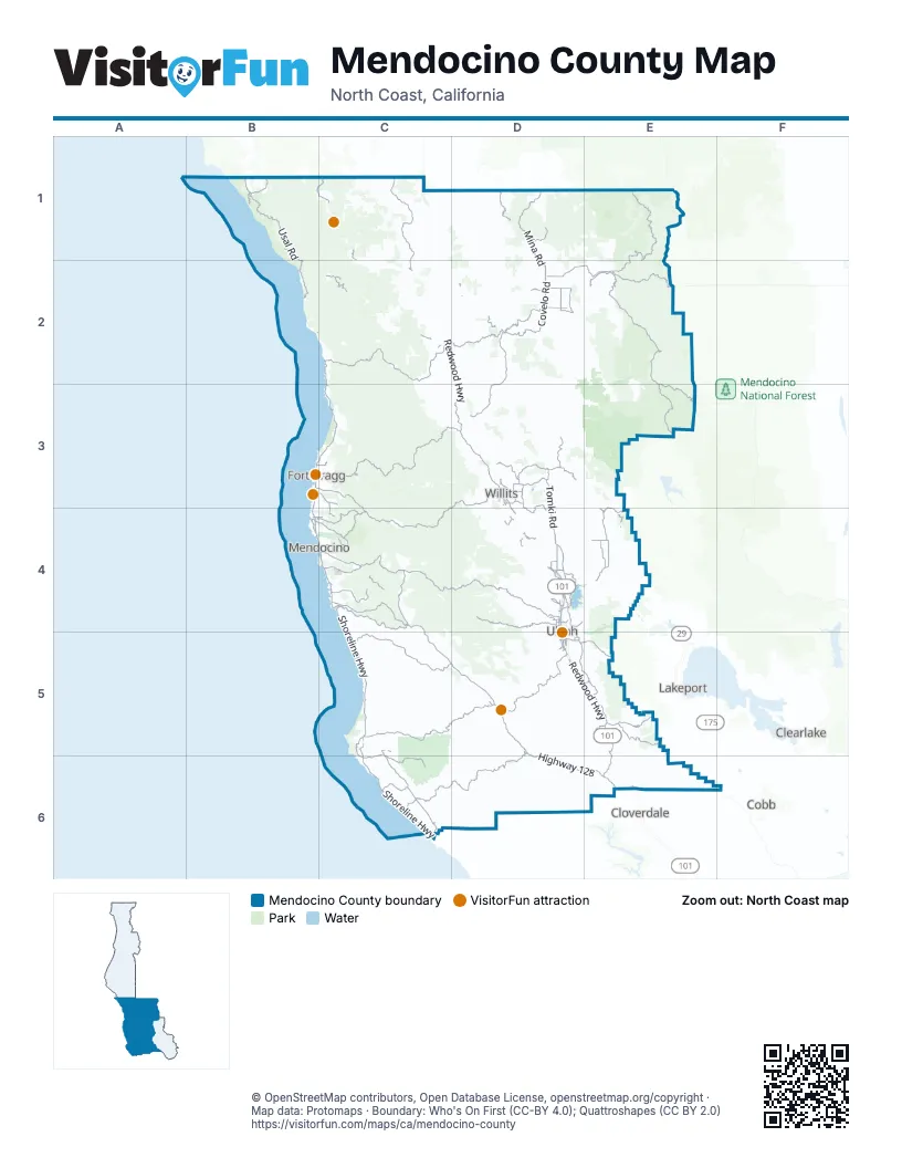
Maps inside Mendocino County
1 map inside, from the street map of Mendocino County down.
Street index of Mendocino County
Each street on the sheet and the grid squares it crosses.
- Redwood HighwayB1, C1, C2, D2, D3, D4, D5, E5, E6
- Daniel Broeske Memorial HighwayD4
- Orrs Creek BridgeD4
- Shoreline HighwayC2, B3, C3, B4, C4, C5, C6
- Highway 128C4, C5, D5, D6, E6
- Fort Bragg-Willits RoadB3, C3, D3, C4, D4
- Willits BypassD3, D4
- Fort Bragg RoadD3
- Main StreetD2, B4, C4, E4, E5, C6
- South Main StreetB3, D3, D5
- North Main StreetB3, C3, D3, D4, D5
- School StreetD2, D3, C4, C6
- Shoreline Highway - Highway 1C4
- Coast HighwayC6
- California State Route 1B2
- Covelo RoadD2, D3
- Branscomb RoadC2
- Mountain View RoadC5, D5
- Comptche Ukiah RoadC4
- Mendocino Pass RoadD2, E2
- Boonville RoadE2, D5
- Orr Springs RoadC4, D4
- Philo Greenwood RoadC5
- North State StreetD4, D5
- Eureka Hill RoadC5, C6
- Eel River RoadE3, E4
- West RoadC4, D4, E4
- Flynn Creek RoadC4
- East RoadD4, E4
- Iversen RoadC6
- Old Stage RoadC6
- Caspar Little Lake RoadB4, C4
- Hopland GradeE5
- Ten Mile RoadC6
- Lakeport-Hopland RoadE5
- Simpson LaneB3, C3
- Potter Valley RoadE4
- South State StreetD5
- Vichy Springs RoadD4
- Cutoff RoadE4
- Central AvenueD3, D4
- Talmage RoadD5
- Riverside DriveC5, E5, C6
- Ten Mile Cut Off RoadC6
- School WayC1, D4
- East Gobbi StreetD5
- Lansing StreetB4, C4
- Old State HighwayE4, C6
- East Perkins StreetD4, D5
- River RoadE4, E5
- West Lake Mendocino DriveD4
- Moore StreetD4
- Off-Road State Highway 20 CircleD4
- Ron Ledford Memorial BridgeD5
- Hopland RoadE5
- Pillsbury-Indian Dick RoadE1, E2, E3
- Fort Bragg-Sherwood RoadC3, D3
- Fish Rock RoadD5, C6, D6
- Usal RoadB1, B2
- Bell Springs RoadC1, C2
- Sherwood RoadD3
- Mina RoadD1, D2
- Hearst Willits RoadD3
- Low Gap RoadD4
- Old River RoadD5, E5
- Navarro Ridge RoadC4
- Tomki RoadD3, D4
- Little Lake RoadD2, C4
- Albion Ridge RoadC4
- Ridgewood RoadD3, D4
- Eastside RoadC2, D3
- Mountain House RoadE5, E6
- Old Toll RoadE5
- Dos Rios RoadC2, D2
- Poonkinny RoadD2
- Mill Creek RoadC2, D5, E5
- Caspar Orchard RoadB4, C4
- Low Gap-Bald Mountain RoadE2, E3
- Bald Mountain RoadD1
- Briceland RoadB1
- Little River Airport RoadC4
- Poonkinney RoadD2
- Adobe Creek RoadE5, E6
- Airport RoadD2, B3, C3, D5
- Hill RoadD2
- Reynolds HighwayD3
- State Route 271B1, C1
- Road AD4, E5
- Canyon RoadD3
- Hulls Valley RoadD1
- Parducci RoadD4
- Foster Mountain RoadD3
- Road BD3, D4
- East LaneD2, C4
- Laytonville Dos Rios RoadD2
- Point Cabrillo DriveB4
- East Side Calpella RoadD4
- Dobie LaneD2
- Fairbanks RoadD2
- Windy Hollow RoadC5, C6
- Uva DriveD4
- Lake Ridge RoadD4
- East Hill RoadD3
- Redemeyer RoadD4
- Center Valley RoadD3
- Mitchell Creek DriveC3, C4
- Burke Hill RoadD5
- South Dora StreetD5
- Paskenta-Mendocino Pass RoadE2
- Lake Mendocino DriveD4
- Lovers LaneD4
- Marina DriveD4
- Highway 271C1
- Laughlin WayD4
- Airport Park BoulevardD5
- North Bush StreetD4, D5
- East Oak StreetB3, C3, D3
- Buckridge RoadC5
- Sanford Ranch RoadD5
- Valley RoadC1, D3
- Ford RoadD4
- Eastside Calpella RoadD4
- West Standley StreetD4, D5
- Fircrest DriveD5
- Fern Creek RoadB4, C4
- East Commercial StreetD3
- Watson RoadD4, D5
- Baechtel RoadD3
- South Orchard AvenueD4, D5
- Drive-Thru Tree RoadC1
- North Pine StreetD4, D5
- Despina DriveD4
- West Church StreetD5
- West Clay StreetD5
- West Perkins StreetD5
- MinaD1
- West Mill StreetD5
- South Highland AvenueD5
- Knob Hill RoadD5
- Empire DriveD4
- Washington AvenueD5
- Geysers RoadE6
- North Orchard AvenueD4
- Little Lake StreetB4, C4
- Brush StreetD4
- Tollini LaneD4
- Willis AvenueC2
- Moonrise DriveC6
- Blosser LaneD3
- Clara AvenueD4
- West Smith StreetD4, D5
- South Spring StreetD5
- North Spring StreetD4, D5
- Meadowbrook DriveD3, D5
- Walnut AvenueD4
- Oak Manor DriveD4, D5
- Cypress AvenueD4
- Oak Court RoadD5
- Grove AvenueD4
- North School StreetD4, D5
- Lorraine StreetD5
- Mason StreetD4
- West Stephenson StreetD5
- East Valley StreetD3
- Harwood RoadC2, D2
- North Dora StreetD4, D5
- South School StreetD5
- North Lovers LaneD4
- Church StreetD2, C4, C6
- West Henry StreetD4
- McPeak StreetD5
- Caspar StreetB4
- OverlookD4
- Marlene StreetD5
- West Gobbi StreetD5
- Commerce DriveD5
- Live Oak AvenueD4
- Hastings AvenueD5
- Bray RoadD3
- Millview RoadD4
- East Clay StreetD5
- Talmage Frontage RoadD5
- Feed Lot LaneD4
- Highland Springs RoadE5
- Norton StreetD4
- East Smith StreetD4
- East Standley StreetD4
- Kuki RoadD4
- Scott StreetD4
- Burke Hill OverpassD5
- West Scott StreetD4
- East Mill StreetD5
- East Church StreetD5
- East Stephenson StreetD5
- North Highland AvenueD5
- Briceland-Thorn RoadB1
- Burke Hill DriveD5
- Masonite Industrial RoadC4, D4, D5
- Eden Valley Ranch RoadD2, D3
- Woodman Creek RoadC2, D2
- Little Valley Haul RoadC3
- Red Mountain RoadC1
- Island Mountain RoadC1, D1
- Three Chop RoadC3, D3, C4
- Reeves Canyon RoadD4
- Spyrock RoadC1, D1, C2
- Ramsey Ridge RoadC3
- Lundblade Ranch RoadC1, D1
- Hayworth Creek RoadC3
- Blands Cove RoadE1, E2
- Simmerly RoadC2, D2
- Black Bart TrailD4, E4
- Sloan RoadD2, D3
- Hammerhorn Lake RoadE1
- Main Ranch RoadD4
- Irmulco RoadC3, D3
- Elkhorn RoadD6
- M&M RoadB1, B2, C2
- Ridgeway HighwayE3
- Forest Route 17N25E4
- Pine Ridge RoadD4, D5
- Yorkville Ranch RoadD5, D6
- Mid Mountain RoadE4
- Etsel Ridge RoadE2
- Riley Ridge RoadC3
- Redwood Creek RoadC3, D3, D4
- Mariposa Creek RoadD4
- McNab Ranch RoadD5, E5
- Pine Mountain RoadE6
- County Road 110D5, E5
- Nash Mill RoadC5, D5
- Gibson LaneD4, E4, D5
- Westside RoadC2
- Cameron RoadC4, C5
- Pacific Heights DriveC2
- Chamberlain Ridge RoadC3, C4
- Combs RoadC1
- Feliz Creek RoadD5, E5
- Wilderness Lodge RoadC2
- Georgia-Pacific Haul RoadB3, C3
- Valley DriveC2
- North Branch RoadD6
- Hill Valley RoadD1
- Crispin RoadC5
- Shimmins Ridge RoadD3
- Helms RoadD3
- Pine AvenueE4
- Walker Lake RoadD4
- Stivers RoadD2
- Mendo Rock RoadE4, E5
- Main Chamberlain RoadC3, C4
- Erickson Ridge RoadE3
- Primrose DriveD3
- Pratt RanchE5
- Muir Mill RoadD3, D4
- Little Dann Creek RoadC1, C2
- String Creek RoadD3
- Timber RoadC3, D3
- Spring Valley RoadE4
- Zeni Ridge RoadC6, D6
- Willits Watershed RoadD4
- Oat Gap RoadE3, E4
- Indian Springs RoadC3, C4
- Williams Ranch RoadD4
- Appian WayC4
- Leech Lake RoadE1
- Rickard Ranch RoadD5, D6
- Woodman Peak RoadC2, D2
- Peachland RoadD5
- Bakers Creek RoadD4
- Docker Hill RoadC4
- Scenic DriveD3, D4
- Roseman Creek RoadC6
- Kenny Creek RoadC2
- Blackhawk DriveD4
- Signal Ridge RoadC5
- Monahan Creek RoadD6
- Dunham RoadD2
- Ridge RoadD3, D5
- Northspur RoadC3
- Arnette DriveC1
- Robinson Creek RoadD5
- West Chamberlain RoadC3, C4
- Nokomis RoadE5
- Butler Ranch RoadD5
- Center Ridge RoadC3, C4
- Holmes Ranch RoadC5
- Blue Lake RoadD3
- Anderson Valley WayD5
- Four Mile RoadD3
- University RoadE5
- Upper RoadC3
- Find Yer WayD4
- Heart Arrow TrailD4
- Cemetery LaneD2, D3
- Powerhouse RoadE4
- De Haven Creek RoadC2
- Railroad Gulch RoadC4
- Forest Route 20N01E4
- Ruddick Cunningham RoadD5
Things to do on the Mendocino County map
Places on the map
- Albion
- Albion River
- Anchor Bay
- Big River
- Bonterra
- Boonville
- Brooktrails
- Bushay Campground
- CAL Fire Mendicino Unit
- California Coastal National Monument
- Calpella
- Camp Navarro
- Caspar
- Caspar Headlands State Reserve
- City of Ten Thousand Buddhas
- Cleone
- Comptche
- Covelo
- Cow Mountain Management Area
- Double Cone Rock State Marine Conservation Area
- Eden Valley Wilderness Study Area
- Elkhorn Ridge Wilderness
- Fort Bragg
- Fort Bragg Airport
- Four Corners
- Goldeneye Winery
- Gut Opening
- Jackson Demonstration State Forest
- Lake Mendocino Recreation Area
- MacKerricher State Park
- Manchester State Park
- Mendocino Headlands State Park
- Navarro River Redwoods State Park
- Sanhedrin Wilderness
- Sinkyone State Wilderness
- Sinkyone Wilderness State Park
- South Fork Eel River Wilderness
- Ukiah Municipal Airport
- Van Damme State Park
- Yuki Wilderness
Next to Mendocino County
- Clearlake map
- Cloverdale
- Cobb
- Lakeport
© OpenStreetMap contributors, Open Database License, openstreetmap.org/copyright · Map data: Protomaps · Boundary: Who's On First (CC-BY 4.0); Quattroshapes (CC BY 2.0)















