

California map
Vista map
About 99,322 people live here (Census Bureau, 2024 estimate). The sheet's index lists 300 streets; Ronald Packard Parkway, Sunset Drive and South Melrose Drive cross the most grid squares. Also on it: Shadowridge Country Club, Brengle Terrace Park and Buena Vista Park Pond and Open Space.
Open the map (PDF, US Letter)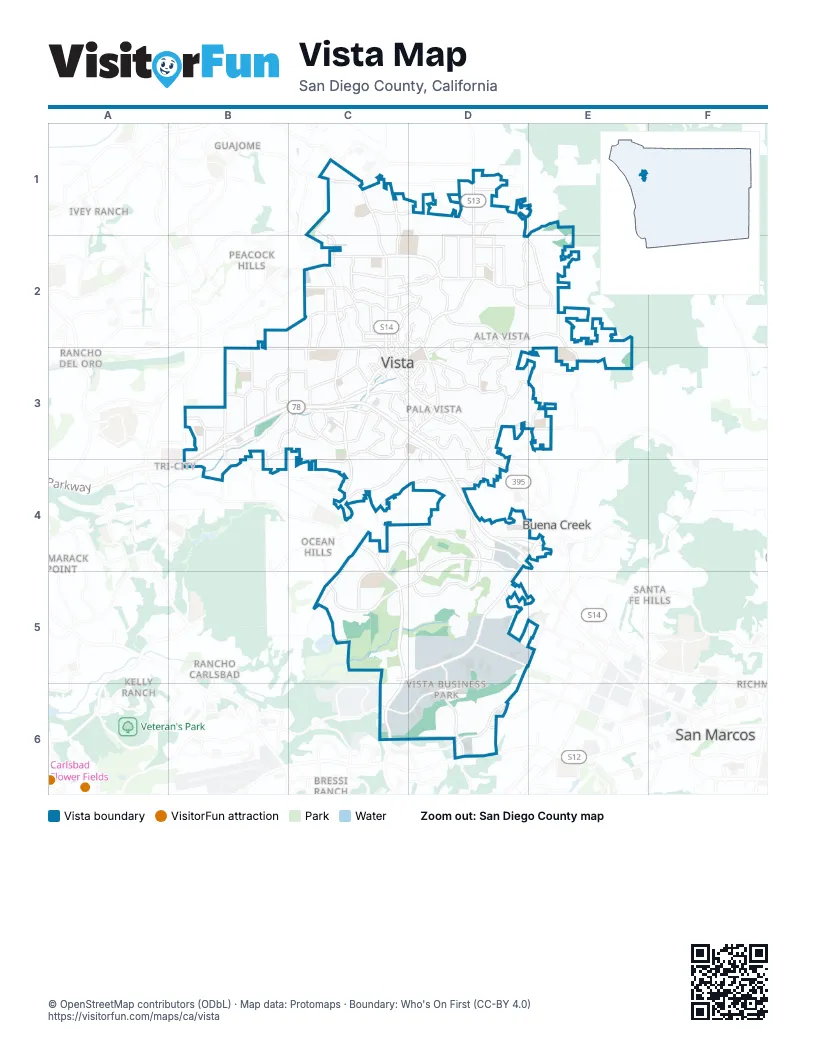
Street index of Vista
Each street on the sheet and the grid squares it crosses.
- Ronald Packard ParkwayB3, C3, D3, B4, D4, E4
- South Melrose DriveC3, C4, C5, C6
- Sycamore AvenueD4, E4, C5, D5
- North Santa Fe AvenueC1, C2, C3
- East Vista WayD1, D2
- South Santa Fe AvenueC3, D3, D4
- Vista Village DriveD2, C3, D3
- North Melrose DriveC2, C3
- West Bobier DriveC2
- West San Marcos BoulevardD6
- Melrose DriveC6
- Palomar Airport RoadD6
- Oceanside BoulevardC2
- Hacienda DriveB3, C3, B4
- Shadowridge DriveD4, C5, D5
- Alta Vista DriveD2, D3
- West Vista WayB3, C3, B4
- East Bobier DriveC2, D2
- Foothill DriveD2, E2, E3
- Olive AvenueC2, B3, C3
- Civic Center DriveD2, D3
- Mar Vista DriveD3, C4, D4
- Sunset DriveB3, C3, D3, B4, C4
- Vale Terrace DriveD2, E2
- Poinsettia AvenueD5, E5, D6
- Eucalyptus AvenueC3, D3
- Business Park DriveD5, D6
- Thibodo RoadD4
- Taylor StreetC1, D1
- Park Center DriveD5, C6, D6
- La Mirada DriveD5, E5
- Monte Vista DriveD3, E3
- Grapevine RoadB3
- Cypress DriveD3
- Townsite DriveC2, D2
- West Los Angeles DriveC2
- Main StreetC3, D3
- North AvenueC2
- North Emerald DriveB3
- South Emerald DriveB3, B4
- North DriveC2
- Emerald DriveB3
- Oleander AvenueD5
- Hibiscus WayD5
- Faraday DriveC6
- Plaza DriveB4
- Robelini DriveE4
- Warmlands AvenueD1, D2, E2
- Lupine Hills DriveD4, D5
- Phillips StreetD3, D4
- Oak DriveD2
- Lado De Loma DriveC3, D3
- North Citrus AvenueC2, C3
- Anza AvenueD1, D2
- Oceanview DriveC3, D3
- Live Oak RoadC4, D4, D5
- Vale View DriveC3
- Monte Mar RoadD2, E2
- Goodwin DriveC1, C2
- Anns WayC3
- Calle JulesD1, D2
- Maryland DriveC2, C3
- Beaumont DriveD3
- East Indian Rock RoadC2, D2
- Pomelo DriveB3, C3
- Arcadia AvenueD1, D2
- Bonair RoadD1, D2
- University DriveD4, E4
- Santa Clara DriveB3, C3
- West California AvenueC2
- Vista Grande DriveD1, E1
- Highland DriveC2, C3
- La Tortuga DriveC3
- Longhorn DriveC4, C5
- Durian StreetB3
- Avalon DriveD3
- Breeze Hill RoadC3
- Melrose WayC3, C4
- Cedar RoadB3
- Crest View RoadC3, D3, D4
- Hillside TerraceD2
- Independence WayD2
- Ravine RoadB3
- Tylee StreetB3, C3
- Rancho Vista RoadC3
- Matagual DriveC3
- Copper DriveC3
- Palomar PlaceD2
- Hill DriveB3
- Buena Vista DriveC4
- Plymouth DriveC3
- East DriveC2
- Pala Vista DriveD3
- Bobolink DriveC2
- West Indian Rock RoadC2
- Apollo DriveC2, D2
- Crescent DriveD3
- Avenue de Benito JuarezC2
- Sunrise DriveD3, E3
- Elm DriveD2, E2
- East Taylor StreetD1
- Bandini PlaceC3, D3
- East Vale View DriveC3
- Postal WayD3
- Plumosa AvenueD4, E4, D5
- Palm DriveC2, D2, C3, D3
- Sports Park WayC1, C2
- Cananea StreetC2, D2
- Jonathon StreetB3
- County ComplexC3
- Coventry RoadD3
- Watson WayD4, D5
- Cortez AvenueD2
- Westwood RoadB3
- Camino CortoC3
- Carriage CircleB3
- Valley DriveE3
- Guajome Lake RoadC1
- Prospect PlaceD3, D4
- East East DriveC2, D2
- West Connecticut AvenueC2
- York DriveE3
- Las Palmas DriveC3
- West DriveB3
- West BroadwayC3
- Heather DriveD2
- Nevada AvenueC2
- Sky Haven LaneB4
- Cantara LaneB3
- Marazon LaneB3, B4
- East BroadwayC3, D3
- Copper AvenueC3
- Knoll RoadC3
- Vale Terrace PlaceD2, D3
- North Indiana AvenueC3
- Melrose PlaceC2
- Providence DriveB3
- Terrace DriveD3
- Washington StreetC3
- Laguna DriveD1, D2
- Park AvenueC3, D3
- The CircleC2, C3
- Guajome StreetC3, D3
- Terracina WayC3
- Crestview RoadC3
- Camino PatriciaC3
- South Indiana AvenueC3
- Massachusetts AvenueC2
- South Citrus AvenueC3, D3
- Wave DriveC3
- East Connecticut AvenueC2
- East California AvenueC2
- Goetting WayC3
- Chaparral DriveD4
- Linda Vista DriveD6
- Michigan AvenueC3
- West Orange StreetC2
- Natal WayD3
- Alvarado TerraceC2, D2
- Lionshead AvenueD6
- Lobelia DriveE4
- Ridge RoadC4
- Santa Fe PlaceD3
- Avocado DriveD4
- Calle ChapultepecC2
- Osborne StreetC1
- Fall PlaceB3
- Barsby StreetD1
- Moran CourtB3
- Pomelo WayB3
- Green Oak RoadC5, D5
- Jim Porter ParkwayD2
- Paseo MargueritaC1
- Scott StreetD6
- San Clemente AvenueE3
- White Birch DriveC5
- Museum WayC1
- Adobe Estates DriveC1, C2
- Date StreetB3
- Brewley LaneD4
- Progress StreetD5
- Via ChristinaD2
- Tierra del CieloE1, E2
- Grand AvenueD5, E5
- Rudd RoadD3, E3
- Beverly DriveD2, E2
- Catalina AvenueE2
- San Luis Rey AvenueD1, D2
- Brookhaven PassC5, C6
- Huff StreetB3
- West Knapp DriveC1, C2
- Via Santa PauloB3, C3
- Spyglass CircleD4, D5
- Cielita Linda DriveB2, C2, B3
- Gail DriveC1, D1, D2
- Golfcrest PlaceD4, C5, D5
- Oak Glen DriveC4, D4
- Branding Iron DriveC4
- Drifting Circle DriveC4
- Harbor DriveC5, D5
- Countryside DriveC5
- Oak Ridge WayC6
- Tower DriveD3, D4
- Weston CircleC2
- Manor DriveC1, C2
- Sequoia CrestC5
- Opal RidgeC5, D5
- Columbus WayD4, D5
- Madrid DriveC4, D4
- Rolling Hills RoadD4
- Redwood CrestC5
- Brooktree LaneD4, D5
- Allesandro TrailE2
- Bluegrass RoadB3, C3
- Grandview RoadE2
- Specialty DriveD6
- Nob CircleD2
- Sleepy Hollow WayB3, B4
- Rose DriveC2
- Smith DriveC2, D2
- Meadowlake DriveD2
- Clear Crest CircleD2
- Hawley DriveD1
- Country Wood LaneD4
- Rosewood StreetC5
- Solara LaneD6
- Wellington LaneD4
- Courage StreetC5
- Caren RoadB3, C3
- Galaxy DriveB3
- Olympus Loop DriveC4, C5
- Amador AvenueB3, C3
- Via CentreB3, B4
- Lemon AvenueC2, D2
- Breeze Villa LaneC3
- Kings RoadE1, E2
- Waxwing DriveC2
- Eastbrook RoadC6
- Magellan LaneD5
- Antigua DriveC5
- Ruby DriveB3
- Willow Ridge DriveC5
- Marlin DriveD3
- Elm Ridge DriveC5
- Crystal Ridge WayC4, C5
- Skyline DriveE3
- Vineyard AvenueD4
- Queens WayE1, D2, E2
- Hilo WayD4
- Stratton DriveB2, C2
- Autumn LaneD1
- Promenade CircleB3
- Madera LaneD2
- Alta Mesa DriveD2, E2
- Nettleton RoadB3
- Tiger Tail RoadD3
- Cottage WayD4, D5
- Coronado PlaceD5
- Promontory Ridge WayC4, C5
- Parkwood AvenueD5, E5
- Engineer StreetD5
- Mesa Verde DriveD2, E2
- Manzanita CourtD4
- Mercantile StreetC3, D3
- Paseo RioB3, C3
- Crest DriveD3
- Pioneer AvenueD5
- Marsopa DriveC3, C4
- Bonita DriveC2, C3
- Longfellow RoadD4, D5
- Commerce WayD5
- Wandering RoadC3
- Dorsey WayC2
- Cherrywood StreetC5
- Edgehill RoadE2
- Dawson DriveC5, D5
- Distribution WayD5
- Verano WayD6
- Cerro LindoD2
- Camino Loma VerdeE2
- Activity DriveD6
- Calle SinaloaE2
- Rush AvenueC1, C2
- Portofino DriveD4
- Creekside LaneB3
- Prospect CircleD4
- Woodrail DriveC2
- Ferrara WayC3
- Parkview DriveD5
- Dogwood WayD5
- Berkeley WayD3
- Lantana WayD4, D5
- Delta LaneC3
- Lime PlaceC4
- Cordoba WayC4, D4
- Ithaca DriveC5
- Mountain Pass CircleC5
- Mistletoe StreetB3
- Keystone WayD6
- Ascot DriveC3
Places on the map
- 99 Cents Only Stores
- Albertsons
- ALDI
- ampm
- AutoZone
- Avis
- Boomers
- Breeze Hill
- Brengle Terrace Park
- Brengle Terrace Park Disc Golf Course
- Bub Williamson Park
- Buena Vista Park Ballfields
- Buena Vista Park Pond and Open Space
- Civic Center Park
- Costco
- Coxey Hill
- CubeSmart
- Foothill Oak Elementary School
- Grapevine Elementary School
- Guajome Park Academy
- Lowe's
- Monte Vista Elementary School
- North County Square
- Olive Elementary School
- Rancho Buena Vista High School
- Rancho Minerva Middle School
- Shadowridge Country Club
- Sleepy Hollow Way
- South Buena Vista Park
- The Pavilion Shopping Center
- The UPS Store
- Thibodo Park
- Vista Adult School
- Vista Detention Facility
- Vista High School
- Vista Magnet Middle School
- Vista Post Office
- Vista Sports Park
- Vista Tennis Club
- Vista Village Shopping Center
Next to Vista
- Bressi Ranch
- Buena Creek
- Calavera Hills
- Discovery Hills
- Guajome
- Ivey Ranch
- Kelly Ranch
- La Mirada map
- Ocean Hills
- Peacock Hills
- Rancho Carlsbad
- Rancho del Oro
- Richmar
- San Marcos map
- Santa Fe Hills
- Tamarack Point
- Tri-City
© OpenStreetMap contributors, Open Database License, openstreetmap.org/copyright · Map data: Protomaps · Boundary: Who's On First (CC-BY 4.0); Quattroshapes (CC BY 2.0)















