

Colorado map
Erie map
About 38,594 people live here (Census Bureau, 2024 estimate). The sheet's index lists 300 streets; Erie Parkway, East County Line Road and County Road 7 cross the most grid squares. Also on it: Coal Creek Open Space, Colliers Hill and Colorado National Golf Club.
Open the map (PDF, US Letter)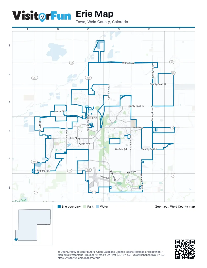
Street index of Erie
Each street on the sheet and the grid squares it crosses.
- Dwight D. Eisenhower HighwayF4
- Erie ParkwayB4, C4, D4, E4, F4
- Highway 52C2, D2, E2
- Arapahoe RoadA5, B5, C5
- State Highway 7C6
- East Baseline Road / Highway 7C6
- East Baseline Road / State Highway 7C6
- East County Line RoadC2, C3, C4, C5, C6
- County Road 7E2, E3, E4, E5
- County Road 5D2, D3, D4, D5
- Vista ParkwayC5, D5, D6
- County Road 10D3, E3, F3
- North 119th StreetB3, B4, B5
- Colliers BoulevardD3, D4
- County Road 3D2, D3
- Summit BoulevardD4, F4
- Aggregate BoulevardE2
- Colliers ParkwayD4
- Flatiron Meadows BoulevardB4, B5
- Mountain View BoulevardD6
- Austin AvenueB4, C4, C5
- County Road 6D5, E5
- Bonanza DriveD4, D5, D6
- Horizon BoulevardD3, D4
- Airport DriveC6
- North 111th StreetB5
- County Road 12E2, F2
- Jasper RoadB3, C4
- Sheridan ParkwayE5, E6
- North 109th StreetA4
- County Road 10 1/2C3, D3
- Meller StreetC4, C5
- Briggs StreetC3, C4
- Skyline DriveD6, E6
- Telleen AvenueB4, C4
- Mason StreetC4, C5
- County Road 1 1/2C3, D3
- Cheesman StreetC3
- Bonnell AvenueC5
- Maxwell AvenueC4
- Peach AvenueD4, E4
- County Road 4D5, E5
- Ridge View DriveD6, E6
- Glacier DriveD4
- Sunset DriveD6
- Jay RoadC3
- Power StreetC4
- Fairway Pointe DriveD6
- Powers StreetC4
- Waterford StreetE4
- Kenosha RoadC3
- Rue de TrustD3
- Pikes Peak ParkwayE2
- West 169th AvenueE6
- Meadow BoulevardE2
- Alpine DriveD5, E5, D6, E6
- Meadow View ParkwayB4
- Village Vista DriveD6, E6
- Cessna DriveC5, C6, D6
- Garfield RoadD5
- Hickory DriveD5, D6
- Lombardi StreetC3
- Graham CircleC4, C5
- Flora View DriveD3
- Gold Hill DriveD3
- Chestnut AvenueD4, E4
- Marfell StreetB5
- Westerly BoulevardE4
- Tynan DriveB4, C4
- Pinecliff DriveD3, D4
- Grenville CircleC5
- Meadow Sweet LaneB4
- Highlands CircleD4
- Front Range RoadB5
- Banner CircleC3
- Baxter Farm LaneB4
- Kattell StreetC3, C4
- Piper DriveC6, D6
- Green Mountain DriveD3
- Northridge DriveC3
- Pierce StreetC3, C4
- Holbrook StreetC3, C4
- Blue Sky CircleD6
- Baker LaneC3
- Carlson AvenueB3, C3
- Serene DriveC5, D5
- Pope DriveB4, B5
- Commander DriveC5, D5
- Quest DriveC5
- West Ridge CircleD3, D4
- Sandstone CircleB5
- Eichorn DriveC4, C5
- Indian Peaks DriveD4
- Hughs DriveB5
- Limestone DriveB4, B5
- Northview DriveC3
- Compass ParkwayC5
- Lodgepole DriveD6
- Montgomery DriveD4
- High StreetC3, C4
- Morningside DriveD4, D5
- Washburn StreetC3
- Evans StreetC3
- Delechant DriveC3
- Harvest Point DriveB4
- Balcolm StreetC4
- Moffat StreetC4
- Mathews CircleC4
- Brennan CircleB4
- McGregor CircleC4
- Fletcher DriveC3
- North Parkdale CircleC5, D5
- Allen AvenueC3
- Lawson AvenueD5
- Quarry CircleD3
- Carbonate LaneB4, B5
- Orion CircleD4
- Painted Horse WayD4
- Lehigh CircleD4
- Liberty StreetD4
- Marlowe DriveC3, D3
- Maccullen DriveB5
- Brennan StreetB4
- Acadia CircleD4
- Dinosaur DriveB4, B5
- Commander CircleC5, D5
- County Road 3 1/4D2
- C. W. Bixler BoulevardC3
- Dogwood DriveE6
- Walters DriveB4
- Longs Peak DriveD4
- Ironwood CircleD6
- South Parkdale CircleC5, D5
- Dawn AvenueD4
- Ambrose StreetC4
- Pioneer PlaceB5
- Flatiron CircleB5
- Highlands DriveD4
- West Interstate Highway 25 Frontage RoadF4
- Sunrise DriveD4
- Mircos StreetC4, C5
- Eva Peak DriveD3
- Jarvis DriveC4
- Gilpin CircleC5
- Madison DriveB4, B5
- Hickory AvenueD4, E4
- Marlowe Circle WestC2, C3
- Eagle CircleD6
- Marquette DriveC5
- Sunset WayD6
- Alpine Ridge StreetD3
- Main StreetC3, C4
- Bear Peak RoadD3
- Gallegos CircleC4
- Compass CircleC5
- Maplewood DriveB4
- Reliance DriveC5, D5
- Starlight CircleD4
- McAfee CircleD4
- Morgan Circle SouthC3
- Wilson CircleB4
- Boulder Peak AvenueD3, D4
- Koss StreetC4, C5
- Dogwood CircleE6
- Leyner DriveB4, C4
- Rocky Ridge CircleB5
- Petras StreetC4, C5
- Southard StreetB5
- Hoffman DriveC4
- Pikes View DriveD3, D4
- Marlowe Circle EastC2, C3
- Horizon AvenueD4
- Daily DriveB4, C4
- Wells StreetC4
- Equinox CircleD4
- Holeman DriveB5
- Meagan WayD2, D3
- Montclair AvenueC3, D3
- Bain DriveB4, C4
- Weston CircleB5, C5
- Ascent Trail CircleD3
- Equinox DriveD4
- Pinon CircleE6
- Fossil Bed CircleB4
- Weston DriveC5
- Morgan DriveC2, C3
- Homestead ParkwayB5
- Jackson DriveC4
- Zodo AvenueC4, C5
- Crestview LaneD5
- Mourning Dove AvenueB4, C4
- Polaris CircleD4
- Sundance CircleB4
- Pinnacle BoulevardC4
- Audubon Peak DriveD3
- Highlands BoulevardD4
- Billington DriveA5
- Fountain CircleB5
- Woodward StreetB5
- Powell StreetB5
- Homestead RoadB5
- Monares LaneD4
- Orion AvenueD4
- Sundance LaneB4, B5
- Wisteria DriveE6
- Dakota LaneB4, B5
- Primrose LaneD5, D6
- Stockton DriveC4
- Washington StreetD4, E4
- Stewart WayC4
- Stevens CircleA5, B5
- Nova CourtD4
- Apex Rise StreetD3, D4
- Columbine WayD5
- Greening AvenueC3
- Wheat Berry DriveB4
- Ridge View CircleD6, E6
- Tundra CircleE5
- Hawthorne AvenueD4, E4
- Prince CircleB5
- Poppy View LaneD4
- Mitchell WayC4
- Maxwell CircleC4
- Auburn DriveD4
- Commons DriveD6
- Nonaham LaneC3
- Odell DriveB5
- Windemere LaneD6
- Dusk PlaceD4
- Saint John StreetC3
- Carr StreetC4
- Anderson StreetC4
- Holly DriveE6
- Stanley DriveB4, C4
- Nelson StreetC5
- Raindance PlaceD4
- Skyhook StreetC4
- Apex StreetC4
- Lyons LaneB5
- Indian Paintbrush WayE5, E6
- Vale WayD6
- Perry StreetC4
- Lasnik StreetC4, C5
- Smoky Hills LaneB4
- Highview DriveD4
- Split Rock DriveD3
- Drake AvenueC5
- Sun Up CircleD4
- Village CircleC3
- Metcalf DriveD3
- Catalpa PlaceD5, D6
- Jacques WayC5, D5
- Pinon DriveD6, E6
- Driver LaneD5, D6
- Sugarloaf LaneD4
- Conrad DriveC4
- Irwin PlaceB4
- Sumner WayC4
- Taurus DriveD4
- Woodson DriveC4
- Morgan Circle NorthC3
- Brimble DriveC5
- Ridge View CourtE6
- Sanders CircleC4
- Cabot DriveC5
- Wright DriveC5
- Betts CircleB5
- Nighthawk StreetC4
- Heritage PlaceD6
- Leo DriveD3, D4
- Walker StreetB5
- Ash CircleD4, E4
- Azalea WayE6
- Carbonate CircleB5
- Clark DriveB4, C4
- Larkspur DriveD4
- Cartier PlaceC5
- Lawley DriveC4
- Cathedral Peak DrD4
- Chestnut CircleB4
- Hauck StreetB5
- Sunshine CircleD4
- Cherokee CourtD6
- Shuttleworth DriveC4, C5
- Kanemoto LaneC3
- Pear Lake WayD4
- Compass DriveC5
- Otega CourtC5
- Altona WayD4
- Summit Rise DriveD3
- Claystone CircleB5
- Palmer LaneB4, C4
- Espinoza StreetC4
- Saddle DriveC4
- Smith CircleD4
- Lilac CircleE6
- Gordon DriveB4
- Sawtooth PlaceD4
- Clayton WayC5
- Parade StreetE4
Places on the map
- 7-Eleven
- Arapahoe Ridge Park
- Autawash @ Vista Ridge
- Birdhouse
- Black Rock Elementary
- Coal Creek Disc Golf Course
- Coal Creek Open Space
- Colliers Hill
- Colliers Hill (cont'd)
- Colorado National Golf Club
- Columbine Mine Park
- Crescent Park
- Denver Regional Landfill
- Erie Commons
- Erie Community Park
- Erie High School
- Erie Highlands
- Erie Lake
- Erie Medical Campus
- Erie Middle School
- Erie Municipal Airport
- Erie SingletrackTrails at Sunset Open Space
- Front Range Landfill
- Future Red Tail Ranch
- Grandview Open Space
- Lehigh Park
- Longs Peak Park
- Meadowlark School
- Mount Pleasant Cemetery
- Nine Mile
- Reliance Park
- The Ballpark at Erie
- The Boneyard
- The UPS Store
- Thomas Reservoir
- Tri-County Self Storage
- Vista Pointe Open Space
- Vista Ridge Marketplace
- Vista Ridge Open Space
- Water Treatment Path
© OpenStreetMap contributors, Open Database License, openstreetmap.org/copyright · Map data: Protomaps · Boundary: Who's On First (CC-BY 4.0); Quattroshapes (CC BY 2.0)















