

Colorado map
Denver & Cities of the Rockies map
The sheet's index lists 28 highways; I-25, I-70 and US 85 cross the most grid squares. Things to do inside the boundary: 16th Street, Ameristar Casino Resort Spa Black Hawk and Ball Arena. Also on it: Arvada, Aspen Park and Aurora.
Open the map (PDF, US Letter)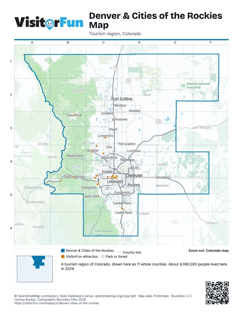
Highway index of Denver & Cities of the Rockies
Each highway on the sheet and the grid squares it crosses.
- I-25C1, C2, C3, C4, C5, C6, D5, D6
- I-70A5, B4, B5, C4, C5, D4, E4, E5
- I-76C4, D3, D4, E3
- I-225C5, D4, D5
- I-270C4, D4
- US 6C4, C5
- US 34B2, B3, C2, C3, D3, E3
- US 36B3, C3, C4
- US 40C5
- US 85C4, C5, D1, D2, D3, D4, D5
- US 87C1, C4
- US 285B5, C5
- US 287B1, C1, C2, C3, C4
- CO 2C4
- CO 7C4
- CO 14C2
- CO 58C4
- CO 66C3
- CO 83D5, D6
- CO 86D5, D6
- CO 88C5, D5
- CO 93C4
- CO 119C3, C4
- CO 121C4
- CO 157C4
- CO 257C2, D2, D3
- CO 392C2
- CO 470C5, D5
Things to do on the Denver & Cities of the Rockies map
- 16th Street
- Ameristar Casino Resort Spa Black Hawk
- Ball Arena
- Buffalo Bill Museum and Grave
- Casa Bonita
- Celestial Seasonings Tea Tour
- Chautauqua Park & the Flatirons
- Cherry Creek Shopping Center
- Clear Creek Rafting Company
- Colorado Adventure Center
- Colorado State Capitol
- Coors Brewery Tour
- Coors Field
- Denver Art Museum
- Denver Botanic Gardens
- Denver Charter Fishing
- Denver Mint
- Denver Museum of Nature & Science
- Denver Zoo Conservation Alliance
- Dinosaur Ridge
- Elitch Gardens
- Empower Field at Mile High
- FlatIron Crossing
- Georgetown Loop Railroad
- Larimer Square
- Longmont Museum
- Meow Wolf Denver: Convergence Station
- Mighty Argo Cable Car
- Molly Brown House Museum
- Monarch Casino Resort Spa Black Hawk
- Outlets At Castle Rock
- Park Meadows
- Pearl Street Mall
- Red Rocks Park & Amphitheatre
- Rocky Mountain National Park
- Southlands
- Southwest Plaza
- The Stanley Hotel
- Town Center at Aurora
- Union Station Denver
- Zinn Cycles
Places on the map
- Arvada
- Aspen Park
- Aurora
- Boulder
- Broomfield
- Castle Pines
- Castle Rock
- Centennial
- Denver
- Erie
- Estes Park
- Evergreen
- Fort Collins
- Fort Lupton
- Greeley
- Idaho Springs
- Johnstown
- Lakewood
- Lochbuie
- Longmont
- Loveland
- Mead
- Nederland
- Strasburg
- Thornton
- Windsor
Next to Denver & Cities of the Rockies
- Pikes Peak Wonders map
- Pioneering Plains map
- Rockies Playground map
- The Great West map
- Northwest Nebraska
- Southeast Wyoming
© OpenStreetMap contributors, Open Database License, openstreetmap.org/copyright · Map data: Protomaps · Boundary: U.S. Census Bureau, Cartographic Boundary Files 2024