

Colorado map
Federal Heights map
About 13,971 people live here (Census Bureau, 2024 estimate). The sheet's index lists 159 streets; West 101st Place, Pecos Street and Clay Street cross the most grid squares. Also on it: Carmenisch Park, Water World and Carstens Park.
Open the map (PDF, US Letter)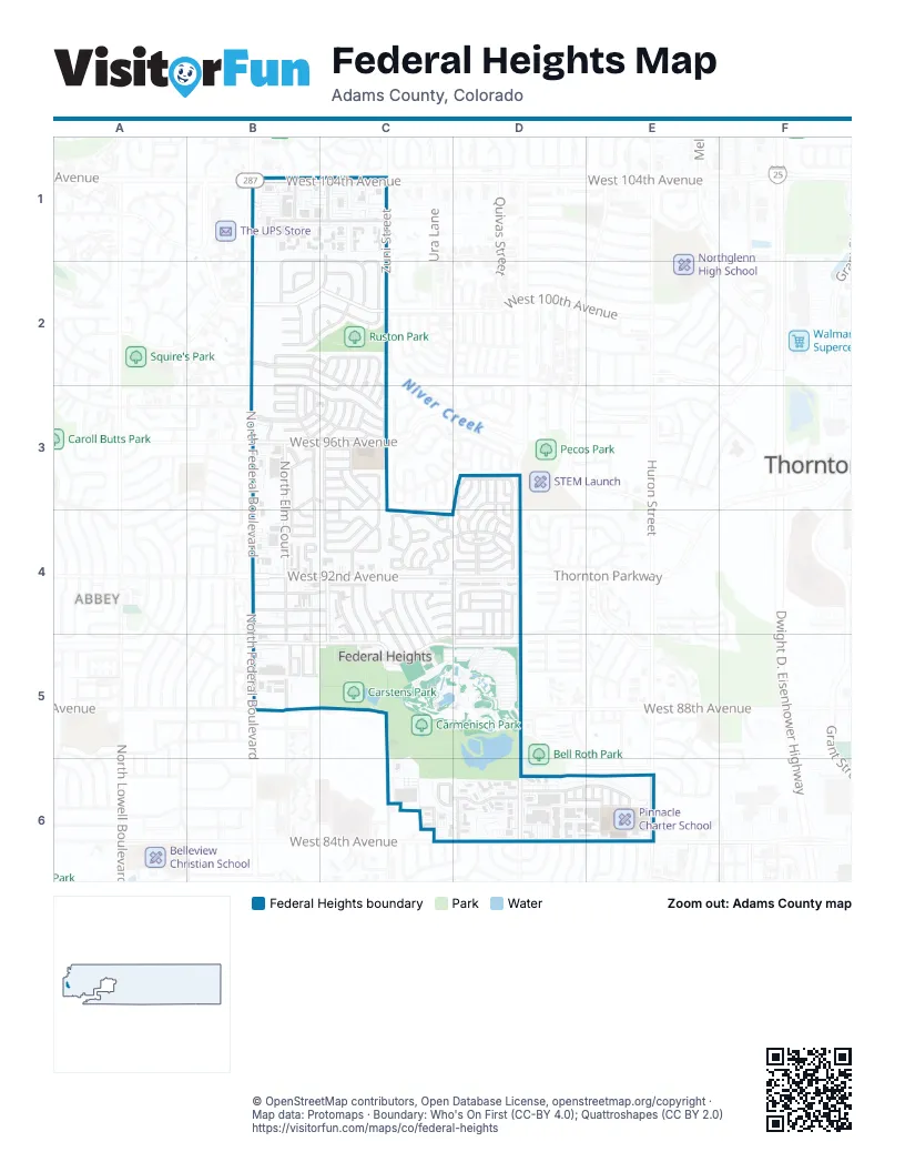
Street index of Federal Heights
Each street on the sheet and the grid squares it crosses.
- Eliot StreetB1, B2
- Elm CourtB1
- West 100th DriveB1, B2
- West 101st PlaceB1, C1, B2, C2
- West 102nd AvenueB1
- West 103rd AvenueB1, C1
- West 104th AvenueB1, C1
- Alcott StreetC1, C2
- Bryant StreetC1, C2
- Clay StreetC1, C2, B5
- North Clay StreetC1, B4, B5
- Zuni StreetC1, C2, C3
- Birch StreetB2, C2
- Canary StreetB2, B3
- Chestnut StreetB2, C2, C3
- Decatur StreetB2
- Eliot CircleB2
- Elm StreetB2, C2, C3
- Hawk StreetB2, B3, C3
- Oak StreetB2
- Pine StreetB2, C2, C3
- West 100th AvenueB2, C2
- West 98th CircleB2
- West 98th DriveB2, C2
- West 99th CircleB2
- West 99th PlaceB2, C2
- Ash StreetC2
- Aspen StreetC2
- Beach StreetC2
- Beech StreetC2
- Bryant CourtC2
- Cedar StreetC2, C3
- Cherry StreetC2, C3
- Clay CourtC2, C3, C4
- Fir StreetC2, C3
- West 100th PlaceC2
- West 101st AvenueC2
- Alder StreetB3
- Basswood StreetB3, C3
- Blue Jay StreetB3, C3
- Cardinal StreetB3
- Decatur CourtB3, B4
- Dove StreetB3
- Elm CircleB3, B4
- Falcon StreetB3
- Gull StreetB3
- Kimberly DriveB3
- North Elm CourtB3, B4, B5
- North Federal BoulevardB3, B4, B5
- Oriole StreetB3, C3
- Warbler StreetB3, C3
- West 94th AvenueB3, C3, B4
- West 94th DriveB3, B4, C4
- West 96th AvenueB3, C3
- West 96th LaneB3
- West Cascade DriveB3
- Alcott Circle NorthC3
- Bryant DriveC3
- Clay DriveC3
- Decatur WayC3, C4
- Elderberry StreetC3
- Lark StreetC3
- North Bryant DriveC3, C4
- Peacock StreetC3
- Pheasant StreetC3
- Tern StreetC3
- West 94th PlaceC3
- West 95th AvenueC3
- West 95th DriveC3
- West 95th PlaceC3
- West 96th DriveC3
- Wren StreetC3
- Holiday BendD3, D4
- Holiday CourtD3
- Holiday LaneD3
- Holiday LoopD3, D4
- Holiday PlaceD3
- Holiday RoadD3, D4
- Holiday RunD3
- Holiday SquareD3, D4
- Pecos StreetD3, D4, D5, D6
- Federal BoulevardB4
- West 90th PlaceB4, C4
- West 91st AvenueB4, C4
- West 91st PlaceB4, C4, D4
- West 92nd AvenueB4, C4, D4
- West 93rd AvenueB4, C4
- West 93rd PlaceB4, C4
- Alcott Circle SouthC4
- Holiday CircleC4
- Holiday CornerC4
- Holiday CrescentC4
- Holiday GardensC4
- Holiday GlenC4
- Holiday HeightsC4
- Holiday MallC4
- Holiday ParkwayC4, D4
- Holiday VistaC4
- North Camenish StreetC4, C5
- North Fayette StreetC4, C5
- North Fontaine StreetC4, C5
- North Madeline StreetC4, C5
- North Mandel StreetC4, C5
- North Orleans StreetC4, C5
- North Rampart StreetC4, C5
- North Royal StreetC4, C5
- West 91st DriveC4
- West 93rd DriveC4
- West 94th LaneC4
- West Germain StreetC4, D4
- West Moselle CourtC4
- West Moselle StreetC4, D4
- West Orleans LaneC4
- West Tulane StreetC4, D4
- Hillcrest DriveD4, D5
- Holiday BoulevardD4
- Holiday DriveD4
- Holiday PassD4
- Holiday TerraceD4
- Holiday TrailD4
- Holiday ValeD4
- Holiday ViewD4
- Holiday WayD4
- Lakewood DriveD4, D5
- Lamplighter DriveD4
- Mountain View DriveD4, D5
- North Tejon StreetD4, D5, C6
- Norwood DriveD4
- Pikes Peak DriveD4
- Ponderosa DriveD4
- Rolling Hills DriveD4, D5
- Sky Haven DriveD4
- Thornton ParkwayD4
- Valley Vista CircleD4, D5
- North Decatur StreetB5
- North Parkside ParkwayB5
- West 88th AvenueB5, D5
- West 89th AvenueB5
- West 90th AvenueB5, C5, D5
- North Zuni StreetC5, C6
- Dresden StreetD5
- Milky WayD5
- North Tejon WayC6
- North Umatilla StreetC6
- West 85th AvenueC6, D6, E6
- West 86th AvenueC6
- Aspen Meadows CircleD6
- North Lipan CourtD6
- North Lipan StreetD6
- North Mariposa StreetD6
- North Stacy DriveD6
- West 84th PlaceD6, E6
- Huron StreetE6
- Leo LaneE6
- North Inca CourtE6
- North Jason CourtE6
- North Jason StreetE6
- North Kalamath CourtE6
- North Kalamath StreetE6
Places on the map
- Aaron's
- Absolute Liquor Mart
- Advance Auto Parts
- Alpine Nissan
- AutoZone
- Carmenisch Park
- Carstens Park
- Cinch Factory Store
- CubeSmart
- Dollar General
- Eagles Lodge
- Exxon
- Family Dollar
- Federal Heights Elementary School
- Federal Heights Fire Department
- Federal Heights Town Hall
- Federal Plaza
- Firestone
- Hilltop Gardens
- Holiday Plaza
- King Soopers
- La Poblanita
- Larry H. Miller Ram Truck Center 104th
- level up tattoo co
- Little Bear Pond
- LivWell Dispensary
- McDonald's
- Minnow Creek
- O'Reilly Auto Parts
- Ocean Express Car Wash
- Pinnacle Charter School
- Platinum 84
- Ruston Park
- Safeway
- Sam's Warehouse Liquors
- SkyDiamond
- Sonic
- The Plaza of Federal Heights
- Thrive Church
- Water World
Next to Federal Heights
- Abbey
- Hillcrest
- Thornton map
© OpenStreetMap contributors, Open Database License, openstreetmap.org/copyright · Map data: Protomaps · Boundary: Who's On First (CC-BY 4.0); Quattroshapes (CC BY 2.0)















