

Colorado map
Montezuma County map
About 26,841 people live here (Census Bureau, 2024 estimate). The sheet's index lists 300 streets; Railroad Avenue, Mancos Canyon Road and Ismay Trading Post Road / County Road G cross the most grid squares. Things to do inside the boundary: Cliff Palace, Books and Mesa Verde Stables.
Open the map (PDF, US Letter)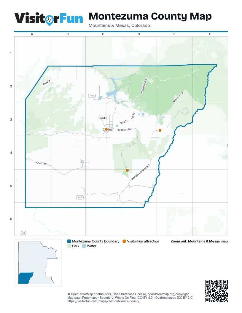
Street index of Montezuma County
Each street on the sheet and the grid squares it crosses.
- Railroad AvenueF1, C2, D2, C3, E3
- East Mancos RoadC3, D3
- Colorado StreetC2
- North BroadwayC3
- South BroadwayC3
- East Main StreetC3
- North Dolores RoadC3
- US 160E3
- West Main StreetC3
- US 491B6
- North Main StreetE3
- North Pinon DriveC3
- West U.S. Highway 160E3
- Mancos Canyon RoadD4, B5, C5, D5
- Ismay Trading Post Road / County Road GA3, B3, C3, C4
- Mesa Verde 1D3, D4
- Johnson Canyon RoadD5
- County Road 16B1, B2
- North Mildred RoadC3
- Alamosa RoadC3
- Mesa Verde Entrance RoadD4
- East Mike Wash RoadB4, C4
- East Empire StreetC3
- Dry Creek RoadB4, C4
- East 7th StreetC3
- West Grand AvenueD3, E3
- Mountain Sage RoadB4
- West 7th StreetC3
- North Ute StreetB4
- Rustling Willow StreetB4
- Hwy 160 FrontageE3
- South Sligo StreetC3
- East Grand AvenueE3
- West Mike Wash RoadB4
- West Empire StreetC3
- Moccasin Mesa RoadD4
- Ismay Trading Post RoadA3
- Aneth RoadA4, B4, C4, B5
- Echo Basin RoadE3
- Grass Canyon RoadC5, D5, D6
- Dolores Norwood RoadD1, D2
- Lone Dome RoadC1, C2
- Lebanon RoadC2, C3, C4
- House Creek RoadC2, D2
- County Road GC4, D4, E4
- Road 23C2, C3
- Road 25C2, C3
- County Road 38D1, D2
- County Road 25C3
- Roaring Forks RoadE2, F2
- East Montezuma AvenueC3, E3
- Madden Peak RoadE3
- Road PC3
- Ute Trail RoadB4, C5
- South Oak StreetC3
- Airport RoadC4
- Central AvenueC2, D2
- Cottonwood StreetC3, B4
- County Road MC3
- East 3rd StreetC3
- MC RD 39D3
- South Market StreetC3
- North Sligo StreetC3
- State StreetC3
- South Cedar StreetC3
- West Montezuma AvenueC3
- West 3rd StreetC3
- Market StreetC3
- South Madison StreetC3
- Road JC3
- North Star LaneB4
- North Market StreetC3
- Beardance StreetB4
- Morning Star StreetC4
- Hawkins StreetC3
- South Harrison StreetC3
- North 11th StreetD2
- Chief House StreetB4
- South Main StreetE3
- 4th StreetD2
- Cedar StreetC3, E3
- Yellow hat driveC4
- South 11th StreetD2
- B StreetC2
- Wetherhill Mesa RoadC4
- Rock Springs RoadD2, E2
- West Mancos RoadE2, E3
- Wetherill Mesa RoadC4, D4
- Boggy Draw RoadD2
- Hillside Drive RoadE2, F2
- Trail Canyon RoadD1, D2, B3, C3
- Pleasant ViewB1, A2, B2, C2
- Indian Route 256B4
- Taylor Creek RoadE1, E2
- Lost Canyon RoadE2
- Dry Canyon RoadC1, C2
- Hillside DriveF2
- Roaring ForkE2, F2
- Spruce Mill RoadE2
- Hay Camp Mesa RoadD2, D3
- Upper House Creek RoadD2
- Road 8A2, B2
- Millwood RoadD3, E3
- Road 22C2, C3
- Elk SpringE3, E4
- Mesa Top LoopD4, D5
- Cliff Palace LoopD4, D5
- Indian Route 253B4, C4
- Beaver Point RoadD1, D2
- Road NC3
- Indian Route 258B4
- Trimble Point RoadC1, D1, C2
- Bald Hill Reservoir RoadD1, D2
- CR 33D3
- Pipe Creek RoadE1, E2
- Lakeview No 3 RoadC3
- Spring Creek Point RoadE2
- County Road T / County Road FFB1
- Road LC3, D3
- Power Line RoadD2
- Lakeview No 2 RoadC3
- Mcphee Marina RoadC2
- Indian Route 259B4
- Indian Route 240A4
- Road 20C2
- May Canyon RoadC2, D2
- Wallace Reservoir RoadD2
- Road RD3
- Road UC2
- Jackson Ditch RoadE3
- West Mancos East RoadE2
- Road BBB2
- County Road 23C2, C3
- LewisC2
- Shortcut RoadE2
- C R 35.9D3
- County Road 35.6D3
- Iron Springs RoadD2, D3
- Road V.4C2
- Beaver Rim RoadD2
- Yellow JacketC2
- Navajo RoadD4
- General Taylor RoadE1, E2
- C R NorthD3
- Grouse Point RoadD2
- Millwood K RoadD3, E3
- Road 31D3
- Beaver Rim H RoadD2
- Road 30.5D3
- Columbus A RoadE3
- Road P.2D3
- Canal RoadC2
- Chutes & Ladders RoadD3
- Menefee Mountain RoadE3
- Co Road P 5C3
- Spring Creek RoadE2
- Chapin Museum RoadD4
- Grandpa's TrailA2
- Road XC2
- K 4D3
- Juniper LaneC3
- Road 32D3
- Road TC3
- Riverside AvenueD2, E3
- Road 35.3D3
- Golf Course LaneC3
- South Chestnut StreetC3
- CR S.7C3
- CR N6 LoopC3
- Road 35D3
- Dolores Norwood P1 RoadD1, D2
- County Road 29.6C3, D3
- Road U.1C2
- Road 36.1D3
- Hillside AvenueD2
- Mcphee Group Camping RoadC2
- Road S.6C3
- Echo Basin H RoadE3
- County Road NorthE3
- West 4th StreetC3
- Road SD3
- Echo Basin Ranch RoadE3
- Taylor Mesa RoadE1
- East 1st StreetC3, E3
- North Beech StreetC3, E3
- Merritt WayD2
- Iron Springs A RoadD3
- Millwood A RoadE2, E3
- C Ranch to Market RoadC3, D3
- North Henry StreetC3
- North Park StreetC3
- Indian Route 303C4
- Trail Canyon C RoadD1
- Chicken Creek RoadE3
- Millwood East RoadE3
- Spruce StreetC3, E3, B4
- Road V.5C2
- Cedar Grove LaneC3
- North Chestnut StreetC3
- Norwood Cutoff RoadD2
- H 5D3
- Road 30D3
- Bauer AvenueE3
- Industrial Park RoadC3
- Fairway DriveC3
- North Beardance RoadB4
- H 8C3
- Wee Minute RoadC4
- Trail Canyon B RoadD1
- Ute LoopD4
- East 4th StreetC3
- Dry Wind RoadC5
- East 2nd StreetC3
- Chief Ignacio StreetB4
- West North StreetC3
- North Harrison StreetC3
- West 2nd StreetC3, E3
- East Coronado AvenueC3
- South Ash StreetC3
- Far View Terrace RoadD4
- Bluffs BoulevardC3
- 30.5 LoopD3
- Ferris RoadC1
- Balsam StreetC3
- Mesa Verde 5D4
- P 8D3
- East Menefee StreetE3
- Brandon's BoulevardC3
- Midnight LaneC4
- Mcphee Overlook RoadC2
- Rodeo Ground RoadB4
- Road 30.8D3
- Roger Smith AvenueC3
- Raindrop RoadC5
- Group Camping B RoadC2
- Cochita StreetC3
- East Macarthur AvenueC3
- Park Point RoadD4
- North Washington StreetC3
- West 5th StreetC3
- North Elm StreetC3
- North Ash StreetC3
- County Road SouthD3
- Highway 160 Frontage RoadD3
- East Frontage RoadE3
- Road 34.5D2
- Road R.5D3
- Sundance DriveB4
- Road N.8 LoopC3
- South Washington StreetC3
- Road S.7C3
- San Juan TurnC4
- Whispering Wind RoadB4
- East North StreetC3
- Green Cedar LaneB4
- Cabin Canyon Campground RoadC1
- East Arbecam AvenueC3
- Lebanon DriveC3
- West Railroad AvenueE3
- Road P.8D3
- Picnic RoadC2
- East Downey AvenueC3
- Fox AvenueB4
- P 6D3
- Lafayette StreetB4
- Edith StreetC3
- South Elm StreetC3
- C R P 2D3
- Sunset BoulevardB4
- Mcphee Amphitheater RoadC2
- Montelores AvenueC3
- Road N.4C3
- Zuni Loop, tents onlyD4
- South Maple StreetC3
- Sun West RoadE3
- South Linden StreetC3
- L 8C3
- North Madison StreetC3
- Family Camping A RoadC2
- Arriola RoadC3
- C R P 5D3
- Brookside DriveC3
- Canyon DriveC3
- Rolling RoadC3
- North Edith StreetC3
- South Beech StreetC3
- North Linden StreetC3
- Road 30.1D3
- Monte StreetE3
- Road 22.6C2
- Desert Mesa LaneC4
- North Texas StreetC3
- Road L.4 LoopD3
- West 1st StreetC3
- Animas StreetC3
- Lone Pine LateralC2
- Taos Loop, tents onlyD4
- Aldridge RoadC3
- Mesa Verde StreetC3
- Willow StreetC3, E3
Things to do on the Montezuma County map
Places on the map
- A M Puett Reservoir
- Abbzug Loop
- Bauer Lake
- Boggy Draw E1 Road
- Canyons of the Ancients National Monument
- Carpenter Natural Area
- Cash Money
- Cliff Palace
- Conquistador Golf Course
- Cortez
- Cortez Plaza Shopping Center
- Denny Lake
- Dolores
- East Rock Creek Trail
- Hawkins Preserve
- House Creek Campground
- Jackson Gulch Reservoir
- Joe Moore Reservoir
- Joe Rowell Park
- Lost Canyon Reservoir
- Mancos
- Mancos State Park
- McPhee Campground
- McPhee Reservoir
- Menefee Mountain Wilderness Study Area
- Mesa Verde National Park
- Mesa Verde Wilderness
- Moonscape
- Morefield Campground
- Narraguinnep Reservoir
- Parque de Vida
- Rare Lizard and Snake Instant Study Area
- Salter C Road
- Summit Reservoir
- Talon
- Totten Lake
- Towaoc
- Turkey Knoll Road
- Ute Mountain Ute Reservation
- Yucca House National Monument
© OpenStreetMap contributors, Open Database License, openstreetmap.org/copyright · Map data: Protomaps · Boundary: Who's On First (CC-BY 4.0); Quattroshapes (CC BY 2.0)















