

Colorado map
Mountains & Mesas map
The sheet's index lists 7 highways; US 50, US 160 and US 550 cross the most grid squares. Things to do inside the boundary: Action Adventures Trail Rides, Adrenaline Driven Adventure Company and Alpenglow Rentals. Also on it: Cortez, Crested Butte and Delta.
Open the map (PDF, US Letter)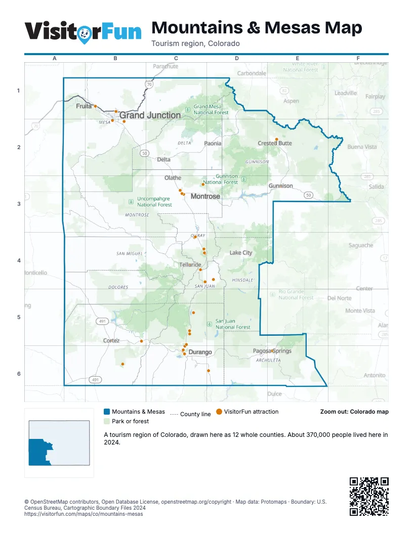
Highway index of Mountains & Mesas
Each highway on the sheet and the grid squares it crosses.
- I-70A1, B1, C1
- US 6A1, B1
- US 50A1, B1, B2, C2, C3, D3, E3, F3
- US 160A6, B5, B6, C5, C6, D6, E5, E6
- US 491A4, A5, B5, B6
- US 550C3, C4, C5, C6, D4
- CO 141B2
Things to do on the Mountains & Mesas map
- Action Adventures Trail Rides
- Adrenaline Driven Adventure Company
- Alpenglow Rentals
- Atomic Legacy Cabin
- Bachelor Syracuse Mine Tour
- Bar D Chuckwagon
- Barons Creek Vineyards
- Black Canyon of the Gunnison National Park
- Buckaroos Horse-Drawn Rides
- Butte & Co.
- Cattlemen's Days Rodeo
- CB Motorsports
- Cliff Palace
- Colorado Outback Adventures
- Dinosaur Journey
- Durango & Silverton Narrow Gauge Railroad
- Durango Flight Tours
- Durango Hot Springs Resort and Spa
- Durango Rivertrippers & Adventure Tours
- Ed's Fly Shop
- Fantasy Ranch Horseback Adventures
- Fox Fire Farms
- Honeyville
- Mesa Verde Stables
- Mild to Wild Rafting & Jeep Tours
- Million Dollar Highway
- Montrose Anglers
- Mountain Paws Dog Sledding
- Old Hundred Gold Mine Tour
- Ouray County Museum
- Ouray Visitor Center
- Red Mountain Motel & RV Park
- RIGS Fly Shop & Guide Service
- Silver Summit RV Park & Jeep Rentals
- Sky Ute Casino Resort
- Soaring Tree Top Adventures
- Telluride Outside
- Telluride Ski Resort
- Telluride Visitors Center
- The Peaks Resort & Spa
- The Powerhouse
- Top Edge Rentals
- United Campground of Durango
- Whitewater Hill Vineyards
- Wilderness Journeys Pagosa
Places on the map
- Cortez
- Crested Butte
- Delta
- Durango
- Fruita
- Grand Junction
- Gunnison
- Lake City
- Montrose
- Olathe
- Pagosa Springs
- Paonia
- Telluride
Next to Mountains & Mesas
- Northern Arizona
- Mystic San Luis Valley map
- Pikes Peak Wonders map
- Rockies Playground map
- The Great West map
- North Central New Mexico
- Northwest New Mexico
- Canyon Country
© OpenStreetMap contributors, Open Database License, openstreetmap.org/copyright · Map data: Protomaps · Boundary: U.S. Census Bureau, Cartographic Boundary Files 2024