

Colorado map
Montrose map
About 21,646 people live here (Census Bureau, 2024 estimate). The sheet's index lists 300 streets; North Townsend Avenue, 6450 Road and 6700 Road cross the most grid squares. Things to do inside the boundary: Ed's Fly Shop, Montrose Anglers and Top Edge Rentals.
Open the map (PDF, US Letter)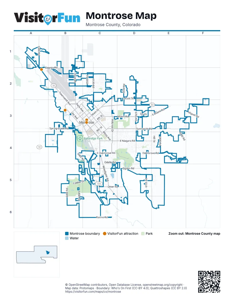
Street index of Montrose
Each street on the sheet and the grid squares it crosses.
- South Townsend AvenueC3, C4, C5
- North Townsend AvenueA1, A2, B2, B3, C3
- East Main StreetC3, D3
- North San Juan AvenueB3, C3
- Spring Creek RoadB3
- West Main StreetB3, C3
- 6700 RoadD2, D3, D4, D5
- 6450 RoadB1, B2, B3, B5, B6
- Sunnyside RoadC3, D3, E3
- Ogden RoadC5, D5, E5
- East Niagara RoadC4, D4, E4
- Woodgate RoadC4, C5, C6, D6
- Locust StreetC2, D2, C3
- South Hillcrest DriveC3, C4
- South Rio Grande AvenueB3, C3, C4, C5
- Miami RoadC3, D3
- East Oak Grove RoadC4, D4
- 6530 RoadC2, C3
- North Grand AvenueB3
- Otter RoadC5, D5
- South 5th StreetC3
- South 2nd StreetC3
- North 2nd StreetB3, C3
- North Park AvenueB3, C3
- South Park AvenueC3, C4
- 6300 RoadA1
- South 12th StreetC3, C4
- North 9th StreetB3, C3
- 6720 RoadD3, D4
- North 4th StreetB3, C3
- South Nevada AvenueC3
- North Nevada AvenueB3, C3
- South Junction AvenueC3
- Kentucky RoadB1
- East Miami RoadC3, D3, E3
- Colorado AvenueC4
- Lincoln RoadB2, C2
- South San Juan AvenueC3
- North Hillcrest DriveC2, C3
- 6600 RoadC2
- Oxbow DriveC5
- Hillcrest DriveC3
- Williams DriveC5
- Chipeta RoadB3
- Oak Grove RoadD4, E4
- Cobble DriveB5, C5
- Otter Pond CircleC5
- Odelle RoadC4, D4, D5
- South Mesa AvenueC3, C4
- 6725 RoadD5
- Meadows ParkwayD4
- North 1st StreetB3, C3
- 6400 RoadB3, B5
- 6900 RoadE3, F3, E4
- Hill StreetE3, D4, E4
- South 1st StreetB3, C3
- 6800 RoadE3, E4
- South 4th StreetC3
- South 3rd StreetC3
- South Cascade AvenueC3, C4
- Airport RoadB2, B3
- Highway 50 Frontage RoadA1, A2, B2
- Racine RoadC6
- North Cascade AvenueB3, C3
- Cimarron Creek DriveC2
- North 7th StreetB3, C3
- Grand Mesa DriveB5, C5
- Riverbottom DriveB4, C4
- Sunset Mesa RoadB4
- Sneffels StreetC4
- North Uncompahgre AvenueB3, C3
- 6485 RoadB4, C4
- North Mesa AvenueB3, C3
- South 11th StreetC3, C4
- North 3rd StreetB3, C3
- Montrose DriveC4
- Launa DriveB2
- Monte Vista CircleD4
- North 8th StreetB3, C3
- North Ute AvenueB3
- American WayD4, E4
- Howard Fork AvenueB4
- South Uncompahgre AvenueC3, C4
- Mahogany DriveD5, E5
- North Selig AvenueB3, C3
- North 5th StreetB3, C3
- Kent AvenueD3, D4
- South 7th StreetC3
- Ridgeline DriveC5
- Mayfly DriveB3
- Miguel RoadF3
- Frontage RoadA1, C6
- Jupiter DriveD4
- Pavilion DriveD4
- County RoadA1, B1, A2, B2
- 6650 RoadD2
- Freedom WayD4, E4
- Dover RoadC3, C4
- Ivy DriveD3
- South 6th StreetC3
- 6500 RoadC2, C6
- La Salle RoadA2, B2, D2
- North 6th StreetB3, C3
- Peppertree DriveD3, D4
- Merchant DriveB3
- Crestview DriveD5, D6
- South 9th StreetC3, C4
- Mead LaneD4, E4
- Haystack RoadC2
- Leeds AvenueD3, D4
- Lilac RoadC2
- James StreetC4, D4
- West Fox Park StreetD4
- San Sophia DriveB5, C5
- Manchester DriveD3, D4
- Bridges DriveD4, D5
- Congress StreetD4, E4
- Natalia WayD4
- Open Field DriveE4
- Pioneer RoadC5, D5, C6
- South 8th StreetC3, C4
- Waterfall DriveC5, D5
- Silver DriveD2
- Hickory DriveD4
- Ironton StreetC4
- Overland DriveE4, F4
- Excelsior Creek AvenueC2
- Big Horn StreetC2
- Diamond Hill StreetC2
- Wolverine DriveC5
- Fivemile Creek AvenueC2
- Weminuche AvenueC2
- Stonebridge DriveD4
- Golden DriveD2
- Outlook RoadD5
- Woodford AvenueC5
- Stratford DriveD3, C4, D4
- Laurel LaneD3
- South 10th StreetC3, C4
- Election WayD4, E4
- W RoadC3
- Angel Trail StreetC2
- Courthouse Peak LaneB5, C5
- South Stough AvenueC3
- 6375 RoadB3, B4
- Blue Creek AvenueC2
- Kellie DriveC5
- Cedar Creek AvenueC3
- Valley WayD4, E4
- Sleeping Bear RoadD4, D5
- Silver Fox DriveD4
- Ridge StreetC3
- Wheat Grass DriveD4
- Spruce DriveC4
- Corral DriveC2
- Chocolate AvenueC4
- South Pythian AvenueC3
- South Lot AvenueC3
- Columbia WayC4
- Deer Trail RoadC2
- Pennsylvania StreetC3
- Pitchfork RoadC2
- Encanto PlaceC4
- Maya WayD4
- Bristol DriveC3, C4
- Brown RoadC4
- Highland StreetC3
- Animas StreetC2
- Akard AvenueC4
- Cirque WayD4
- York StreetC3, C4
- Chatam DriveC4
- South Selig AvenueC3
- Donnegal DriveD5, E5
- Chestnut DriveE5
- Bradford DriveC4, D4
- Ouray DriveD4
- Sara E LaneD4
- Wetterhorn StreetC4
- Ravens Crest DriveD4
- Air Park WayA2, B2
- Columbine LaneD3
- Draft Horse RoadC2
- Centennial DriveC3
- Cambridge StreetC4, D4
- Roxie DriveC5
- Cottonwood DriveD5, D6
- Mount Hayden DriveB5
- Heather LaneD3
- Court WayD4
- Kinikin RoadD6
- Evans StreetC3, D3
- South Grand AvenueB3, C3
- Pecan StreetD4
- Lost Creek Road NorthD4
- Avon DriveC3, C4
- Kestrel LoopD4, E4
- Fellows DriveC4, D4
- Hermosa StreetC4
- Water AvenueB3, C3, C4
- Scarlet CourtE5
- Senate StreetE4
- Galaxy DriveC2
- Red Cliff CircleD4, D5
- X RoadC3
- Lone Tree LaneB5
- North Stough AvenueC3
- Pineview DriveC3
- Apollo RoadC4
- Biron RoadD4
- Constitution LoopE4
- Crossroads CircleC2, C3
- Brook WayC5
- Lost Creek Road SouthD4, D5
- Iris CourtD3
- 6950 RoadF3
- Blue Lake DriveB4
- Nichols WayD4
- Sherwood DriveD3, D4
- Big Pines DriveE4
- Essex StreetC3, D3
- Iron Horse DriveD3
- Majestic CircleD4
- Juniper RoadA1
- Stover AvenueC4
- Black Canyon WayC5
- Devon StreetC3, D3
- Country Club WayD3
- Pinewood StreetD4, E4
- Moonlight DriveC2
- Stoney Creek LaneD3
- Rose LaneC3
- Windsor WayD4
- Buffalograss DriveB4
- Pilot Knob AvenueB4
- Wildwood DriveC5
- Alder DriveD4
- Cimarron Creek LoopB2, C2
- North Cedar AvenueC3
- Winston WayC4, D4
- Abrams AvenueC4
- Arbor WayC4
- Peyton DriveD4
- Prospect DriveB5
- Anderson RoadC4
- Gold Creek DriveB4
- Republic AvenueD4, E4
- Indiangrass LoopB4
- East Star CourtC3
- Phillips CourtD3
- Belle Haven WayD4
- Alta Lakes AvenueB4
- Foxtail DriveD3, D4
- Honey Locust DriveE5
- Aspen StreetC4
- Birch StreetC3, D3
- Crows Nest CourtD4
- Vega DriveD4
- Vista View DriveC3
- Owl Creek AvenueC2
- Princeton WayC4, D4
- Scarborough WayC4, D4
- White House DriveD4
- Linda Vista DriveD4
- Paintbrush WayD3
- Sage DriveD3
- Church StreetC4
- South Willerup AvenueB3
- Tributary StreetB3
- Caboose DriveD3
- Sanctuary DriveB5
- Dry Creek AvenueC2
- Bear Lake DriveC4
- Margo CourtD3
- Glen View DriveD4
- South Forty DriveC2
- Virginia LaneD4
- Vermillion AvenueB4
- Bluegrass CourtB3, B4
- Poplar StreetC4
- Buffalo LaneB5
- Castle AvenueC3
- Shanes WayB3, B4
- Major LaneE4
- Fairview PlaceC3
- Mesa Vista AvenueC3
- E RoadC3
- Kia LaneD4
- Hartford WayC4, D4
- Collins WayB5
- G RoadC3
- Industrial DriveB2
- Saw Grass DriveD4
- Apple Grove StreetE4
- Arizona AvenueC3
- Lone Cone AvenueC4
- West South 1st StreetB3
- Cimarron StreetD4
- Painted Wall LaneC4, D4
- Arland RoadC4
Things to do on the Montrose map
Places on the map
- AATCO Transmission Complete Auto Repair
- Abel's Ace Hardware
- Airport Employee
- All Saints Anglican Church
- all saints comunity garden
- Alpine Bank
- Altrusa
- Ambulatory Care Center
- Applebee's
- Arby's
- Archmont Park
- Axis Health System - Montrose
- Backstreet Bagel
- Baldridge Park
- Beer Barn
- Best Western Montrose Inn
- Bicycle Outfitters
- Big O Tires
- Black Canyon Golf Course
- Black Canyon Jet Center (FBO)
- Cedar Cemetery
- Cedar Creek RV Park
- Cobble Creek Golf Community
- Columbine Middle School
- Economy (North)
- Fox Park
- Johnson Elementary School
- Montrose High School
- North Mesa
- Pomona Elementary School
- Riverbend RV Park
- Riverbottom Park
- Rotary Park
- Short Term (Terminal)
- Target
- The Bridges Golf and Country Club
- The Star Drive-In
- Uncompahgre River
- Ute Park
- Walmart Supercenter
© OpenStreetMap contributors, Open Database License, openstreetmap.org/copyright · Map data: Protomaps · Boundary: Who's On First (CC-BY 4.0); Quattroshapes (CC BY 2.0)















