

Colorado map
Pitkin County map
About 16,643 people live here (Census Bureau, 2024 estimate). The sheet's index lists 300 streets; Frying Pan Road, Dinkle Lake Road and Castle Creek Road cross the most grid squares. Things to do inside the boundary: Aspen, Aspen Mountain and Maroon Bells.
Open the map (PDF, US Letter)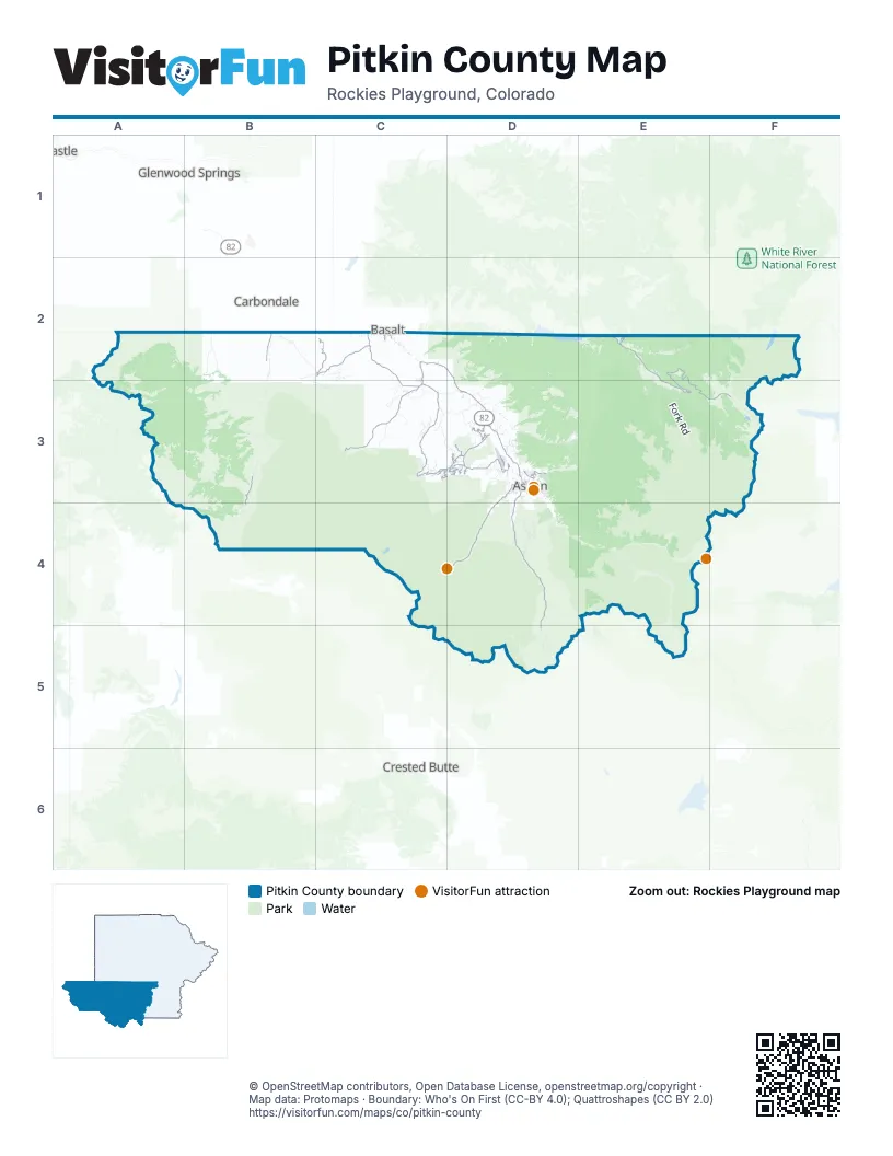
Street index of Pitkin County
Each street on the sheet and the grid squares it crosses.
- Highway 133B2
- West Hallam StreetD3
- West Main StreetD3
- East Main StreetD3
- North 7th StreetD3
- Brush Creek RoadC3, D3
- Owl Creek RoadD3
- East Cooper AvenueD3
- Two Rivers RoadC2
- South Original StreetD3
- Frying Pan RoadD2, E2, E3, F3
- Castle Creek RoadD3, D4, D5
- Snowmass Creek RoadC2, C3
- Capitol Creek RoadC3
- East Sopris Creek RoadC2, C3
- West Sopris Creek RoadC2
- Sopris Creek RoadC2
- Lower River RoadC2, D2, D3
- Maroon Creek RoadD3, D4
- Maroon Lake RoadD4
- McLain Flats RoadD3
- Upper River RoadD3
- Medicine Bow RoadD3
- Redstone BoulevardB3, B4
- Faraway RoadD3
- Red Mountain RoadD3
- Divide RoadC3
- Juniper Hill DriveD3
- Lime Creek RoadE2
- Wood RoadC3, D3
- Horse Ranch DriveD3
- Willoughby LaneD3
- Ridge RoadD3
- Emma West RoadC2
- Two Creeks DriveD3
- Cemetery LaneD3
- Sinclair RoadD3
- Carriage WayC3
- East Airport RoadD3
- Pine Crest DriveD3
- Highline RoadD3
- Forge RoadD3
- Meadow RoadD3
- East Durant AvenueD3
- Emma RoadC2
- Southside DriveC2
- Harmony RoadD3
- Gerbaz WayD3
- Gibson AvenueD3
- Smith Hill WayD3
- Park CircleD3
- South Aspen StreetD3
- Pine LaneC3
- Midland AvenueC2, D3
- North Mill StreetD3
- Basalt AvenueC2
- Airport RoadD3
- Park AvenueD3
- Wood Run RoadC3
- Neale AvenueD3
- Hooks LaneC2
- West Airport RoadD3
- King StreetD3
- Fiou LaneC2
- South AvenueD3
- South Fork RoadE2, E3
- Woody Creek RoadD3, E3
- Lincoln Creek RoadE4
- Nast Tunnel Diversion RoadE3, F3
- Midnight Mine RoadD4
- Prince Creek RoadB2, C2
- Lenado RoadD3, E3
- Middle Cunningham RoadE2, F2
- North Fork RoadE2
- Little Annie RoadD4
- Wildcat WayC3, D3
- Thompson Creek RoadB2
- Coal Basin RoadB3
- Buddy RoadD3
- Lake Wildcat RoadC3, D3
- Hagerman Pass RoadF3
- Lazy O RoadC3
- Cooper Creek RoadD5
- Burnt Mountain RoadE2
- Bear Creek RoadD2, D3
- West Buttermilk RoadD3
- Chapman Creek RoadE3
- Dinkle Lake RoadB2, C2, B3, C3
- South Thompson Creek RoadB2
- Shield O RoadC3
- Sopris Mountain RoadC2, C3
- Kobey Park RoadD3
- Avalanche Creek RoadB3
- Nicholson Creek RoadC3
- Watson Divide RoadC3, D3
- Juniper Hill RoadD3
- Elk Creek RoadC3
- Little Woody Creek RoadD3
- Ziegler Divide RoadC3
- Tie Hack RoadD3
- Dunbar LoopD4, E4
- Owl Creek Ranch RoadD3
- Radar RoadD3
- Light Ranch RoadB2
- Mesa RoadC3
- Cooper Basin RoadD5
- Monastery RoadC3
- Fourmile RoadA2
- Vagneur RoadD3
- Horseshoe Bend RoadE3
- Dorias WayB3
- Smuggler Mountain RoadD3
- Difficult Campground RoadD4
- Rose Spur RoadC3
- Richmond Hill RoadD4
- Ridge Wildcat DriveC3
- McCabe Ranch RoadC3
- North Bill Creek RoadB2
- Gateway RoadC2, C3
- Star Mesa RoadD3
- Trentaz DriveD3
- South Shore DriveD2, E2
- Western Mobile MountainD3
- Redstone Campground North RoadB3
- Thomas RoadB2
- Ziegler Divide WayC3
- Moore DriveD3
- South Starwood DriveD3
- Conundrum Creek RoadD4
- Twining Flats RoadD3
- North Hayden RoadD4
- Carroll DriveD3
- Stage RoadD3
- Popish RoadC3
- Cluny RoadD3
- Aspen Valley Ranch RoadD3
- South Bill Creek RoadB2, B3
- Handy DriveB2
- East Creek RoadB3
- Meadowood DriveD3
- Oak Ridge RoadD3
- Chapman Campground RoadE2, E3
- East Soris Creek RoadC3
- Hunter Creek RoadD3
- White Star LaneD3
- Snowmass Club CircleD3
- West Divide RoadA2, A3
- Chaparral DrD3
- North Thompson RoadB2
- East River Ranch RoadC2
- Mountain Laurel DriveD3
- Holland Hills RoadC2
- Divide DriveC3
- Coal Basin Spur RoadB3
- Bottom of Five RoadC3
- Whitehorse Springs LaneD3
- Buttermilk RoadD3
- Chateau WayC3
- Edgewood LaneC3
- Eppley DriveD3
- Old Heron RoadC2
- Aspen Airport Business CenterD3
- McSkimming RoadD3
- South Hayden RoadD4
- Upper Ranch RoadD3
- Guber RoadD3
- North Thomas RoadB2
- Avalanche RoadB3
- Kessler RoadD3
- East Hopkins AvenueD3
- Daniel DriveD3
- Pioneer Springs Ranch RoadD3
- North Starwood RoadD3
- Rural Mountain RoadC3
- Fox Run DriveD3
- Johnson DriveD3
- Green Fields RoadC2
- 7 Oaks RoadB2
- Spring Creek RoadC2
- Arbaney Ranch RoadC2
- Elk Mountain DriveB3
- Club House DriveD3
- Norrie DriveE2
- Light Hill RoadC2, C3
- Old Herron RoadC2
- Express Creek RoadD4
- Highland RanchD4
- Eaglemont DriveD4
- Jack Gredig LaneD3
- Spruce StreetD3
- Tejas TrailC2
- Miller RoadE2
- Flying Dog Ranch RoadD3
- East Hyman AvenueD3
- Powerline-Cunningham RoadF2
- Spruce Ridge LaneD3
- Woods RoadD3
- Nettel Creek RoadB3
- Horseshoe DriveC2
- Ute AvenueD3
- Terrace DriveD3
- Freeman Day Use Area RoadD2
- Lester LaneC2
- Allen LaneD3
- North River RoadC2
- Nell Erickson RoadD3
- Old Pond WayC3
- Crystal CircleB3
- Bobcat LaneB4
- Running Mare RoadD3
- Service Center RoadD3
- Maple Ridge LaneD3
- West Smuggler StreetD3
- West Bleeker StreetD3
- Glen Eagles DriveD3
- Wildcat VistaD3
- West Francis StreetD3
- Aspen Valley Downs RoadD3
- Roaring Fork RoadD3
- Wright RoadD3
- Red Butte DriveD3
- Aspen Oak DriveD3
- Crystal Lake RoadD3
- Twin Meadows RoadE3
- Badger HollowD3
- North Ridge LaneD3
- Bullwinkle PlaceD3
- West Hopkins AvenueD3
- East Reds RoadD3
- Little Elk Creek AvenueC3
- Wyland WayC2
- South Mill StreetD3
- McFarlane LaneD4
- Sage Rim CircleC2
- Chapman Loop H RoadE3
- Draw DriveD3
- Haystack LaneC3
- Aspen Village RoadD3
- Chair Mountain DriveB4
- Crystal LaneB3
- Parker RoadB3
- Oak Ridge DriveD3
- Stewart RoadD3
- Doolittle DriveD3
- Elk Run DriveC2
- West North StreetD3
- Stark Mesa RoadB2
- Chapman Loop G RoadE3
- Katie Park LaneC2
- Pitkin Iron RdD3
- Branding LaneD3
- Red Oak LaneD3
- Starwood RoadD3
- Jalanda LaneD3
- Aspen Valley Ranch LaneD3
- Upper Snowmass Creek RoadC3
- Red Dog RoadB3
- South Monarch StreetD3
- Meadows RoadD3
- Coach RoadD3
- Apple DriveC2
- Isabella Hay RoadD3
- North 3rd StreetD3
- Hidden Valley RoadD3
- Eastwood RoadD3
- Silver King DriveD3
- Bison LaneB4
- Exhibition LaneD3
- North 4th StreetD3
- Hall DriveD3
- Silverlode DriveD3
- Elk LaneC2, B4
- Rabbit WayC3
- South Galena StreetD3
- High School RoadD3
- Burnt Mountain DriveD3
- Vagneur LaneC2
- West Reds RoadD3
- Cemetery RoadC2
- North 5th StreetD3
- Glen Dee RoadD3
- Larkspur LaneD3
- Stellar LaneD3
- Maroon Creek Ranch RoadD3
- Maple DriveC2
- North Star DriveD3
- Ranch RoadD3
- Deer Ridge LaneD3
- Lemond PlaceD3
- Power Plant RoadD3
- Lake DriveC2
- North 6th StreetD3
- Firehouse RoadB3
- Music School RoadD3
- Crystal Park DriveB4
- Aspen WayC3
- Aspen Alps Road SouthD3
- Morton DriveD3
- East Lupine DriveD3
- Emma East RoadC2
Things to do on the Pitkin County map
Places on the map
- Aspen
- Aspen Golf Course
- Aspen Highlands
- Aspen Mountain
- Aspen Snowmass
- Aspen-Pitkin County Airport/Sardy Field
- Avalanche Ranch
- Bingo Glades
- Buttermilk
- Capitol Lake
- Cathedral Lake
- Chapman Campground
- Chapman Lake
- Crater Lake
- Difficult Campground
- Dinkle Lake
- E=m(SKI)2 Glade
- El Avalanchero Glade
- Grizzly Reservoir
- Homestake Reservoir
- Hunter–Fryingpan Wilderness
- Ivanhoe Lake
- Lewis Lake
- Lost Man Lake
- Lyle Lake
- Marolt Open Space
- Maroon Bells–Snowmass Wilderness
- Maroon Creek
- Maroon Creek Club
- Maroon Lake
- Moore Open Space
- Mount Sopris
- North Mesa
- Roaring Fork River
- Sky Mountain Park
- Snowmass Club
- Snowmass Lake
- Snowmass Village
- Spring Gulch Trail System
- Wildcat Reservoir
Next to Pitkin County
- Basalt
- Carbondale
- Crested Butte
- Glenwood Springs
© OpenStreetMap contributors, Open Database License, openstreetmap.org/copyright · Map data: Protomaps · Boundary: Who's On First (CC-BY 4.0); Quattroshapes (CC BY 2.0)















