

Colorado map
Teller County map
About 24,862 people live here (Census Bureau, 2024 estimate). The sheet's index lists 300 streets; South State Highway 67, West U.S. Highway 24 and Portland Avenue cross the most grid squares. Things to do inside the boundary: Cripple Creek & Victor Narrow Gauge Railroad and Dinosaur Resource Center.
Open the map (PDF, US Letter)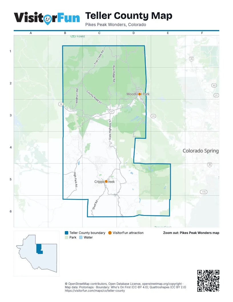
Street index of Teller County
Each street on the sheet and the grid squares it crosses.
- South State Highway 67C3, C4, D4, C5, D5
- West U.S. Highway 24D2, B3, C3, D3
- County Road 81C5, D5
- East U.S. Highway 24D2, D3
- Victor AvenueC5, D5
- Portland AvenueC5, D5, C6
- South 2nd StreetC5, C6
- North 5th StreetC5
- East Bennett AvenueC5
- Diamond AvenueC5
- 3rd StreetC5
- North State Highway 67D1, D2
- Pikes Peak HighwayD3, D4
- Phantom Canyon RoadD5, D6
- North B StreetC5
- West Bennett AvenueC5
- West Carr AvenueC5
- Carr AvenueC5
- High Park RoadB4, B5, B6
- Trail Creek RoadC1, B2, C2
- County Road 51B2, C2, C3
- Rule Ridge RoadC1, D1, C2
- Shelf RoadC5, C6
- Wildhorn RoadB2, B3
- Painted Rocks RoadC1, D1
- County Road 42B3, C3
- County Road 5C2, C3
- Trail Creek Road/County 32B2
- Rampart Range RoadD1, D2
- Trout Creek RoadD2, D3
- County Road 79D1
- County Road 421B3, C3
- Valley View DriveD2, B3, C3
- Tranquil Acres RoadD2, D3
- County Road 112B5
- Crystola RoadD2, D3
- South West StreetD2
- County Road 31B3
- Evergreen Heights DriveD2
- South Woodland AvenueD2
- East Kelley's RoadD2
- North Center StreetD2
- North Baldwin StreetD2
- West Kelley's RoadD2
- County RoadD2
- West Lake AvenueD2
- South Baldwin StreetD2
- North West StreetD2
- East Lake AvenueD2
- South Fairview StreetD2
- North Park StreetD2
- East Midland AvenueD2
- East Sheridan AvenueD2
- East Chester AvenueD2
- West Columbine AvenueD2
- North Fairview StreetD2
- Centre CaminoD2
- Stohl RoadB3
- Aspen Garden WayD2
- Costilla AvenueB3
- Lower Twin Rocks RoadC3
- Gold Camp RoadD5, E5
- Cedar Mountain RoadB1, C1, B2
- Four Mile RoadC4, C5
- Skagway RoadD6
- Pikes Peak DriveB3, C4
- Sioux RoadB5
- Teller County Road 8D5, D6
- County Road 121B3, B4
- West Creek RoadC1
- Haul RoadC5, D5
- County Road 863D6
- Beaver Valley RoadD5
- County Road 12B4
- County Road 111B4, B5
- Wapiti RoadC3, C4
- Teller County Road 782D1, C2, D2
- Pathfinder RoadB2, C2, B3
- Blue Mesa DriveC3
- Spring Valley DriveC2, B4, B5
- North Mountain Estates RoadB4, C4
- Lakemoor DriveB5, C5
- Homestead DriveD3
- Seven Lakes RoadD5, E5
- Southpark RoadC4
- Elk Ranch RoadE5, E6
- Old Hall PlaceB5, C5
- Forest Road 346D1
- Lutheran RoadB1, C1
- County Road 512C3
- Highland Meadows DriveB4
- Edlowe RoadD3
- Teller County Road 863D6
- Signal Rock Ranch RoadB3, C3
- Yorktown RoadC4, C5
- Gold King DriveC4, C5
- Teller County Road 46B3
- Bradley Ranch ViewD6
- Hay Creek RoadC4
- Agnes DriveC4, C5
- Arrowhead RoadC3, C4
- South Mountain Estates RoadB4
- Clyde RoadD5
- May Queen DriveC4, C5
- High Chateau RoadB4
- Vagabond Creek DriveB2
- North Yucca Creek RoadC2
- West Bison Creek TrailB2, C2
- Arapahoe DriveB5
- Arapahoe Creek TrailC2, B3, C3
- County Road 281D3
- Forest Road 345D1
- Mills Ranch RoadD2
- Red Rocks ViewD2
- Kiowa RoadB2
- Apache RoadB5
- Crystal Peak DriveB2
- Spring Creek DriveB2, C2
- Cantiberry RoadC3
- County Road 782C1, D1
- Forest Service Road 336D2
- Elkton and Cresson Mine RoadC5
- Calcite DriveC4
- Kylie Heights DriveD2
- Eaglenest DriveC5, D5
- Golden Cycle CircleC4
- Elk Valley RoadC3
- Old Stage RoadB3
- Circle DriveB3, C3
- Old Ranch RoadB4, C4
- County Road 891C5
- Conestoga Creek RoadB2
- Navajo TrailD2, B3, C4
- Sangre de Cristo ViewB4
- Gold Dust Creek RoadB2
- Fairview DriveC4
- Elkridge SouthC3, D3
- Sunnywood AvenueD2
- Hidden PointC3
- Wind Dancer CircleC4
- County Road 62C3, C4
- Deer Trail DriveB1
- Blossom RoadD2
- East Bison Creek TrailC2
- Forest Service Road 339D2
- Beaver Creek DriveB2
- Coyote TrailD2
- Forest Service Road 391D1
- East Beaver RoadE5, E6
- Wellington DriveC4
- Splendor PointC3
- County Road 511C2, C3
- Lakeview Forest HeightsB4, C4, B5
- Hotel Gulch RoadD1
- Will Scarlet DriveC3
- Monarch DriveB3, C5
- Columbine RoadD2, B3, D3
- Elfin Glen DriveC3
- Troy DriveC5
- Kings Crown RoadD2
- Obsidian DriveB3, C3
- Apache TrailC2, D2, C4
- Crystola Canyon RoadD3
- Saguache DriveC3
- Up High RoadC5
- Penrose CircleC5
- Navajo DriveB5
- Timber Ridge RoadC4
- Dandy Jim DriveC4, C5
- Woodrock WayC4
- Rhyolite Mountain MesaC5
- Rangeview RoadC2
- Markus RoadD3
- Innovation WayD2
- John DriveB2, C2
- Vivenda RoadC4
- West Creek Road (No Public Access)C1
- City Water Department RoadsD5, E5
- Columbine LoopB1
- Ridge RoadC2
- Peaceful GroveC3
- Skyline DriveD2, D3
- Princess RoadC4
- Catamount Road (FS 385)C3, D3
- Teller County Road 861D6
- Fossil Creek RoadB2
- Arrowhead DriveB4
- Pinewood RoadC3, C4
- Summit RoadB1, C1, D3
- Sun Valley DriveD2, D3
- High Pasture RoadB4
- Castle Ridge ViewC4, D4, D5
- Lucky Lady DriveD2
- Twin Lakes DriveC3
- Wilson DriveB3
- Forest Service Road 334CD3
- Midland RoadC3, D3
- Bennett DriveC4, C5
- Pennsylvania AvenueD3, B4
- Yocca Creek DriveC2
- Pike View RoadB5
- Little Topsey DriveC4
- Valley RoadC2, C4
- Spring Valley LaneC4
- Chaparral TrailB4
- Aspen DriveB1, C3, D3
- Crystal Peak RoadB2, B3
- County Road 89C5
- Hackamore DriveB4, C4
- Badger TrailB2, C2, B3
- Divide South DriveC3
- Forest Glen TrailB3
- Cottonwood Lake DriveC3
- Carlton DriveC5
- Trout Creek DriveB2, C2
- Pine RoadB5
- Paridiso RoadC4
- Forest Edge RoadD2
- Centennial GroveC4
- Independence RoadC5, D5
- Maid Marian DriveC3
- Aspen Village RoadC3
- Kutsu Ridge RoadC3
- Vindicator DriveC4, C5
- Kingston DriveC3
- Indian Creek RoadB2
- Lookout RoadC4
- Forest Road 376D5
- Omer RoadC2
- Klitowya TrailD3
- Eagle DriveC4
- Matterhorn DriveB4
- Lake DriveB3, C4
- Remwood CircleC2, D2
- North RoadC2
- Stonehenge DriveC3
- Cheyenne Creek DriveB2
- University DriveD3
- Pinon LaneC4
- Black Mesa CircleB4
- Empire RoadB4
- County Road 24D2, D3
- Kerk RoadB3
- Deer Creek DriveB2
- Bison Creek DriveD5
- North Deer Mountain RoadB4
- Triple B Ranch RoadD2
- Sir Richard DriveC3
- Grey Eagle DriveC4
- Arapahoe Creek DriveC2, C3
- Big Rock PoingC4
- Chateau West DriveB4
- Timber MesaB4
- County Road 781D1
- Commanche TrailB2, B3
- Corral CircleB5
- Willow RoadC4
- Crestridge RoadB3
- Drees DriveB2, B3
- Calle de la LluviaB4
- Ute TrailD2, B3
- Witherite DriveC4
- County Road 84C5, D5
- Beaver Pond RoadC4
- Ute LaneC2
- Winding Valley DriveD3
- Turkey Creek DriveC1
- Meadow Park DriveC3
- Frontage RoadD2
- Blackhawk Creek DriveC2
- Pinecrest RoadD2
- South Park StreetD2
- Copper Mountain DriveC5
- Forge DriveC4
- Trout Lake RoadC3
- Shavano CircleB2, B3
- Creek Side DriveD3
- Trout Haven RoadC3
- Mollie Kathleen RoadC5
- Ridge DriveC3
- Horseshoe DriveC4
- Woodland West DriveD3
- Calle de la NievaB4
- Appleby DriveC1
- Overlook CircleC1
- Valley DriveC1, C3
- Lake Drive WestC2
- Forest Service RoadD2
- Bear Mountain RoadB3
- Spring Valley CircleD2
- Coyote Trail (North)D2
- Moffat DriveC5
- Cochetopa RoadC3
- Crescent DriveB4
- Columbine PlaceD3
- Pawutsy RoadC3
- Comanche RoadB5
- Jolly Rogue DriveC3
- Midnight LaneB3
- Ptarmigan DriveD2
Things to do on the Teller County map
Places on the map
- Almagre Mountain
- Battle Mountain
- Beacon Hill
- Beasley Hills
- Big Bull Mountain
- Bison Park Reservoir
- Black Mountain
- Booger Red Hill
- Brind Mountain
- Buffalo Rock
- Burgess Reservoir Number 1
- Colorado Campground
- Conifer Ridge Campground
- Cripple Creek
- Crystal Creek Reservoir
- Florissant Fossil Beds National Monument
- Manitou Park Lake
- Mason Reservoir
- McReynolds Reservoir
- Mountain View Adventure Park
- Mueller State Park
- Myth Disc Golf Course
- North Catamount Reservoir
- North Slope Recreation Area
- Penrose-Rosemont Reservoir
- Pikes Peak Regional Hospital
- Pringtime Reservoir
- Revenuer's Ridge Campground
- Rule Creek Reservoir
- School Pond Loop
- Shining Mountain Golf Club
- Skagway Reservoir
- South Catamount Reservoir
- South Meadows Campground
- The Cripple Creek & Victor Gold Mine
- Victor
- Victor Reservoir Number 2
- Wapiti Road
- Woodland Park
- Wrights Reservoir
Next to Teller County
- Colorado Springs map
- Manitou Springs
© OpenStreetMap contributors, Open Database License, openstreetmap.org/copyright · Map data: Protomaps · Boundary: Who's On First (CC-BY 4.0); Quattroshapes (CC BY 2.0)















