

Colorado map
Pikes Peak Wonders map
The sheet's index lists 13 highways; US 24, US 50 and I-25 cross the most grid squares. Things to do inside the boundary: AVA Rafting & Zipline, Bishop Castle and Cave of the Winds Mountain Park. Also on it: Black Forest, Buena Vista and Cañon City.
Open the map (PDF, US Letter)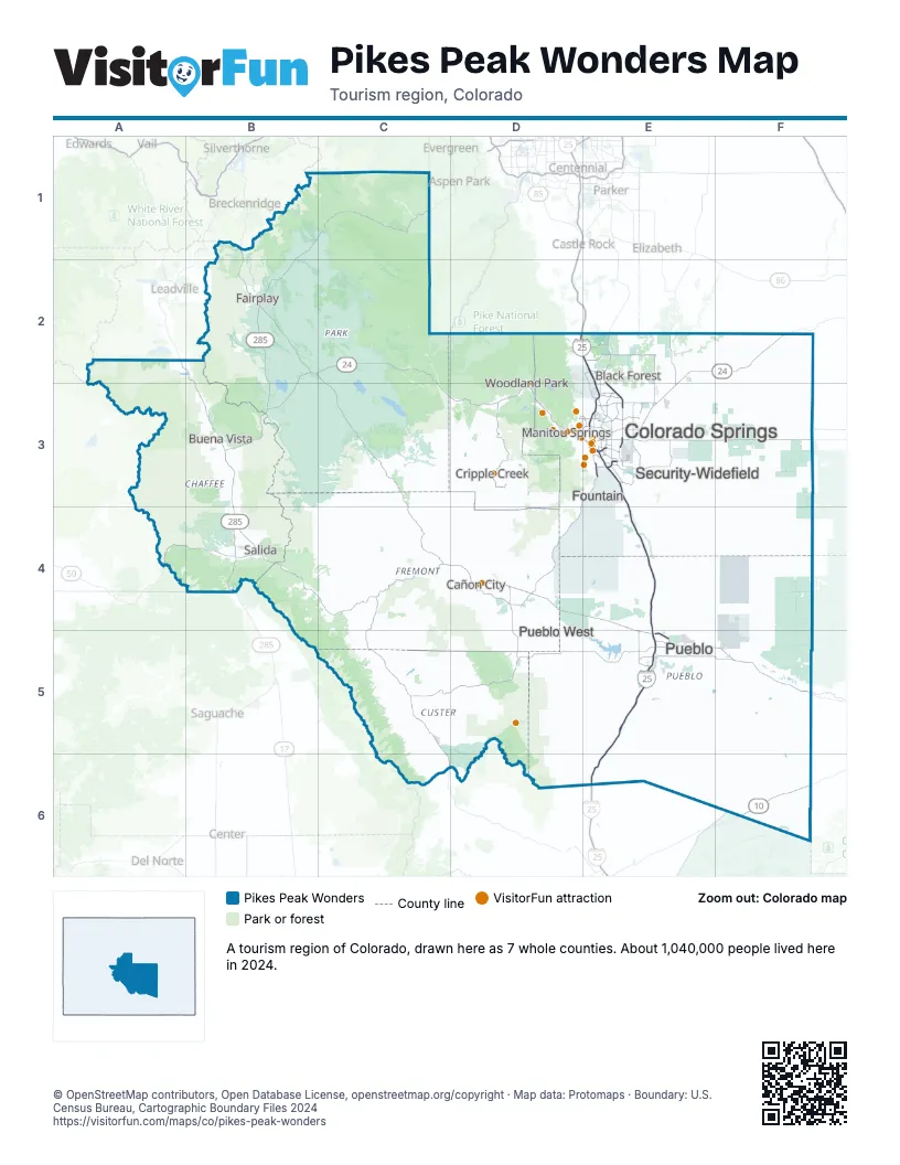
Highway index of Pikes Peak Wonders
Each highway on the sheet and the grid squares it crosses.
- I-25D2, E2, E3, E4, E5, E6
- US 24B2, B3, C2, C3, D2, D3, E2, E3, F2
- US 50A4, B4, C4, D4, E4, E5, F5
- US 285B1, B2, B3, B4, C1
- CO 9B1, B2
- CO 10F6
- CO 16E3
- CO 21E2, E3
- CO 47E5
- CO 67D3
- CO 83E2
- CO 96E5, F5
- CO 115D3, D4, E3
Things to do on the Pikes Peak Wonders map
- AVA Rafting & Zipline
- Bishop Castle
- Cave of the Winds Mountain Park
- Chapel Hills Mall
- Cheyenne Mountain Zoo
- Colorado Springs Visitor Information Center
- Cripple Creek & Victor Narrow Gauge Railroad
- Dinosaur Resource Center
- Downtown Colorado Springs
- Echo Canyon River Expeditions
- Edelweiss Restaurant
- Edward C. Rochette Money Museum
- Flying W Ranch
- Garden of the Gods
- Garden of the Gods Trading Post
- Manitou Cliff Dwellings Museum
- Manitou Incline
- Open Road Rentals
- Pikes Peak - America's Mountain
- Raft Masters
- Rocky Mountain Food Tours
- Royal Gorge Bridge & Park
- Royal Gorge Route Railroad
- The Broadmoor
- United States Air Force Academy
- US Olympic & Paralympic Museum
Places on the map
- Black Forest
- Buena Vista
- Cañon City
- Colorado Springs
- Cripple Creek
- Fairplay
- Fountain
- Manitou Springs
- Pueblo
- Pueblo West
- Salida
- Security-Widefield
- Woodland Park
Next to Pikes Peak Wonders
© OpenStreetMap contributors, Open Database License, openstreetmap.org/copyright · Map data: Protomaps · Boundary: U.S. Census Bureau, Cartographic Boundary Files 2024