

Connecticut road map
Connecticut highway map
8 Interstate routes run about 330 miles in Connecticut, each on a sheet of its own. The sheet's index lists 46 highways; I-95, US 6 and I-84 cross the most grid squares. Towns on it: Bridgeport, Stamford and New Haven.
Open the map (PDF, US Letter)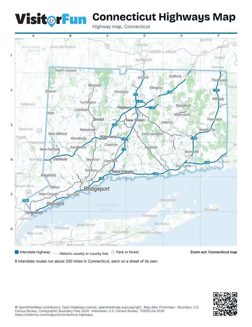
Road maps of Connecticut
9 road maps: each Interstate and byway on a sheet of its own.
Highway index of Connecticut
Each highway on the sheet and the grid squares it crosses.
- I-84A4, B4, C3, D2, D3, E1, E2
- I-91C3, C4, D1, D2, D3
- I-95A5, A6, B5, C4, C5, D4, E4, F4
- I-291D2
- I-384D2, D3
- I-395E3, E4, F1, F2, F3
- I-684A5
- I-691C3
- US 1C4, E4
- US 5C3, D2, D3
- US 6A4, B4, C3, D2, D3, E2, E3, F2
- US 7A4, B1, B3, B4, B5
- US 44A2, B1, B2, C2, D2
- US 202A4, B2, B3, B4, C2
- CT 2D2, D3, E3, F4
- CT 2AE3, E4
- CT 3D3
- CT 8B2, B3, B4, B5, C2, C3, C4
- CT 9C3, D3, D4, E4
- CT 10C2, C3, C4
- CT 11E3, E4
- CT 12E3, E4, F2
- CT 15A5, B5, C3, C4, C5, D2, D3
- CT 17D3
- CT 20D2
- CT 25B4, B5
- CT 32E3, E4
- CT 33B5
- CT 34C4
- CT 40C4
- CT 41B2
- CT 66C3, D3, E3
- CT 67B3
- CT 68C4
- CT 69C3
- CT 70C4
- CT 72C3
- RI 78F4
- CT 82E4
- CT 85E4
- CT 106B5
- CT 183C2
- CT 184E4
- CT 201F4
- CT 272B2
- CT 349E4
Places on the map
- Bridgeport
- Bristol
- Cheshire
- Danbury
- East Hampton
- East Lyme
- Ellington
- Enfield
- Fairfield
- Greenwich
- Haddam
- Hamden
- Hartford
- Hebron
- Jewett City
- Kent
- Killingly
- Litchfield
- Mansfield
- Montville
- New Britain
- New Canaan
- New Fairfield
- New Haven
- New Milford
- North Canaan
- Plainfield
- Ridgefield
- Seymour
- Sharon
- Shelton
- Simsbury
- Southbury
- Stafford
- Stamford
- Thompson
- Torrington
- Waterbury
- Watertown
- Willimantic
- Wilton
- Winsted
- Woodbury
© OpenStreetMap contributors, Open Database License, openstreetmap.org/copyright · Map data: Protomaps · Boundary: U.S. Census Bureau, Cartographic Boundary Files 2024 · Interstates: U.S. Census Bureau, TIGER/Line 2026















