

Delaware map
Wilmington map
About 73,176 people live here (Census Bureau, 2024 estimate). The sheet's index lists 300 streets; North Washington Street, Wilmington Expressway and North Market Street cross the most grid squares. Things to do inside the boundary: Brandywine Zoo, Delaware Art Museum and Wilmington & the Brandywine Valley.
Open the map (PDF, US Letter)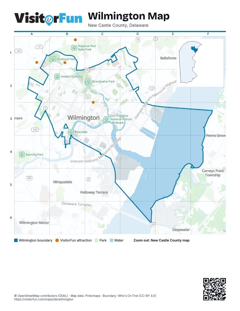
Street index of Wilmington
Each street on the sheet and the grid squares it crosses.
- Wilmington ExpresswayC2, D2, C3, C4, B5, C5
- Vietnam Veterans Memorial HighwayF4, E5, F5, D6, E6
- North Market StreetE2, F2, D3, E3, C4, D4
- East 12th StreetD3, D4, E4, F4, F5
- Northeast BoulevardE3, F3, D4, E4
- Delaware AvenueB1, B2, C2, C3, D3
- West 4th StreetA3, B3, C3, C4, D4
- West 2nd StreetA3, B3, B4, C4
- North Monroe StreetE1, D2, E2, C3, C4
- North Madison StreetE1, D2, E2, C3, C4
- Lancaster AvenueA3, B3, B4, C4
- West 11th StreetB2, B3, C3, D3
- North Church StreetE2, D3, E3, D4, D5
- Pennsylvania AvenueA2, B2, C3
- North Union StreetB2, C2, B3
- South Heald StreetD4, D5, D6
- North Lincoln StreetB2, C2, B3
- North Walnut StreetD3, D4
- Concord AvenueD2, D3
- North King StreetD3, C4, D4
- South Walnut StreetD4, C5, D5
- Maryland AvenueB4, C4, B5
- South Market StreetC4, C5
- North Jackson StreetC3, C4
- North Adams StreetC3, D3, C4
- South Union StreetB3, A4, B4
- East 4th StreetD4, D5
- New Castle AvenueD5, D6
- Martin Luther King BoulevardC4
- East 11th StreetD3, D4, E4
- North Spruce StreetD4
- East Front StreetC4, D4, D5
- West 12th StreetB2, C3, D3
- Governor Printz BoulevardE3, F3
- South Lincoln StreetB3, B4
- Wilmington AvenueB4, D6
- East 16th StreetD3
- East 2nd StreetC4, D4
- South Jackson StreetC4
- D StreetD5
- Adams StreetC3
- South Adams StreetC4
- Kennett PikeA2
- South Dupont RoadA3
- South Monroe StreetC4
- Robert Kirkwood HighwayA4
- Lancaster PikeA3
- North Washington StreetF1, D2, E2, F2, C3, D3, C4
- Christiana AvenueD5, E5, E6
- West 10th StreetB3, C3, D3
- Hay RoadF4, F5
- Baynard BoulevardD1, D2, D3
- North West StreetC3, D3, C4
- South Justison StreetC4, C5
- East 10th StreetD3, D4
- North Dupont RoadA2, A3
- Terminal AvenueD6, E6
- North Jefferson StreetD2, E2, C3, D3, C4
- West 5th StreetA3, B3, C3, C4, D4
- North Broom StreetD1, C2, D2, B3, C3, B4
- North Harrison StreetC2, D2, E2, C3, C4
- Tatnall StreetE2, F2, D3
- West 18th StreetB2, C2, D2, D3
- West 19th StreetB1, B2, D2, D3
- A StreetC5, D5
- North Dupont StreetC2, B3
- Greenhill AvenueB1, B2, A3, B3
- Lovering AvenueC2, C3
- Gilpin AvenueB2, C2, C3
- North Clayton StreetC2, B3, C3, B4
- West Lea BoulevardE1, F1, F2
- Judy Johnson DriveB5, C5
- West 17th StreetB1, B2, D3
- Vandever AvenueD3, E3, E4
- Beech StreetB4, C4, C5
- South Broom StreetB4
- Miller RoadD1, E1
- Hausel RoadE6
- South Madison StreetC4, C5
- East 5th StreetD4
- South West StreetC4
- Read StreetB4, C4
- Augustine RoadC2
- Rising Sun LaneB1, A2
- East 6th StreetD4
- Brinckle AvenueB1, B2
- Howard StreetC5
- Pettinaro Park DriveC5
- Lower Beech StreetB4, C4
- Water StreetC4
- South Tatnall StreetC4
- East Lea BoulevardF2
- North Van Buren StreetE1, C2, D2, E2, C3, C4
- West 6th StreetA2, A3, B3, C3, C4, D4
- West 3rd StreetA3, B3, C4
- West 7th StreetB3, C3, C4, D4
- West 9th StreetB3, C3, D3, D4
- West 8th StreetB3, C3, C4, D4
- South Park DriveC2, C3, D3
- North Bancroft ParkwayB2, C2, B3
- East 7th StreetD4, E4, E5
- West StreetD2, E2, F2, B3, D3
- Woodlawn AvenueB2, C2, B3
- North Scott StreetB2, C2, B3
- North Franklin StreetC2, D2, C3, B4, C4
- North Rodney StreetC2, B3, C3, B4
- West 14th StreetB2, C2, C3, D3
- Bowers StreetE3, F3, E4
- North Claymont StreetE3, F3, E4
- Linden StreetA3, B3, B4, C4
- Shipley StreetE2, F2, D3, C4, D4
- East 8th StreetD4, E4
- Shallcross AvenueB2, C2, C3
- North Grant AvenueC1, B2, C2, B3
- Tower DriveB1
- East Matson Run ParkwayE1, E2, F2
- North Bancroft Parkway SouthB3
- Chestnut StreetB3, B4, C4
- Pine StreetE2, D3, E3, D5
- North Orange StreetD3, C4, D4
- West 16th StreetB2, C2, D3
- South Bancroft ParkwayB3, A4, B4
- West 13th StreetB2, C2, C3, D3
- North Locust StreetF2, E3, F3, D4, E4
- South Claymont StreetD5, D6
- Thatcher StreetE3, F3, E4
- North Park DriveC2, D2, D3
- North Heald StreetE3, F3, E4
- Sycamore StreetA4, B4, C4
- West 37th StreetE1, E2
- Maple StreetB4, C4
- East 27th StreetE3, F3
- West 34th StreetE1, E2
- West 27th StreetD2, E2, E3
- West 28th StreetD2, E2
- West 25th StreetD2, E3
- West 29th StreetD2, E2
- West 30th StreetD1, E2
- Todds LaneE2, E3, F3
- West 20th StreetD2, D3
- Jessup StreetE2, D3, E3
- 14th StreetD3, E3, E4
- Park DriveB1, C2, D2
- East 23rd StreetD3, E3
- Franklin StreetC2, D2
- West 23rd StreetD2, D3
- East 22nd StreetD3, E3
- West 22nd StreetD2, D3
- West Matson Run ParkwayE1, E2
- Sico RoadE6
- West 21st StreetD2, D3
- Eastlawn AvenueE2, E3, F3
- West 38th StreetE1, E2
- West 24th StreetD2, D3
- North Tatnall StreetD3, C4, D4
- West 26th StreetD2, E2, E3
- East 26th StreetE3
- South Clayton StreetB4
- Kentmere ParkwayB1, B2, C2
- East 28th StreetE2, E3
- West 31st StreetE2
- Elm StreetB4, C4
- West 39th StreetE1, E2
- Oak StreetB4
- East 9th StreetD4
- South Franklin StreetB4
- Red Oak RoadB1, B2
- Riverview AvenueB1, B2
- North Pine StreetD4
- Garasches LaneC5, D5, D6
- Bayard AvenueB3
- North French StreetD3, D4
- East 13th StreetD3, E4
- Riddle AvenueC1, C2
- East 30th StreetE2, E3
- Shipyard DriveC5
- Cedar StreetB4, B5
- Wood RoadC1, C2
- Duncan StreetC4, B5, C5
- West 32nd StreetE1, E2
- Rosemont AvenueE3, F3, E4
- Conrad StreetA3, B3, C4
- Milton DriveE1, F1
- East 35th StreetE2, F2, F3
- Lombard StreetD4
- West 36th StreetE2
- Carter StreetE2, D3, E3
- South Harrison StreetB4, C4
- Blackshire RoadB2, B3
- West 35th StreetE2
- Gist RoadE6
- Berth RoadE6, F6
- East 24th StreetD3, E3
- Clifford Brown WalkD3, D4
- 16th StreetE3, E4
- Spruce StreetE2, E3
- South Dupont StreetB3, B4
- South Scott StreetB3, B4
- East 3rd StreetC4, D4
- South Rodney StreetB4
- Nottingham RoadB2, B3
- Hawthorne DriveE1, F1, F2
- Brown StreetB4, B5
- Anchorage StreetB4, B5
- Swedes Landing RoadD4
- South Van Buren StreetB4, C4
- South Buttonwood StreetD5
- Coleman StreetB5
- Rockford RoadB1, B2
- River RoadF6
- Lamotte StreetD3, E3
- Prospect RoadA4
- Townsend StreetD5
- North Cleveland AvenueA3
- Willard StreetB1, B2
- Geddes StreetB3, A4, B4
- East 17th StreetD3, E3
- Bennett StreetD4
- Christina Landing DriveC5
- West 40th StreetE1, E2
- Hawley StreetA3, B3
- 7th AvenueB4, B5
- Taylor StreetD4
- Railroad AvenueE4, D5
- Delamore PlaceB3, B4
- Hill RoadB1, C1
- Kirkwood StreetD4
- West 33rd StreetE2
- High Speed WayB5
- Wawaset StreetC2, C3, D3
- Banning StreetB4
- Tulip StreetB3, B4
- B StreetD5
- Howland StreetB3
- East 29th StreetE2, E3, F3
- Franklin PlaceE1, E2
- Mount Salem LaneB2
- East 25th StreetE3
- Mill RoadC1, C2
- Wilson StreetD3, D4
- Commerce StreetD5, E5
- Tower RoadB1, B2
- South Sycamore StreetA3, B3, A4
- 5th AvenueB4, B5
- 8th AvenueB5
- 6th AvenueB4, B5
- Edgemoor AvenueF3
- McCabe AvenueD2
- Lobdell StreetD5
- Rodman RoadA4
- Channing RoadE1, F1
- Rodman StreetA3, B3
- C StreetD5
- Irving DriveE1, F1
- Bradford StreetD5
- Gray AvenueA3
- Ford AvenueA3
- Brandywine Falls RoadB1
- North Lombard StreetD4
- East 14th StreetD3
- Coverley RoadE1
- 9th AvenueB5
- Webb StreetA3
- New York AvenueD6
- New Sweden StreetC5
- Wilmington Industrial ParkE4
- Pyle StreetB3
- Windsor StreetC3, C4
- Wollaston StreetC3, C4
- Speakman PlaceE3
- Barrett StreetE2
- McDonough RoadB2, B3
- South Connell StreetB4
- Swarthmore RoadA2
- West 41st StreetE2, F2
- Stroud StreetB4, B5
- Bancroft Mill RoadB1, C1
- East Twentyfourth StreetE3
- Ogle AvenueA3
- Poplar StreetD4
- Lafayette BoulevardC4
- Pleasant StreetB4, C4
- Whittier RoadE1
- Container RoadE6
- 15th StreetE4
- East 15th StreetD3
- Wright StreetB5
- North Connell StreetC3, B4
- Towne Estates DriveB4
- Glen AvenueD3
- Field RoadC2
- Wilmington Transit Center Elevated Parking GarageD4
- Coleridge RoadE1
- Atkins AvenueA3
- Townsend PlaceD5
- Ferris StreetB3
- Justison StreetC5
- Seneca RoadA4
- 13th StreetE4
- Moore StreetE2, E3
Things to do on the Wilmington map
Places on the map
- Babiarz Park
- Bancroft Mills
- Bayard Middle School
- Baynard Boulevard Historic District
- Brandywine Park
- Brandywine Park and Kentmere Parkway
- Brandywine Village Historic District
- Brandywine Zoo
- Brown Burton Winchester Park
- Christiana Care Health Services - Wilmington Hospital
- Christina Park
- Cool Spring Park Historic District
- Cool Springs East Park
- Cool Springs Park
- CSW / CCSA Campus
- Delaware Avenue Historic District
- East Brandywine Historic District
- East Side Charter School
- Eden Park
- Eighth Street Park Historic District
- Fort Christina National Historic Landmark
- Frawley Stadium
- H. Fletcher Brown Boys Club
- Haynes Park
- Holden Parkway
- Kentmere Parkway
- Kingswood Community Center
- Kirkwood Park
- Kosciuszko Park
- La Biblioteca del Pueblo Library
- Lower Market Street Historic District
- Matson Run Parkway
- New Castle County Courthouse
- Quaker Hill Historic District
- Riverview Cemetery
- Riverwalk
- Rockford Park
- Salesianum School
- Shipley Run Historic District
- Wawaset Park Historic District
Next to Wilmington
- Alapocas
- Alban Park
- Ashley
- Ashley Heights
- Augustine
- Augustine Hills
- Cleland Heights
- Clifton Park Manor
- Colonial Heights
- Delaware Junction
- Eden Park Gardens
- Elmhurst
- Georgian Terrace
- Hamilton Park
- Henry Clay
- Idela
- Lancaster Village
- Latimer Estates
- Middleboro Crest
- Middleboro Manor
- Millside
- Penn Rose
- Pennyhill
- Richardson Park
- Ridgewood
- Rock Manor
- Rockwood Woods
- Silver Springs
- Silverbrook Gardens
- Stonehaven
- West Haven
- Westover Hills
© OpenStreetMap contributors, Open Database License, openstreetmap.org/copyright · Map data: Protomaps · Boundary: Who's On First (CC-BY 4.0)