

Delaware map
New Castle County map
About 588,093 people live here (Census Bureau, 2024 estimate). The sheet's index lists 12 streets; Korean War Veterans Memorial Highway, Wilmington Expressway and Delaware Turnpike cross the most grid squares. Things to do inside the boundary: Delaware Art Museum, Delaware Museum of Nature & Science and Fort Delaware.
Open the map (PDF, US Letter)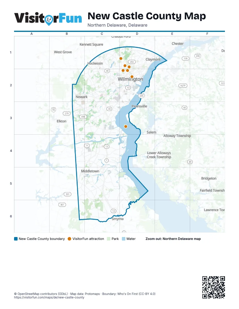
Street index of New Castle County
Each street on the sheet and the grid squares it crosses.
- Vietnam Veterans Memorial HighwayD1, E1, D2
- Wilmington ExpresswayD1, E1, C2, D2
- Delaware ExpresswayE1
- Delaware TurnpikeC2, D2, B3, C3
- Korean War Veterans Memorial HighwayC2, C3, C4, C5, C6
- North Basin RoadC2
- Stanton Christiana RoadC2
- Delaware Memorial BridgeD2
- John F. Kennedy Memorial HighwayB3
- South Dupont HighwayC3
- First Responders Memorial HighwayC4, B5
- Blue Star Memorial HighwayB5
Things to do on the New Castle County map
Places on the map
- Academy Hill
- Achmester
- Alapocas Run State Park
- Anvil Park
- Ardencroft
- Ardens Historic District
- Ardentown
- Ashbourne Hills
- Ashton Historic District
- Auburn Valley State Park
- Bancroft Mills
- Banning Park
- Barb's Farm
- Bayberry South
- Bear
- Bear Crossing
- Becks Pond
- Bellefonte
- Bidermann Golf Course
- Blackbird State Forest
- Blackbird State Forest - Cypress Complex
- Branch Canal
- Brandywine Country Club
- Brandywine Creek State Park
- Brandywine Park
- Brookside
- Cedar Swamp Rocks Tract
- Cedar Swamp Wildlife Area
- Chestnut Hill Trail
- Christiana Fashion Center
- Christiana Hospital
- Churchmans Marsh
- Claymont
- Colton Meadows
- David English Trail
- Deerfield
- Delaware City
- Delaware City Refinery
- Delaware National Estuarine Research Reserve
- Delaware Psychiatric Center
Next to New Castle County
- Alloway Township
- Avondale
- Bridgeton
- Chadds Ford
- Chester
- Elkton
- Fairfield Township
- Greenwich Township
- Hopewell Township
- Kennett Square
- Lawrence Township
- Lower Alloways Creek Township
- Mantua Township
- Oxford
- Pennsville
- Salem
- Smyrna
- West Deptford Township
- West Grove
© OpenStreetMap contributors (ODbL) · Map data: Protomaps · Boundary: Who's On First (CC-BY 4.0)