

Florida map
Boca Raton map
About 102,238 people live here (Census Bureau, 2024 estimate). The sheet's index lists 300 streets; Northwest 5th Avenue, Northwest 4th Avenue and Glades Road cross the most grid squares. Things to do inside the boundary: Boca Raton History Museum, Boca Raton Museum of Art and Gumbo Limbo Environmental Complex.
Open the map (PDF, US Letter)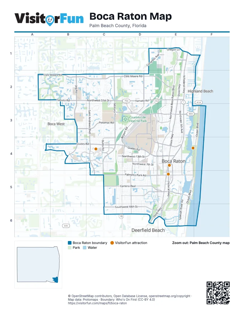
Street index of Boca Raton
Each street on the sheet and the grid squares it crosses.
- Glades RoadA4, B4, C4, D4, E4
- North Federal HighwayE1, E2, E3, E4
- Yamato RoadB2, C2, D2, E2
- West Palmetto Park RoadC5, D5, E5
- Federal HighwayE1, E4, E5, E6
- Northwest 51st StreetB2, C2
- East Palmetto Park RoadE5
- Northwest 24th CircleC2, C3
- Clint Moore RoadA2, B2, C2, D2, E2
- North Military TrailC2, C3, C4, C5, C6
- North Dixie HighwayE1, E2, E3, E4, E5
- Jog RoadB2, B3, B4
- Northwest Spanish River BoulevardC3, D3, E3
- Southwest 18th StreetC6, D6, E6
- Congress AvenueD1, E1, D2
- North Ocean BoulevardF3, E4, F4, E5
- South Dixie HighwayE5, D6, E6
- South Ocean BoulevardE5, E6
- Northeast Spanish River BoulevardE3, F3
- Powerline RoadB4
- Royal Palm WayE5, E6
- Town Center RoadC4
- Butts RoadC4
- Northeast Mizner BoulevardE4, E5
- Southeast Mizner BoulevardE5
- Northwest 82nd StreetE1
- Northeast 8th StreetE4
- South Military TrailC5, C6
- Dixie FlyoverD6
- Southeast 5th StreetE5
- North Ocean DriveE6
- Saint Andrews BoulevardC2, C3, C4, C5
- West Camino RealC5, D5, E5
- Northwest Boca Raton BoulevardE1, E2, E3
- Northwest 13th StreetC4, D4, E4
- Northwest 5th AvenueE1, E2, D3, E3, D4, D5
- Northeast 5th AvenueE2, E3, E4, E5
- Northwest 4th AvenueE1, E2, E3, D4, E4, D5
- Potomac RoadB3, C3
- Northwest 2nd AvenueE3, E4, E5
- Airport RoadD3, C4, D4
- Northwest 20th StreetD4, E4
- FAU BoulevardD3
- Camino Gardens BoulevardD5, E5
- East Camino RealE5
- East University DriveD3, D4
- Northwest 8th StreetC4, D4, E4
- Southwest 12th AvenueD5
- North University DriveD3, D4
- Northwest 12th AvenueD4, D5
- Northwest 7th AvenueD2, D3, D4, D5
- Southwest 4th AvenueD5, E5, D6, E6
- Technology WayD2, D3
- South Verde TrailB4, C4
- Northwest 15th AvenueD2, D4
- Northeast 2nd StreetE5
- Southwest 13th StreetC5, D5, E5
- Northeast 20th StreetE4
- West University DriveD4
- Northwest 35th StreetC3, D3, E3
- Northwest 8th AvenueD2, D3
- Northwest Broken Sound BoulevardD2, D3
- Northwest 15th StreetD4, E4
- Northwest 19th StreetC4, E4
- Verde TrailB4
- Juana RoadD5, D6
- East Country Club BoulevardE1
- North Verde TrailB4, C4
- Northwest 6th WayD3
- Northwest 28th StreetB3, C3, D3, E3
- Northwest 9th CourtD4
- Southeast 3rd StreetE5
- West Hidden Valley BoulevardE1
- Northwest Executive Center DriveC4
- Meadows RoadD4
- Northwest 10th AvenueD4, D5
- East Hidden Valley BoulevardE1
- Renaissance WayC4
- Brant DriveE1
- Commercial TrailC4
- Northwest 2nd StreetE5
- Woodfield CircleA2, B2
- Broken Sound Parkway NorthwestC2, D2
- Northwest 3rd AvenueE1, E2, E3, E4
- Willow Springs DriveB2, C2
- Northeast 4th AvenueE2, E3, E4, E5
- Northwest 7th StreetC4, D4, E4
- Northwest 6th AvenueD1, E1, D3, D4, D5
- Southwest 17th StreetC6, D6, E6
- Coco Plum BoulevardB2, C2
- Boca BayouD6, E6
- Northwest 53rd StreetA2, B2, C2, D2, E2
- Northwest 55th DiagonalB2
- Northeast 6th DriveE2, E3
- Northwest 24th TerraceC2, C3
- Windwood BoulevardE3
- Northwest 59th StreetB2, C2
- Woodfield BoulevardB2, B3
- Southwest 2nd StreetC5, D5, E5
- Northwest 1st AvenueE3, E4, E5
- Banyan Boulevard Circle NorthwestC3
- Southwest 15th StreetC5, D5, E5
- Southwest 3rd StreetD5, E5
- Park of Commerce BoulevardD2
- Spanish River RoadE5, E6
- Southwest 16th StreetC5, C6, D6, E6
- Northwest 67th StreetB2, C2, E2
- Northwest 25th WayB2, C2, C3, C4
- Banyan RoadE5, E6
- Southwest 2nd AvenueE5, E6
- Pine Haven CircleC3
- Northeast 7th AvenueE1, E2
- Northwest 27th AvenueB2, B3, B4
- Northwest 55th StreetB2, C2, E2
- Northwest 4th StreetC4, D4, E4
- Southwest 4th StreetC5, D5, E5
- Southwest 5th StreetD5, E5
- Broken Sound Boulevard NorthwestD2
- Southwest 14th StreetC5, D5, E5
- Northwest 23rd WayC2, C3
- Southwest 7th StreetC5, D5, E5
- Northwest 24th WayC2, C3
- West Royal Palm RoadD5, E5
- Northwest 64th BoulevardB2, C2
- Thatch Palm DriveE5, E6
- Southwest 20th StreetC6, D6
- Palm Beach AvenueD3, D4
- Jeffery StreetE2, F2
- Northwest 24th AvenueC2, C3
- Northwest 26th AvenueC2, B3, C3, B4
- Southwest 9th AvenueD5
- Southwest 22nd Avenue CircleC5, C6
- Southwest 14th DriveC5, D5
- Northwest 46th StreetB3, C3, E3
- Northeast 2nd AvenueE3, E4
- Southwest 1st StreetD5, E5
- Southeast 5th AvenueE5
- Southwest 19th StreetC6, D6
- Estrella CircleA4, B4
- Southwest 21st StreetD6
- Northwest 23rd TerraceC2, C3
- Southwest 9th Street CircleC5
- Northwest 26th CourtB2, B3, B4
- Northwest 32nd StreetB3, C3, D3
- Northeast 3rd AvenueE4, E5
- Timbercreek Circle NorthwestC3
- Northwest 60th CircleA2, C2
- Coconut RoadE5, E6
- Northwest 64th StreetB2, C2, E2
- Sabal Palm DriveE5, E6
- Northwest 63rd StreetB2, C2
- Northwest 6th StreetD4, E4
- Southwest 21st LaneD6
- Northwest 44th CircleC3
- Water CircleC6
- Southwest 21st AvenueC5
- Northwest 52nd StreetA2, B2, C2, E2
- Southwest 15th AvenueD5
- Southwest 8th StreetC5, D5, E5
- El Paseo RoadB4
- Northwest 23rd CourtC2, C3
- Northwest 41st StreetB3, C3
- Coach House CircleC5
- Southwest 13th PlaceC5, D5, E5
- Northwest 10th StreetC4, D4, E4
- East Boca Raton RoadE5
- Southwest 12th StreetC5, D5, E5
- Peninsula Corp CircleD1
- Rue Des JardinsC3
- Northwest Coventry LaneB2
- Northwest 30th StreetB3, C3, D3
- Glouchester StreetE2, F2
- Southwest 7th AvenueD5, D6
- Southwest 19th AvenueC5, C6
- Southwest 9th StreetC5, D5
- Fairway TrailE1
- Town Center CircleC4
- Northeast 32nd StreetE3
- Northeast 4th StreetE4
- Northwest 49th LaneC2, D2, C3
- Enfield StreetE2, F2
- Northwest 4th CourtE3, D4
- Oregon LaneE1
- Bethel BoulevardC4
- Northwest 23rd DriveB4, C4
- Texas TrailE1
- Northwest 9th StreetC4, D4, E4
- Camino Lakes CircleD6
- East Royal Palm RoadE5
- Northeast 5th StreetE4
- Northwest 49th StreetB2, C2, D3
- Northwest 29th StreetB3, C3, D3, E3
- Alexander Palm RoadE6
- Northeast 6th StreetE4
- Northwest 2nd TerraceE1, E2, E3
- Southwest 16th AvenueC5, C6, D6
- Northwest 23rd StreetB4, C4, E4
- Northwest 66th DriveA2, B2, C2
- Northwest 11th StreetC4, D4, E4
- Northwest 28th AvenueB2, B3, B4
- Northwest 5th StreetC4, D4
- Fox Landing DriveB2, B3
- Northwest 44th StreetB3, C3, E3
- Lennox DriveC4
- Northwest 28th TerraceB3, B4
- Southwest 13th DriveC5, D5
- Town Place DriveC4, C5
- Southwest 3rd AvenueE5
- Southwest 6th AvenueD5, D6
- Northwest 25th TerraceB2, C3
- Northwest 77th StreetD1, E1
- Northwest 61st CircleB2
- Northwest 56th StreetB2, C2, D2
- Date Palm RoadE6
- Northwest 2nd CourtE2, E3
- Forsyth StreetE2, F2
- Southwest 8th AvenueD5, D6
- Southwest 18th AvenueC5
- Northwest 42nd WayA2
- Duncan DriveB3
- Dover StreetE2, F2
- Southwest 12th TerraceD5
- Coventry StreetE2, F2
- Southwest 11th StreetC5, D5
- Northeast 7th StreetE4, E6
- Northwest 30th RoadC3
- Northwest 53rd CircleB2
- Indian River StreetD4
- Sweet Maple LaneB4
- West Country Club BoulevardE1
- Northeast 3rd StreetE5
- Northwest 16th StreetD4, E4
- Las Flores DriveB4
- Northwest 42nd StreetB3, E3
- Southwest 5th AvenueD5, D6
- Northwest 24th StreetB4, C4, E4
- Holland DriveD2
- Via CabanaE6
- Southwest 1st AvenueE5
- Hermoso RoadD5, D6
- South Grande DriveB4
- Encina LaneB4
- Northeast 24th StreetE4, F4
- Northwest 21st AvenueC2, C4
- Southwest 13th AvenueD5
- Northeast 4th WayE3, E4
- Northwest 36th StreetB3, C3, E3
- Northwest 62nd DriveC2
- Paloma AvenueD4, D5
- Northwest 45th StreetB3, C3, E3
- Southwest 8th TerraceD5
- Gonzalo RoadD5, D6
- Northwest 6th DriveD4
- Town Bay DriveC4
- Southwest 10th StreetC5, D5
- Northeast 36th StreetE3
- Walnut TerraceD5
- Northwest 38th StreetB3, C3, E3
- Northeast Spanish TrailE4, E5
- Pinehurst LaneC4
- Isabel Road WestD5, D6
- Pond Apple RoadB4
- Sabal Gardens LaneE2
- Berkley StreetE2, F2
- Northwest 10th CourtD4, D5
- Mizner VillageE5
- Cypress WayD5
- Northwest 3rd TerraceE2
- Southwest 11th AvenueD5
- Northeast 28th StreetE3
- Northeast 4th CourtE3, E4
- Northwest 9th AvenueD1, D4
- Northwest 26th CircleB2, C3
- Southwest 9th TerraceD5
- Fox Hollow DriveC4
- Park PlaceC4
- Northwest 32nd TerraceB2
- North Conference DriveC4
- Saint Albans DriveD4
- Northwest 29th AvenueB3, B4
- West Telecom DriveD2
- Northwest 29th RoadC3
- Southwest 20th AvenueC5, C6
- Osceola DriveE6
- Northwest Beacon Square BoulevardD1
- South Rogers CircleD2
- Isabel Road EastD5, D6
- Northwest 29th DriveB3, C3
- Northwest Corporate BoulevardC4
- South Maya Palm DriveE6
- Northwest 31st StreetB3, C3
- Giralda CircleB4
- Northwest 60th StreetB2, C2
- Northwest 1st CourtE4
- Majorca Club DriveC4
- Marble WayE4
- Northwest 11th AvenueD4, D5
- Northeast Wave Crest WayE4, E5
- Tamarind WayD5
- Northeast 25th TerraceE3
Things to do on the Boca Raton map
Places on the map
- Blazing Star Reserve
- Blue Lake
- Boca Center
- Boca Raton Airport
- Boca Raton Cemetery
- Boca Raton Christian School
- Boca Raton Innovation Campus
- Boca Raton Middle School
- Boca Raton Regional Hospital
- Boca Raton Regional Hospital Medical Staff Library
- Boca Village Square
- Calusa Elementary School
- Congress Center
- Countess de Hoernle Park
- Downtown Boca Raton Post Office
- FAU Stadium
- FedEx Ship Center
- Fifth Avenue Shops
- Florida Atlantic University - Boca Raton Campus
- Hidden Lake Park
- Hillsboro El Rio Park South
- JC Mitchell Elementary School
- Lake Boca Raton
- Lake Rogers
- Lake Wyman
- Lake Wyman Park
- Ocean Breeze Golf & Country Club
- Palmetto Park Square
- Pondhawk Natural Area
- Red Reef Park
- Royal Palm Yacht & Country Club
- Saint Andrew's School
- Saint Andrews Estates
- Spanish River Park
- Sugar Sand Park
- Town Center at Boca Raton
- University Commons
- Yamato Scrub Preserve
Next to Boca Raton
- Boca West
- Deerfield Beach map
- Highland Beach
© OpenStreetMap contributors, Open Database License, openstreetmap.org/copyright · Map data: Protomaps · Boundary: Who's On First (CC-BY 4.0)















