

Florida road map
Florida highway map
9 Interstate routes run about 1,476 miles in Florida, each on a sheet of its own. The sheet's index lists 58 highways; I-75, I-95 and I-10 cross the most grid squares. Towns on it: Jacksonville, Miami and Tampa.
Open the map (PDF, US Letter)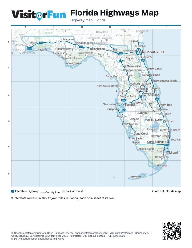
Road maps of Florida
16 road maps: each Interstate and byway on a sheet of its own.
- I-4 in Florida
- I-10 in Florida
- I-75 in Florida
- I-95 in Florida
- I-110 in Florida
- I-195 in Florida
- I-275 in Florida
- I-295 in Florida
- I-595 in Florida
- A1A Scenic & Historic Coastal Byway
- Big Bend Scenic Byway
- Florida Black Bear Scenic Byway
- Florida Keys Scenic Highway
- Indian River Lagoon National Scenic Highway
- Ormond Scenic Loop & Trail
- River of Lakes Heritage Corridor
Highway index of Florida
Each highway on the sheet and the grid squares it crosses.
- I-4D3, E2, E3
- I-10A1, B1, C1, D1, E1
- I-75D1, D2, D4, E2, E3, E4, E5, F5
- I-95E1, E2, E3, F3, F4, F5
- I-110A1
- I-175D4
- I-195F5
- I-275D3, D4, E3
- I-295E1
- I-375D4
- I-395F5
- I-595F5
- US 1E1, F5
- US 17E1, E3
- US 19D3, D4
- US 92E3
- US 192E3
- US 301E2
- SR 9BE1, E2
- SR 13E1
- SR 23E1, E2
- SR 60D3
- SR 112F5
- SR 113E1
- SR 115E1
- SR 202E1
- SR 228E1
- SR 293B1
- SR 400E2
- SR 401F3
- SR 404F3
- SR 407F3
- SR 408E3
- SR 414E3
- SR 417E3
- SR 429E3
- SR 451E3
- SR 453E3
- SR 528E3, F3
- SR 536E3
- SR 538E3
- SR 568D3
- SR 570E3
- SR 589D3
- SR 616D3
- SR 618D3, E3
- SR 681D4
- SR 686AD3
- SR 690D3
- SR 694D3
- SR 826F5
- SR 836F5
- SR 856F5
- SR 869F5
- SR 874F5
- SR 878F5
- SR 887F5
- SR 924F5
Places on the map
- Apalachicola
- Arcadia
- Bayonet Point
- Blountstown
- Boca Raton
- Boynton Beach
- Callahan
- Cape Coral
- Cedar Key
- Chattahoochee
- Clearwater
- Clewiston
- Coral Springs
- Crawfordville
- Daytona Beach
- Doral
- Fort Pierce
- Fruit Cove
- Gainesville
- Gulfport
- Hilliard
- Homestead
- Homosassa Springs
- Immokalee
- Jacksonville
- Key Largo
- Key West
- Leesburg
- Live Oak
- Macclenny
- Marco Island
- Marianna
- Miami
- Milton
- Naples
- Navarre
- New Smyrna Beach
- Ocala
- Orlando
- Palm Bay
- Palm Coast
- Panama City
- Perry
- Pine Hills
- Pomona Park
- Port Charlotte
- Port St. Lucie
- Sanford
- Sarasota
- Sebastian
- Sebring
- Spring Hill
- Starke
- Stuart
- Tallahassee
- Tampa
- Titusville
- West Palm Beach
- Wewahitchka
- Winter Haven
© OpenStreetMap contributors, Open Database License, openstreetmap.org/copyright · Map data: Protomaps · Boundary: U.S. Census Bureau, Cartographic Boundary Files 2024 · Interstates: U.S. Census Bureau, TIGER/Line 2026















