

Florida map
Greenacres map
About 45,197 people live here (Census Bureau, 2024 estimate). The sheet's index lists 300 streets; Jog Road, 57th Avenue and Haverhill Road cross the most grid squares. Also on it: Cholee Lake Elementary School, Diamond View Elementary School and Greenacres City Hall.
Open the map (PDF, US Letter)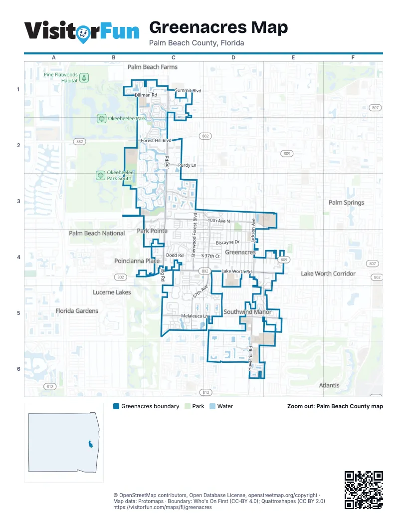
Street index of Greenacres
Each street on the sheet and the grid squares it crosses.
- Lake Worth RoadC4, D4, E4
- South Military TrailE4, E5
- Jog RoadC1, C2, C3, C4, C5
- Forest Hill BoulevardB2, C2
- Haverhill RoadD3, D4, D5, D6
- Sherwood Forest BoulevardC3, C4, C5
- 10th Avenue NorthC3, D3, E3
- Melaleuca LaneC5, D5, E5
- 57th AvenueC3, D3, D4, C5, D5
- Cresthaven BoulevardC3
- Spring Meadow DriveC1
- South 57th AvenueD3, D4
- Pinehurst DriveB2, B3
- Summit BoulevardC1
- Bowman RoadE4
- Purdy LaneC2
- Haverhill Road SouthD3
- River Bridge BoulevardC2, B3, C3
- Olive Tree BoulevardC1, C2
- Nautica Lakes BoulevardD6
- Pine Glen LaneC5
- Biscayne DriveC4, D4
- Jackson AvenueD3, D4
- Broward AvenueD3, D4
- Swain BoulevardD3, D4
- Jog Park DriveC3, C4
- Jennings AvenueD3, D4
- Fleming AvenueD3, D4
- Walker AvenueD3, D4
- Perry AvenueD3, D4
- Empire WayE4, D5, E5
- Woodlake BoulevardC4
- Martin AvenueD3, D4
- Dillman RoadB1, C1
- Summer Sky LaneC5
- Waterway Village CourtC3
- Foxtail DriveC2, C3
- Hatteras CircleC1, C2
- Lake Pine CircleC5
- Osage CircleB1
- Gladiator CircleD5, E5
- Pine CircleC5
- Parkside Green DriveC1
- Maplewood DriveC1
- Fairway CircleC2
- Perimeter DriveC3, C4
- Pine Hov CircleD5
- Nautica Lake CircleD6
- Sawgrass CircleC2
- Clinton BoulevardD4
- White Pine CircleC2
- Wry RoadC4
- Timberlane CircleC5
- Caribe CourtB3, C3
- Lakemont CircleC4
- Constitution WayC3
- Salmon IsleC1
- Knotty Pine CircleD5
- Olympic CircleB1, C1, C2
- Egret Lake DriveC3
- Red Cedar CircleC3
- 2nd StreetD4
- 1st StreetD4
- Tall Cypress CircleC4
- Olivewood CircleC3
- South 38th CourtC4, D4
- South 37th CourtC4, D4
- Meadow Lake DriveC2
- Silver Buttonwood DriveC3, C4
- Dubbin Drive WestC5
- Seminole Palms DriveC4
- Pointe CircleB3, C3
- Seven Springs BoulevardC3
- 4th StreetD4
- Shadow Wood DriveC3, C4
- Canal 14 RoadD5, E5
- South 37th StreetC4, D4
- Pine Ridge CircleD4
- Olive Tree CircleB2, C2
- Island Manor DriveC2
- Island Shores DriveC3
- Poolside DriveC3, D3
- Pinewood Lake CourtC1, C2
- Starblaze DriveD5
- Lisa LaneD4, D5
- Landings BoulevardB2, C2
- Woodlake CircleC4
- Harbor Lake CircleC2, C3
- Northern Lights DriveD6
- Dodd RoadC4
- Bayview RoadC3, C4, C5
- Arbor Lakes RoadB2, C2, C3
- Dubbin DriveC5, D5
- Rainbow DriveC5
- Centurian CircleE4, E5
- Grand Banks BoulevardD6
- Grandiflora DriveC3
- Queenship CourtD6
- Colonial BoulevardC4, C5
- South 55th AvenueD4
- Lancaster DriveD3, D4
- Island WayB2, C2
- Waters Edge CircleB3, C3
- Avion CircleD5
- Raulerson DriveE4
- Woodfield RoadC1
- South 38th StreetC4, D4
- Cove RoadB3, C3
- Egret CircleC3
- Oak Terrace DriveC5
- Chariot CircleE5
- Ramblewood CircleC4
- Nottingham CircleC4
- Eagle Ridge DriveB3
- Ranchette RoadC1
- Crosswinds DriveC2
- Foxtail Palm CourtD6
- Sunny Pine WayC3
- Cambridge StreetD4
- Lucerne Park DriveC3, C4
- Suncrest RoadC4
- Sea Pine WayC3
- South Dorchester DriveC3, D3, C4, D4
- Nicia WayD5, E5
- Mil-Lake CircleE4
- Stonecreek StreetC1
- Rising Comet LaneD5, D6
- Cohune Palm CourtD6
- Elsinore CircleC4
- Two Pine DriveB2
- Hammocks TrailB3, C3
- Macarthur Palm TrailD6
- Biscayne BoulevardC4
- Pine AvenueC5
- Harbour Pointe WayC2
- Silver Moon LaneC5
- Cleary RoadB1
- Eastbay DriveD6
- La Pinata BoulevardC4, D4
- Aurora Lakes CircleD5
- Albin DriveD5, D6
- Rainbow CircleC5
- Island Gypsy DriveD6
- Pine Hollow CircleD4, D5
- Dans PlaceC4
- Canterbury DriveC3
- Wedgewood CircleC4
- Hammocks CourtC2
- Mill Brook Way CircleC4
- South 35th CourtD4
- Camden DriveC3, D3
- Canalake BoulevardD3
- Appian WayE5
- Harmony DriveC4
- Marco CourtC5
- Southview AvenueD4
- Baldwin BoulevardD5
- Caesar CircleD4, D5
- Greenwich DriveD3
- Sky Pine WayC3
- Wishing Star LaneD5, D6
- Hammocks DriveC2
- Nash TrailD6
- Santa Catalina PlaceC3
- Baja TerraceD5
- Constantine CircleD5
- Coquina Winds WayE4
- Malibu CircleC1
- Centurian WayD5, E5
- Misty Pines TrailD5
- Sabreline TerraceD6
- Soundings CourtB2, C2
- Westminster DriveC4
- Toga WayD5, E5
- Gardner LaneE5
- Crooked Stick WayC2
- Wellcraft DriveD6
- Shady Pine WayC3
- Channel DriveC3, D3
- East Pickwick Park DriveD3
- South 56th TerraceD4
- Bulrush CourtB1
- Moon Shadow LaneD5, D6
- 56th Terrace SouthD5
- West Pickwick Park DriveD3
- Pine CourtC5
- South 36th StreetD4
- Fire Sky DriveC5
- Shadow Creek RoadC2
- La Paseos DriveC4, D4
- Rosewood LaneC4
- Chickasaw RoadC4
- Sunseeker BoulevardD6
- Private PlaceC3
- Whispering Pine WayC4, D4
- Sealine BoulevardD6
- Cape Cod TerraceC1
- Pond Tree CourtC4
- Silver Ridge LaneC1
- Solar Point DriveD6
- Dockside CircleC3
- Fairfield CircleC4
- 13th Road SouthC1
- Chickasaw CircleC4
- Red Pine LaneC2
- Riverside DriveD3
- Pier DriveD3
- Canalside DriveD3
- Knotty Pine BoulevardD5
- Hov BoulevardD5
- North Dorchester DriveC3, D3
- Mainship DriveD5, D6
- Nyack LaneE4
- Leland LaneD5
- Wedgewood Lakes SouthC4
- Windmill Palm WayD6
- La Mar CourtC4
- 66th TerraceC1
- Keystone WayC4, D4, C5
- Harwich CourtC4
- Polaris CoveD6
- Suntree CourtC1
- Bright Galaxy LaneD6
- Landings RunC1
- Lazy Pine WayC4
- 52nd Drive SouthD4
- North Eric CircleC4
- Pine Needle DriveD4
- Dahl DriveD4
- Heather Drive WestC4
- Inlet WayC1
- North Stuart CircleC4
- Caranday Palm DriveD6
- Annette CourtC1
- Heather Drive EastC4
- South Stuart CircleC4
- 30th LaneC5
- Wharf LaneD3
- Seaside DriveD3
- South Eric CircleC4
- Peachtree LaneC4
- Sunland CourtC5
- Cape May LaneC1, C2
- Trail EndB2, B3
- Monteray WayC1
- Baycourt IsleC1
- Newstead CourtC4
- Shoreview DriveD3
- Trotters LaneB2, B3
- Ambertree LaneC3
- Patrick WayC2
- Monmouth RoadB1
- Rome CourtE4
- Wedgewood Lake NorthC4
- Blue Baneberry LaneC3
- Egret Nest LaneC3
- Friendship LaneC4
- Baywood LaneC3
- Canal 10 RoadE3
- American Azalea LaneC3
- Glentree LaneC4
- Mil-Lake CourtE4
- Bamboo Palm CourtD6
- Mil-Pond CourtE4
- Mil-Stream CourtE4
- Cypress CourtC5
- Mil-Race CourtE4
- Mil-Run CourtD4
- Silk Dogwood LaneC4
- White Sable Palm LaneC4
- Emerald Sky LaneC5
- Piney CourtC5
- Woodwind CourtC5
- 48th LaneD5
- Corbett RoadD6
- Fishers PlaceC1
- Inlet CircleC3, D3
- Blue Moon DriveD5, D6
- Thompson WayD4
- 9th LaneD5
- Poinciana DriveB4
- Cording WayD4
- Da'liva TerraceC5
- Applewood DriveC4
- Paddock LaneC3
- Alexandria PlaceC4
- Eaton CourtD3
- Loblolly LaneD5
- Friendship CircleC4
- Willow LaneC5
- Treasure LaneC5
- Tall Pine WayD4
- 1st LaneC5, D5
- Doral DriveC2
- Red Top DriveB1
- Wellman TrailE5
- Pebble Beach LaneC2
- Dorchester Drive NorthD3
- Ridge Tree CourtC4
- Monte Fino CourtD6
Places on the map
- ALDI
- Autonation Chevrolet Greenacres
- Cholee Lake Elementary School
- Citgo
- CVS Pharmacy
- Diamond View Elementary School
- Evangelical Bible Seminary
- Fara Bender DMD PA
- Greenacres Bowl
- Greenacres Branch Library
- Greenacres City Hall
- Greenacres Elementary School
- Greenacres Freedom Park
- Greenacres Post Office
- Heritage Elementary School
- John I Leonard High School
- L.C. Swain Middle School
- Lake Worth 8
- Liberty Park Elementary School
- McDonald's
- Okeeheelee Middle School
- Olive Tree Park
- Paul's Motel
- Publix
- River Bridge park
- Samuel J. Ferreri Community Park
- Target
- Tradewinds Middle School
- Walmart Neighborhood Market
- Walmart Supercenter
Next to Greenacres
- Atlantis
- Covered Bridge
- Florida Gardens
- Lake Worth Corridor
- Lucerne Lakes
- Palm Beach Farms
- Palm Beach National
- Palm Springs map
- Poincianna Place
- The Fountains
© OpenStreetMap contributors, Open Database License, openstreetmap.org/copyright · Map data: Protomaps · Boundary: Who's On First (CC-BY 4.0); Quattroshapes (CC BY 2.0)















