

Florida map
Palm Springs map
About 28,548 people live here (Census Bureau, 2024 estimate). The sheet's index lists 217 streets; South Congress Avenue, Davis Road and Forest Hill Boulevard cross the most grid squares. Also on it: Lake Palmarlito, Forest Hill Center and Greenwood Shopping Center.
Open the map (PDF, US Letter)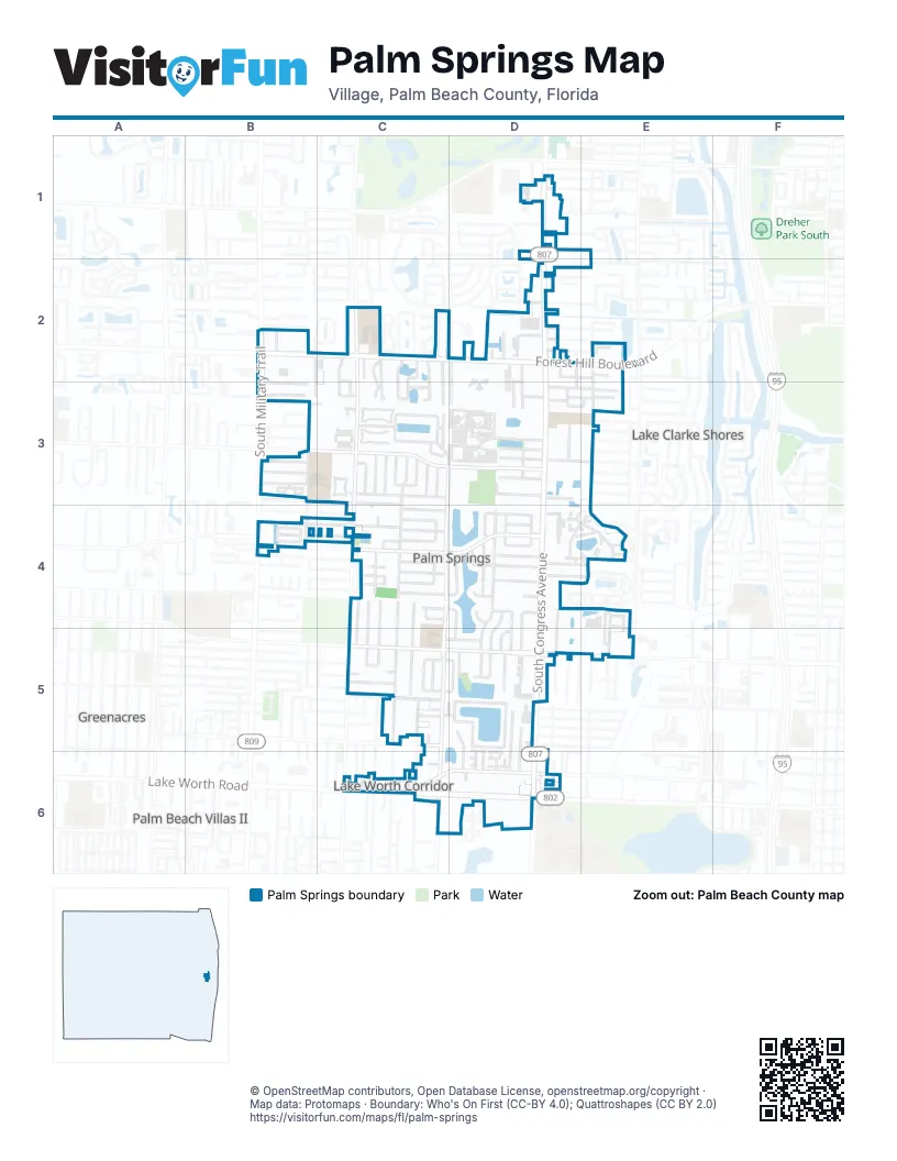
Street index of Palm Springs
Each street on the sheet and the grid squares it crosses.
- Collin DriveD1
- Flamango Lake DriveD1
- Holly RoadD1
- Marbill RoadD1
- Palmarita RoadD1
- South Congress AvenueD1, D2, D3, D4, D5, D6
- Burger Kind Drive-ThroughB2
- Erie TerraceB2
- Forest AvenueB2, B3
- Forest Hill BoulevardB2, C2, D2, E2
- Forest Lakes CircleB2
- South Military TrailB2, B3, B4
- Sunset Ranch RoadB2
- Taco Bell Drive-throughB2
- Anderson LaneC2, C3
- Bell LaneC2, C3
- Emilio LaneC2, C3
- Kirk RoadC2, C3, C4, C5
- Palm Acres DriveC2, C3
- Rich DriveC2, C3
- Richard LaneC2, C3
- Royal Forest CourtC2
- Sandra LaneC2, C3
- Shadetree WayC2, C3
- Sherri CircleC2, C3
- Sunset RoadC2
- Woodbridge Lakes CircleC2
- Woodhaven DriveC2
- Woods Bend RoadC2
- Alice AvenueD2, D3
- Angel DriveD2, D3
- Cherokee RoadD2
- Choctaw RoadD2
- Colonial Palms WayD2, D3
- Creek RoadD2
- Dalinda LaneD2
- Davis RoadD2, C3, D3, C4, C5, C6
- Easy StreetD2, D3
- Fairview Villas DriveD2, D3
- Lone Pine WayD2
- Melaleuca RoadD2
- Muskogee RoadD2, D3
- Oak DriveD2
- Riddle RoadD2
- Seminole RoadD2, E2
- Shawnee RoadD2, E2
- Tucker RoadD2, D3
- Florida Mango RoadE2, E5
- Nelson DriveE2
- Prairie RoadE2, E3
- Anna LaneB3
- Barbridge RoadB3
- Canal 9 RoadB3, C3
- Cypress East WayB3
- Cypress LaneB3, C3, D3
- Cypress WayB3
- Donald RoadB3, B4
- Forest LaneB3
- Line DriveB3
- Madrid DriveB3, C3
- Purdy LaneB3, C3
- Alemeda DriveC3, D3
- Canal 8 RoadC3
- Fontana DriveC3
- Gulfstream RoadC3, C4, C5, C6
- Inglewood DriveC3
- Los Altos RoadC3
- Maria Theresa AvenueC3
- North Palm Villas WayC3
- Palo Alto DriveC3
- Paris DriveC3
- Rome DriveC3
- San Fernando DriveC3
- San Mateo DriveC3
- Santa Anna DriveC3
- South Palm Villas WayC3
- Springdale BoulevardC3
- Springdale CircleC3
- Springdale CourtC3, D3
- Vienna DriveC3
- Village Green CircleC3
- Village Green Circle EastC3
- Village Green Circle SouthC3
- Village Green Circle WestC3
- Village Green CourtC3
- Woodland RoadC3
- Apalachee RoadD3, E3
- Bard StreetD3, E3
- Bermuda RoadD3
- Bonnie BoulevardD3
- Bonnie Villas BoulevardD3
- Byron StreetD3
- Dickinson CourtD3
- Dobrow RoadD3
- Dolan RoadD3
- Dolphin CircleD3, E3
- Drew WayD3
- Floweva RoadD3, E3
- Frost RoadD3
- Lark RoadD3
- Laura LaneD3
- Lillian RoadD3
- Lori DriveD3
- Meadow RoadD3
- Sylvia LaneD3
- Thelma RoadD3
- Troubadour StreetD3, E3
- Post StreetE3
- Prairie Key RoadE3
- Prairie LaneE3
- Cresthaven BoulevardB4
- Dale RoadB4, C4
- Hillary CircleB4
- Kent AvenueB4, C4
- Linda LaneB4, C4
- Park LaneB4, C4
- Rachael WayB4
- 38th TerraceC4
- Bayside RoadC4
- Cavalier RoadC4
- East Lake RoadC4
- Elizabeth Place SouthC4
- Espan CourtC4
- Evans DriveC4, C5
- Ford RoadC4, C5
- Greenbrier DriveC4, D4
- Masters RoadC4
- Mid Pines RoadC4
- Pinehurst RoadC4
- Ponte Vedra RoadC4
- Reo LaneC4, C5
- Riverdale RoadC4
- Rostan LaneC4, C5
- San Martin CourtC4
- Sardina DriveC4
- Sardina LaneC4
- Shady Lane RoadC4
- Tamoshanter DriveC4, D4
- Winged Foot RoadC4
- Yucatan DriveC4, D4, D5
- Abaco DriveD4, D5
- Ainsworth CircleD4
- Alice DriveD4, E4
- Arabian RoadD4, E4
- Carol AvenueD4
- Cayman DriveD4, D5
- Emerson AvenueD4
- Emerson CircleD4
- Granada CourtD4
- Granada DriveD4, D5
- Henthorne DriveD4, D5
- Keller DriveD4
- Lake Arbor DriveD4, E4
- Lanier DriveD4
- Longfellow DriveD4
- Lorene DriveD4, E4
- Osborne DriveD4
- Poe DriveD4
- Rex AvenueD4
- Rex CourtD4
- Riley AvenueD4
- Summer StreetD4, D5
- Boundbrook BoulevardE4
- Boundbrook Drive SouthE4
- Hayden DriveE4, E5
- Palm DriveE4, E5
- Springfield LaneE4, E5
- 10th Avenue NorthC5, D5, E5
- 7th Avenue NorthC5
- Andros RoadC5, D5
- Barbados DriveC5
- Belle RoadC5
- Canal RoadC5
- Coconut RoadC5, C6
- Fern StreetC5
- Hunt RoadC5
- Jamaica DriveC5
- Lakewood RoadC5
- Mercurio DriveC5
- Morgans WayC5
- Pleasant PlaceC5
- Russell DriveC5, D5
- Ruth RoadC5
- Sally LaneC5
- Sierra DriveC5
- Talia CircleC5, D5
- Tortuga RoadC5
- Tropical WayC5
- Waterview DriveC5, D5
- Elizabeth StreetD5, D6
- Hi StreetD5
- Manor DriveD5
- Miller RoadD5, D6
- Riedel AvenueD5, D6
- Sago Park RoadD5
- San Juan DriveD5
- Waterview CircleD5
- Lynnwood DriveE5
- 2nd Avenue NorthC6, D6
- Adcock LaneC6
- Corrigan CourtC6
- Edwards AvenueC6
- Foss RoadC6
- Lake Worth RoadC6, D6
- Montante BoulevardC6
- Serubi AvenueC6
- Amanda StreetD6
- Bellevue AvenueD6
- Foxridge CourtD6
- Harrington CourtD6
- Hemingway CourtD6
- Mar-Mak DriveD6
- Parkside CircleD6
- Pond PlaceD6
- Tiffany CourtD6
- Vanessa StreetD6
- Woodridge TerraceD6
Places on the map
- 7-Eleven
- A New Dimention Tattoo Inc.
- Advance Auto Parts
- ALDI
- Artisan Furniture & Finds
- Bernardi Fountains
- Boston Market
- Burger King
- Chili's
- D'Lopez Cigars
- Forest Hill Center
- Fortune Cookie Oriental Supermarket
- Frost Lake Park
- G-Star School Of The Arts
- Greenwood Shopping Center
- Kirklane Elementary School
- Lake Palmarlito
- Lake Sago
- Lake Waterview
- Lake Worth Corridor
- Lake Worth Drive-In
- Lakeshore Plaza
- Library Cooperative of the Palm Beaches Palm Springs Public Library
- Off Lease Only
- Oxygen Development
- Palm Springs Middle School
- Palm Springs Village Center Complex
- Paws 2 Help
- Phantom Fireworks
- Presidente Supermarket #38
- Publix
- RaceTrac
- Sago Palm Park
- Shores Shopping Center
- Walgreens
- Walmart Neighborhood Market
- Walmart Supercenter
- Water's Edge Dermatology
- Wawa
- Wells Fargo
Next to Palm Springs
- Greenacres map
- Lake Clarke Shores
- Palm Beach Villas II
© OpenStreetMap contributors, Open Database License, openstreetmap.org/copyright · Map data: Protomaps · Boundary: Who's On First (CC-BY 4.0); Quattroshapes (CC BY 2.0)















