

Florida map
Hendry County map
About 46,130 people live here (Census Bureau, 2024 estimate). The sheet's index lists 300 streets; Sam Jones Trail, Evercane Road and 13th Street cross the most grid squares. Things to do inside the boundary: Ah-Tah-Thi-Ki Museum.
Open the map (PDF, US Letter)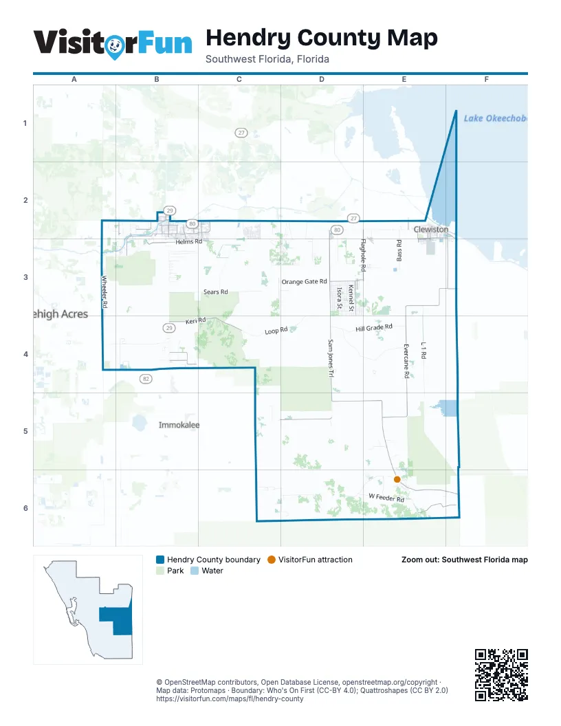
Street index of Hendry County
Each street on the sheet and the grid squares it crosses.
- Sugarland HighwayE2
- Hickpochee AvenueB2
- South Main StreetB2
- West Hickpochee AvenueB2
- North Bridge StreetB2
- West State Road 80B2
- Sam Jones TrailD2, D3, D4, D5, E5
- Evercane RoadF2, E3, F3, E4, E5
- Josie Billie HighwayE5, E6, F6
- North River RoadB2, A3
- Immokalee ExchangeC5, D5
- Clewiston ExchangeD5
- South Devil's Garden RoadD3
- North Devil's Garden RoadD3
- Nobles RoadB2
- South Bridge StreetB2
- Thigpen RoadB2
- Keri RoadB4, C4
- East Cowboy WayB2, C2
- Flaghole RoadE2, E3
- Fort Denaud RoadB2, B3
- Helms Road WestB3
- BIA Highway 1283E6, F6
- Helms RoadB3, C3
- North Felda Loop RoadB4
- Pine Cone AvenueD3
- Birchwood ParkwayB2
- Collingswood ParkwayB2, B3
- Cedarwood ParkwayC2, C3
- South Felda Loop RoadB4
- South Cabbage Palm StreetD3
- North Cabbage Palm StreetD3
- Old State Road 80E2, F2
- Kirby Thompson RoadB2
- County Road 720E2
- Georgia AvenueE2
- West Cowboy WayB2
- South WC Owen AvenueE2, E3
- The Palms StreetD3
- Davidson RoadE2, F2
- Lewis BoulevardE2
- West Ventura AvenueE2
- Rogers RoadF3
- City Ditch RoadB2
- Dr Martin Luther King BoulevardB2
- Woodland BoulevardD3, E3
- Harlem Academy AvenueE3
- Sonora AvenueE2
- South Olympia StreetE2
- East Ventura AvenueE2
- 13th StreetE2, C3, D3, E3
- Francisco StreetE2
- Whidden RoadB2
- Ford RoadB2, B3
- 7th StreetE2, D3, E3
- South Francisco StreetE2
- Fort Denaud BridgewayB2
- Olympia StreetE2
- Kirby RoadB2
- Cowboy WayC2
- Sears RoadB3, C3
- L 1 RoadE3, E4, E5
- Dooley Grade RoadD4, E4
- Hill Grade RoadD4, E4
- Felda Church RoadB4
- Loop RoadC4, D4
- West Boundry RoadD6, E6
- Wheeler RoadA3, A4
- West Feeder RoadD6, E6
- Orange Gate RoadC3, D3
- Everhigh Acres RoadD2, D3
- Hendry Isles BoulevardD2, D3
- Schultz GradeD6
- Bass RoadE2, E3
- Herbert Hoover DikeE2, F2
- Wild Cow GradeC4
- Collins Slough RoadC3, C4
- Twin Mills GradeC3, C4
- Tri Britton Grade RoadC3, D3, C4
- Hunting Club AvenueD3, E3
- E1 Canal Maintenance RoadE6, F6
- Appaloosa AvenueD3, E3
- Horse Club AvenueD3
- Bald Cypress AvenueD3
- Evans RoadB3
- Al Don Farming RoadC2
- Wainwright RoadC6, D6
- Case RoadB3
- Northeast Eucalyptus BoulevardB2, B3
- South Felda Church RoadB4
- Montura AvenueD3
- Avenida del SurD3
- Perimeter RoadD3, E3
- Wellington ParkwayC2, C3
- McDaniels Ranch RoadE5
- Hilliard Grove RoadC3, D3
- BIA Highway 1299E6
- Willis Ranch RoadB4
- Christopher LaneC3
- Southland DriveD3
- Dump RoadD6
- Witt RoadD2, D3
- North Romero StreetD3
- Lexington ParkwayC2, C3
- Corbitt RoadC5
- L-28 InterceptorE6
- Hookers Point RoadE2, F2, E3, F3
- Kinser Grove RoadA2, B2
- Sycamore RoadC2
- North Hacienda StreetD3
- South Mayoral StreetD3
- North Datil StreetD3
- North Mayoral StreetD3
- South Quebrada StreetD3
- South Hacienda StreetD3
- South Kennel StreetD3
- North Quebrada StreetD3
- North Kennel StreetD3
- Doctors Hammock RoadD6
- Camino Real BoulevardD3
- 16th Canal RoadC3
- Surrency RoadE3
- West Alverdez AvenueE2
- Williams RoadB2, B3
- A RoadB3
- North Coral StreetD3
- South Sendero StreetD3
- North Granja StreetD3
- South Olivo StreetD3
- North Jinete StreetD3
- South Trebol StreetD3
- North Trebol StreetD3
- North Lindero StreetD3
- North Verda StreetD3
- Primrose BoulevardC2
- South Isora StreetD3
- Singletary CircleC6
- Brazil CircleB2, B3, C3
- Vero AvenueC3, D3
- Riviera AvenueC3, D3
- North Isora StreetD3
- Murray RoadB2, B3
- East Avenida del RioE2
- North Brida StreetD3
- Panama AvenueC3, D3
- North Palomino StreetD3
- North Arboleda StreetD3
- North Utopia StreetD3
- North Nogal StreetD3
- North Fronda StreetD3
- North Estribo StreetD3
- South Jinete StreetD3
- North Zambra StreetD3
- Mustang GradeC4
- Unnamed Road CourseE4
- Ponce de Leon AvenueE2
- Cypress Hammock CircleE6
- Tampa AvenueC3, D3
- South Datil StreetD3
- South Coral StreetD3
- South Fronda StreetD3
- Arcadia AvenueC3, D3
- North Olivo StreetD3
- South Lindero StreetD3
- South Romero StreetD3
- South Nogal StreetD3
- South Utopia StreetD3
- North Sendero StreetD3
- Southeast Banyan BoulevardC2
- Seminole AvenueB2, E2
- Heritage RoadB4
- South Arboleda StreetD3
- Lakeview AvenueC3, D3
- Southwest Raintree BoulevardB2, C2, B3, C3
- Plantation DriveC2
- South Brida StreetD3
- East Carnation DriveC2, C3
- B RoadB3
- West Avenida del RioE2
- Oak Haven DriveB2
- South Granja StreetD3
- South Estribo StreetD3
- Garcia DriveE5
- Farmer RoadE6
- South Verda StreetD3
- South Zambra StreetD3
- Southeast Raintree BoulevardC2, C3
- Homestead AvenueC3, D3
- Bonneville StreetB2
- River Blossom LaneB3
- Cpi RoadA4, B4
- Mc Daniels RanchE5
- Taft BoulevardD3, E3
- 11th StreetE2, D3, E3
- George Billie RoadE6
- Road Private Alico FarmsD4
- Phillips RoadB3
- Crow's Nest RoadC5, D5
- Northwest Raintree BoulevardC2
- East Somerset DriveB2, C2
- East Alverdez AvenueE2
- 10th StreetE2, D3, E3
- Rte 1512E6
- Southwest Banyan BoulevardC2
- Peachtree CircleB2, B3
- Avenida del ClubD3
- Harlem Tenant CircleE3
- South Elm StreetB2
- Live Oak LaneB2
- Northwest Eucalyptus BoulevardB2
- Pioneer 10th StreetD3
- Wilson RoadB3
- Avenida del CentroD3
- Pioneer 23rd StreetC3
- Mississippi AvenueE3
- South Riverside StreetD3
- Etumakee WayE4
- Fort Adams AvenueB2
- Bryan AvenueB2
- Springview CircleB2
- Riverside StreetD3
- Barfield RoadC6, D6
- Pine LaneE3
- Fort Simmons AvenueB2
- TampaC3, D3
- Fort Keis AvenueB2
- Tradewinds CircleB2
- South Palm StreetD3
- South Live Oak StreetD3
- South Palomino StreetD3
- Oak Grove RoadB2
- South Orange StreetD3
- South Shetland StreetE3
- Central AvenueE2
- Mims RoadB4
- South Jasmine StreetD3
- South Willow StreetD3
- Riverside RetreatA3, B3
- Northeast Raintree BoulevardB2, C2
- Herd Improvement RoadE6, F6
- 12th StreetE2, D3, E3
- BirchwoodB2, B3
- Silverfish DriveC2
- Center AvenueD3
- Morris Taylor RoadB4
- East Briarwood CircleB2
- Northeast Banyan BoulevardC2
- Citrus StreetB2
- West Aztec AvenueE2
- Broward AvenueB2
- Caloosa Estates DriveB2
- East Lincoln AvenueB2
- Cemetery RoadB2
- Billie Swamp Safari RoadE6
- West Almeria DriveC2
- East Fort Thompson AvenueB2
- G RoadB3
- Airglades BoulevardE2
- Detroit DriveB2
- Della Tobias AvenueE2, E3
- Carolina AvenueE3
- Neely Davis RoadB4
- E RoadB3
- Henry Osceola RoadE6
- F RoadB3
- Montana CircleB2
- Ivan BoulevardB2
- Kentucky AvenueE3
- Matthew LoopF3
- Trader RoadB2
- Hidden Hammock DriveB3
- East el Paso AvenueE2
- South Edgewater CircleB2
- Airport RoadE2, E3
- Justice CircleC2
- Southland RoadA2
- Riverbend DriveB2
- West Sagamore AvenueE2
- Southwest Eucalyptus BoulevardB2, B3
- Roberts Ranch RoadD5
- South Berner RoadE2
- West Carnation DriveC2, C3
- Aqua Isles BoulevardB2
- Virginia AvenueE3
- Beechwood CircleB2, B3
- Phoenix TerraceC2
- South Beechwood CircleB3
- Rainbow CircleB2
- East Paso Fino CircleD3
- Royal Palm AvenueE2
- Geraldine AvenueC2, C3
- Java AvenueD3
- Main StreetB2
- Pioneer 8th StreetD3
- East Aztec AvenueE2
- Sparkle DriveC2
- Wind Clan RoadE6
- East Sagamore AvenueE2
- West Briarwood RoadB2
- Northeast Tradewinds CircleB2
Things to do on the Hendry County map
Places on the map
- #8 Fairway
- Airglades Airport
- Big Cypress Airfield
- Big Cypress Mail Facility
- Bob Mason Park
- Bob Paul Airport
- C-43 Basin Storage Reservoir - Part 1
- Caloosahatchee Basin Water Storage Reservoir
- Central County Water Control District
- Charlton Strip
- Clewiston
- Clewiston Airport (historical)
- Clewiston Golf Course
- Clewiston High School
- Clewiston Middle School
- Clewiston Post Office
- Davis-Pratt Park
- Devils Garden Strip
- Dinner Island Ranch Wildlife Management Area
- Duda Airstrip
- Fort Denaud Cemetery
- Harlem
- Harlem Community Library
- Harper's Fly-In Ranch Airport
- Hendry Correctional Institution
- LaBelle
- LaBelle Municipal Airport
- Lazy Springs Recreation Park
- McDaniel Ranch Inc. Airport
- Montura Ranch Estates
- Okaloacoochee Slough State Forest
- Okaloacoochee Slough Wildlife Management Area
- Port La Belle
- Sic Island Loop
- Singletary Circle
- South Florida Water Management District
- Spirit of the Wild Wildlife Management Area
- Stormwater Treatment Area 5/6
- Unnamed Road Course
- Vitambi Springs
Next to Hendry County
- Immokalee
- Lehigh Acres
© OpenStreetMap contributors, Open Database License, openstreetmap.org/copyright · Map data: Protomaps · Boundary: Who's On First (CC-BY 4.0); Quattroshapes (CC BY 2.0)















