

Florida map
Key West map
About 25,240 people live here (Census Bureau, 2024 estimate). The sheet's index lists 300 streets; South Roosevelt Boulevard, North Roosevelt Boulevard and Flagler Avenue cross the most grid squares. Things to do inside the boundary: Conch Tour Train, Duval Street and Historic Tours of America.
Open the map (PDF, US Letter)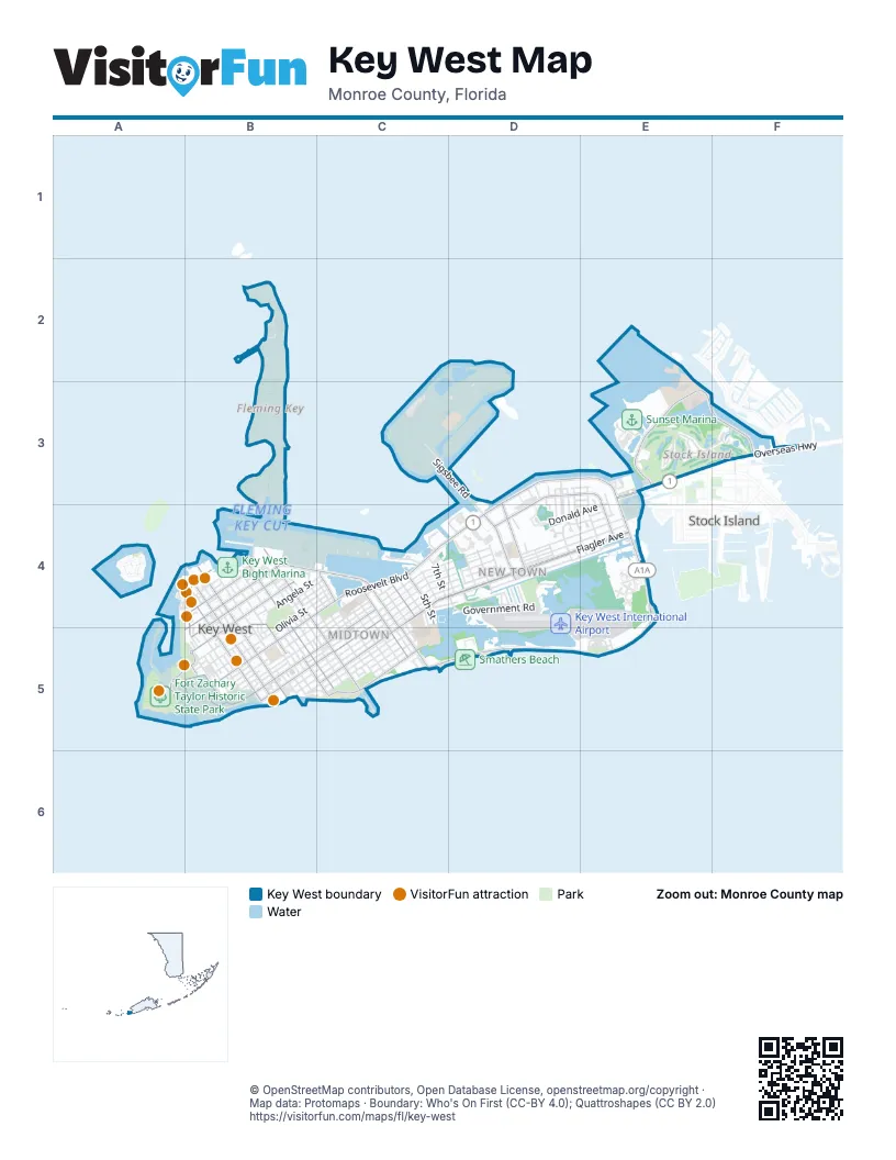
Street index of Key West
Each street on the sheet and the grid squares it crosses.
- North Roosevelt BoulevardD3, E3, C4, D4
- Overseas HighwayE3, F3
- Truman AvenueB4, C4, B5
- Whitehead StreetB4, B5
- Eaton StreetB4, A5, B5
- Garrison Bight CausewayC4
- Palm AvenueB4, C4
- Flagler AvenueC4, D4, E4, C5
- South Roosevelt BoulevardE3, E4, C5, D5, E5
- Kennedy DriveD4
- 1st StreetC4, C5
- Bertha StreetC5
- College RoadE3, F3
- United StreetC4, B5, C5
- White StreetB4, C5
- Simonton StreetB4, B5
- South StreetC4, B5, C5
- Duval StreetB4, B5
- Grinnell StreetB4, B5, C5
- Southard StreetB4, B5
- Fleming StreetB4, B5
- Atlantic BoulevardC5
- Northside DriveD3, E3, D4
- George StreetC4, C5
- Caroline StreetB4
- 14th StreetD3, D4
- Front StreetB4, B5
- 20th StreetE3, E4
- 5th StreetC4
- Windsor LaneB4, B5
- Reynolds StreetB5, C5
- Gardiner StreetA5, B5
- 3rd StreetF3, C4
- DeKalb AvenueB5
- Eisenhower DriveC4
- Quay RoadA5, B5
- Howard England WayA5
- Butler BoulevardB5
- Sands CircleB5
- Carey CircleA5
- Evans StreetB5
- Key Haven RoadF3
- MacDonald AvenueE3
- Sigsbee RoadD2, C3, D3, D4
- Catherine StreetC4, B5, C5
- Olivia StreetB4, C4, B5
- Government RoadD4
- Golf Club DriveE3, F3
- Staples AvenueC4, D4, C5
- Angela StreetB4, C4, B5
- Harris AvenueC4, D4
- Virginia StreetC4, B5
- Seidenberg AvenueC4, D4
- William StreetB4, B5
- Fogarty AvenueC4, D4
- Washington StreetC4, B5, C5
- Duck AvenueD4, E4
- Eagle AvenueD4, E4
- Patterson AvenueC4, D4
- Petronia StreetB4, C4, B5
- Elizabeth StreetB4, B5
- 17th StreetD3, D4
- VonPhister StreetB5, C5
- Seminary StreetC4, B5, C5
- Johnson StreetC5
- Donald AvenueE3, D4, E4
- Riviera DriveD4
- Margaret StreetB4, B5
- Peary CourtB4
- Amelia StreetB5
- Outer Mole RoadA5
- Thomas StreetB5
- Thompson StreetC4, C5
- Ashby StreetC4, C5
- Leon StreetC4, C5
- Frances StreetB4
- Georgia StreetB4, C4, C5
- North Gilmore DriveC3, D3
- Venetian DriveD4
- South Gilmore DriveC3, D3
- Ricketts CircleB4
- Florida StreetB4, C4, C5
- Emma StreetB5
- Duncan StreetC4, C5
- Laird StreetC5
- Sunset Key DriveA4
- 4th StreetC4
- Overlook DriveA4
- Arthur Sawyer RoadC3
- Pearl StreetB4, C4, C5
- 18th StreetD3, D4, E4
- Roosevelt BoulevardE4
- Mitscher DriveC4
- Trumbo RoadB4
- Louisa StreetB5
- 11th StreetD4
- 7th StreetC4
- Fort StreetB5
- Whiting AvenueB4
- 19th StreetE4
- Dunlap DriveD4, E4
- 17th TerraceD3, D4
- Fleming Key RoadB4
- Felton RoadC3, D3
- Sunset Marina RoadE3
- Halsey DriveC4
- Watson StreetB4, B5
- Packer StreetB4, B5
- Patricia StreetC5
- Rose StreetC5
- Pier D-2B4
- 2nd StreetC4
- Key Cove DriveD4
- Hilton Haven DriveC4
- Greene StreetB4
- 16th TerraceD3, D4
- 12th StreetD4
- Whalton StreetC5
- 10th StreetD4
- Seaside DriveE4
- Faraldo Circle - ArrivalsE5
- David Porter DriveD3
- Dewey RoadC3
- 6th StreetC4
- Julia StreetB5
- 8th StreetC4, D4
- Maine RoadD2
- Newton StreetB4, C4
- 18th TerraceE3, E4
- Pearl AvenueD4
- Harriet AvenueD4
- Sunrise DriveD4, E4
- Pine StreetB4, C4
- Ashe StreetB4
- Linda DriveC4, D4
- Varela StreetB4, B5, C5
- Casa Marina CourtC5
- Matthew Perry RoadD3
- Pier D-1B4
- Josephine StreetC5
- Pier D-3B4
- Tropical StreetC5
- Chevalier AvenueB4, C4
- Matthew RoadD2, D3
- Truxton RoadC3
- Eliza StreetC4, C5
- Seaside Court SouthE4
- Pryor CircleE3, E4
- Gulfview DriveC4
- Waddell AvenueB5, C5
- Airport BoulevardD4
- Douglas CircleE3, E4
- Royal StreetB5
- Kokenzie RoadE3
- Cindy AvenueE4
- Ely StreetB4
- Sunset DriveA4, D4
- Nancy Cherry LaneE5
- 20th TerraveE3, E4
- Spoonbill WayE3
- Ann StreetB4
- Seaside Court NorthE4
- Bahama StreetB4
- Elgin LaneB4
- James StreetB4
- Albury StreetB4, C4
- Venetia StreetC5
- Bahama DriveD4
- Dennis StreetC4, C5
- Porter LaneB5
- Alberta StreetB5
- Roosevelt DriveC4
- Terry LaneB5
- Center StreetB5
- Northside CourtD3, E3
- DeparturesE5
- Key PlazaD4
- Fort Taylor CircleB5
- Seminole StreetB5, C5
- Stephen Mallory RoadD3
- Steven AvenueC5
- Stickney LaneB4, E5
- Admirals LaneB4
- Henry CircleD4
- Jamaica DriveD4
- Patio RoadB5
- Welters WayA5
- Ellyson DriveC4
- SearstownD3
- Galveston LaneB4, B5
- Marquesa CourtD3, D4
- Toppino DriveD3
- F Moller DriveD3
- Blanche StreetC5
- Passover LaneB4
- Vivian StreetC4
- Paula AvenueE4
- Wall StreetB4
- Johnson LaneB5
- Thompson LaneB4, B5
- Zachary RoadB5
- 15th StreetD4
- 16th StreetD4
- Sunrise LaneE4
- Howe StreetB5
- Reordan CourtD4
- Gilmore DriveC3
- Kingfisher LaneE3, F3
- Pearlman CourtD4, E4
- Pearlman TerraceD3, E3
- Flagg AvenueC4
- Taxi LaneD4
- Vernon AvenueB5
- Flatley AvenueB4
- Rose LaneB4
- Glynn Archer Jiron StreetD4
- Peacon LaneB4
- Casa Roma OneE4
- Ellsberg CourtD4, E4
- Noah LaneB5
- Whisling Duck LaneF3
- Bowfin CourtC3
- Truman RoadB5
- Compass CourtB5
- Kestral WayE3
- Spalding CourtD4
- Trinidad Dr.D4
- Stump LaneB4
- Carsten LaneB4
- Telegraph LaneB4
- Curry LaneB4
- LKMC Parking Lot Roadway BE3
- Dey StreetB4
- Bard RoadC3
- Appelrouth LaneB4, B5
- Riviera LaneD4
- Duncombe StreetC4, C5
- Weech WayA5, B5
- Brunson CourtE4
- Trinity DriveD3
- Scholtz CourtD4
- 19th TerraceE3, E4
- Knowles LaneB5, C5
- Truesdell CourtD4
- 15th CourtD4
- Chapman LaneB5
- Shavers LaneB5
- Jose Marti DriveC4
- Whitmarsh LaneB5
- Samaritan LaneB5
- Seidenberg LaneC4
- Staples LaneC4
- Batfish CourtC3
- Covington AvenueB5
- Pohalski StreetB4
- McCoy CircleC4
- Peary Court RoadB4
- SailfishC3
- Havana LaneB4
- Poor House LaneB5
- Merganser LaneF3
- Chambers StreetC4
- Mickens LaneB5
- Love LaneB4
- Allen AvenueB5
- Sunset LaneA4, B4
- Sunshine AvenueC5
- Lang Milian AlleyB5
- Geraldine StreetB5
- Fitzpatrick StreetB4
- Sirugo AvenueC5
- Roberts LaneB4
- Atlantic DriveC5
- Go LaneE4
- Villa Mill AlleyB5
- Tannis AvenueC4
- Hoey RoadD4
- Sea Horse CourtC3
- AlleyD3
- Towers AvenueC4
- Pierce LaneB5
- Morgan CourtE4
- Sun TerraceD4
- Bakers LaneB4
- Aronovitz LaneB5
- Babcock AlleyB4
- Josephine Parker RoadB5
- Patone StreetB5
- Faraldo CircleE5
- Juanita LaneC4
- Calais LaneB5
- Nichols AvenueB4
- Nassau LaneB4
- Salmon CourtC3
- Carey LaneB4
- Sawyer AlleyB4
- Hibiscus LaneB4
- Canfield LaneB4
- Free School LaneB4
- Bay StreetC4
Things to do on the Key West map
Places on the map
- A & B Marina
- Bayview Park
- Branch Health Clinic Key West
- Commercial Ramp
- Conch Plaza
- Florida Keys Community College Library
- Fort Zachary Taylor Historic State Park
- GA Ramp
- Galleon Marina
- Gerald Adams Elementary School
- Hampton Inn
- Harvey Rest Beach Park
- Horace O'Bryant Middle School
- Hyatt Windward Pointe
- Ibis Bay Beach Resort
- Indigenous Park
- Key Plaza
- Key West Bight Marina
- Key West Cemetery
- Key West City Golf Club
- Key West High School
- Key West International Airport
- Key West Naval Station
- Key West Post Office
- Little Hamaca Park
- Lower Keys Medical Center
- Marriott
- Monroe County Detention Center
- Mount Trashmore
- Naval Air Station Key West Dredgers Key-Sigsbee
- Naval Air Station Key West Fleming Key Magazine
- Naval Air Station Key West Truman Annex
- Naval Air Station Key West Trumbo Point Annex
- NOAA - National Ocean Service
- Opal Key Resort & Marina
- Parrot Key Hotel & Resort
- Searstown Shopping Center
- Smathers Beach
- Sunset Marina
- The UPS Store
Next to Key West
- Stock Island
© OpenStreetMap contributors, Open Database License, openstreetmap.org/copyright · Map data: Protomaps · Boundary: Who's On First (CC-BY 4.0); Quattroshapes (CC BY 2.0)















