

Florida map
Monroe County map
About 80,908 people live here (Census Bureau, 2024 estimate). The sheet's index lists 300 streets; Overseas Highway, Palm Drive and Ocean Drive cross the most grid squares. Things to do inside the boundary: Bahia Honda State Park, Conch Tour Train and Dagny Johnson Key Largo Hammock Botanical State Park.
Open the map (PDF, US Letter)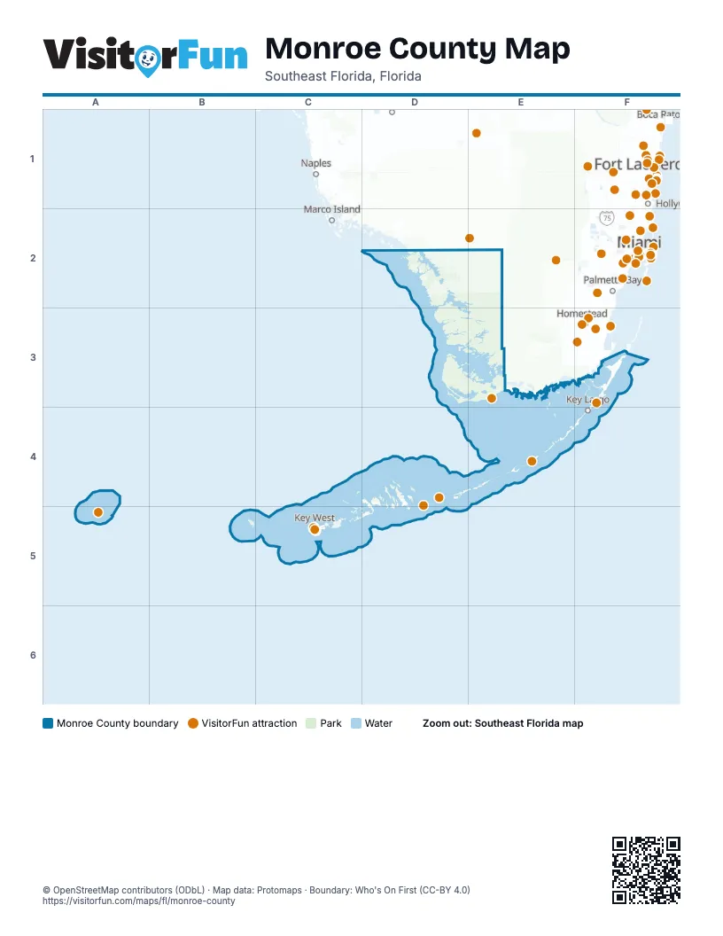
Street index of Monroe County
Each street on the sheet and the grid squares it crosses.
- Overseas HighwayF3, E4, F4, B5, C5, D5, E5, A6, B6
- Dixie HighwayF3
- New Seven Mile BridgeC5
- North Roosevelt BoulevardA6
- Truman AvenueA6
- Whitehead StreetA6
- Eaton StreetA6
- Palm AvenueE4, B5, A6
- Garrison Bight CausewayA6
- Main Park RoadD3, D4
- Card Sound RoadF3
- Flagler AvenueA6
- South Roosevelt BoulevardA6
- Flamingo Lodge HighwayD4
- 1st StreetE4, F4, B5, D5, A6
- Coral DriveF3, E4, F4, B6
- Kennedy DriveA6
- Bertha StreetA6
- Loop RoadC1, D1
- Boca Chica RoadA6
- Key Deer BoulevardB5
- Old State Road 4AB5, B6
- Old Overseas HighwayE4
- Old State Highway 4AE4
- Middle Torch RoadB5
- Crane BoulevardB5
- Blimp RoadB5
- Sugarloaf BoulevardB6
- Watson BoulevardB5
- South StreetB5, A6
- Sombrero Beach RoadC5
- Atlantic BoulevardF3, E4, F4, A6
- Ocean DriveF3, E4, F4, B5, D5, B6
- Watson RoadB5, C5
- Avenue BF4, B5, C5, A6
- College RoadA6
- 5th StreetB5, D5, A6
- United StreetA6
- State Road 4AB5
- Old HighwayE4
- 3rd StreetF4, B5, D5, A6
- Front StreetA6
- White StreetA6
- East Shore DriveF4, B5
- West Shore DriveB5
- 5th AvenueB5, A6
- Simonton StreetA6
- Bay DriveE4, B5, B6
- County RoadB5, D5, A6
- Duval StreetA6
- West Indies DriveB5
- Ocean Bay DriveE4
- Key Haven RoadA6
- Grinnell StreetA6
- 14th StreetB5, D5, A6
- Northside DriveB5, A6
- Southard StreetA6
- Wilder RoadB5
- George StreetF4, A6
- Fleming StreetA6
- Coral AvenueE4, B5
- Hibiscus DriveF4, B5
- Maloney AvenueA6
- Sands RoadB5
- Caroline StreetA6
- Drost DriveB5
- Cross StreetA6
- MacDonald AvenueA6
- 20th StreetA6
- Windsor LaneA6
- Mako AvenueB5
- Reynolds StreetA6
- Gardiner StreetA6
- 4th AvenueB5, A6
- Bessie RoadE4
- DeKalb AvenueA6
- Eisenhower DriveA6
- Quay RoadA6
- Trinidad RoadE4, B5
- Pattison DriveB5
- East Circle DriveB6
- Howard England WayA6
- Butler BoulevardA6
- Sands CircleA6
- Carey CircleA6
- Evans StreetA6
- Dorn RoadB5
- Midway AvenueA6
- Old US 1C5, E5
- Long Beach DriveC5, B6, C6
- Palm DriveF3, E4, F4, B5, D5, E5, A6, B6
- Avenue AF4, B5, C5, D5, A6
- 2nd StreetE4, F4, B5, D5, A6
- Anchor DriveF3
- Coco Plum DriveD5
- Sombrero BoulevardC5
- Aviation BoulevardC5
- Avenue CF4, B5, C5, D5, A6
- Rick TurnerC5
- Niles RoadB5
- Morton StreetD5
- Sigsbee RoadA6
- South Harbor DriveF3
- 4th StreetB5, D5, A6
- Catherine StreetE4, B5, A6
- Harbor DriveE4, F4, C5
- Avenue FF4, B5, D5, A6
- Sunrise DriveE4, B5, C5, A6
- Avenue DF4, B5, C5, D5, A6
- Riviera DriveE4, A6
- 6th StreetB5, D5, A6, B6
- Betty Rose DrA6
- Olivia StreetA6
- Barracuda LaneF3, C5
- Government RoadA6
- Avenue EF4, B5, C5, D5, A6
- Central AvenueE4, F4, B5
- Newfound BoulevardB5
- Sunrise Cay DriveF3
- Burton DriveE4
- Sunset Cay RoadF3
- Valencia RoadF4, B5
- Flamingo RoadF3, D4, B5
- Golf Club DriveA6
- Buttonwood DriveE4, F4, B5, B6
- Jolly Roger DriveE4, B5
- Staples AvenueA6
- Spanish Main DriveB5
- Cannon Royal DriveA6
- Avenue GB5, D5, A6
- Indies RoadB5, B6
- Angela StreetA6
- Caribbean Drive EastB5
- Harris AvenueA6
- Pirates RoadB5
- Sunset DriveE4, C5, E5, A6
- 17th StreetB5, A6
- Virginia StreetA6
- Washington StreetC5, A6
- Seidenberg AvenueA6
- Tamarind RoadF4, B6
- Ocean Reef DriveF3
- Mm 56.1 Burn PointD5
- William StreetA6
- 12th StreetB5, D5, A6
- Sunset BoulevardE4, F4, C5, B6
- Fogarty AvenueA6
- Stirrup Key BoulevardC5
- Koehns AvenueB5
- Independence AvenueB5, A6
- Duck AvenueA6
- Eagle AvenueA6
- Patterson AvenueA6
- 11th StreetD5, A6
- Fern AvenueB5
- Hibiscus LaneF4, B5, A6, B6
- 7th StreetD5, A6, B6
- Barracuda BoulevardF4, D5
- Petronia StreetA6
- Caribbean DriveF4, B5
- Gatehouse RoadF3
- Matthews RoadB5
- Beach RoadF3, E4, F4
- Saratoga AvenueB5, A6
- Forrestal AvenueB5, A6
- Venetian DriveE5, A6
- Coral WayF3, E4, B5, A6
- South Airport RoadE4
- Shaw DriveF4
- Date Palm DriveB5
- Pine AvenueE4, B5
- Gulfview DriveE5, A6
- La Paloma RoadF4
- Indies Drive SouthD5
- Kyle BoulevardB5
- 10th StreetD5, A6
- Bay RoadF4, A6
- Ocean TerraceE4, C5
- Sea LaneB5, E5, A6
- 19th StreetB5, C5, A6
- Park DriveF4, A6
- Sunset RoadE4, B5
- Venetian BoulevardE4
- Margaret StreetB5, A6
- Sound DriveF4
- Peremiter RoadF3
- Elizabeth StreetA6
- Sawyer DriveB5
- Calle EnsuenoC5
- Snapper LaneF3, E4, B5, C5, B6
- Gulfstream BoulevardC5
- Old US Hwy 1E5
- Canal StreetE4, F4, B5
- Largo RoadF3
- West Seaview DriveD5
- Coral LaneF3, D5
- South Coconut Palm BoulevardE4
- East Seaview DriveD5
- Avenue IB5, D5
- VonPhister StreetA6
- Seminary StreetA6
- 8th StreetD5, A6
- Johnson StreetA6
- Avenue HB5, D5
- Donald AvenueA6
- 1st AvenueF3, E4, B5, D5, A6
- Mahogany LaneF3, B5
- Canal DriveF4, B5
- Oleander DriveE4, B5
- Gulf BoulevardB5
- Indian Mound TrailE4
- Pippin DriveE4
- Barry AvenueB5
- Bay Shore DriveB5
- 2nd AvenueE4, B5, A6
- Bayview DriveE4, B5, D5, E5
- Osprey LaneF3, B5, A6
- Crown Point HarborC5
- Plantation BoulevardE4
- North DriveF3, E4
- Spain RoadB5
- Peary CourtA6
- 18th StreetB5, A6
- Pearl AvenueE4, A6
- Palmetto AvenueE4, B5
- Sandy CircleB5
- Shrimp RoadA6
- Dolphin RoadF4, B5, A6
- Cinnamon Bark LaneF3
- La Fitte RoadB5
- Blackbeard RoadB5
- Coconut DriveE4, F4, A6
- Marina AvenueE4, F4
- Mutiny PlaceE4
- Island DriveF3, F4
- Louisa StreetC5, A6
- Atlantic DriveF3, F4, A6
- Johnson RoadB5
- North Bounty LaneE4
- Ocean Shores DriveE4, F4
- Coastal DriveE4
- Mockingbird RoadF3, E4
- West Snapper Pt DriveF3
- Bimini DriveD5
- Amelia StreetA6
- Laguna AvenueE4, F4
- Outer Mole RoadA6
- Marina DriveF3
- Bahama AvenueE4, F4
- Beach DriveB5, C5, A6, B6
- Caloosa StreetE4, B5
- Big Pine AvenueB5
- North Blackwater LaneF3
- Thomas StreetA6
- Bay Ridge RoadF3
- Grand StreetE4, B5
- Manor LaneC5
- Gulf Shore BoulevardD5
- Thompson StreetA6
- Ashby StreetA6
- Gulf of Mexico BoulevardD5
- Gardenia StreetE4
- Colson Boyd DriveF4
- Shangri-la AvenueA6
- Dolphin DriveC5, D5
- Leon StreetA6
- Airport Drive SouthB5
- Frances StreetA6
- Palmetto DriveB5, A6
- Bat Tower RoadB5, B6
- Venetian WayE4, B6
- South Point DriveB6
- Narcissus AvenueB5
- Stave GulfD5
- 1st Avenue GulfD5
- Georgia StreetA6
- 3rd AvenueB5, A6
- Katherine StreetB5
- Langley AvenueA6
- Bahama Drive SouthD5
- North Gilmore DriveA6
- Egret LaneF4, B5, A6
- Jamaica LaneB5, B6
- Tarpon LaneF3, B5
- Coconut RowE4, A6
- Sea Anchor CircleE4
- South Andros RoadF3
- Tequesta StreetE4, B5
- Hibiscus StreetE4, B5
- Valois BoulevardF3
- Seagate BoulevardE4, F4
- Sugarloaf DriveB6
- Wildwood LaneB5
- Hawks Cay BoulevardD5
- 15th StreetB5, A6
- Mangrove LaneF3, E4
- Rocky RoadB5
- South Gilmore DriveA6
- Pelico RoadB5
- Acosta TrailB5
Things to do on the Monroe County map
- Bahia Honda State Park
- Conch Tour Train
- Dagny Johnson Key Largo Hammock Botanical State Park
- Dry Tortugas National Park
- Duval Street
- Flamingo Everglades
- Florida Keys Eco-Discovery Center
- Fort Zachary Taylor Historic State Park
- Harry S. Truman Little White House
- Historic Tours of America
- John Pennekamp Coral Reef State Park
- Key West Shipwreck Museum
- Long Key State Park
- Mallory Square
- Mel Fisher Maritime Heritage Museum
- Overseas Highway
- Seven Mile Bridge
- Southernmost Point Buoy
- The Ernest Hemingway Home and Museum
Places on the map
- Alligator Cove
- Annette Key
- Bahia Honda State Park
- Bear Lake
- Big Coppitt Key
- Big Pine Key
- Big Spanish Key
- Cabbage Island
- Coot Bay
- Cudjoe Key
- Curry Hammock State Park
- Cutoe Key
- Dreguez Key
- Dry Tortugas National Park
- Duck Key
- East Fox Lake
- Everglades National Park
- First Bay
- Flamingo Campground
- Florida Keys Wilderness
- Fort Zachary Taylor Historic State Park
- Geiger Creek
- Great White Heron National Wildlife Refuge
- Horseshoe Keys
- Indian Key Historic State Park
- Islamorada
- John Pennekamp Coral Reef State Park
- Johnston Key
- Key Colony Beach
- Key Largo
- Key Silverside Habitat 2010
- Key West
- Key West International Airport
- Key West National Wildlife Refuge
- Lake Ingraham
- Lake Surprise
- Layton
- Lignumvitae Key Botanical State Park
- Marjory Stoneman Douglas Wilderness
- National Key Deer Refuge
Next to Monroe County
- Cutler Bay
- Doral map
- Hialeah map
- Homestead map
- Kendall
- Leisure City
- Miami map
- North Miami map
- Palmetto Bay
© OpenStreetMap contributors, Open Database License, openstreetmap.org/copyright · Map data: Protomaps · Boundary: Who's On First (CC-BY 4.0); Quattroshapes (CC BY 2.0)