

Florida map
Opa-locka map
About 16,507 people live here (Census Bureau, 2024 estimate). The sheet's index lists 125 streets; Ali Baba Avenue, Northwest 135th Street and Northwest 42nd Avenue-37th Avenue Connector cross the most grid squares. Also on it: FBO Ramp, Ingram Park and Miami Executive Aviation Ramp.
Open the map (PDF, US Letter)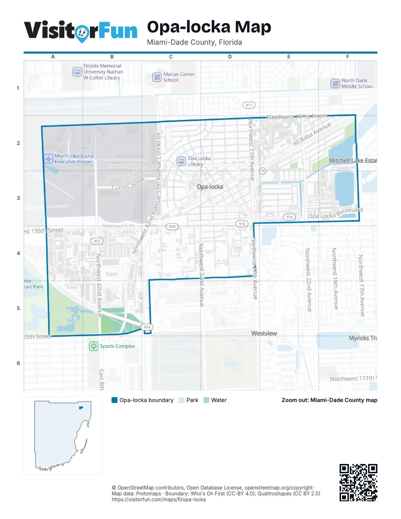
Street index of Opa-locka
Each street on the sheet and the grid squares it crosses.
- Ali Baba AvenueF1, D2, E2, F2, C3, D3
- Northwest 151st StreetF1, C2, D2, E2
- Northwest 18th AvenueF1, F2, F3
- Northwest 19th AvenueF1, F2, F3
- Northwest 145th StreetA2, B2
- Northwest 147th State RoadA2
- Northwest 150th RoadA2
- Northwest 44th AvenueA2, A3
- Northwest 44th CourtA2
- Northwest 144th StreetB2, C2
- Northwest 42nd AvenueB2, B3, B4, B5
- Arabia AvenueC2
- Bagdad AvenueC2, C3
- Bahman AvenueC2, D2, D3
- Banu AvenueC2
- Beder StreetC2, C3
- Curtiss DriveC2, D2
- Douglas RoadC2
- Dunad AvenueC2, D2, C3
- Golf Course BoulevardC2
- Harem AvenueC2
- Jann AvenueC2, D2, C3
- Northwest 33rd CourtC2
- Northwest 37th CtC2
- Northwest 42nd Avenue-37th Avenue ConnectorC2, C3, B4, C4, B5
- Opa Locka BoulevardC2, C3, D3, E3, F3
- Perviz AvenueC2, C3, D3
- Sharar AvenueC2, D2, C3
- Sharazad BoulevardC2, D2, C3
- Sinbad AvenueC2, D2, D3
- Sultan AvenueC2, D2
- Ahmad StreetD2, D3
- Caliph StreetD2, C3, D3
- Codadad StreetD2, D3
- Fisherman StreetD2, B3, C3, D3
- Julnar AvenueD2
- Kalandar StreetD2, D3
- Kasim StreetD2
- Northwest 147th StreetD2, E2
- Northwest 26th AvenueD2, D3, E3
- Northwest 27th AvenueD2, D3, D4
- Northwest 31st AvenueD2, D3, D4
- Peri StreetD2
- Salih StreetD2, C3, D3
- Seaman AvenueD2
- Sesame StreetD2, C3, C4
- Duval StreetE2
- Grant AvenueE2
- Lincoln AvenueE2, F2
- Northwest 143rd StreetE2, F2, E3
- Northwest 149th StreetE2
- Northwest 150th StreetE2
- Northwest 20th AvenueE2, F2, F3
- Northwest 21st CourtE2, E3
- Northwest 22nd AvenueE2, E3
- Northwest 22nd CourtE2, E3
- Northwest 22nd PlaceE2, E3
- Northwest 23rd AvenueE2, E3
- Northwest 23rd CourtE2, E3
- Northwest 23rd PlaceE2, E3
- Northwest 24th AvenueE2, E3
- Northwest 24th CourtE2, E3
- Northwest 25th AvenueE2
- Northwest 25th CourtE2
- Rutland StreetE2, F2, D3
- Washington AvenueE2, F2
- Wilmington StreetE2, F2, D3
- York StreetE2, F2, D3, E3
- Burlington StreetF2, C3, D3, E3
- James StreetF2
- Johnson StreetF2
- Beachley StreetB3
- Curtiss StreetB3, C3
- Ely RoadB3
- Musick StreetB3
- Aladdin StreetC3
- Atlantic AvenueC3, D3, E3
- Northwest 32nd AvenueC3, D3, D4
- Northwest 37th AvenueC3
- Sabur LaneC3
- Superior StreetC3, D3, E3
- West DriveC3, D3
- Medina StreetD3
- Northwest 135th StreetD3, E3, F3, A4, B4, C4
- Northwest 139th StreetD3, E3, F3
- Northwest 141st StreetD3, E3, F3
- Northwest 26th CourtD3
- Northwest 28th AvenueD3, D4
- Northwest 30th AvenueD3, D4
- Opa Locka ExtendedD3
- Vermont StreetD3
- Northwest 136th TerraceE3
- Northwest 140th StreetE3
- Northwest 140th TerraceE3
- Northwest 17th AvenueF3
- Northwest 20th CourtF3
- Northwest 21st AvenueF3
- Northwest 128th StreetA4, B4
- Northwest 133rd StreetA4, B4, D4
- Northwest 43rd AvenueA4, B4
- Northwest 45th AvenueA4
- Northwest 46th AvenueA4
- Northwest 47th AvenueA4, A5, A6
- Northwest 132nd StreetB4, D4
- Northwest 38th AvenueB4, B5
- Northwest 38th CourtB4
- Alexandria DriveC4
- Cairo LaneC4
- Northwest 127th StreetC4, D4
- Northwest 132nd TerraceC4, D4
- Northwest 134th StreetC4, D4
- Northwest 34th AvenueC4
- Port Said RoadC4
- 29th AvenueD4
- Northwest 129th StreetD4
- Northwest 131st StreetD4
- Northwest 29th AvenueD4
- East 65th StreetA5, B5, A6
- East 6th AvenueA5
- Gratigny ParkwayA5, B5, C5
- East 8th AvenueB5
- Northwest 125th StreetB5
- Northwest 123rd StreetC5
- East 4th AvenueA6
- East 5th AvenueA6
Places on the map
- Angelee Day Care Center
- Beacon Hill Center
- BLADE Lounge Miami
- Chevron
- City of Opa-Locka Government Center
- Coast Guard Air Station
- Coast Guard Exchange
- Earlene Dorsett Academy
- Earlene L Dorsett Academy
- Family Dollar
- FBO Ramp
- FBO Terminal
- First Baptist Church
- First Baptist Church of Opa-Locka
- Fisherman Street
- Florida International Academy
- Fontainbleau Aviation
- Fontainebleau Aviation
- Iglesia de Cristo en Opa-Locka
- Ingram Park
- LifeFlight
- Marathon
- McDonald's
- Miami Executive Aviation
- Miami Executive Aviation Ramp
- Miami Helicopter Tours
- Miami-Opa Locka Executive Airport
- Nathan B Young Head Start
- Nathan Young School
- North Country Charter School
- North Dade Community Development Children's Center
- North Regional Park
- Opa - Locka Airport Fire Department Station 25
- Opa Locka Library
- Opa Locka Post Office
- Opa-Locka Branch Public Library
- Opa-Locka Park and Ride
- Segal Park
- Sherbondy Park
- The ARC (Arts and Recreation Center)
Next to Opa-locka
- Myricks Trailer Park
- Westview
© OpenStreetMap contributors, Open Database License, openstreetmap.org/copyright · Map data: Protomaps · Boundary: Who's On First (CC-BY 4.0); Quattroshapes (CC BY 2.0)















